konservasi air dan tanah di wilayah sungai terpilih di aceh
TRANSCRIPT
7/27/2019 Konservasi Air Dan Tanah Di Wilayah Sungai Terpilih Di Aceh
http://slidepdf.com/reader/full/konservasi-air-dan-tanah-di-wilayah-sungai-terpilih-di-aceh 1/70
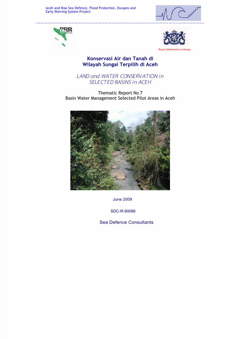
Konservasi Air dan Tanah diWilayah Sungai Terpilih di Aceh
LAND and WATER CONSERVATION in
SELECTED BASINS in ACEH
Thematic Report No 7Basin Water Management Selected Pilot Areas in Aceh
Aceh and Nias Sea Defence, Flood Protection, Escapes andEarly Warning System Project
Royal Netherlands Embassy
Sea Defence Consultants
SDC-R-90086
June 2009
7/27/2019 Konservasi Air Dan Tanah Di Wilayah Sungai Terpilih Di Aceh
http://slidepdf.com/reader/full/konservasi-air-dan-tanah-di-wilayah-sungai-terpilih-di-aceh 2/70
Aceh Nias Sea Defence, Flood Protection, Escapesand Early Warning Project
BRR Concept Note / INFRA 300GI
Land and Water Conservationin Selected Basins in Aceh
June 2009
SDC-R-90086
SEA DEFENCE CONSULTANTS
7/27/2019 Konservasi Air Dan Tanah Di Wilayah Sungai Terpilih Di Aceh
http://slidepdf.com/reader/full/konservasi-air-dan-tanah-di-wilayah-sungai-terpilih-di-aceh 3/70
Land and Water Conservation in Selected Basins in Aceh, June 2009
Aceh Nias Sea Defence, Flood Protection, Escapes and Early Warning Project iBRR Concept Note / INFRA 300GISea Defence Consultants
SUMMARY
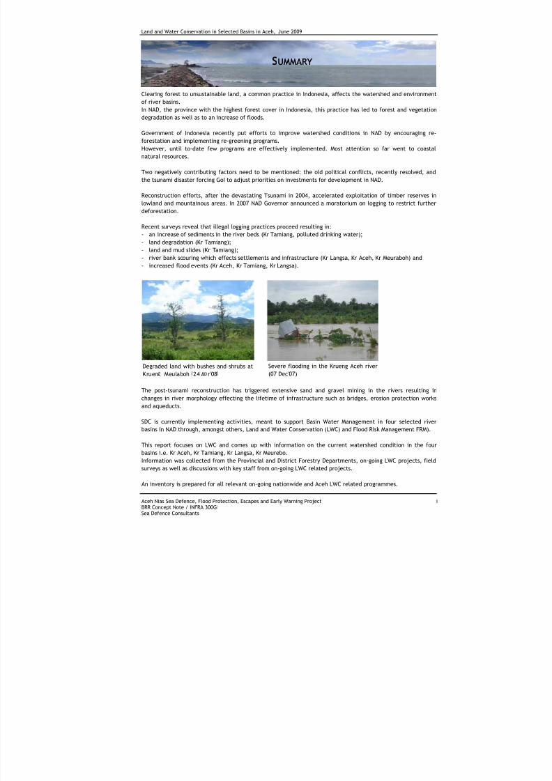
Clearing forest to unsustainable land, a common practice in Indonesia, affects the watershed and environmentof river basins.
In NAD, the province with the highest forest cover in Indonesia, this practice has led to forest and vegetation
degradation as well as to an increase of floods.
Government of Indonesia recently put efforts to improve watershed conditions in NAD by encouraging re-
forestation and implementing re-greening programs.
However, until to-date few programs are effectively implemented. Most attention so far went to coastal
natural resources.
Two negatively contributing factors need to be mentioned: the old political conflicts, recently resolved, and
the tsunami disaster forcing GoI to adjust priorities on investments for development in NAD.
Reconstruction efforts, after the devastating Tsunami in 2004, accelerated exploitation of timber reserves in
lowland and mountainous areas. In 2007 NAD Governor announced a moratorium on logging to restrict further
deforestation.
Recent surveys reveal that illegal logging practices proceed resulting in:
- an increase of sediments in the river beds (Kr Tamiang, polluted drinking water);
- land degradation (Kr Tamiang);
- land and mud slides (Kr Tamiang);
- river bank scouring which effects settlements and infrastructure (Kr Langsa, Kr Aceh, Kr Meuraboh) and
- increased flood events (Kr Aceh, Kr Tamiang, Kr Langsa).
The post-tsunami reconstruction has triggered extensive sand and gravel mining in the rivers resulting in
changes in river morphology effecting the lifetime of infrastructure such as bridges, erosion protection works
and aqueducts.
SDC is currently implementing activities, meant to support Basin Water Management in four selected river
basins in NAD through, amongst others, Land and Water Conservation (LWC) and Flood Risk Management FRM).
This report focuses on LWC and comes up with information on the current watershed condition in the four
basins i.e. Kr Aceh, Kr Tamiang, Kr Langsa, Kr Meurebo.
Information was collected from the Provincial and District Forestry Departments, on-going LWC projects, field
surveys as well as discussions with key staff from on-going LWC related projects.
An inventory is prepared for all relevant on-going nationwide and Aceh LWC related programmes.
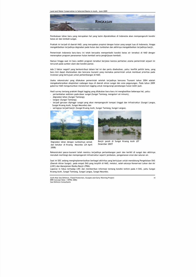
Degraded land with bushes and shrubs at
Kruen Meulaboh 24 A r'08
Severe flooding in the Krueng Aceh river
(07 Dec'07)
7/27/2019 Konservasi Air Dan Tanah Di Wilayah Sungai Terpilih Di Aceh
http://slidepdf.com/reader/full/konservasi-air-dan-tanah-di-wilayah-sungai-terpilih-di-aceh 4/70
Land and Water Conservation in Selected Basins in Aceh, June 2009
Aceh Nias Sea Defence, Flood Protection, Escapes and Early Warning Project iiBRR Concept Note / INFRA 300GISea Defence Consultants
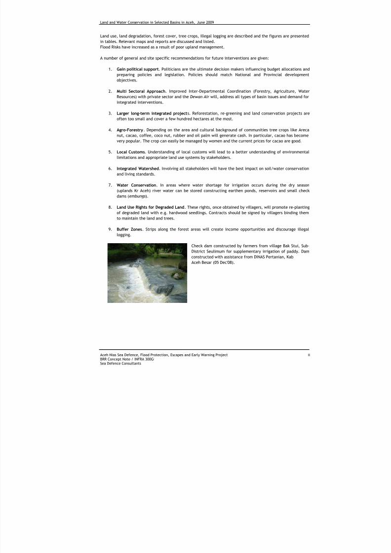
Land use, land degradation, forest cover, tree crops, illegal logging are described and the figures are presented
in tables. Relevant maps and reports are discussed and listed.
Flood Risks have increased as a result of poor upland management.
A number of general and site specific recommendations for future interventions are given:
1. Gain political support. Politicians are the ultimate decision makers influencing budget allocations andpreparing policies and legislation. Policies should match National and Provincial development
objectives.
2. Multi Sectoral Approach. Improved Inter-Departmental Coordination (Forestry, Agriculture, Water
Resources) with private sector and the Dewan Air will, address all types of basin issues and demand for
integrated interventions.
3. Larger long-term integrated projects. Reforestation, re-greening and land conservation projects are
often too small and cover a few hundred hectares at the most.
4. Agro-Forestry. Depending on the area and cultural background of communities tree crops like Areca
nut, cacao, coffee, coco nut, rubber and oil palm will generate cash. In particular, cacao has becomevery popular. The crop can easily be managed by women and the current prices for cacao are good.
5. Local Customs. Understanding of local customs will lead to a better understanding of environmental
limitations and appropriate land use systems by stakeholders.
6. Integrated Watershed. Involving all stakeholders will have the best impact on soil/water conservation
and living standards.
7. Water Conservation. In areas where water shortage for irrigation occurs during the dry season
(uplands Kr Aceh) river water can be stored constructing earthen ponds, reservoirs and small check
dams (embungs).
8. Land Use Rights for Degraded Land. These rights, once obtained by villagers, will promote re-planting
of degraded land with e.g. hardwood seedlings. Contracts should be signed by villagers binding them
to maintain the land and trees.
9. Buffer Zones. Strips along the forest areas will create income opportunities and discourage illegal
logging.
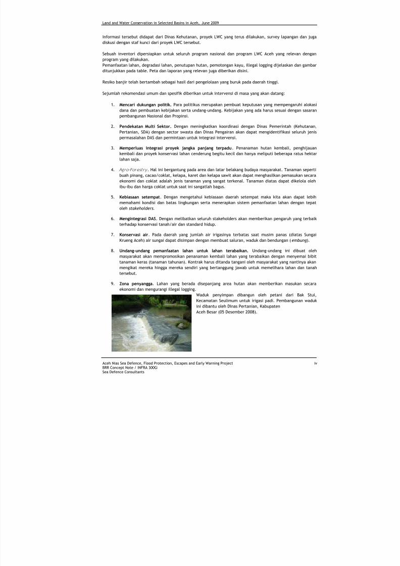
Check dam constructed by farmers from village Bak Stui, Sub-
District Seulimum for supplementary irrigation of paddy. Dam
constructed with assistance from DINAS Pertanian, Kab
Aceh Besar (05 Dec'08).
7/27/2019 Konservasi Air Dan Tanah Di Wilayah Sungai Terpilih Di Aceh
http://slidepdf.com/reader/full/konservasi-air-dan-tanah-di-wilayah-sungai-terpilih-di-aceh 5/70
Land and Water Conservation in Selected Basins in Aceh, June 2009
Aceh Nias Sea Defence, Flood Protection, Escapes and Early Warning Project iiiBRR Concept Note / INFRA 300GISea Defence Consultants
R INGKASAN
Pembukaan lahan baru yang merupakan hal yang lazim dipraktekkan di Indonesia akan mempengaruhi kondisi
batas air dan lembah sungai.
Praktek ini terjadi di daerah NAD, yang merupakan propinsi dengan hutan yang sangat luas di Indonesia, hingga
mengakibatkan terjadinya degradasi pada hutan dan tumbuhan dan akhirnya mengakibatkan terjadinya banjir.
Pemerintah Indonesia baru-baru ini telah berusaha memperbaiki kondisi batas air tersebut di NAD dengan
menerapkan program penanaman hutan kembali serta penghijauan kembali.
Namun hingga saat ini baru sedikit program tersebut berjalan karena perhatian utama pemerintah sejauh ini
tercurah pada sumber alam dan kondisi pantai.
Ada 2 faktor negatif yang berkontribusi dalam hal ini dan perlu disebutkan, yaitu: konflik politik lama, yang
baru kini dapat diselesaikan dan bencana tsunami yang memaksa pemerintah untuk membuat prioritas pada
investasi yang bertujuan untuk perkembangan di NAD.
Usaha rekonstruksi yang dilakukan pemerintah setelah terjadinya bencana Tsunami tahun 2004 adalah
mengakselerasikan eksploitasi cadangan kayu di daerah aliran sungai dan area pegunungan. Pada tahun 2009
gubernur NAD mengumumkan moratorium logging untuk mengurangi penebangan hutan lebih jauh.
Hasil survey tentang praktek illegal logging yang dilakukan baru-baru ini menghasilkan beberapa hal, yaitu:
- pertambahan sedimen pada dasar sungai (Sungai Tamiang, mengotori air minum);
- degradasi lahan (Sungai Tamiang);
- longsor (Sungai Tamiang);
- terjadi gerusan dipinggir sungai yang akan mempengaruhi tempat tinggal dan infrastruktur (Sungai Langsa,Sungai Krueng Aceh, Sungai Meurebo) dan
- seringnya terjadi banjir (Sungai Krueng Aceh, Sungai Tamiang, Sungai Langsa).
Rekonstruksi pasca-tsunami telah memicu terjadinya pertambangan pasir dan kerikil di sungai dan akhirnya
merubah morfologi dan mempengaruhi infrastruktur seperti jembatan, pengamanan erosi dan saluran air.
Saat ini SDC sedang mengimplementasikan berbagai aktivitas yang bertujuan untuk mendukung Pengelolaan DAS
(Daerah Aliran Sungai) pada empat DAS yang terpilih di NAD, melalui, salah satunya Konservasi Lahan dan Air
(LWC) dan Manajemen Resiko Banjir (FRM).
Laporan in fokus terhadap LWC dan memberikan informasi tentang kondisi terkini pada 4 DAS, yaitu Sungai
Krueng Aceh, Sungai Tamiang, Sungai Langsa, Sungai Meurebo.
Degradasi lahan dengan tumbuhnya semak
dan belukar di Krueng Meurebo (24 April
2008)
Banjir parah di Sungai Krueng Aceh (07
Desember 2007
7/27/2019 Konservasi Air Dan Tanah Di Wilayah Sungai Terpilih Di Aceh
http://slidepdf.com/reader/full/konservasi-air-dan-tanah-di-wilayah-sungai-terpilih-di-aceh 6/70
Land and Water Conservation in Selected Basins in Aceh, June 2009
Aceh Nias Sea Defence, Flood Protection, Escapes and Early Warning Project ivBRR Concept Note / INFRA 300GISea Defence Consultants
Informasi tersebut didapat dari Dinas Kehutanan, proyek LWC yang terus dilakukan, survey lapangan dan juga
diskusi dengan staf kunci dari proyek LWC tersebut.
Sebuah inventori dipersiapkan untuk seluruh program nasional dan program LWC Aceh yang relevan dengan
program yang dilakukan.
Pemanfaatan lahan, degradasi lahan, penutupan hutan, pemotongan kayu, illegal logging dijelaskan dan gambar
ditunjukkan pada table. Peta dan laporan yang relevan juga diberikan disini.
Resiko banjir telah bertambah sebagai hasil dari pengelolaan yang buruk pada daerah tinggi.
Sejumlah rekomendasi umum dan spesifik diberikan untuk intervensi di masa yang akan datang:
1. Mencari dukungan politik. Para politikus merupakan pembuat keputusan yang mempengaruhi alokasi
dana dan pembuatan kebijakan serta undang-undang. Kebijakan yang ada harus sesuai dengan sasaran
pembangunan Nasional dan Propinsi.
2. Pendekatan Multi Sektor. Dengan meningkatkan koordinasi dengan Dinas Pemerintah (Kehutanan,
Pertanian, SDA) dengan sector swasta dan Dinas Pengairan akan dapat mengidentifikasi seluruh jenis
permasalahan DAS dan permintaan untuk integrasi intervensi.
3. Memperluas integrasi proyek jangka panjang terpadu. Penanaman hutan kembali, penghijauan
kembali dan proyek konservasi lahan cenderung begitu kecil dan hanya meliputi beberapa ratus hektar
lahan saja.
4. Agro-Forest ry . Hal ini bergantung pada area dan latar belakang budaya masyarakat. Tanaman seperti
buah pinang, cacao/coklat, kelapa, karet dan kelapa sawit akan dapat menghasilkan pemasukan secara
ekonomi dan coklat adalah jenis tanaman yang sangat terkenal. Tanaman diatas dapat dikelola oleh
ibu-ibu dan harga coklat untuk saat ini sangatlah bagus.
5. Kebiasaan setempat. Dengan mengetahui kebiasaan daerah setempat maka kita akan dapat lebih
memahami kondisi dan batas lingkungan serta menerapkan sistem pemanfaatan lahan dengan tepat
oleh stakeholders.
6. Mengintegrasi DAS. Dengan melibatkan seluruh stakeholders akan memberikan pengaruh yang terbaik
terhadap konservasi tanah/air dan standard hidup.
7. Konservasi air. Pada daerah yang jumlah air irigasinya terbatas saat musim panas (diatas Sungai
Krueng Aceh) air sungai dapat disimpan dengan membuat saluran, waduk dan bendungan ( embung).
8. Undang-undang pemanfaatan lahan untuk lahan terabaikan. Undang-undang ini dibuat oleh
masyarakat akan mempromosikan penanaman kembali lahan yang terabaikan dengan menyemai bibit
tanaman keras (tanaman tahunan). Kontrak harus ditanda tangani oleh masyarakat yang nantinya akan
mengikat mereka hingga mereka sendiri yang bertanggung jawab untuk memelihara lahan dan tanah
tersebut.
9. Zona penyangga. Lahan yang berada disepanjang area hutan akan memberikan masukan secara
ekonomi dan mengurangi illegal logging.
Waduk penyimpan dibangun oleh petani dari Bak Stui,
Kecamatan Seulimum untuk irigasi padi. Pembangunan waduk
ini dibantu oleh DInas Pertanian, Kabupaten
Aceh Besar (05 Desember 2008).
7/27/2019 Konservasi Air Dan Tanah Di Wilayah Sungai Terpilih Di Aceh
http://slidepdf.com/reader/full/konservasi-air-dan-tanah-di-wilayah-sungai-terpilih-di-aceh 7/70
Land and Water Conservation in Selected Basins in Aceh, June 2009
Aceh Nias Sea Defence, Flood Protection, Escapes and Early Warning Project vBRR Concept Note / INFRA 300GISea Defence Consultants
TABLE OF CONTENTS
Summary .......................................................................................i
Ringkasan ..................................................................................... iii
Table of Contents .............................................................................. v
List of Abbreviations..........................................................................vii
List of Figures.................................................................................viii
List of Tables ..................................................................................viii
1 Introduction............................................................................. 1
1.1
Background .............................................................................................................. 1
1.2 Current situation........................................................................................................ 3
1.3 Land degradation ....................................................................................................... 4
2 Overview of Available Relevant Information .....................................7
2.1 Land use maps .......................................................................................................... 7
2.2 Land resources reports ................................................................................................ 8
2.3 Information from persons interviewed .............................................................................12
3 Summary of SDC-FRM Findings (Quick-Scan and PRA)........................ 16
3.1 General..................................................................................................................16
3.2 Langsa River Basin.....................................................................................................17
3.3
Tamiang River Basin...................................................................................................18 3.4 Krueng Aceh River basin..............................................................................................19
3.5 Meurebo River Basin...................................................................................................20
4 Land Conservation Programs In Indonesia ...................................... 22
4.1 Nation Wide Land Conservation Programmes .....................................................................22
4.2 Aceh land conservation Programmes and Projects ...............................................................23
5 Institutional Arrangements......................................................... 28
5.1 Multi-sectoral approach ..............................................................................................28
5.2 Community participation .............................................................................................29
6 Concluding Notes..................................................................... 30
7 Recommendations for Programmes In SDC Basins............................. 33
List of References............................................................................ 35
List of Appendices ........................................................................... 38
Appendix A - List of Available Land Use Maps at SDC ................................. 39
Appendix B - Maps ............................................................................ 50
Appendix C - Land Use Area per District/City 2006 ................................... 54
7/27/2019 Konservasi Air Dan Tanah Di Wilayah Sungai Terpilih Di Aceh
http://slidepdf.com/reader/full/konservasi-air-dan-tanah-di-wilayah-sungai-terpilih-di-aceh 8/70
Land and Water Conservation in Selected Basins in Aceh, June 2009
Aceh Nias Sea Defence, Flood Protection, Escapes and Early Warning Project viBRR Concept Note / INFRA 300GISea Defence Consultants
Appendix D - Type and Illegal Activity Cases............................................ 56
Appendix E - Forest Cover Change in Leuser Ecosystem............................. 58
Appendix F - Planted Area and Production in NAD .................................... 59
7/27/2019 Konservasi Air Dan Tanah Di Wilayah Sungai Terpilih Di Aceh
http://slidepdf.com/reader/full/konservasi-air-dan-tanah-di-wilayah-sungai-terpilih-di-aceh 9/70
Land and Water Conservation in Selected Basins in Aceh, June 2009
Aceh Nias Sea Defence, Flood Protection, Escapes and Early Warning Project viiBRR Concept Note / INFRA 300GISea Defence Consultants
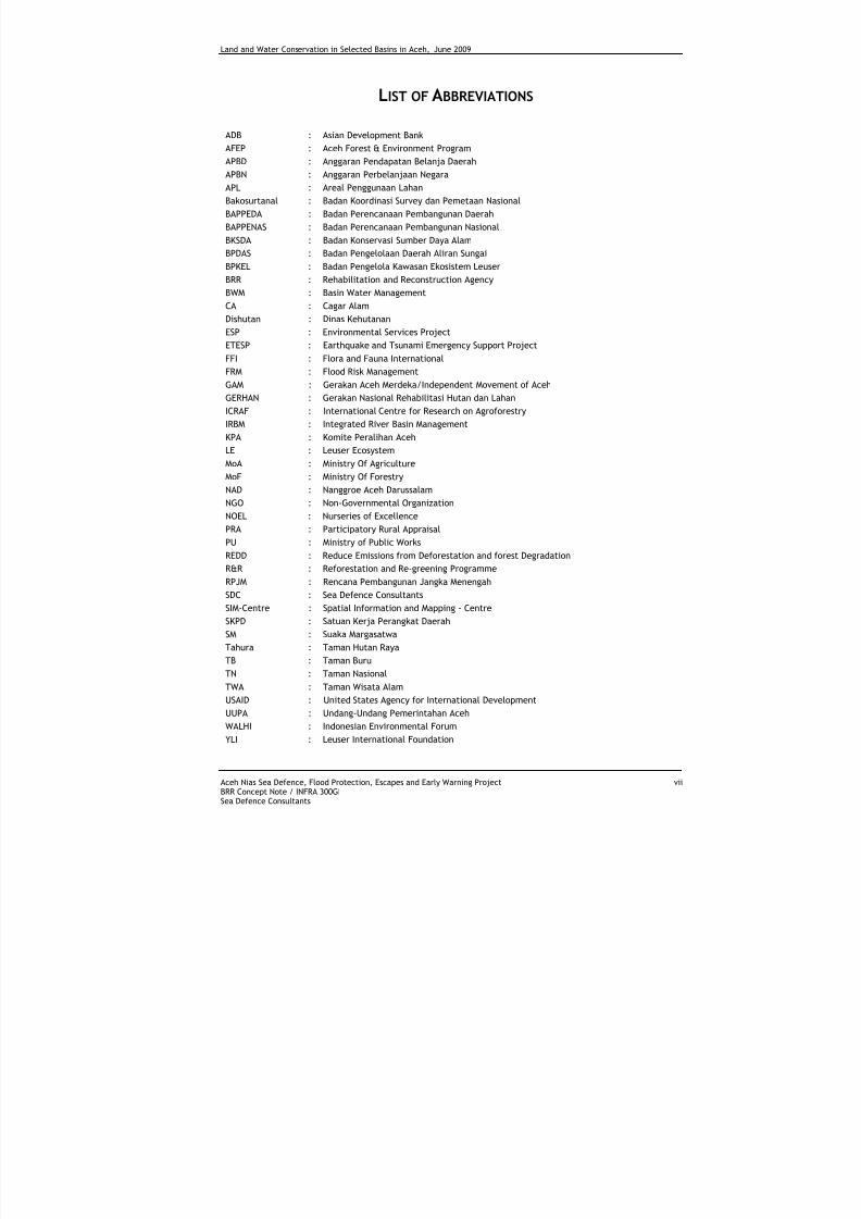
LIST OF ABBREVIATIONS
ADB : Asian Development Bank
AFEP : Aceh Forest & Environment ProgramAPBD : Anggaran Pendapatan Belanja Daerah
APBN : Anggaran Perbelanjaan Negara
APL : Areal Penggunaan Lahan
Bakosurtanal : Badan Koordinasi Survey dan Pemetaan Nasional
BAPPEDA : Badan Perencanaan Pembangunan Daerah
BAPPENAS : Badan Perencanaan Pembangunan Nasional
BKSDA : Badan Konservasi Sumber Daya Alam
BPDAS : Badan Pengelolaan Daerah Aliran Sungai
BPKEL : Badan Pengelola Kawasan Ekosistem Leuser
BRR : Rehabilitation and Reconstruction Agency
BWM : Basin Water Management
CA : Cagar Alam
Dishutan : Dinas Kehutanan
ESP : Environmental Services Project
ETESP : Earthquake and Tsunami Emergency Support Project
FFI : Flora and Fauna International
FRM : Flood Risk Management
GAM : Gerakan Aceh Merdeka/Independent Movement of Aceh
GERHAN : Gerakan Nasional Rehabilitasi Hutan dan Lahan
ICRAF : International Centre for Research on Agroforestry
IRBM : Integrated River Basin Management
KPA : Komite Peralihan Aceh
LE : Leuser EcosystemMoA : Ministry Of Agriculture
MoF : Ministry Of Forestry
NAD : Nanggroe Aceh Darussalam
NGO : Non-Governmental Organization
NOEL : Nurseries of Excellence
PRA : Participatory Rural Appraisal
PU : Ministry of Public Works
REDD : Reduce Emissions from Deforestation and forest Degradation
R&R : Reforestation and Re-greening Programme
RPJM : Rencana Pembangunan Jangka Menengah
SDC : Sea Defence Consultants
SIM-Centre : Spatial Information and Mapping - Centre
SKPD : Satuan Kerja Perangkat Daerah
SM : Suaka Margasatwa
Tahura : Taman Hutan Raya
TB : Taman Buru
TN : Taman Nasional
TWA : Taman Wisata Alam
USAID : United States Agency for International Development
UUPA : Undang-Undang Pemerintahan Aceh
WALHI : Indonesian Environmental Forum
YLI : Leuser International Foundation
7/27/2019 Konservasi Air Dan Tanah Di Wilayah Sungai Terpilih Di Aceh
http://slidepdf.com/reader/full/konservasi-air-dan-tanah-di-wilayah-sungai-terpilih-di-aceh 10/70
Land and Water Conservation in Selected Basins in Aceh, June 2009
Aceh Nias Sea Defence, Flood Protection, Escapes and Early Warning Project viiiBRR Concept Note / INFRA 300GISea Defence Consultants
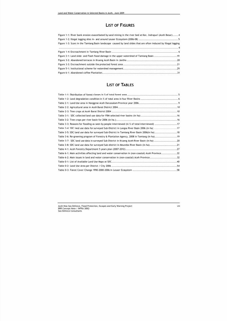
LIST OF FIGURES
Figure 1-1: River bank erosion exacerbated by sand mining in the river bed at Kec. Indrapuri (Aceh Besar)...... 4
Figure 1-2: Illegal logging sites in- and around Leuser Ecosystem (2006-08) ............................................ 5
Figure 1-3: Scars in the Tamiang Basin landscape caused by land slides that are often induced by Illegal logging
....................................................................................................................................... 6
Figure 1-4: Encroachment in Tamiang River Basin ........................................................................... 6
Figure 3-1: Land slide- and Flash flood damage in the upper watershed of Tamiang Basin ..........................19
Figure 3-2: Abandoned terraces in Krueng Aceh Basin in Jantho .........................................................20
Figure 3-3: Encroachment outside the protected forest area .............................................................21
Figure 5-1: Institutional scheme for watershed management.............................................................29
Figure 6-1: Abandoned coffee Plantation.....................................................................................31
LIST OF TABLES
Table 1-1: Distribution of forest classes in % of total forest area ......................................................... 5
Table 1-2: Land degradation condition in % of total area in four River Basins .......................................... 6
Table 2-1: Land Use area in Nanggroe Aceh Darussalam Province year 2006............................................ 9
Table 2-2: Agricultural area in Aceh Barat District 2004...................................................................10
Table 2-3: Tree crops at Aceh Barat District 2004 ..........................................................................10
Table 3-1: SDC collected land use data for FRM selected river basins (in ha) .........................................16
Table 3-2: Tree crops per river basin for 2006 (in ha.).....................................................................16
Table 3-3: Reasons for flooding as seen by people interviewed (in % of total interviewed) .........................17
Table 3-4: SDC land use data for surveyed Sub-District in Langsa River Basin 2006 (in ha) ..........................17
Table 3-5: SDC land use data for surveyed Sub-District in Tamiang River Basin 2006(in ha) .........................18
Table 3-6: Re-greening program of Forestry & Plantation Agency, 2008 in Tamiang (in ha).........................19
Table 3-7: SDC land use data in surveyed Sub-District in Krueng Aceh River Basin (in ha) ..........................20
Table 3-8: SDC land use data for surveyed Sub-district in Meurebo River Basin (in ha)...............................21
Table 4-1: Aceh Forestry Department 5 years plan (2007-2012) ..........................................................27
Table 6-1: Main activities affecting land and water conservation in (non-coastal) Aceh Province..................32
Table 6-2: Main issues in land and water conservation in (non-coastal) Aceh Province...............................32
Table 0-1: List of Available Land Use Maps at SDC..........................................................................40
Table 0-2: Land Use Area per District / City 2006 ..........................................................................54
Table 0-3: Forest Cover Change 1990-2000-2006 in Leuser Ecosystem ..................................................58
7/27/2019 Konservasi Air Dan Tanah Di Wilayah Sungai Terpilih Di Aceh
http://slidepdf.com/reader/full/konservasi-air-dan-tanah-di-wilayah-sungai-terpilih-di-aceh 11/70
Land and Water Conservation in Selected Basins in Aceh, June 2009
Aceh Nias Sea Defence, Flood Protection, Escapes and Early Warning Project 1BRR Concept Note / INFRA 300GISea Defence Consultants
1 INTRODUCTION
1.1 BACKGROUND
Land degradation and mismanagement of watershed in Indonesia have been worsened by increased population
pressures on the limited resources, economic crisis, and lack of food supply. Converting forest or vegetation
clearance to unsustainable land uses and failures in soil conservation are the worst management issues
affecting the watershed environment. Inadequate soil conservation and watershed deterioration result in such
negative impacts as erosion, vegetation degradation, floods, as well as high sediment loads in rivers and
sedimentation in canals and dams.
In view of the above, the Government of Indonesia has been strongly committed to improve watershed
management by intensification of soil conservation and encouraging re-forestation and re-greening programs.
Reforestation is undertaken in state forestland (government land), where as re-greening is undertaken in
private land. However, legislation and policies are still not very well worked out. To make the programs work,
the Government should improve the current policy strategies and programs to overcome the ongoing problems
in the implementation of soil conservation and watershed management.
Aceh is the province with the most forest cover in Indonesia. Due to the decades of political conflict, land
degradation in Aceh Province is not as serious as in most other parts of Indonesia. About 1 percent of the land is
in Aceh is considered very critical. To date, very few re-forestation and re-greening programs are implemented
in lower and middle watersheds. Since the 2004 tsunami, much attention has been paid to rehabilitation of
coastal natural resources.
Forest and watershed issues touch every segment of the civil society. Not only communities living close to the
forest but also communities living along rivers and in densely populated areas in the delta will notice theeffects of land use and watershed management improvements. Protection of the valuable natural resources in
the watershed is therefore of paramount importance.
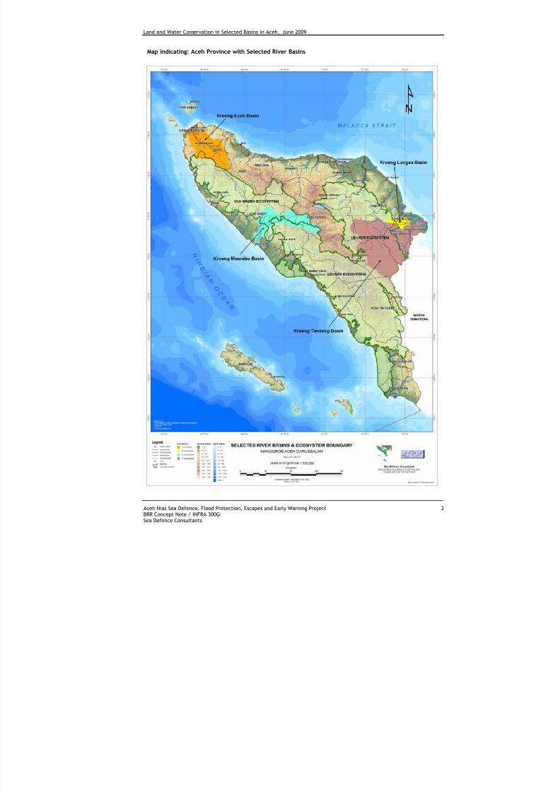
As part of their activities, Sea Defence Consultants (SDC) carries out Integrated River Basin Management (IRBM)
in Aceh Province. “Flood Risk Management in the Selected River Basins” (FRM) is a contributing component
aiming at helping to reduce flood risks and focus on non-structural measures.
The province of Aceh consists of 11 river basins of which 4 basins are included in the Flood Risk Management
pilot project implemented by SDC. The basins concerned are: Krueng Aceh, Tamiang, Langsa and Meureubo.
Information pertained in this report mainly covers these 4 river basins.
7/27/2019 Konservasi Air Dan Tanah Di Wilayah Sungai Terpilih Di Aceh
http://slidepdf.com/reader/full/konservasi-air-dan-tanah-di-wilayah-sungai-terpilih-di-aceh 12/70
Land and Water Conservation in Selected Basins in Aceh, June 2009
Aceh Nias Sea Defence, Flood Protection, Escapes and Early Warning Project 2BRR Concept Note / INFRA 300GISea Defence Consultants
Map indicating: Aceh Province with Selected River Basins
7/27/2019 Konservasi Air Dan Tanah Di Wilayah Sungai Terpilih Di Aceh
http://slidepdf.com/reader/full/konservasi-air-dan-tanah-di-wilayah-sungai-terpilih-di-aceh 13/70
Land and Water Conservation in Selected Basins in Aceh, June 2009
Aceh Nias Sea Defence, Flood Protection, Escapes and Early Warning Project 3BRR Concept Note / INFRA 300GISea Defence Consultants
1.2 CURRENT SITUATION
Deforestation, land degradation and natural resource management are strongly linked to rural poverty and
economic opportunities. Despite its rich natural resources, Aceh remains one of the poorest provinces in
Indonesia. The three-decade long political conflict, economic isolation, lack of technology and weak
institutional set-ups are part of the reason.
The devastating Tsunami and the recent peace agreement are important factors affecting natural resource
management in Aceh. In addition to terrible loss of life, the 2004 Tsunami caused severe damages to coastal
ecosystems including mangrove forest, swamp forest and agricultural lands in the coastal areas. Lowland forest
and mountainous forest have become highly exploited due to the high increase of timber demands during the
reconstruction period. The peace agreement which ended 3 decades of political unrest in Aceh Province and
the need for timber for reconstruction after the tsunami have accelerated illegal logging in the previously
“undisturbed” forest areas.
In Aceh, logging is a traditional occupation which, according to the environment CSO WALHI, accounts for a
decrease in forest cover of some 20,800 hectares every year. The volume of timber required for reconstruction
in Aceh and Nias indicates a large gap between demand and supply (legal). It is estimated that 85% of logs in
Aceh's current markets come from illegally logged forests in northern Sumatra (Greenomics). In 2006,deforestation hit a high of 374,327 hectares forcing the Aceh Governor to announce a total moratorium on
logging in Aceh’s forests on 6 June 2007, for a period of 15 years.
The issuance of Undang Undang Pemerintahan Aceh (UUPA) is considered as a good start for reconstruction of
Aceh, including the development of forestry sectors. UUPA is the new law for Aceh government including
Undang-undang Otonomi Khusus and the Helsinki Agreement between the Indonesian Government and
Independent Movement of Aceh (GAM). UUPA presents clarity on the rights and obligations and authority
distribution among central government, provincial government and district government. Related to natural
resource management, UUPA gives a significant portion of decision making to regional government. In addition,
the Government is currently drafting a new policy (Aceh Green Development Strategy). The new policy focuses
on green economic development consisting of eight main land resources components spread among three
priority categories.
The forest ecosystems are rich in biodiversity, are important for watershed protection and local hydrology, and
also function as carbon pools that regulate the global climate. While Aceh experienced relatively less forest
destruction during the political conflict, the peaceful conditions in the inland areas as well as the demand for
timber for post-tsunami reconstruction have intensified (illegal) logging in recent years. This situation can also
be linked to the increased forest conversion for establishment of monoculture plantations.
The total area of Aceh is 57,365 sq km with an estimated population of about 4.1 million (BPS), or 71.4 persons
per square kilometre. A survey for situational analysis (2007) was carried out along coastal and upland areas in
accessible East Aceh with strong conflict history, and in the less accessible West Aceh with some conflict
history (ICRAF 2008). The survey revealed that about 54% of the district population lives inland and nearly 94%
of these inland people rely on agriculture compared to 55% in the coastal areas. In the inland, an average of
76% of total income derives from agricultural activities, mainly tree crops (rubber, cocoa, areca nuts, coffee,and coconut). Less than 20 percent of Aceh's population lives in Banda Aceh, Lhokseumawe, Langsa, Meulaboh
and other "urban" centre (Mapframe 2005).
The victims of the political conflict are worse off than the tsunami victims. Many post-tsunami reconstruction
and rehabilitation projects largely ignored the inland issues. However, the environmental and economic impact
of reconstruction is reaching far inland. Mining for sand and stone, forest clearance for timber, conversion of
peat land for monoculture plantation and settlements and, ponds for shrimp production are becoming serious
environmental problems. The government rules and regulations emphasize the need for sustainable forest
management by preserving ecological functions, protecting high conservation value forest and implementing
environmentally-based sustainable development.
7/27/2019 Konservasi Air Dan Tanah Di Wilayah Sungai Terpilih Di Aceh
http://slidepdf.com/reader/full/konservasi-air-dan-tanah-di-wilayah-sungai-terpilih-di-aceh 14/70
Land and Water Conservation in Selected Basins in Aceh, June 2009
Aceh Nias Sea Defence, Flood Protection, Escapes and Early Warning Project 4BRR Concept Note / INFRA 300GISea Defence Consultants
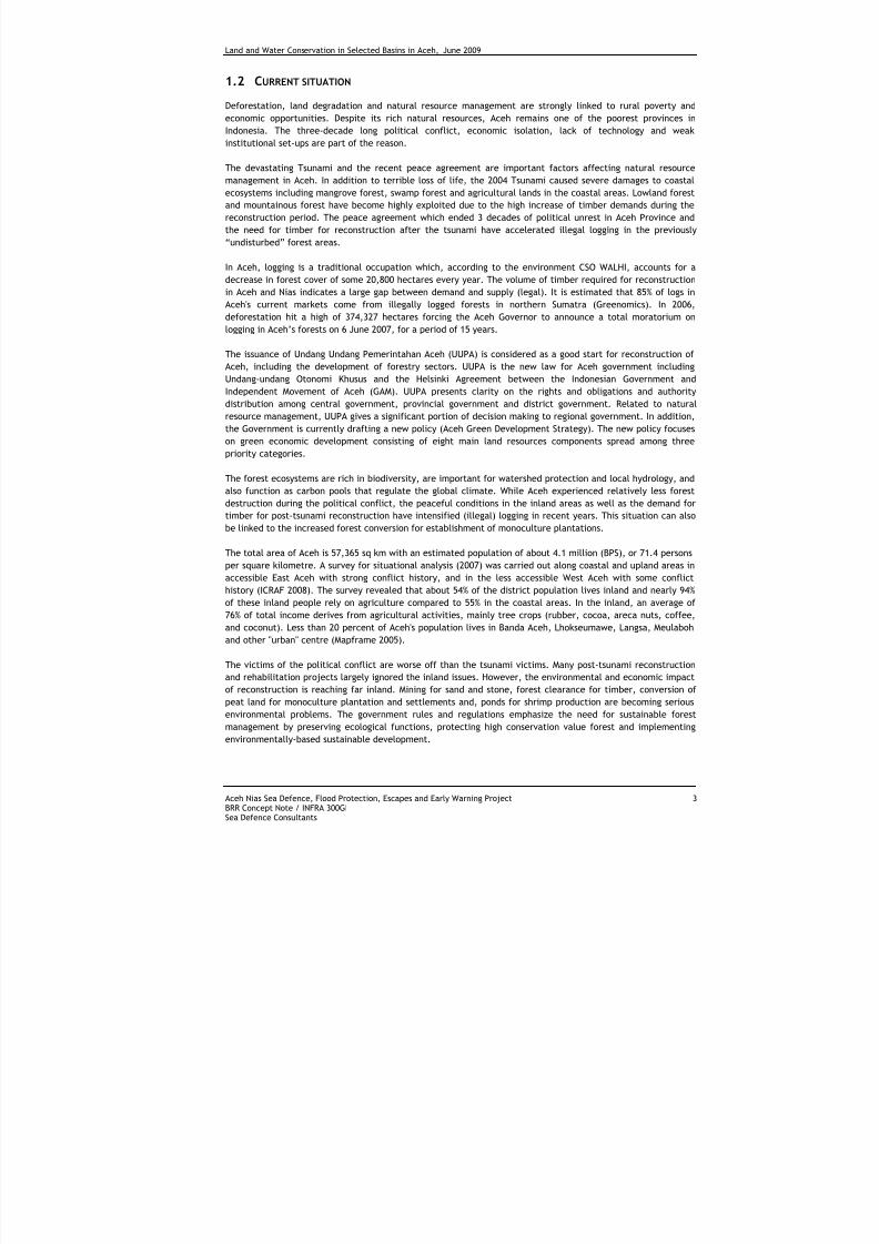
Soil erosion is still limited in most of Aceh Province. Signs like rill, sheet and gully erosion are not profound in
the landscape. River bank erosion is a common feature in the lower river basins
Figure 1-1: River bank erosion exacerbated by sand mining in the river bed at Kec. Indrapuri (Aceh Besar)
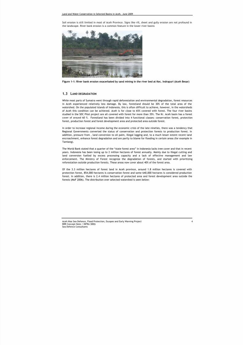
1.3 LAND DEGRADATION
While most parts of Sumatra went through rapid deforestation and environmental degradation, forest resources
in Aceh experienced relatively less damage. By law, forestland should be 30% of the total area of the
watershed. On the populated islands of Indonesia, this is often difficult to achieve, however, in the watersheds
of Aceh this condition can be achieved. Aceh is for close to 65% covered with forest. The four river basins
studied in the SDC Pilot project are all covered with forest for more than 35%. The Kr. Aceh basin has a forest
cover of around 60 %. Forestland has been divided into 4 functional classes: conservation forest, protection
forest, production forest and forest development area and protected area outside forest.
In order to increase regional income during the economic crisis of the late nineties, there was a tendency thatRegional Governments converted the status of conservation and protection forests to production forest. In
addition, pressure from , land conversion to oil palm, illegal logging and, to a much lesser extent recent land
encroachment, enhance forest degradation and are partly to blame for flooding in certain areas (for example in
Tamiang).
The World Bank stated that a quarter of the “state forest area” in Indonesia lacks tree cover and that in recent
years. Indonesia has been losing up to 2 million hectares of forest annually. Mainly due to illegal cutting and
land conversion fuelled by excess processing capacity and a lack of effective management and law
enforcement. The Ministry of Forest recognize the degradation of forests, and started with prioritizing
reforestation outside production forests. These areas now cover about 40% of the forest area.
Of the 3.3 million hectares of forest land in Aceh province, around 1.8 million hectares is covered withprotection forest, 854,000 hectares is conservation forest and some 640,000 hectares is considered production
forest. In addition, there is 2.4 million hectares of protected area and forest development area outside the
forests (MoF 2006). The distribution over selected watershed is seen below:
7/27/2019 Konservasi Air Dan Tanah Di Wilayah Sungai Terpilih Di Aceh
http://slidepdf.com/reader/full/konservasi-air-dan-tanah-di-wilayah-sungai-terpilih-di-aceh 15/70
Land and Water Conservation in Selected Basins in Aceh, June 2009
Aceh Nias Sea Defence, Flood Protection, Escapes and Early Warning Project 5BRR Concept Note / INFRA 300GISea Defence Consultants
Table 1-1: Distribution of forest classes in % of total forest area
CategoriesAceh
Besar
Aceh
Barat*
Kota
Langsa
Aceh
Tamiang
Aceh
Province
Protection forest 27% 44% 10% 24% 32%
Production forest 26% 2% 27% 20% 11%
Conservation Forest 9% - - - 15%
Forest development area and
protected area outside forest39% 54% 64% 56% 42%
Total 100% 100% 100% 100% 100%
Source: Ministry of Forestry 2005
* Meureubo River basin
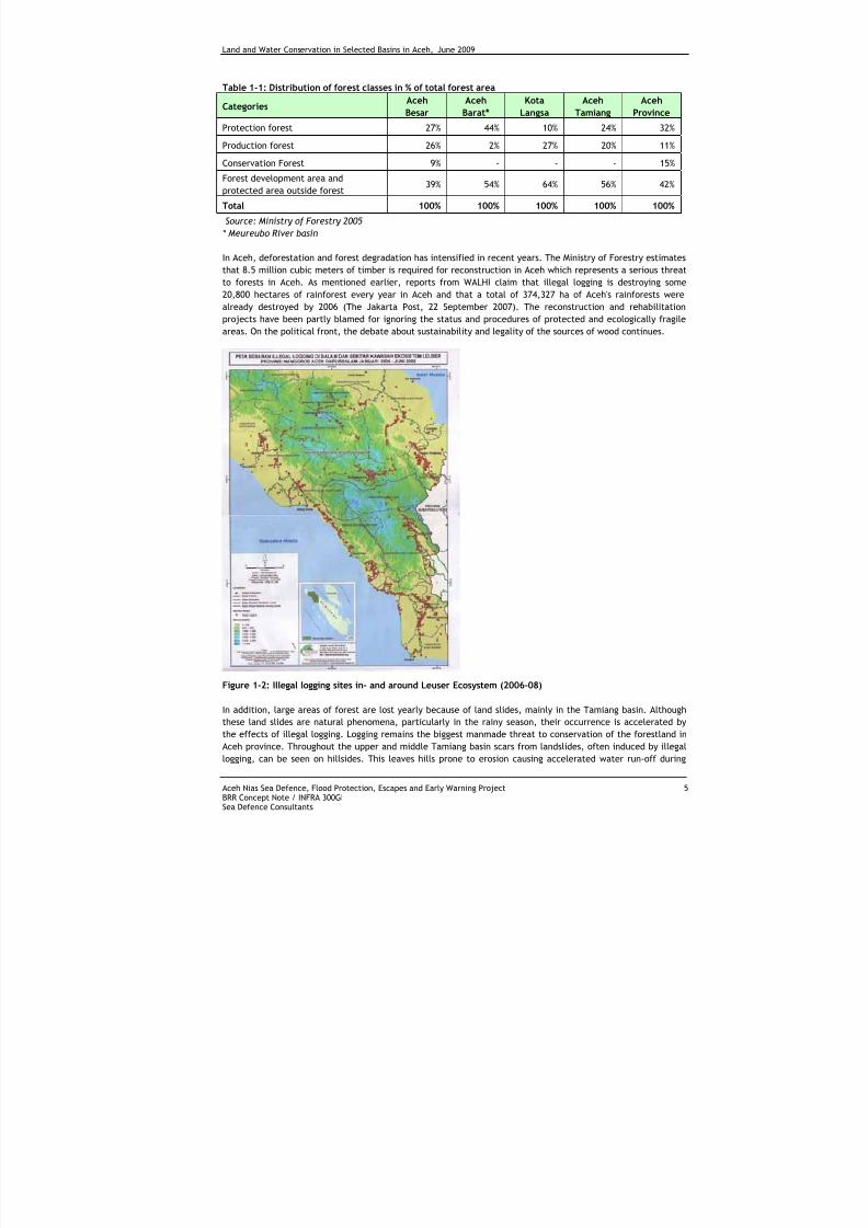
In Aceh, deforestation and forest degradation has intensified in recent years. The Ministry of Forestry estimates
that 8.5 million cubic meters of timber is required for reconstruction in Aceh which represents a serious threat
to forests in Aceh. As mentioned earlier, reports from WALHI claim that illegal logging is destroying some
20,800 hectares of rainforest every year in Aceh and that a total of 374,327 ha of Aceh's rainforests were
already destroyed by 2006 (The Jakarta Post, 22 September 2007). The reconstruction and rehabilitationprojects have been partly blamed for ignoring the status and procedures of protected and ecologically fragile
areas. On the political front, the debate about sustainability and legality of the sources of wood continues.
Figure 1-2: Illegal logging sites in- and around Leuser Ecosystem (2006-08)
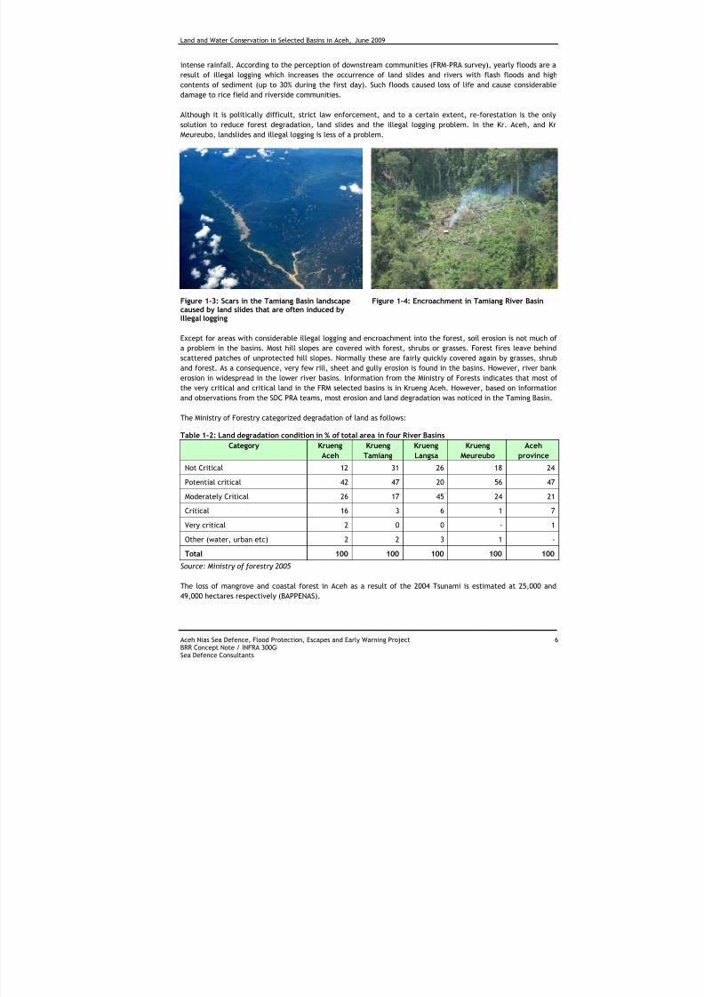
In addition, large areas of forest are lost yearly because of land slides, mainly in the Tamiang basin. Although
these land slides are natural phenomena, particularly in the rainy season, their occurrence is accelerated by
the effects of illegal logging. Logging remains the biggest manmade threat to conservation of the forestland in
Aceh province. Throughout the upper and middle Tamiang basin scars from landslides, often induced by illegal
logging, can be seen on hillsides. This leaves hills prone to erosion causing accelerated water run-off during
7/27/2019 Konservasi Air Dan Tanah Di Wilayah Sungai Terpilih Di Aceh
http://slidepdf.com/reader/full/konservasi-air-dan-tanah-di-wilayah-sungai-terpilih-di-aceh 16/70
Land and Water Conservation in Selected Basins in Aceh, June 2009
Aceh Nias Sea Defence, Flood Protection, Escapes and Early Warning Project 6BRR Concept Note / INFRA 300GISea Defence Consultants
intense rainfall. According to the perception of downstream communities (FRM-PRA survey), yearly floods are a
result of illegal logging which increases the occurrence of land slides and rivers with flash floods and high
contents of sediment (up to 30% during the first day). Such floods caused loss of life and cause considerable
damage to rice field and riverside communities.
Although it is politically difficult, strict law enforcement, and to a certain extent, re-forestation is the only
solution to reduce forest degradation, land slides and the illegal logging problem. In the Kr. Aceh, and KrMeureubo, landslides and illegal logging is less of a problem.
Figure 1-3: Scars in the Tamiang Basin landscapecaused by land slides that are often induced byIllegal logging
Figure 1-4: Encroachment in Tamiang River Basin
Except for areas with considerable illegal logging and encroachment into the forest, soil erosion is not much of
a problem in the basins. Most hill slopes are covered with forest, shrubs or grasses. Forest fires leave behind
scattered patches of unprotected hill slopes. Normally these are fairly quickly covered again by grasses, shrub
and forest. As a consequence, very few rill, sheet and gully erosion is found in the basins. However, river bankerosion in widespread in the lower river basins. Information from the Ministry of Forests indicates that most of
the very critical and critical land in the FRM selected basins is in Krueng Aceh. However, based on information
and observations from the SDC PRA teams, most erosion and land degradation was noticed in the Taming Basin.
The Ministry of Forestry categorized degradation of land as follows:
Table 1-2: Land degradation condition in % of total area in four River Basins
Category Krueng
Aceh
Krueng
Tamiang
Krueng
Langsa
Krueng
Meureubo
Aceh
province
Not Critical 12 31 26 18 24
Potential critical 42 47 20 56 47
Moderately Critical 26 17 45 24 21
Critical 16 3 6 1 7
Very critical 2 0 0 - 1
Other (water, urban etc) 2 2 3 1 -
Total 100 100 100 100 100
Source: Ministry of forestry 2005
The loss of mangrove and coastal forest in Aceh as a result of the 2004 Tsunami is estimated at 25,000 and
49,000 hectares respectively (BAPPENAS).
7/27/2019 Konservasi Air Dan Tanah Di Wilayah Sungai Terpilih Di Aceh
http://slidepdf.com/reader/full/konservasi-air-dan-tanah-di-wilayah-sungai-terpilih-di-aceh 17/70
Land and Water Conservation in Selected Basins in Aceh, June 2009
Aceh Nias Sea Defence, Flood Protection, Escapes and Early Warning Project 7BRR Concept Note / INFRA 300GISea Defence Consultants
2 OVERVIEW OF AVAILABLE R ELEVANT INFORMATION
In view of the long lasting political disturbance in Aceh, little attention was paid to land use planning andfarming system research Aceh Province. The 2004 tsunami and the signing of the peace agreement (2005)
changed this situation. The tsunami caused severe damage to coastal agricultural land and coastal vegetation
and the peace agreement opened the inland of Aceh to new settlers and increased mining and illegal logging,
exacerbated by the need for construction material for rebuilding activities after the tsunami.
Since 2005, a number of donor organizations are working on coastal land use plans and rehabilitation of the
agricultural land. Restoration of agricultural land, coastal vegetation and salinity problems were major topics in
the reconstruction and rehabilitation programs. It is therefore no surprise that most land use maps and reports
related to land use, land degradation, farming systems and soil conservation cover the tsunami affected coastal
region of the west coast of Aceh.
Now, with the peace agreement in place for a couple of years, more attention is paid to land use and landdegradation away from the coast. References of relevant reports are given in Appendix A.
2.1 LAND USE MAPS
SDC collected a number of land use maps to be used as the basis for FRM. Recent land use maps covering the
entire Province came from Bappeda Province NAD (2004/05) and from YLI (Leuser International Foundation) the
latter was provided by the SIM Centre -BRR and is for the year 2005/06. Both maps are based on satellite
imagery. The Bappeda land use maps were considered to be too general; as a consequence the FRM team is
using the YLI map. Some adjustments were made concerning demarcation of settlements. The YLI maps have
some cloud cover, particular over Aceh river basin.
Ministry of Forestry is preparing a land use map based on 2007 data. The report and maps are completed butnot yet approved. Hence, the data could not be released. It is expected that data and maps will be available
before the end of 2008.
- Basin Maps (Krueng Aceh, Krueng Langsa, Tamiang River, Krueng Meureubo) – SDC
Basin maps for the 4 selected river basins are available. The source of the data comes from the Bakosurtanal’s
1978 Topographic Map, SRTM Version 3, Provide by http://srtm.csi.cgiar.org, Balai Wilayah Sungai 1, Dinas
Sumber Daya Air NAD 2007, BAPPEDA Aceh Besar, Aceh Tamiang and Langsa 2008, Data has been distributed by
SIM-Centre BRR in 2008 and has been updated using BAPPEDA Aceh Besar, Aceh Tamiang and Langsa data. Type
of imagery is JPEG and Map scale printout on A3 varies from 1: 250,000, 1: 150,000, 1:350.000, and 1: 400.000.
This map shows information of Q stations, Rainfall stations, and topography for each of the areas.
- SDC Land Use Maps (Krueng Aceh, Krueng Langsa, Tamiang River, Krueng Meureubo and NAD Province) –
2008
Land use maps for the 4 selected river basins and NAD province are available. No data from before 2001 was
found for Aceh Province. The source of the data comes from the Yayasan Leuser International (YLI) 2005-2006
Land Use, administrative boundaries and names are from Bakosurtanal’s 1978 Topographic Map, surveyed by
BAPPEDA Aceh Besar in 2008. Road and rivers are from Bakosurtanal’s 1978 Topographic Maps. Kecamatan
boundary and name in Langsa and Aceh Tamiang refer to BAPPEDA Kota Langsa and Aceh Tamiang. Type of
imagery is JPEG and map scale printout on A3 varies from 1: 250,000, 1:120.000, 1:350.000, 1:375.000 and for
the province land use maps the scale is 1:800.000.The maps indicate bare area, bush, cultivation mosaic, fish
pond, lake/reservoir, logged/degraded forest, logged/degraded swamp forest, mining, mixed, non-irrigated
agriculture, plantation, primary forest, production forest, rice fields, Secondary forest, secondary mangrove
forest, secondary swamp forest, settlement, swamp, and water are also indicated.
7/27/2019 Konservasi Air Dan Tanah Di Wilayah Sungai Terpilih Di Aceh
http://slidepdf.com/reader/full/konservasi-air-dan-tanah-di-wilayah-sungai-terpilih-di-aceh 18/70
Land and Water Conservation in Selected Basins in Aceh, June 2009
Aceh Nias Sea Defence, Flood Protection, Escapes and Early Warning Project 8BRR Concept Note / INFRA 300GISea Defence Consultants
- Forest Cover Change Monitoring 1990, 2000, 2005, 2006 - Leuser International Foundation
Leuser International Foundation produced forest cover maps for 4 Districts: Aceh Barat (scale 1:90,000), Aceh
Besar (1:100,000), Aceh Timur (1: 125,000) and Aceh Tamiang (1:80,000). The maps give useful information on
forest cover changes in the districts since 1990. The source of data is from a number of sources including:
Rupabumi Digital Indonesian Map, BAKOSURTANAL (1978), Ministry of Forestry Decree No 190/KPTS-II/2001,
Ratification of The Leuser Ecosystem boundary in Nanggroe Aceh Darussalam Province, Spot-5 Satellite Imagery,
Landsat TM and ETM Satellite Imagery. Map scale varies from 1:80,000 to 1: 125,000 (A0 print) and are in JPEG
and PDF. The maps portray forest cover for 1990, 2000 and for 2005/2006. It also shows non-forested areas.
- Map Album Report – BRR: “Pengendalian Kegiatan Rehabilitasi Hutan Mangrove dan Hutan Pantai di
Pesisir Nanggroe Aceh Darussalam”
The document gives maps of mangrove rehabilitation locations along the coast of NAD Province that have been
carried out since 2006. The maps in this report are in PDF format.
- Environmental Sensitivity Maps – Earth Quake and Tsunami Emergency Support Project (ETESP); Spatial
Planning & Environmental Management (ADB/BRR)
The Environmental Sensitivity Maps are information and planning tools to be used by Government Agencies,
international and national NGOs in development decisions. They can help to determine the sensitivity ofspecific areas and the need for associated environmental impact assessments; the need for area protection and
give an indication of go-no-go areas for specific development activities. The maps are only suitable for initial
planning purposes. ETESP produced one sensitivity map sheet for Aceh province (scale 1:1,100,000) and 19 map
sheets covering all Districts at scale 1:250,000.All maps are available in PDF format. It is the intention that
maps will be updated regularly.
- Illegal Logging Location maps inside and around Leuser Ecosystem Nanggroe Aceh Darussalam Province
2006 – June 2008
The illegal logging map is produce by Leuser International Foundation. It shows spots/location of illegal logging
activity around Leuser Ecosystem as monitored by Leuser International Foundation from January 2006 until June
2008. The source of data is from a number of sources including Rupabumi Digital Indonesia. Map scale 1:50.000,
Bakosurtanal, 1978, Ministry of Forestry Decree No 190/KPTS-II/2001. Ratification of the Leuser Ecosystemboundary in Nanggroe Aceh Darussalam Province if based on Ministry of Forestry Decree 10193/Kpts-
II/2002.Ratification of the Leuser Ecosystem boundary in Sumatera Utara Province is through Digital Elevation
Model (25 m) YLI, Field Survey, YLI, January 2006-Juni 2008. Map scale is 1:850.000 and in JPEG and PDF
- Environmental Geology Profile for Aceh Tamiang, Aceh Jaya, Aceh Tengah, and Aceh Singkil –
Departemen Energi dan Sumber Daya Mineral and BRR
A number of relevant maps accompany the report. Maps include Land Use Map, Geology Map, Land Elevation
Map, Rock and Soil Support Map, Aquifer Productivity Map, Land Movement Potential Map, Earthquake Map and
Geology Environmental Map, all based on interpretation of Landsat Citra. The data comes from a number of
sources including satellite imagery, Central Survey Geology Langsa Sheet Year 1981, Basic Maps Topography
Aceh Tamiang (Bakosurtanal) and Interpretation results of Aceh Tamiang environmental geological team, Survey
Geology Map 2001.
A list with all available land use maps is presented in Appendix B
2.2 LAND RESOURCES REPORTS
Again most available land resources reports deal with land use and land degradation in the tsunami affected
west coast of Aceh. Areas covered are relatively small and include coastal forestry (mangrove re-forestation)
agro-forestry and issues related to saline soils. An example of such a report is given below (Aceh Barat). A
number of the land use maps mentioned in the section above, are accompanied by a report describing land use
types and giving total areas under specific land use types.
7/27/2019 Konservasi Air Dan Tanah Di Wilayah Sungai Terpilih Di Aceh
http://slidepdf.com/reader/full/konservasi-air-dan-tanah-di-wilayah-sungai-terpilih-di-aceh 19/70
Land and Water Conservation in Selected Basins in Aceh, June 2009
Aceh Nias Sea Defence, Flood Protection, Escapes and Early Warning Project 9BRR Concept Note / INFRA 300GISea Defence Consultants
Reports related to forest cover are available from Leuser International Foundation and Ministry of Forestry.
Reports mainly cover forest conservation, forest degradation and forest types and production.
- Pengembangan Sumberdaya Pesisir dan Laut Pantai Timur dan Pantai Barat Provinsi Nanggroe Aceh
Darussalam (Pasca Tsunami) - PT. GEOTRAV BHUANA SURVEY
The book gives an analysis of land use per District in Aceh Province for 2006. It identifies and gives an inventoryof coastal resources and land use in east and west coast of Aceh Province. The information also includes
Terrestrial, Bathymetry and Tidal Level data, Oceanography data, Coastal and Marine Ecosystem (Mangrove and
Coral Reef) and social economy and gives information on disaster and risk data collection. In the last chapter a
draft strategic plan and management direction for coastal and marine resources in east and west coast NAD
Province is given.
Detailed information on land use per District is given in Appendix 3.
- Coastal Report - BRR (PDF file): “Pengendalian Kegiatan Rehabilitasi Hutan Mangrove dan Hutan Pantai di
Pesisir Nanggroe Aceh Darussalam”.
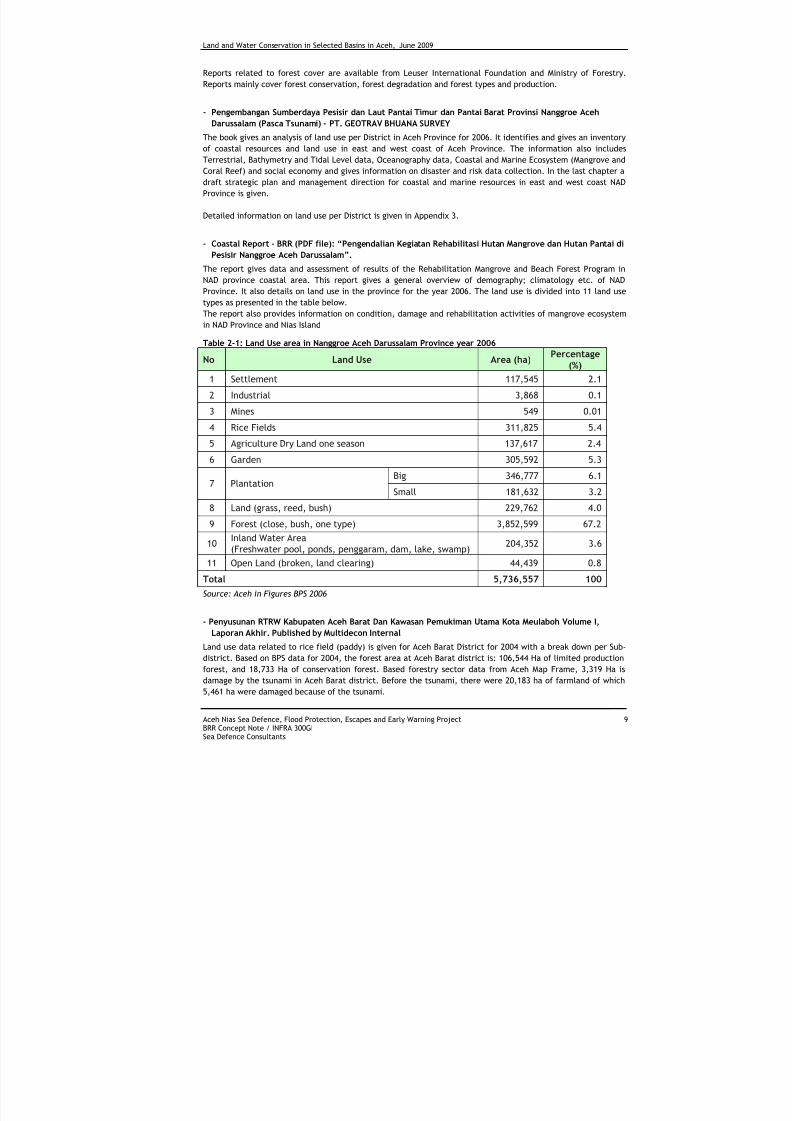
The report gives data and assessment of results of the Rehabilitation Mangrove and Beach Forest Program in
NAD province coastal area. This report gives a general overview of demography; climatology etc. of NADProvince. It also details on land use in the province for the year 2006. The land use is divided into 11 land use
types as presented in the table below.
The report also provides information on condition, damage and rehabilitation activities of mangrove ecosystem
in NAD Province and Nias Island
Table 2-1: Land Use area in Nanggroe Aceh Darussalam Province year 2006
No Land Use Area (ha) Percentage
(%)
1 Settlement 117,545 2.1
2 Industrial 3,868 0.1
3 Mines 549 0.014 Rice Fields 311,825 5.4
5 Agriculture Dry Land one season 137,617 2.4
6 Garden 305,592 5.3
Big 346,777 6.17 Plantation
Small 181,632 3.2
8 Land (grass, reed, bush) 229,762 4.0
9 Forest (close, bush, one type) 3,852,599 67.2
10Inland Water Area(Freshwater pool, ponds, penggaram, dam, lake, swamp)
204,352 3.6
11 Open Land (broken, land clearing) 44,439 0.8
Total 5,736,557 100
Source: Aceh in Figures BPS 2006
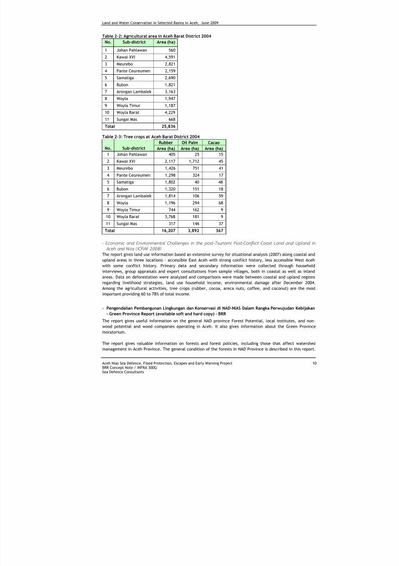
- Penyusunan RTRW Kabupaten Aceh Barat Dan Kawasan Pemukiman Utama Kota Meulaboh Volume I,
Laporan Akhir. Published by Multidecon Internal
Land use data related to rice field (paddy) is given for Aceh Barat District for 2004 with a break down per Sub-
district. Based on BPS data for 2004, the forest area at Aceh Barat district is: 106,544 Ha of limited production
forest, and 18,733 Ha of conservation forest. Based forestry sector data from Aceh Map Frame, 3,319 Ha is
damage by the tsunami in Aceh Barat district. Before the tsunami, there were 20,183 ha of farmland of which
5,461 ha were damaged because of the tsunami.
7/27/2019 Konservasi Air Dan Tanah Di Wilayah Sungai Terpilih Di Aceh
http://slidepdf.com/reader/full/konservasi-air-dan-tanah-di-wilayah-sungai-terpilih-di-aceh 20/70
Land and Water Conservation in Selected Basins in Aceh, June 2009
Aceh Nias Sea Defence, Flood Protection, Escapes and Early Warning Project 10BRR Concept Note / INFRA 300GISea Defence Consultants
Table 2-2: Agricultural area in Aceh Barat District 2004
No. Sub-district Area (ha)
1 Johan Pahlawan 560
2 Kawai XVI 4,591
3 Meurebo 2,821
4 Pante Ceureumen 2,159
5 Samatiga 2,690
6 Bubon 1,821
7 Arongan Lambalek 3,163
8 Woyla 1,947
9 Woyla Timur 1,187
10 Woyla Barat 4,229
11 Sungai Mas 668
Total 25,836
Table 2-3: Tree crops at Aceh Barat District 2004
Rubber Oil Palm Cacao
No. Sub-district Area (ha) Area (ha) Area (ha)
1 Johan Pahlawan 405 25 15
2 Kawai XVI 2,117 1,712 45
3 Meurebo 1,426 751 41
4 Pante Ceureumen 1,298 324 17
5 Samatiga 1,802 40 48
6 Bubon 1,320 151 18
7 Arongan Lambalek 1,814 106 59
8 Woyla 1,196 294 68
9 Woyla Timur 744 162 910 Woyla Barat 3,768 181 9
11 Sungai Mas 317 146 37
Total 16,207 3,892 367
- Economic and Envir onmenta l Chall enges in the post-T sunami Post -Conf l i ct Coast Land and Upla nd in
Aceh and Ni as (ICRAF 2008 )
The report gives land use information based an extensive survey for situational analysis (2007) along coastal and
upland areas in three locations - accessible East Aceh with strong conflict history, less accessible West Aceh
with some conflict history. Primary data and secondary information were collected through household
interviews, group appraisals and expert consultations from sample villages, both in coastal as well as inland
areas. Data on deforestation were analyzed and comparisons were made between coastal and upland regions
regarding livelihood strategies, land use household income, environmental damage after December 2004.
Among the agricultural activities, tree crops (rubber, cocoa, areca nuts, coffee, and coconut) are the most
important providing 60 to 78% of total income.
- Pengendalian Pembangunan Lingkungan dan Konservasi di NAD-NIAS Dalam Rangka Perwujudan Kebijakan
- Green Province Report (available soft and hard copy) - BRR
The report gives useful information on the general NAD province Forest Potential, local institutes, and non-
wood potential and wood companies operating in Aceh. It also gives information about the Green Province
moratorium.
The report gives valuable information on forests and forest policies, including those that affect watershed
management in Aceh Province. The general condition of the forests in NAD Province is described in this report.
7/27/2019 Konservasi Air Dan Tanah Di Wilayah Sungai Terpilih Di Aceh
http://slidepdf.com/reader/full/konservasi-air-dan-tanah-di-wilayah-sungai-terpilih-di-aceh 21/70
Land and Water Conservation in Selected Basins in Aceh, June 2009
Aceh Nias Sea Defence, Flood Protection, Escapes and Early Warning Project 11BRR Concept Note / INFRA 300GISea Defence Consultants
Aceh forest spread from Weh Island until South Aceh in Singkil District including Simeulue Island. The report
gives information on the differences in forest cover and condition for each district. Forest use, functional
aspects and level of degradation are given. The Aceh highlands have forests that spread from Ulu Masen in the
north and west to Leuser Ecosystem in south and southeast of Aceh.
- Compilation Report, Illegal Forest Activity monitoring inside and around Leuser Ecosystem NAD Province –Leuser International Foundation (Hardcopy)
The monitoring report compiles details on illegal logging and land grabbing activities effecting land degradation
and land use changes in and around Leuser Ecosystem. The report is based on monitoring activities carried out
over 2, 5 years (January 2006 – June 2008.). 5.091 cases of illegal activity inside and around of Leuser
Ecosystem were recorded, consisting of: 2.675 illegal logging case/sites, 1996 encroachment sites (land
grabbing) and 3 locations of mining. Table 1 in Appendix F gives more details on the illegal activity per
district/city in the period January 2006 – June 2008.
I l legal logging
Based on the findings, it is clear that there is an increase in intensity of illegal logging. During 2006, 547 cases
were recorded, during 2007 1278 cases and during the first half of 2008 already, 850 illegal cases were noted.
Most cases found in Aceh Selatan District followed by Aceh Barat Daya (393 cases), Aceh Tamiang (303 cases)
and Subussalam city (279 cases). For details see table 2 in Appendix F. A map showing Illegal logging sites in-
and around Leuser Ecosystem (2006-08) can be seen in Chapter 1.3 of this report. Encroachment
Cases of encroachment were also highest in 2007 (869 cases) compared to 363 cases in 2006 and 164 cases in
the first half of 2008. If the trend remains the same for 2008, there will be a considerable reduction of illegal
encroachment for the year 2008. Most encroachment took place in Aceh Tenggara. See table 3 Appendix F for
more details.
Mining
Three new illegal mining sites were recorded inside Leuser Ecosystem (open gold mining steel mines and a
marble mines).
- Environmental Sensitivity Mapping – Earth Quake and Tsunami emergency Support Project (ETESP) Spatial
Planning& Environmental Management
In addition to 19 maps sheets (scale 1: 250,000) indication ecosystem status and their environmental sensitivity,
the document also includes a comprehensive user guide and analysis and distribution of vegetation and land
use. Details on the maps are given in section 1 of this report.
- Environmental Geology Profile of Aceh Province. (BBR)
The geological profile presents maps and gives data on geology, elevation and morphology, rock and soil
supporting issues, ground water productivity, mining potential. It also gives useful information on land
movement potential, earthquake and flood potential.
- Data Base Book Ministry of Forest GERHAN NAD Province Program – BPDAS
The books give summaries of Gerhan project and program locations in NAD Province from 2004 until 2006. The
book also provides information on critical land per district and provides maps of Gerhan program location in
NAD Province
- SDC Land use information data collection
In addition to some localized urban land use information required for urban drainage and coastal protection,
SDC collected land use data for river basins as part the activities of the Flood Risk Management Project. (For
details, see Chapter 3)
7/27/2019 Konservasi Air Dan Tanah Di Wilayah Sungai Terpilih Di Aceh
http://slidepdf.com/reader/full/konservasi-air-dan-tanah-di-wilayah-sungai-terpilih-di-aceh 22/70
Land and Water Conservation in Selected Basins in Aceh, June 2009
Aceh Nias Sea Defence, Flood Protection, Escapes and Early Warning Project 12BRR Concept Note / INFRA 300GISea Defence Consultants
2.3 INFORMATION FROM PERSONS INTERVIEWED
In order to get a broader picture of the condition of the natural resources in Aceh, discussions with a number of
people involved in land conservation and natural resource management have been held. People met included
those involved in donor funded projects and people working for relevant Government organizations. A summary
of the discussions is given below.
- S. Sembiring Meliala, Kabid Program Forestry-Forestry Department
Aceh Forest (62%) is still in good condition according to forestry department. There are some forestry programs
around Aceh including re-forestation within forest area and HTL/Tahura/People forest parks outside the forest
area. Agroforestry and social forestry was carried out in 2004. Unfortunately, he did not have specific
information on locations and area covered. Re-planting of mangroves is predominantly carried out by BRR. Most
of the data on forestry and re-forestation was lost due to the tsunami.
Mr. Sembiring introduced us to the BP-DAS, the department who organizes all project in River Catchments area.
Contact person in BP-DAS: Drs. Saiful Anwar: 08159190064. He also informed us about the existence of the
“Letter Acceptance” by Aceh Governor No. 19 date 19 May 1999 about forest and water function.
- Michael Griffith and Tedi Gunawarman, Badan Pengelola Kawasan Ekosistem Leuser (BPKEL).
BPKEL project is establishing a GIS data base for all their information. The GIS database is expected to be
operational before the end of 2008. Discussed land degradation and flooding in the Leuser project area.
According to Griffith, there is a clear correlation between forest/land cover and flooding. In less forested
areas, soils get saturated quickly resulting in increased run-off and risks of land slides. Also, in deforested
areas, rivers have less water during the dry season.
In the Tamiang river basin, scars seen on hillsides are predominantly caused by land slides. Because of the
steep slopes and soil types, landslides are natural phenomena in this watershed. However, they are often
induced by illegal logging activities and earthquakes.
Landslides block rivers and build up water. Many people have died because of flooding caused by flash flood
from the breakage of such river plugs. Based on their experience, landslide areas recover fairly quickly through
re-generation of the forest. Most areas are completely covered again within 20 years.
- Gerry A. Shea, Team Leader Community and Rural Development Earthquake and Tsunami Emergency
Support Project (ADB)
The project deals primarily with agricultural development in the tsunami affected areas along the west coast of
Aceh. Over the last year more attention has been given to lower foot slopes. With the increase of the price for
cacao farmers are keen to start agroforestry including cacao. Currently the price for cacao is around 18,000 IDR
per kilo. After cacao, rubber is liked by farmers. Since rubber trees only produce after many years, the project
established extension offices to teach farmers about multi-storey cropping including rubber. Mr. Shea
mentioned that erosion is not much of a problem in most of Aceh. However, in the Tamiang basin erosion takes
place on degraded land. He emphasized that an integrated watershed management project in this basin is
needed to curb the land degradation and improve living standards. Such a program should include multipurpose
extension centres for watershed management. A main problem after the Helsinki Agreement is the rush for
land. Large areas are cleared of vegetation and burned to plant tree crops (cacao, oil palm) by influentialAcehnese. Labour is put on the cleared land so that a claim on the land can be made. This process takes place
mainly in upper hills (Government forest land) that are often not suitable for cultivation. Clearing land on
lower (communal) land results in conflict with communities and as a consequence is so far still avoided.
- Robert Sillevis, Director Aceh Programme Fauna & Flora International.
Flora & Fauna deals predominantly with nature policies related to nature conservation. In many project the act
as partners. Flora & Fauna is mainly concerned with biodiversity conservation and preservation of Aceh’s forest.
In many projects they act as partner (largest program is AFEP). To remedy the present land degradation
threats it is crucial that Aceh province will adopt a sustainable participatory land use plan, mainly based on
principles of critical environmental services. Currently there are many organizations and donors alike pre-
occupied with various forms of spatial planning, but their efforts are still very fragmented and not yet bundled
7/27/2019 Konservasi Air Dan Tanah Di Wilayah Sungai Terpilih Di Aceh
http://slidepdf.com/reader/full/konservasi-air-dan-tanah-di-wilayah-sungai-terpilih-di-aceh 23/70
Land and Water Conservation in Selected Basins in Aceh, June 2009
Aceh Nias Sea Defence, Flood Protection, Escapes and Early Warning Project 13BRR Concept Note / INFRA 300GISea Defence Consultants
into well orchestrated cooperation. FFI has been strongly involved in the redesign process of Aceh's forests, as
instigated by the Governor of Aceh in late 2007.
In principle FFI supports the development of REDD mechanisms as a means to reduce carbon emissions and
protect eco-systems. A major condition for FFI support to REDD is that the process of carbon financing should
recognize the rights and needs of local communities, and ensure they can benefit from the opportunities
created by the inclusion of REDD projects within a wider carbon market. FFI already designed a projectdocument for carbon financing of the Ulu Masen forest (750.000 ha) which was audited according to the
environmental verification standards. FFI facilitated the process of issuing a sales and marketing agreement of
carbon credits between the Governor of Aceh and Carbon Conservation, Australia in June 2008. FFI's
involvement in REDD, in fact one of the first pilot projects of its kind (Ulu Masen),could lead to the
conservation of 750.000 ha of forest over a 30 year period, saving over 3 million tons of CO2 equivalents
annually. Guided by the Aceh Green vision, FFI will begin an extended consultancy in Aceh in Jan-Feb. 2009 to
design a comprehensive operational plan following the contours of the first carbon project that passed the
CCBA audit. FFI staff will subsequently be involved in a study on mukim-based benefit-sharing mechanisms in
the REDD Ulu Masen project cycle.
Mr. Sillevis underlined the importance of linking community development and poverty reduction measures with
biodiversity conservation and forest protection. Land and water conservation will be greatly enhanced if clearlylinked to creating alternative livelihoods, in particular inside the immediate ring surrounding the forest areas.
He sees it as crucial that more investments (capital and human resources) flow into developing these buffer
zones, so people do not encroach the forests safeguard environmental services and protect the habitat of
endangered species(a win-win situation).
- Denny Purwo Sambod, Local Governance Advisor, Aceh Local Governance Programme (ALGAP II)
ALGAP II is a three year (2007-2009) EU funded project and implemented by GTZ. The objective of the program
is strengthen local (Kabupaten and Kota) and provincial governments and make it more responsive to needs of
Acehnese people. ALGAP II will facilitate a Capacity Building Needs Assessment (CBNA) and Capacity Building
Action Plan (CBAP) for all 23 Kota and Kabupaten in NAD. Assessing the capacity of local authorities and
executive leaders will further enhance their role to execute their responsibilities consistent to new governing
structures. It will bind the Kabupaten/Kota to an NAD “LoGa Implementation Strategy”, including those dealingwith land acquisition, land use, forestry etc. The program also use and build local partners, to strengthen the
capacity of institution that can provide services to local governments.
- Ruslan, CQ Land conservation in, the Agricultural Department (Province)
There are no land conservation programmes from the Agriculture Department (Province) in watershed areas so
far. Land was cleared and degraded agricultural land rehabilitated for durian in Central Aceh in 2007. Proposed
project will deal with wells, dams, some bench parks etc. BP-DAS Krueng Aceh is responsible for watershed
issues.
- Ahmad Wrathsongko, BPDAS
BPDAS finished a Forest and Land Rehabilitation (GERHAN) program from Ministry of Forestry. The project wasimplemented in NAD province from 2004 – 2005. Detailed information on their activities are presented in the
“Data Book” (hard copy available)
- Lars G. Blomkvist, Project Leader Aceh Forest & Environment Project (AFEP) - Leuser International
Foundation.
Main activity of the foundation is nature conservation of the Leuser ecosystem. There are no main projects;
however, some minor programs are carried out by AFEP involving land use within the eco system. Two
Government funds are available for forest rehabilitation (Gerhan and DAK-DR). Both are channelled through
District and transparency of the use of these funds is often discussed.
7/27/2019 Konservasi Air Dan Tanah Di Wilayah Sungai Terpilih Di Aceh
http://slidepdf.com/reader/full/konservasi-air-dan-tanah-di-wilayah-sungai-terpilih-di-aceh 24/70
Land and Water Conservation in Selected Basins in Aceh, June 2009
Aceh Nias Sea Defence, Flood Protection, Escapes and Early Warning Project 14BRR Concept Note / INFRA 300GISea Defence Consultants
The peace agreement did not necessarily increase encroachment into the Leuser forests. In view of the
extensive work possibilities and economic development along the west coast of Aceh, many people may have
moved from the forest to the coastal region. He would look for opportunities to get some detailed information
on these movements.
The issuing of large forest areas for palm oil plantation in the low land peat areas is of great concern.
Mr. Blomkvist would be happy to assist with land rehabilitation projects identification in the critical lands
bordering the Leuser Ecosystem. For this, he suggested to contact the Head of the Board of Directors (Mr.Jamal Gawi)
- Eric van der Zee, GIS specialist Earth Quake &Tsunami Emergency Support Project –Spatial planning and
Environment Management (ETESP)
SDC has regular discussions with ETESP concerning availability of maps and other relevant data. ETESP has
established a database with a large number of maps and reports. SDC and ETESP often exchange information.
Mr. Van der Zee provided useful information available land use maps and related information for the database
development of SDC.
Mr. Van der Zee recently started a new assignment on the ADB financed “Information Support for Management
of Aceh’s Forest Resources” Project. This project covers detailed forest cover and land use mapping of Aceh
Province.
- Taftazani, Head of component Pengaturan, Penataan Pertanahan – Badan Pertanahan Nasional of NAD
Province
Badan Pertanahan Nasional has the latest land use maps for Aceh Province. They are preparing thematic land
use maps at sub-district level. Data source for the maps comes from interpretation of Landsat Citra Satellite
image. Forest categories, such as protection forest, production forests etc. are decided upon by the Forestry
Department. Mapping is very near to completion; however, no maps of data will be releases until total
completion and approval of the Department. SDC will try to get copy via ETESP.
- Saodah Lubis, Pusat Pengendalian Lingkungan dan Konservasi BRR
Basically, BRR program in land rehabilitation and the forestry sector is no longer available. Their program now
concentrates on monitoring and evaluation of programs that are now being implemented by other
organizations/institution. So far, the program that still exists in Aceh Forest sector is AFEP (Aceh Forest &
Environmental Program. This program is implemented by Leuser International Foundation and Fauna Flora
International. She also informed us that since Otonomi Daerah, the authority of APL (Areal Penggunaan Lahan)
at District level now belongs to District Government. Provincial Government only acts as the monitoring team.
- John Ponti and Pak Irvan, Environmental Services Project (ESP)
Main ESP activities are related to water resources and biodiversity (conservation). This is all done in order to
get clean water for the communities.
ESP has established a number of Forums both in mountainous areas and in lowlands in the Krueng Aceh basin.
All forums work on forest rehabilitation/land protection. In the mountainous areas main objectives is to protectforest (areas of approx. 500 ha). In the lowlands, river bank protection is carried out by planting trees. Regular
forum meetings related to watershed issues are held including Government groups and communities. So far
there are three main Forums established:
- Forum Kuta Gunong (10 desa - lowland)
- Forum Sayeung-Krueng Kalok (6 desa - upland)
- Forum Alur Mancang (2 desa - upland)
According to ESP there is hardly any erosion on the Krueng Aceh Basin. As soon as land is bare, the area will be
covered with alang-alang in no time. In areas where there is no need for water, communities are not interested
in the program.
7/27/2019 Konservasi Air Dan Tanah Di Wilayah Sungai Terpilih Di Aceh
http://slidepdf.com/reader/full/konservasi-air-dan-tanah-di-wilayah-sungai-terpilih-di-aceh 25/70
Land and Water Conservation in Selected Basins in Aceh, June 2009
Aceh Nias Sea Defence, Flood Protection, Escapes and Early Warning Project 15BRR Concept Note / INFRA 300GISea Defence Consultants
- Ton Balsem, Soil scientist involved in ELREP and ETESP
Based on his experience gained through extensive field work in Aceh Province, he also concludes that soil
erosion is not a major concern. In particular, in Meulaboh, water in rivers is relatively clear. Most sediment in
rivers during intense rainfall periods comes from river bank erosion and some land slides. - Muhammad Salikin, Head of Agricultural department, Jantho, Aceh BesarThe department is not much involved in conservation activities. Check dams are constructed to increase the
availability of irrigation water throughout the year and to increase the recharge of ground water. Check dams
are up to 5 meter high and supply irrigation water for areas in the range of 50-300 hectares. Dams are
constructed using funds from the APBN and sometimes from APBD. For construction of check dams there is
some cooperation with PU. In general cooperation with Departments like Dinas Kehutanan (forestry) and Sub
Dinas Pengairan (PU Kimpraswil) is limited and mainly related to reporting and consultancy through BAPPEDA.
- Marzuan, Head of Forestry (Dishutan), Jantho, Aceh Besar
The Plantation Department and the Forestry Department at the District level merged as of January 1 st 2008.
Aceh Besar District is the first district where the merger took effect; other Districts in NAD will follow very
soon. The merger will facilitate planning and implementation of projects, since both activities are closely
related.
To increase income for communities, the general vision of Dishutan is to focus on economic community
development trough commodity zone distribution, with cacao and palm oil being the prime products.
7/27/2019 Konservasi Air Dan Tanah Di Wilayah Sungai Terpilih Di Aceh
http://slidepdf.com/reader/full/konservasi-air-dan-tanah-di-wilayah-sungai-terpilih-di-aceh 26/70
Land and Water Conservation in Selected Basins in Aceh, June 2009
Aceh Nias Sea Defence, Flood Protection, Escapes and Early Warning Project 16BRR Concept Note / INFRA 300GISea Defence Consultants
3 SUMMARY OF SDC-FRM FINDINGS (Q UICK -SCAN AND PRA)
3.1 GENERAL
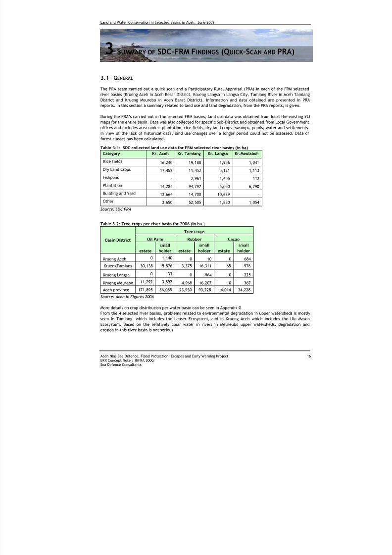
The PRA team carried out a quick scan and a Participatory Rural Appraisal (PRA) in each of the FRM selected
river basins (Krueng Aceh in Aceh Besar District, Krueng Langsa in Langsa City, Tamiang River in Aceh Tamiang
District and Krueng Meurebo in Aceh Barat District). Information and data obtained are presented in PRA
reports. In this section a summary related to land use and land degradation, from the PRA reports, is given.
During the PRA’s carried out in the selected FRM basins, land use data was obtained from local the existing YLI
maps for the entire basin. Data was also collected for specific Sub-District and obtained from Local Government
offices and includes area under: plantation, rice fields, dry land crops, swamps, ponds, water and settlements.
In view of the lack of historical data, land use changes over a longer period could not be assessed. Data of
forest classes has been calculated.
Table 3-1: SDC collected land use data for FRM selected river basins (in ha)
Category Kr. Aceh Kr. Tamiang Kr. Langsa Kr.Meulaboh
Rice fields 16,240 19,188 1,956 1,041
Dry Land Crops 17,452 11,452 5,121 1,113
Fishpond - 2,961 1,655 112
Plantation 14,284 94,797 5,050 6,790
Building and Yard 12,664 14,700 10,629 -
Other 2,650 52,505 1,830 1,054
Source: SDC PRA
Table 3-2: Tree crops per river basin for 2006 (in ha.)
Tree crops
Oil Palm Rubber CacaoBasin District
estate
small
holder estate
small
holder estate
small
holder
Krueng Aceh 0 1,140 0 10 0 684
KruengTamiang 30,138 15,876 3,375 16,311 65 976
Krueng Langsa 0 133 0 864 0 225
Krueng Meurebo 11,292 3,892 4,968 16,207 0 367
Aceh province 171,895 86,085 23,930 93,228 4,014 34,228
Source: Aceh in Figures 2006
More details on crop distribution per water basin can be seen in Appendix G
From the 4 selected river basins, problems related to environmental degradation in upper watersheds is mostly
seen in Tamiang, which includes the Leuser Ecosystem, and in Krueng Aceh which includes the Ulu Masen
Ecosystem. Based on the relatively clear water in rivers in Meureubo upper watersheds, degradation and
erosion in this river basin is not serious.
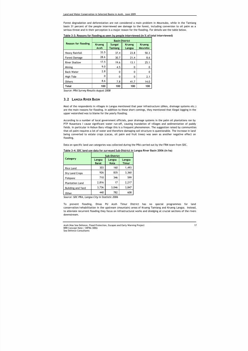
7/27/2019 Konservasi Air Dan Tanah Di Wilayah Sungai Terpilih Di Aceh
http://slidepdf.com/reader/full/konservasi-air-dan-tanah-di-wilayah-sungai-terpilih-di-aceh 27/70
Land and Water Conservation in Selected Basins in Aceh, June 2009
Aceh Nias Sea Defence, Flood Protection, Escapes and Early Warning Project 17BRR Concept Note / INFRA 300GISea Defence Consultants
Forest degradation and deforestation are not considered a main problem in Meureubo, while in the Tamiang
basin 31 percent of the people interviewed see damage to the forest, including conversion to oil palm as a
serious threat and in their perception is a major reason for the flooding. For details see the table below.
Table 3-3: Reasons for flooding as seen by people interviewed (in % of total interviewed)
Basin District
Reason for flooding Krueng
Aceh
Sungai
Tamiang
Krueng
Langsa
Krueng
Meurebo
Heavy Rainfall 33.5 37.4 23.8 50.3
Forest Damage 28.6 30.7 21.4 8.6
River Shallow 17.5 19.6 13.1 25.1
Mining 9.0 4.5 0 0
Back Water 2.8 0 0 0
High Tide 0 0 0 2.1
Others 8.6 7.8 41.7 14.0
Total 100 100 100 100Source: PRA Survey Results August 2008
3.2 LANGSA R IVER BASIN
Most of the respondents in villages in Langsa mentioned that poor infrastructure (dikes, drainage systems etc.)
are the main reasons for flooding. In addition to these short comings, they mentioned that illegal logging in the
upper watershed was to blame for the yearly flooding.
According to a number of local government officials, poor drainage systems in the palm oil plantations ran by
PTP Nusantara I cause significant water run-off, causing inundation of villages and sedimentation of paddy
fields. In particular in Kebun Baru village this is a frequent phenomenon. The suggestion raised by communities
that oil palm requires a lot of water and therefore damaging soil structure is questionable. The increase in landbeing converted to estate crops (cacao, oil palm and fruit trees) was seen as another negative effect on
flooding.
Data on specific land use categories was collected during the PRA carried out by the FRM team from SDC.
Table 3-4: SDC land use data for surveyed Sub-District in Langsa River Basin 2006 (in ha)
Sub-DistrictCategory Langsa
Barat
Langsa
Kota
Langsa
Timur
Rice Land 303 160 1,493
Dry Land Crops 926 835 3,360
Fishpond 710 346 599
Plantation Land 2,816 17 2,217
Building and Yard 3,736 3,046 3,847
Other 440 782 608
Source: SDC PRA, Langsa City in Statistic 2006
To prevent flooding, Dinas PU Aceh Timur District has no special programmes for land
conservation/rehabilitation in the upstream (mountain) areas of Krueng Tamiang and Krueng Langsa. Instead,
to alleviate recurrent flooding they focus on infrastructural works and dredging at crucial sections of the rivers
downstream.
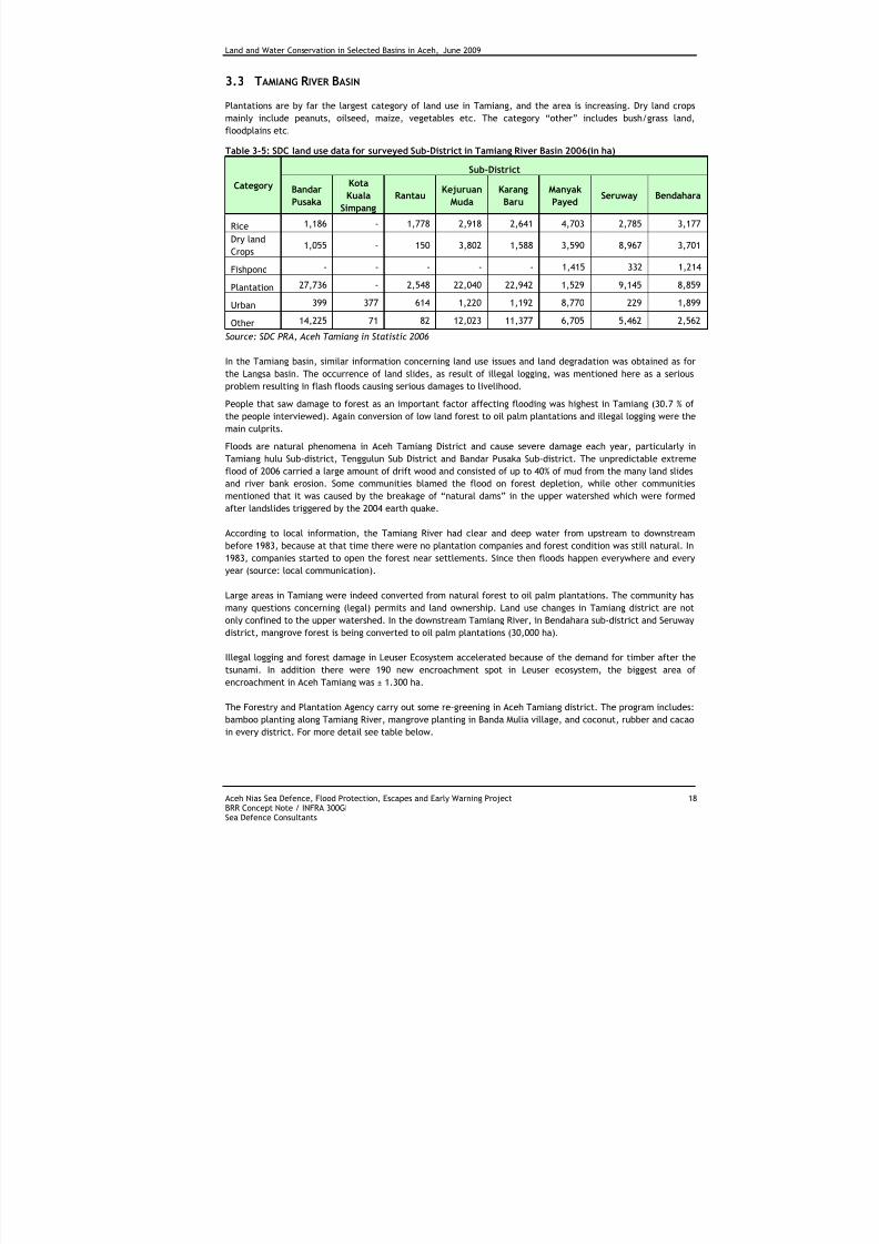
7/27/2019 Konservasi Air Dan Tanah Di Wilayah Sungai Terpilih Di Aceh
http://slidepdf.com/reader/full/konservasi-air-dan-tanah-di-wilayah-sungai-terpilih-di-aceh 28/70
Land and Water Conservation in Selected Basins in Aceh, June 2009
Aceh Nias Sea Defence, Flood Protection, Escapes and Early Warning Project 18BRR Concept Note / INFRA 300GISea Defence Consultants
3.3 TAMIANG R IVER BASIN
Plantations are by far the largest category of land use in Tamiang, and the area is increasing. Dry land crops
mainly include peanuts, oilseed, maize, vegetables etc. The category “other” includes bush/grass land,
floodplains etc.
Table 3-5: SDC land use data for surveyed Sub-District in Tamiang River Basin 2006(in ha)
Sub-District
Category Bandar
Pusaka
Kota
Kuala
Simpang
RantauKejuruan
Muda
Karang
Baru
Manyak
PayedSeruway Bendahara
Rice 1,186 - 1,778 2,918 2,641 4,703 2,785 3,177
Dry land
Crops1,055 - 150 3,802 1,588 3,590 8,967 3,701
Fishpond - - - - - 1,415 332 1,214
Plantation 27,736 - 2,548 22,040 22,942 1,529 9,145 8,859
Urban 399 377 614 1,220 1,192 8,770 229 1,899Other 14,225 71 82 12,023 11,377 6,705 5,462 2,562
Source: SDC PRA, Aceh Tamiang in Statistic 2006
In the Tamiang basin, similar information concerning land use issues and land degradation was obtained as for
the Langsa basin. The occurrence of land slides, as result of illegal logging, was mentioned here as a serious
problem resulting in flash floods causing serious damages to livelihood.
People that saw damage to forest as an important factor affecting flooding was highest in Tamiang (30.7 % of
the people interviewed). Again conversion of low land forest to oil palm plantations and illegal logging were the
main culprits.
Floods are natural phenomena in Aceh Tamiang District and cause severe damage each year, particularly in
Tamiang hulu Sub-district, Tenggulun Sub District and Bandar Pusaka Sub-district. The unpredictable extremeflood of 2006 carried a large amount of drift wood and consisted of up to 40% of mud from the many land slides
and river bank erosion. Some communities blamed the flood on forest depletion, while other communities
mentioned that it was caused by the breakage of “natural dams” in the upper watershed which were formed
after landslides triggered by the 2004 earth quake.
According to local information, the Tamiang River had clear and deep water from upstream to downstream
before 1983, because at that time there were no plantation companies and forest condition was still natural. In
1983, companies started to open the forest near settlements. Since then floods happen everywhere and every
year (source: local communication).
Large areas in Tamiang were indeed converted from natural forest to oil palm plantations. The community has
many questions concerning (legal) permits and land ownership. Land use changes in Tamiang district are not
only confined to the upper watershed. In the downstream Tamiang River, in Bendahara sub-district and Seruway
district, mangrove forest is being converted to oil palm plantations (30,000 ha).
Illegal logging and forest damage in Leuser Ecosystem accelerated because of the demand for timber after the
tsunami. In addition there were 190 new encroachment spot in Leuser ecosystem, the biggest area of
encroachment in Aceh Tamiang was ± 1.300 ha.
The Forestry and Plantation Agency carry out some re-greening in Aceh Tamiang district. The program includes:
bamboo planting along Tamiang River, mangrove planting in Banda Mulia village, and coconut, rubber and cacao
in every district. For more detail see table below.

7/27/2019 Konservasi Air Dan Tanah Di Wilayah Sungai Terpilih Di Aceh
http://slidepdf.com/reader/full/konservasi-air-dan-tanah-di-wilayah-sungai-terpilih-di-aceh 29/70
Land and Water Conservation in Selected Basins in Aceh, June 2009
Aceh Nias Sea Defence, Flood Protection, Escapes and Early Warning Project 19BRR Concept Note / INFRA 300GISea Defence Consultants
Table 3-6: Re-greening program of Forestry & Plantation Agency, 2008 in Tamiang (in ha)
Program Target Plants Location (Kecamatan) (ha)
Coconut
"Dalam"
Increasing
production
- Banda Mulia, Seuruway, Bendahara, Manyak
Payed
206
Cacao Increasing
production
40,000 Bendahara, Seuruway, Rantau and Kejuruan
Muda
40
Rubber Increasing
production
100,000 Karang Baru, Bandar Pusaka, Tamiang Hulu,
Tenggulun, Kejuruan Muda, Manyak Payed,
200
Rubber and
Cacao
Increasing
production
- Kejuruan Muda, Karang Baru, Bandar Pusaka,
Tamiang Hulu, Tenggulun, Manyak Payed,
Bendahara, Seuruway and Rantau
200 (rubber)
40 (cacao)
Palm Oil Increasing
production
22,500 Karang Baru, Manyak Payed, Tamiang Hulu,
Kejuruan Muda, Tenggulun and Bandar Pusaka
150
Coconut
"Dalam"
Increasing
production
25,750 Banda Mulia, Seuruway, Bendahara and
Manyak Payed
206
Mangrove Increasing
mangrove
area
200,000 Banda Mulia 40
Bamboo Reduce
erosion
riverbank
125,000 Alongside of DAS Tamiang -
Source: Aceh Tamiang Forestry and Plantation Agency 2008
Figure 3-1: Land slide- and Flash flood damage in the upper watershed of Tamiang Basin
3.4 K RUENG ACEH R IVER BASIN
In the Krueng Aceh river basin, causes of floods differ going from the upstream area to the downstream area. In
the upstream part of the river basin flash floods occur along the Krueng Inong and Krueng Agam caused by a
combination of heavy rainfall, deforestation in the upstream part of the basin and mining of river sand and
stone in river bed. Degradation of forest was noted in Seulawah Mountain.
Illegal sand mining exploration run by ex-combatant (GAM) people (previously KPA) is another problem that is
difficult to solve in Krueng Aceh. Most of the people in the villages affected by flood from Krueng Aceh blame
the floods on illegal sand mining.
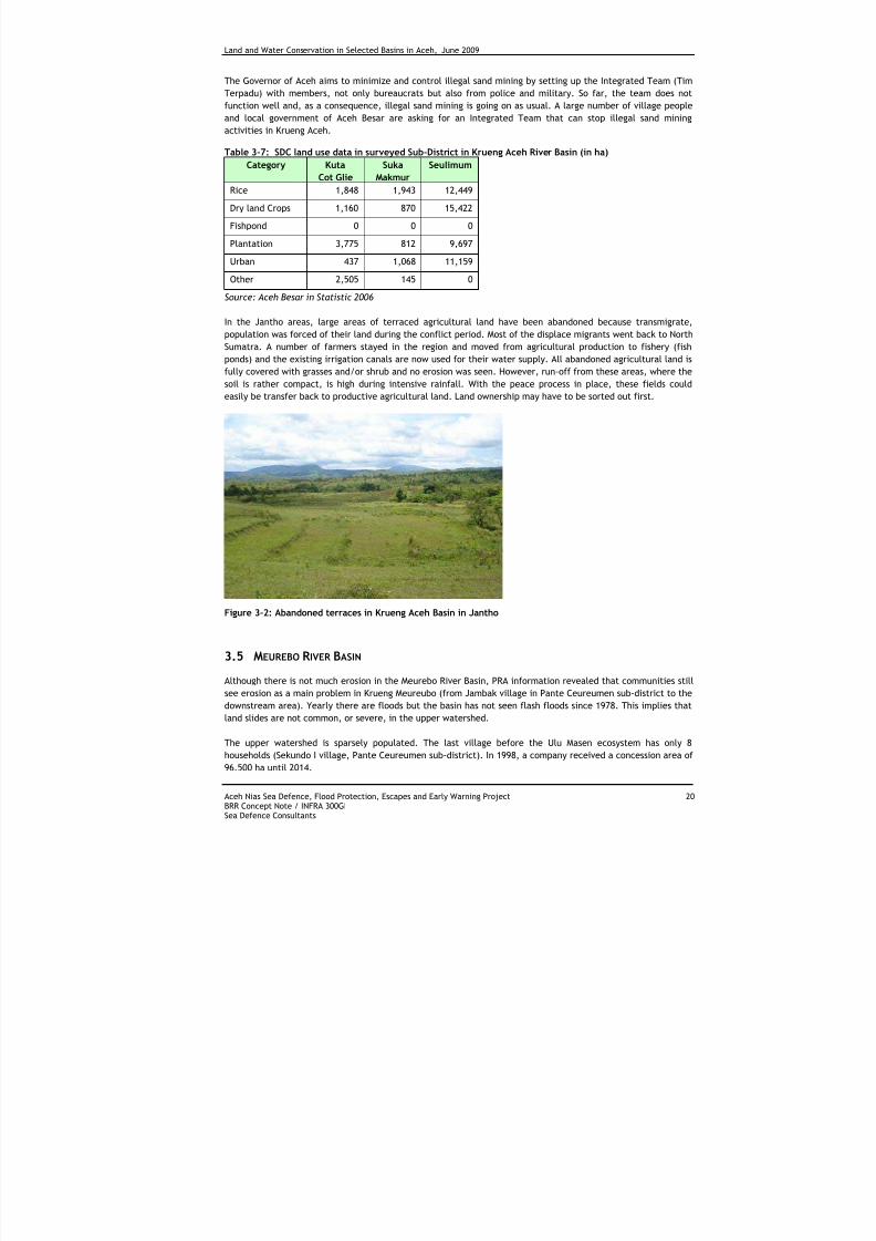
7/27/2019 Konservasi Air Dan Tanah Di Wilayah Sungai Terpilih Di Aceh
http://slidepdf.com/reader/full/konservasi-air-dan-tanah-di-wilayah-sungai-terpilih-di-aceh 30/70
Land and Water Conservation in Selected Basins in Aceh, June 2009
Aceh Nias Sea Defence, Flood Protection, Escapes and Early Warning Project 20BRR Concept Note / INFRA 300GISea Defence Consultants
The Governor of Aceh aims to minimize and control illegal sand mining by setting up the Integrated Team (Tim
Terpadu) with members, not only bureaucrats but also from police and military. So far, the team does not
function well and, as a consequence, illegal sand mining is going on as usual. A large number of village people
and local government of Aceh Besar are asking for an Integrated Team that can stop illegal sand mining
activities in Krueng Aceh.
Table 3-7: SDC land use data in surveyed Sub-District in Krueng Aceh River Basin (in ha)Category Kuta
Cot Glie
Suka
Makmur
Seulimum
Rice 1,848 1,943 12,449
Dry land Crops 1,160 870 15,422
Fishpond 0 0 0
Plantation 3,775 812 9,697
Urban 437 1,068 11,159
Other 2,505 145 0
Source: Aceh Besar in Statistic 2006
In the Jantho areas, large areas of terraced agricultural land have been abandoned because transmigrate,
population was forced of their land during the conflict period. Most of the displace migrants went back to North
Sumatra. A number of farmers stayed in the region and moved from agricultural production to fishery (fish
ponds) and the existing irrigation canals are now used for their water supply. All abandoned agricultural land is
fully covered with grasses and/or shrub and no erosion was seen. However, run-off from these areas, where the
soil is rather compact, is high during intensive rainfall. With the peace process in place, these fields could
easily be transfer back to productive agricultural land. Land ownership may have to be sorted out first.
Figure 3-2: Abandoned terraces in Krueng Aceh Basin in Jantho
3.5 MEUREBO R IVER BASIN
Although there is not much erosion in the Meurebo River Basin, PRA information revealed that communities still
see erosion as a main problem in Krueng Meureubo (from Jambak village in Pante Ceureumen sub-district to the
downstream area). Yearly there are floods but the basin has not seen flash floods since 1978. This implies that
land slides are not common, or severe, in the upper watershed.
The upper watershed is sparsely populated. The last village before the Ulu Masen ecosystem has only 8
households (Sekundo I village, Pante Ceureumen sub-district). In 1998, a company received a concession area of
96.500 ha until 2014.
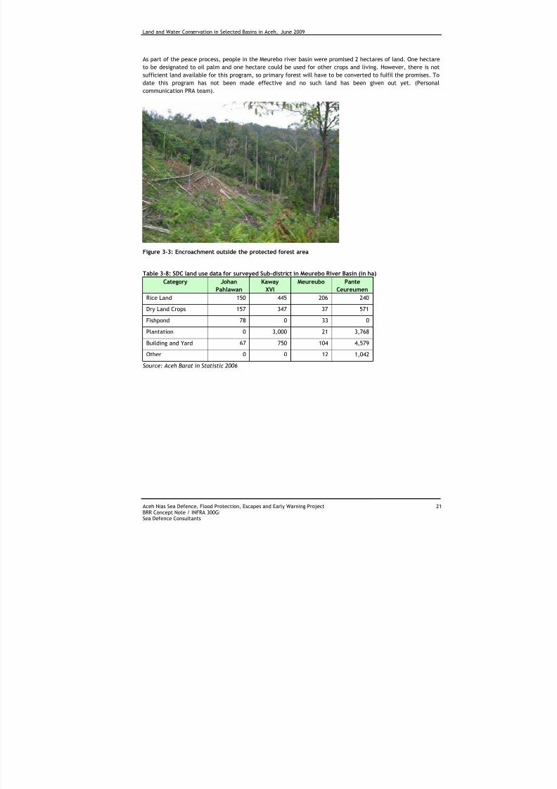
7/27/2019 Konservasi Air Dan Tanah Di Wilayah Sungai Terpilih Di Aceh
http://slidepdf.com/reader/full/konservasi-air-dan-tanah-di-wilayah-sungai-terpilih-di-aceh 31/70
Land and Water Conservation in Selected Basins in Aceh, June 2009
Aceh Nias Sea Defence, Flood Protection, Escapes and Early Warning Project 21BRR Concept Note / INFRA 300GISea Defence Consultants
As part of the peace process, people in the Meurebo river basin were promised 2 hectares of land. One hectare
to be designated to oil palm and one hectare could be used for other crops and living. However, there is not
sufficient land available for this program, so primary forest will have to be converted to fulfil the promises. To
date this program has not been made effective and no such land has been given out yet. (Personal
communication PRA team).
Figure 3-3: Encroachment outside the protected forest area
Table 3-8: SDC land use data for surveyed Sub-district in Meurebo River Basin (in ha)
Category Johan
Pahlawan
Kaway
XVI
Meureubo Pante
CeureumenRice Land 150 445 206 240
Dry Land Crops 157 347 37 571
Fishpond 78 0 33 0
Plantation 0 3,000 21 3,768
Building and Yard 67 750 104 4,579
Other 0 0 12 1,042
Source: Aceh Barat in Statistic 2006
7/27/2019 Konservasi Air Dan Tanah Di Wilayah Sungai Terpilih Di Aceh
http://slidepdf.com/reader/full/konservasi-air-dan-tanah-di-wilayah-sungai-terpilih-di-aceh 32/70
Land and Water Conservation in Selected Basins in Aceh, June 2009
Aceh Nias Sea Defence, Flood Protection, Escapes and Early Warning Project 22BRR Concept Note / INFRA 300GISea Defence Consultants
4 LAND CONSERVATION PROGRAMS IN INDONESIA
4.1 NATION WIDE LAND CONSERVATION PROGRAMMES
Over the last decades a number of land conservation and land use oriented programs have been initiated in
Indonesia. Most of these programs deal with activities and policies related to land degradation and protection
of forest area including re-forestation and re-greening. The major programs are:
- GERHAN
The National Reforestation Movement (GERHAN) started in 2003. The GERHAN program classifies degraded land
into 3 categories:
1st priority land (extremely degraded land) such as shrubs and bare land;
2nd priority land (degraded land) such as secondary forest and
3rd priority land: other land uses.
There are three patterns in the way the government is implementing GERHAN in 2007, the first is the full
subsidy pattern in which the government is responsible for handling all reforestation-related activities, the
second is the incentive pattern in which the public takes an active part in planting trees outside the designated
areas, and the third is the forest and bush rehabilitation pattern in which reforestation is conducted by
applying efficient technology and a management system.
Through GERHAN 2007, the government has set itself the target of preparing 4.4 million ha of arid and barren
land for reforestation. GERHAN programs are allocated to farmers as direct incentives (such as financial cash or
seedlings) to plant trees on their farms. Up to now, it is difficult to note the success of those programs.
Ministry of Forest in Aceh prepared a Data Base Book with summaries of GERHAN project and program locations
in NAD Province from 2004 until 2006.
The Reforestation and Regreening (R&R) Program, which was the Indonesian national soil conservation program
implemented on farmers’ land, has been incorporated in the GERHAN programme. On of the main reasons is
that little success has been achieved since its establishment in 1976. The lack of success was blamed on
institutional complexity, complicated planning procedures and especially, inappropriate selection of soil
conservation measures.
Regreening programs are implemented by MOF, ICRAF, NGO’s and some organisations dealing with carbon
credits. Most recent and ongoing re-forestation and regreening projects in Aceh province still focus on
rehabilitation of tsunami affected coastal areas.
- Reduce Emissions from Deforestation and forest Degradation (REDD)
A relative new program in Indonesia is REDD (Reduce Emissions from Deforestation and forest Degradation). The
program will likely be expanded to have five key sectors; forest conversion to oil palm, forest land-use change
for pulp and paper plantations, natural production forest management, protected area management and forests
and peat lands.
Indonesia has already started work to examine these and other issues of specific importance to the country.
The Ministry of Forestry formed the “Indonesian Forest Climate Alliance” (IFCA).
There are two main components to measuring and monitoring emissions from deforestation and degradation:
• Change in forest cover
• Change in forest area and
7/27/2019 Konservasi Air Dan Tanah Di Wilayah Sungai Terpilih Di Aceh
http://slidepdf.com/reader/full/konservasi-air-dan-tanah-di-wilayah-sungai-terpilih-di-aceh 33/70
Land and Water Conservation in Selected Basins in Aceh, June 2009
Aceh Nias Sea Defence, Flood Protection, Escapes and Early Warning Project 23BRR Concept Note / INFRA 300GISea Defence Consultants
• Reduction in forest cover
• Change in carbon stocks and in emissions of non-CO2 gases
Future oil palm projects should be developed on existing degraded lands to reduce (significant) carbon
emissions. REDD financing could potentially be deployed to cover the opportunity cost of not converting
forested lands and peat lands to oil palm.
- National Watershed Development Program
From 1993 until 2000, the National Watershed Development Program channelled around US$ 50 million annually
to provincial and district level governments in Indonesia for regreening and reforestation projects to control
erosion and floods and to increase people’s participation in conservation of natural resources. The program
uses soil conservation and farming demonstration units. Establishment of check dams for irrigation and re-
charge of ground water are also included in this programme.
- Five Year Plan on Forest and Land Rehabilitation Program (RHL-5 tahun)
In 2002, the Ministry initiated a policy under the umbrella of social forestry in the direction of community-
based rehabilitation programs. The technical plan was developed under the Five Year Plan on Forest and Land
Rehabilitation Program (RHL-5 tahun) using catchments areas as the unit of management. The first priority
category to be rehabilitated included 60 watersheds. However due to financial constraints, the program couldonly focus on rehabilitating 17 catchments areas over the five years. The program did not include Aceh
Province. The Forest and Rehabilitation Plan is the only recent nation wide project with focus on community
based land rehabilitation.
4.2 ACEH LAND CONSERVATION PROGRAMMES AND PROJECTS
There are a number of rehabilitation programs currently implemented in the tsunami affected coastal region of
Aceh. In addition to the civil engineering and housing projects, projects include integrated agriculture and
fisheries development, forestry and re-greening programs and soil improvement projects. This section focuses
on the larger programs/projects related to land conservation, land use and forestry in NAD.
4.2.1 Strategy
These programmes are designed within the context of the Aceh Green Development Strategy (Aceh Green):
To counter the effect of the withdrawal of many aid agencies in 2009, Aceh will require a different approach
towards land degradation, deforestation, and natural resource management. The Aceh Government has
therefore developed a vision for green economic development, which consists of eight main components spread
among three priority categories.
A. Land Use, Land Use Change and Forest (LUCF) Management
Component 1: Primary Forest Protection and Management
Component 2: Reforestation and Forest Restoration
Component 3: Community Forestry and Agro-forestry Development
B. Sustainable Economic Development
Component 4: Smallholder Estate Crop Development in Partnership with Private Sector and
Parastatal Estate Crops & Associated Infrastructure
Component 5: Spatial Planning, Management, and Development of Capture Fisheries and
Aquaculture
Component 6: Public Infrastructure Development
C. Renewable Green Energy
Component 7: Geothermal Energy
Component 8: Micro Hydro
7/27/2019 Konservasi Air Dan Tanah Di Wilayah Sungai Terpilih Di Aceh
http://slidepdf.com/reader/full/konservasi-air-dan-tanah-di-wilayah-sungai-terpilih-di-aceh 34/70
Land and Water Conservation in Selected Basins in Aceh, June 2009
Aceh Nias Sea Defence, Flood Protection, Escapes and Early Warning Project 24BRR Concept Note / INFRA 300GISea Defence Consultants
Aceh Green will integrate and expand carefully and consciously integrated themes of climate change via
renewable energy and land use management, community development, commerce and conservation. Aceh
Green will explore establishing an Aceh Green Fund to finance public-private partnerships dealing with
infrastructure programs, urban development, clean energy (including geothermal and hydropower), creation of
bio fuel feedstock, integrated land use program in tropical commodities (including, but not limited to coffee,
cocoa, palm oil and rubber), aquaculture and coastal artificial fisheries, reforestation (rainforest/mangroves)
and avoided deforestation.
In support of the Aceh Green Development Strategy, and consonant with the green growth approach to
developing environmentally sustainable economies, as promoted by ESCAP, the programme will also synergize
actions to improve human security in Aceh Province.
A Team of different experts are currently drafting the new forest policy.
4.2.2 Programmes and Projects
- Rehabilitation of Agricultural Systems in Aceh; Developing Nurseries of Excellence (NOEL)
The project was established in 2007 and is implemented by the World Agro forestry Centre (ICRAF) through
support from the Government of Canada (CIDA). The two year Program is designed to improve agro forestry in
the communities most affected by the 2004 tsunami by establishing mother nurseries. Given the large number
of internally displaced people in this region, there is potentially serious environmental impact arising from the
substantial increase in population density and increased pressure on agriculture, slopes, and forests. In this
context, there is a need to develop a Program for re-establishing and improving agro forestry in all communities
and watersheds that have been affected. The purpose of the Project is to rebuild and strengthen farmer’s
livelihoods and rehabilitate their lands by growing more productive tree crops using seedlings for the program’s
agro-forestry mother nurseries in the three most affected districts in Aceh: Aceh Barat, Aceh Jaya and Pidie.
All NOEL Program sites are located where fallow agricultural lands, tree gardens and government lands in need
of rehabilitation and therefore will not support forest conversion or resource degradation. The Program
excludes the promotion or support of oil palm establishment which is a main catalyst for forest conversion.
Seedling demand is highest for rubber and durian, followed by rambutan, cacao, and mango. Rubber is the
highest priority species in Aceh Barat and Aceh Jaya, accounting for 34% of seedling demand. In total the
project distributed over 550,000 seedlings in the first 9 months of the project.
- Aceh Forest and Environment Project
The project is implemented by Leuser International Foundation and Fauna Flora International over a period or
4.5 years (2006-2010). It is the largest forestry project funded by the WB in Indonesia .The project helps
protect the Leuser and Ulu Masen forest ecosystems from illegal logging and forest degradation. The protection
of the 3.3 million hectare area will help protect the water supply of 60% of the Acehnese population .
The project supports and strengthens governance mechanisms for forest protection and supports community
based forest and ecosystem rehabilitation by establishing community managed tree nurseries, supporting tree
planting and maintenance on degraded land and facilitating community assisted natural regeneration.
Community-based tree planting will focused on areas that have been severely degraded and/or have no
currently existing tree cover. Most of the locations selected in 2008 will be on community-owned lands lying on
the outer edge of the Leuser ecosystem; however, some locations will be on government land. Fourteen
community reforestation projects are planned for the LE area during 2008. At least 8 sites for natural
regeneration will be selected during 2008. Communities will be assessed how they can best protect their
upstream forests (implement fire-control measures; prevent unnecessary encroachment on recovering areas
etc.) .
In Geumpang (Pidie), FFI will develop a community-based forestry pilot project. It is expected that this
program will support conservation objectives and improve local livelihoods via the production of internationally
recognized certified timber and the harvesting of non-timber forest products.
7/27/2019 Konservasi Air Dan Tanah Di Wilayah Sungai Terpilih Di Aceh
http://slidepdf.com/reader/full/konservasi-air-dan-tanah-di-wilayah-sungai-terpilih-di-aceh 35/70
Land and Water Conservation in Selected Basins in Aceh, June 2009
Aceh Nias Sea Defence, Flood Protection, Escapes and Early Warning Project 25BRR Concept Note / INFRA 300GISea Defence Consultants
- The Integrating Environment and Forest Protection into the Recovery and Future Development of Aceh
Project
The Integrating Environment and Forest Protection into the Recovery and Future Development of Aceh Project
aims to protect critical environmental resources and services from the Leuser and Ulu Masen forest ecosystems
during the post-tsunami reconstruction process. The project has three main components:
- Component 1: Effective Protection and Sustainable Management of Leuser and Ulu Masen Forests. (Includes
governance, strengthen forest monitoring and protection systems and procedures, develop sustainable forest
and ecosystem management institutions).
- Component 2: Integration of Environmental Concerns into Aceh's Reconstruction and Development Planning
Process. (Includes activities designed to strengthen environmental and conservation considerations in spatial
planning, develop environmental and conservation education and awareness programs, and support
community based forest and ecosystem rehabilitation).
- Component 3: Effective and Transparent Project Implementation Support. (Includes activities is to strengthen
project governance, liaison, internal planning, monitoring and evaluation).
- Reducing Carbon Emissions from Deforestation in the Ulu Masen Ecosystem, Aceh, Indonesia
The (planned) project uses land use planning and reclassification, increased monitoring and law enforcement,
reforestation, restoration, and sustainable community logging on 750,000 ha of forest in the Ulu Masen
Ecosystem located in Aceh province. The project estimates proposed activities will reduce deforestation in the
area by 85% and 3,369,848 tons of CO2 emissions can be avoided each year.
Momentum is building behind Reduced Emissions from Deforestation and Degradation (REDD) initiatives to
extend carbon markets to “avoided deforestation” - activities that produce payments for preserving existing
forest. Early 2008 have seen the first rainforest project of this kind win independent validation to carbon
market accreditation standards in Indonesia.
The Indonesian project covers a 750,000 hectare (1.9m acres) swathe of the Ulu Masen forest in Sumatra’s Aceh
province. The provincial government claims the support of the local communities for a preservation operation
run by Fauna & Flora International and Carbon Conservation that would generate carbon credits for the
prevention of logging and clearing for palm oil plantations.
- Green Coast (BRR)
BRR green coast program is focusing only on monitoring and evaluation of the Re-planting Mangrove Program
that was/is implemented by NGOs and institutions participating in Tsunami Reconstruction and Rehabilitation
activities.
- Green Coast: For nature and people after the tsunami
This programme of Wetlands International, WWF, IUCN and Both ENDS has been active in Aceh since July 2005,
to rehabilitate livelihoods of the tsunami affected communities by restoring coastal ecosystems (coastal forest
and marine resources). Per March 2007, this resulted in 60 community led restoration projects, benefiting some
43,000 people and a total 600 hectares of coast successfully reforested with mangroves and other coastal
vegetation.
In April 2007, Oxfam/NOVIB approved another 1 million Euro funding from DEC in the UK for a second phase of
Green Coast in Aceh until December 2008. This follow up project focuses on the establishment of Green Coast
demonstration sites to show sustainable management solutions for coastal ecosystem degradation.
Green Coast Aceh partners WWF-Indonesia and Wetlands International Indonesia Program (WI-IP) work to
strengthen coastal resilience and sustainability of livelihoods in Aceh through establishment of 16 coastal
rehabilitation projects. Approximately 17,000 people will benefit from 530 hectares restored coastal forest and
strengthened natural buffer function and prevent further environmental damage. Green Coast Aceh network of
7/27/2019 Konservasi Air Dan Tanah Di Wilayah Sungai Terpilih Di Aceh
http://slidepdf.com/reader/full/konservasi-air-dan-tanah-di-wilayah-sungai-terpilih-di-aceh 36/70
Land and Water Conservation in Selected Basins in Aceh, June 2009
Aceh Nias Sea Defence, Flood Protection, Escapes and Early Warning Project 26BRR Concept Note / INFRA 300GISea Defence Consultants
civil society groups will be formed to increase information flow on threats to coastal ecosystems and on
reconstruction plans.
- Information Support for Management of Aceh’s Forest Resources - Spatial Planning and Environmental
Management Component
As part of the Earthquake and Tsunami Emergency Support Project (ADB), this project started in April 2008 andwill run until May 2009. The purpose of the project is to establish a GIS-based information system to support
forest management and to outline forest zoning recommendations and alternatives in Aceh Province It will
develop a decision support system for forest management resources to reduce degradation and maintain the
forest services.
The maps produces will show forest and adjacent land cover at appropriate scale. It will also identify fringe
areas where human activities may affect the management of forests. The GIS-based forest information system
will consist of baseline information concerning forest and other natural resources and the utilization which
affects them also it will contain land suitability and current land use assessment of current and planned forest
management policies, plans and programs In the long run the forest information system could become an
integrated part of the provincial natural resource management system including fisheries, agriculture mining
and the environment.
- Rebuilding Aceh based on the Aceh Green strategy: green growth, payments for ecosystem services and
climate action (planned)
The proposed projects will be funded by the Republic of Korea through the Environment and Sustainable
Development Division, ESCAP
Particularly with the withdrawal of many aid agencies in April 2009, Aceh will require private-public
partnerships, non-governmental oversight and private sector involvement to manage clean energy, bio fuel,
feedstock, and reforestation and avoid deforestation, all of which involve carbon and a commitment to green
development.”
The Aceh Government has therefore developed a vision for green economic development, which consists ofseven main components spread among three priority categories: Land use, land use change and forest
management; Sustainable Economic Development; and Renewable Green Energy.
- Compilation Report: Illegal Forest Activity - monitoring inside and around Leuser Ecosystem NAD
Province.
Monitoring of illegal logging activities was carried out by Leuser International Foundation over a period of 2, 5
years (Jan.2006–Jun. 2008). In this period, 5.091 cases of illegal activity were found inside and around the
Leuser Ecosystem in NAD province. These included 2.675 illegal logging cases/sites, 1996 land grabbing cases
and 3 cases of open mining. Most of the illegal logging took place in Aceh Selatan while grabbing of land was
most in Aceh Tenggara. The data gives useful information on actual locations and degree of illegal activities
within and around the Leuser Ecosystem. Details on distribution can be seen in Appendix F.
Based on the findings it was noted that the intensity of illegal logging activity increased each year. In 2006
there were 547 cases, in 2007 there were 1278 cases and in the first half year of 2008 there were already 850
cases.
There were 363 cases of encroachment into the Leuser Ecosystem NAD Province in 2006, in 2007 there were 869
cases and in the first half of 2008 164 cases were noted.
New open mining inside Leuser Ecosystem NAD province included gold mining, steel mines and stone mines
(marble). Mines were operated by village communities.
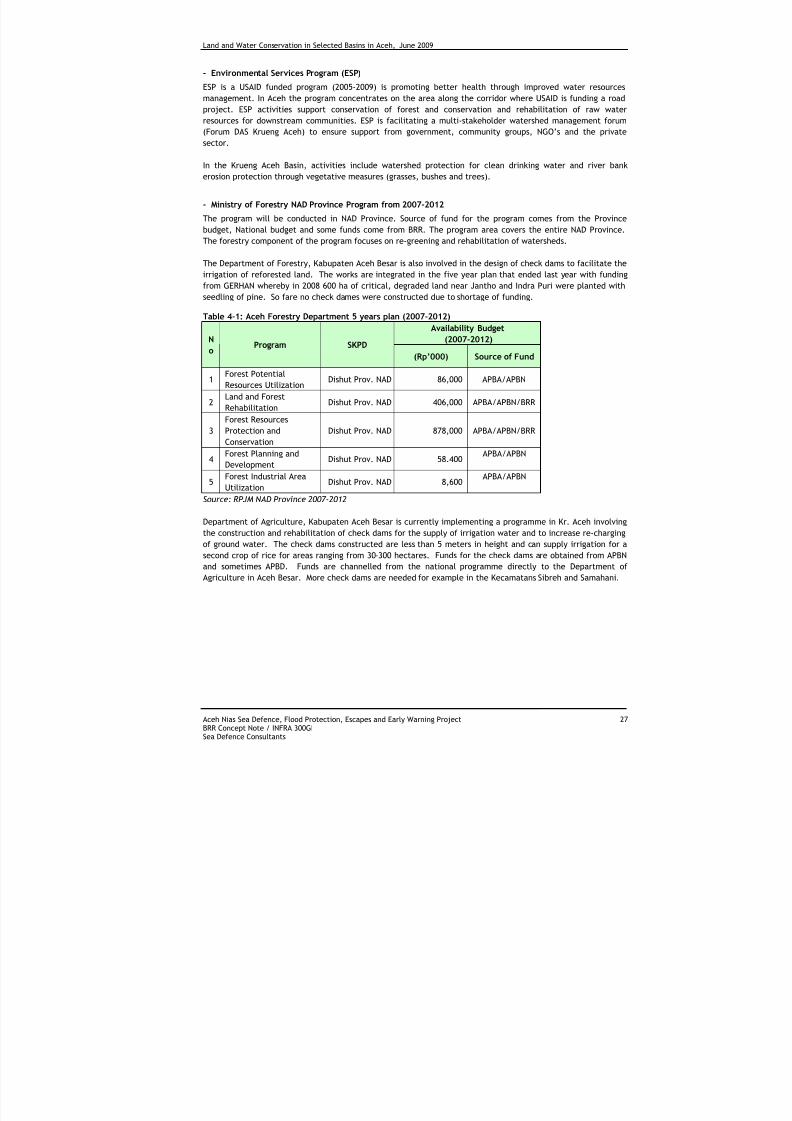
7/27/2019 Konservasi Air Dan Tanah Di Wilayah Sungai Terpilih Di Aceh
http://slidepdf.com/reader/full/konservasi-air-dan-tanah-di-wilayah-sungai-terpilih-di-aceh 37/70
Land and Water Conservation in Selected Basins in Aceh, June 2009
Aceh Nias Sea Defence, Flood Protection, Escapes and Early Warning Project 27BRR Concept Note / INFRA 300GISea Defence Consultants
- Environmental Services Program (ESP)
ESP is a USAID funded program (2005-2009) is promoting better health through improved water resources
management. In Aceh the program concentrates on the area along the corridor where USAID is funding a road
project. ESP activities support conservation of forest and conservation and rehabilitation of raw water
resources for downstream communities. ESP is facilitating a multi-stakeholder watershed management forum
(Forum DAS Krueng Aceh) to ensure support from government, community groups, NGO’s and the private
sector.
In the Krueng Aceh Basin, activities include watershed protection for clean drinking water and river bank
erosion protection through vegetative measures (grasses, bushes and trees).
- Ministry of Forestry NAD Province Program from 2007-2012
The program will be conducted in NAD Province. Source of fund for the program comes from the Province
budget, National budget and some funds come from BRR. The program area covers the entire NAD Province.
The forestry component of the program focuses on re-greening and rehabilitation of watersheds.
The Department of Forestry, Kabupaten Aceh Besar is also involved in the design of check dams to facilitate the
irrigation of reforested land. The works are integrated in the five year plan that ended last year with fundingfrom GERHAN whereby in 2008 600 ha of critical, degraded land near Jantho and Indra Puri were planted with
seedling of pine. So fare no check dames were constructed due to shortage of funding.
Table 4-1: Aceh Forestry Department 5 years plan (2007-2012)
Availability Budget
(2007-2012)N
oProgram SKPD
(Rp’000) Source of Fund
1Forest Potential
Resources UtilizationDishut Prov. NAD 86,000 APBA/APBN
2Land and Forest
RehabilitationDishut Prov. NAD 406,000 APBA/APBN/BRR
3
Forest Resources
Protection and
Conservation
Dishut Prov. NAD 878,000 APBA/APBN/BRR
4Forest Planning and
DevelopmentDishut Prov. NAD 58.400
APBA/APBN
5Forest Industrial Area
UtilizationDishut Prov. NAD 8,600
APBA/APBN
Source: RPJM NAD Province 2007-2012
Department of Agriculture, Kabupaten Aceh Besar is currently implementing a programme in Kr. Aceh involving
the construction and rehabilitation of check dams for the supply of irrigation water and to increase re-charging
of ground water. The check dams constructed are less than 5 meters in height and can supply irrigation for a
second crop of rice for areas ranging from 30-300 hectares. Funds for the check dams are obtained from APBNand sometimes APBD. Funds are channelled from the national programme directly to the Department of
Agriculture in Aceh Besar. More check dams are needed for example in the Kecamatans Sibreh and Samahani.
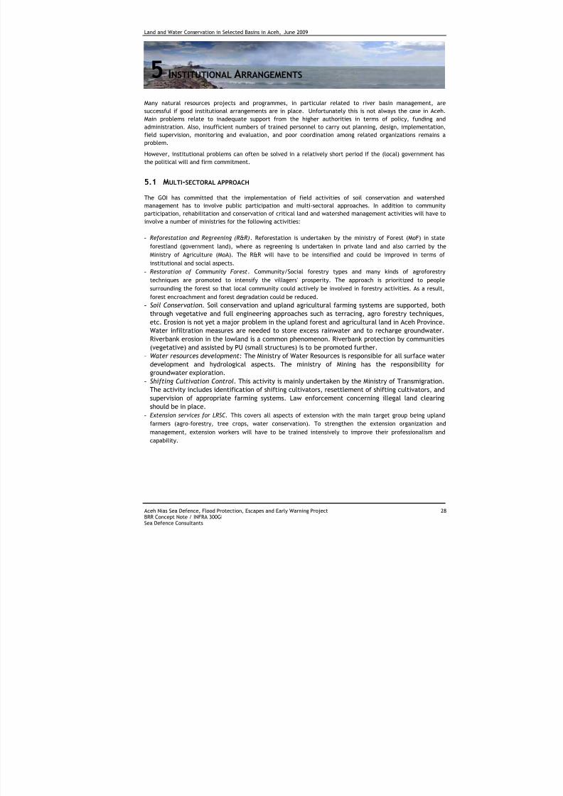
7/27/2019 Konservasi Air Dan Tanah Di Wilayah Sungai Terpilih Di Aceh
http://slidepdf.com/reader/full/konservasi-air-dan-tanah-di-wilayah-sungai-terpilih-di-aceh 38/70
Land and Water Conservation in Selected Basins in Aceh, June 2009
Aceh Nias Sea Defence, Flood Protection, Escapes and Early Warning Project 28BRR Concept Note / INFRA 300GISea Defence Consultants
5 INSTITUTIONAL ARRANGEMENTS
Many natural resources projects and programmes, in particular related to river basin management, are
successful if good institutional arrangements are in place. Unfortunately this is not always the case in Aceh.
Main problems relate to inadequate support from the higher authorities in terms of policy, funding and
administration. Also, insufficient numbers of trained personnel to carry out planning, design, implementation,
field supervision, monitoring and evaluation, and poor coordination among related organizations remains a
problem.
However, institutional problems can often be solved in a relatively short period if the (local) government has
the political will and firm commitment.
5.1 MULTI-SECTORAL APPROACH
The GOI has committed that the implementation of field activities of soil conservation and watershedmanagement has to involve public participation and multi-sectoral approaches. In addition to community
participation, rehabilitation and conservation of critical land and watershed management activities will have to
involve a number of ministries for the following activities:
- Reforestation and Regreening (R&R). Reforestation is undertaken by the ministry of Forest (MoF) in state
forestland (government land), where as regreening is undertaken in private land and also carried by the
Ministry of Agriculture (MoA). The R&R will have to be intensified and could be improved in terms of
institutional and social aspects.
- Restoration of Community Forest. Community/Social forestry types and many kinds of agroforestry
techniques are promoted to intensify the villagers' prosperity. The approach is prioritized to people
surrounding the forest so that local community could actively be involved in forestry activities. As a result,
forest encroachment and forest degradation could be reduced.- Soil Conservation. Soil conservation and upland agricultural farming systems are supported, both
through vegetative and full engineering approaches such as terracing, agro forestry techniques,
etc. Erosion is not yet a major problem in the upland forest and agricultural land in Aceh Province.Water infiltration measures are needed to store excess rainwater and to recharge groundwater.
Riverbank erosion in the lowland is a common phenomenon. Riverbank protection by communities
(vegetative) and assisted by PU (small structures) is to be promoted further.
- Water resources development: The Ministry of Water Resources is responsible for all surface water
development and hydrological aspects. The ministry of Mining has the responsibility forgroundwater exploration.
- Shifting Cultivation Control. This activity is mainly undertaken by the Ministry of Transmigration.The activity includes identification of shifting cultivators, resettlement of shifting cultivators, and
supervision of appropriate farming systems. Law enforcement concerning illegal land clearing
should be in place.
- Extension services for LRSC. This covers all aspects of extension with the main target group being upland
farmers (agro-forestry, tree crops, water conservation). To strengthen the extension organization and
management, extension workers will have to be trained intensively to improve their professionalism and
capability.
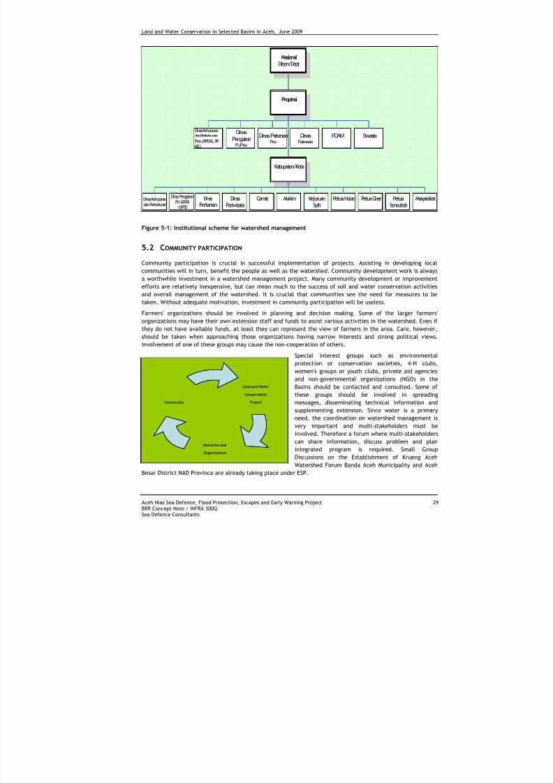
7/27/2019 Konservasi Air Dan Tanah Di Wilayah Sungai Terpilih Di Aceh
http://slidepdf.com/reader/full/konservasi-air-dan-tanah-di-wilayah-sungai-terpilih-di-aceh 39/70
Land and Water Conservation in Selected Basins in Aceh, June 2009
Aceh Nias Sea Defence, Flood Protection, Escapes and Early Warning Project 29BRR Concept Note / INFRA 300GISea Defence Consultants
Land and Water
Conservation
Project
Ministries and
Organisations
Community
NasionalDirjen/Dept
Propinsi
Kabupaten/Kota
Dinas
PertanianDinas
PariwisataCamat Mukim Kejuruan
SyihPetua Hutan Petua Glee Petua
SeneubokMasyarakatDinas Kehutanan
dan Perkebunan
Dinas PengairanPU (2009)/UPTD
DinasPariwisata
PDAM
Swasta
Dinas Kehutanandan PerkebunanProv.(BPDAS, BP-KEL)
Dinas
PengairanPUProv
Dinas PertanianProv
Figure 5-1: Institutional scheme for watershed management
5.2 COMMUNITY PARTICIPATION
Community participation is crucial in successful implementation of projects. Assisting in developing local
communities will in turn, benefit the people as well as the watershed. Community development work is always
a worthwhile investment in a watershed management project. Many community development or improvement
efforts are relatively inexpensive, but can mean much to the success of soil and water conservation activities
and overall management of the watershed. It is crucial that communities see the need for measures to be
taken. Without adequate motivation, investment in community participation will be useless.
Farmers' organizations should be involved in planning and decision making. Some of the larger farmers'
organizations may have their own extension staff and funds to assist various activities in the watershed. Even if
they do not have available funds, at least they can represent the view of farmers in the area. Care, however,
should be taken when approaching those organizations having narrow interests and strong political views.
Involvement of one of these groups may cause the non-cooperation of others.
Special interest groups such as environmental
protection or conservation societies, 4-H clubs,
women's groups or youth clubs, private aid agencies
and non-governmental organizations (NGO) in the
Basins should be contacted and consulted. Some ofthese groups should be involved in spreading
messages, disseminating technical information and
supplementing extension. Since water is a primary
need, the coordination on watershed management is
very important and multi-stakeholders must be
involved. Therefore a forum where multi-stakeholders
can share information, discuss problem and plan
integrated program is required. Small Group
Discussions on the Establishment of Krueng Aceh
Watershed Forum Banda Aceh Municipality and Aceh
Besar District NAD Province are already taking place under ESP.
7/27/2019 Konservasi Air Dan Tanah Di Wilayah Sungai Terpilih Di Aceh
http://slidepdf.com/reader/full/konservasi-air-dan-tanah-di-wilayah-sungai-terpilih-di-aceh 40/70
Land and Water Conservation in Selected Basins in Aceh, June 2009
Aceh Nias Sea Defence, Flood Protection, Escapes and Early Warning Project 30BRR Concept Note / INFRA 300GISea Defence Consultants
6 CONCLUDING NOTES
There is sufficient evidence that impact of land use on basin water resources in Aceh is of a different naturethan in the rest of Indonesia. In other parts of Indonesia water basin resources are primarily affected by the
need for more agricultural land, often on unsuitable land, and development of industries in the catchments
area. This result in high sediment loads in rivers and pollution of surface- and ground water. Until recently this
has been much less of a problem in Aceh. Pollution of water, by industrial development, is not likely to happen
soon in most of Aceh’s river basins. However, sedimentation of rivers exacerbated by increased logging and
conversion of forest to plantations (oil palm) is starting to become a serious concern, causes more sever
flooding, loss in agricultural production and livelihood.
The main change in land use currently affecting basin water resources in Aceh is a direct result of the need for
timber, sand, gravel and rock required for construction after the 2004 tsunami, and the peace agreement
signed in 2005 which opened the inland to new settlers and increased illegal logging activities. An Associated
Press report said that former Aceh rebels traded their guns for chain saws and were cashing in on a hugedemand for logs in Aceh's post-tsunami reconstruction.
Prior to these two events, Aceh was largely environmentally protected during a decade-long separatist
insurgency, with logging activities primarily limited to rebels and mischief elements within the military. Except
for particular areas where the war was worst corporate loggers could systematically clear forest and plant palm
oil after people were forced of their land.
As mentioned earlier, land use changes that have a significant negative effect on river basin resources are not
yet serious in Aceh Province. Over 60% of the area is under forest cover and population density and pressure on
the natural resources is still relatively low. However, given the rate of deforestation over the last couple of
years river basins may well be facing the negative effects of this change in land use soon. Illegal logging and
conversion of (mainly) low land forest to estate crops are the main culprits. Illegal logged lumber is not only
supplying the many construction activities in the tsunami affected west coast of Aceh, but is also transported
into bordering North Sumatra. Illegal logging induces land slides on steep hills with shallow soils (eg. In Tamiang
Basin) resulting in erosion and flash floods causing loss of life and serious damage to riverside communities.
It is interested to note that the degradation rate of forest in the Leuser Ecosystem reduced significantly during
the years 2000 – 2006 compared to the period 1990 – 2000. Although, damage to forest was mentioned as the
main cause of flooding, this does not necessary include damage to the Leuser System. In the Tamiang part of
the ecosystem, this went from 1570ha/year to 68ha/year. For the entire Leuser Ecosystem this went from
18,802ha/year to 6,278ha/year (see Appendix H). The likely cause of this reduction is the intensity of the
conflict in Aceh which was at its peak during the period 1998-2005. In 2005 the policy against legal logging was
enforced which may have contributed to the reduction in 2005 and 2006.
Most of the development of estate crops (mainly oil palm) took place in the Tamiang river basin. It is estimatedthat some 46.450 hectares of oil palm and cacao were planted in Tamiang, mostly on land converted from
forest. During the first year(s) of development, when the soil is still unprotected, there could be erosion and
increased water run-off. However, after ground cover crops are established, and after maturity of the trees,
erosion and run-off could be more or less the same as from the original forest. For well managed plantations on
areas that were converted from degraded forests on mineral soils, this could even be better than before.
Land use changes as a consequence of encroachment are slowly increasing in Aceh province. Following the
tsunami and with the peace agreement in place many people, including displaced persons by the tsunami, are
returning to the inland areas to return to coffee production such as in the Takengon area (USAID). Initially
neglected coffee kebuns are upgraded. As a consequence, limited land clearing has taken place so far. On the
other hand, it has been mentioned that there are also farmers leaving the hills to find better opportunities in
the rehabilitation activities along the coast (WB).
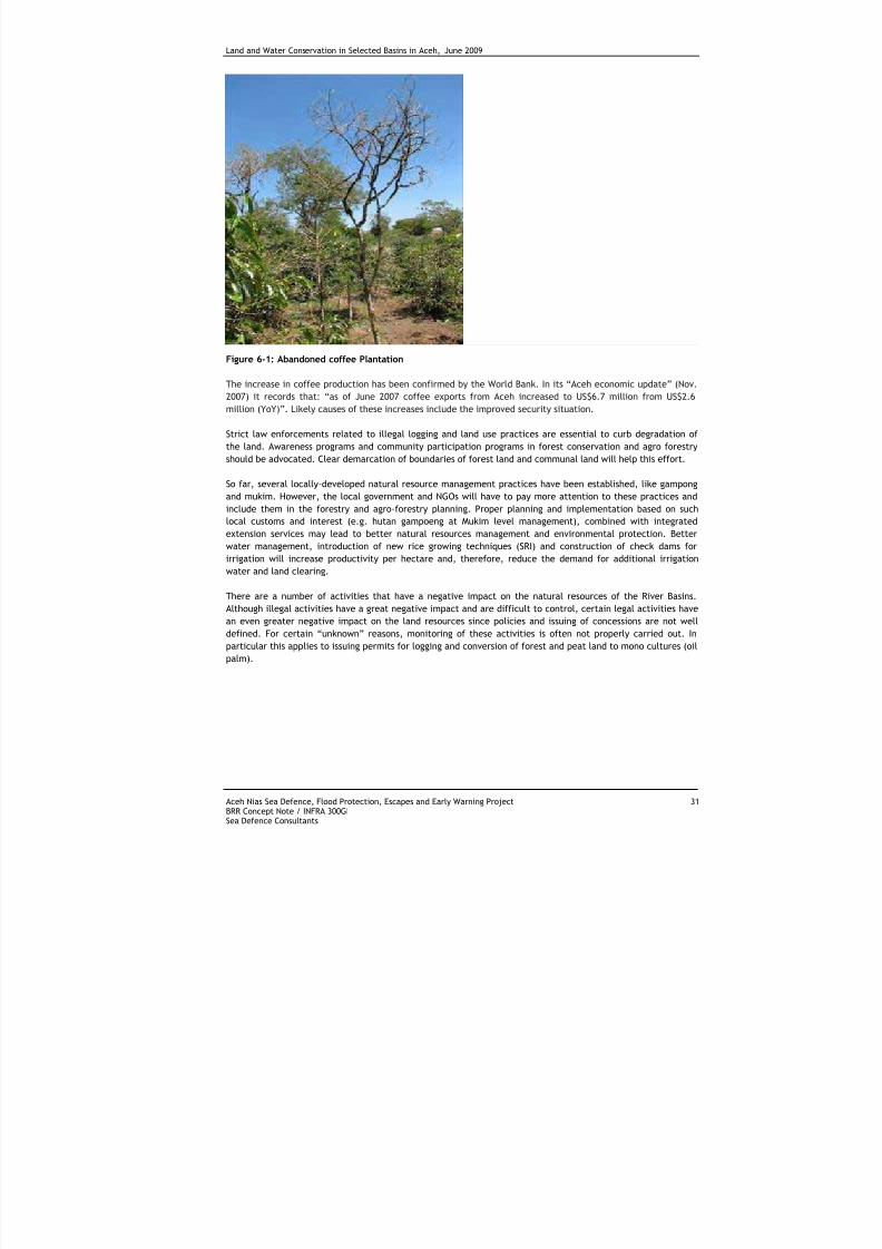
7/27/2019 Konservasi Air Dan Tanah Di Wilayah Sungai Terpilih Di Aceh
http://slidepdf.com/reader/full/konservasi-air-dan-tanah-di-wilayah-sungai-terpilih-di-aceh 41/70
Land and Water Conservation in Selected Basins in Aceh, June 2009
Aceh Nias Sea Defence, Flood Protection, Escapes and Early Warning Project 31BRR Concept Note / INFRA 300GISea Defence Consultants
Figure 6-1: Abandoned coffee Plantation
The increase in coffee production has been confirmed by the World Bank. In its “Aceh economic update” (Nov.
2007) it records that: “as of June 2007 coffee exports from Aceh increased to US$6.7 million from US$2.6
million (YoY)”. Likely causes of these increases include the improved security situation.
Strict law enforcements related to illegal logging and land use practices are essential to curb degradation of
the land. Awareness programs and community participation programs in forest conservation and agro forestry
should be advocated. Clear demarcation of boundaries of forest land and communal land will help this effort.
So far, several locally-developed natural resource management practices have been established, like gampong
and mukim. However, the local government and NGOs will have to pay more attention to these practices and
include them in the forestry and agro-forestry planning. Proper planning and implementation based on such
local customs and interest (e.g. hutan gampoeng at Mukim level management), combined with integrated
extension services may lead to better natural resources management and environmental protection. Better
water management, introduction of new rice growing techniques (SRI) and construction of check dams for
irrigation will increase productivity per hectare and, therefore, reduce the demand for additional irrigation
water and land clearing.
There are a number of activities that have a negative impact on the natural resources of the River Basins.
Although illegal activities have a great negative impact and are difficult to control, certain legal activities have
an even greater negative impact on the land resources since policies and issuing of concessions are not welldefined. For certain “unknown” reasons, monitoring of these activities is often not properly carried out. In
particular this applies to issuing permits for logging and conversion of forest and peat land to mono cultures (oil
palm).
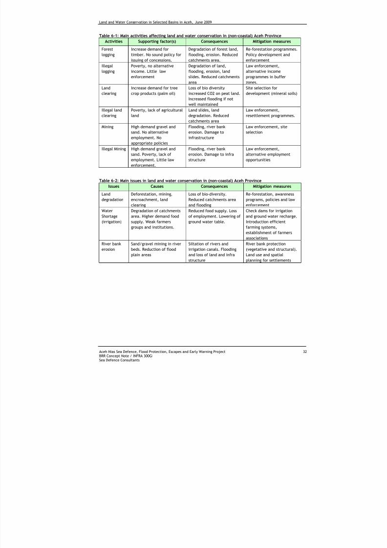
7/27/2019 Konservasi Air Dan Tanah Di Wilayah Sungai Terpilih Di Aceh
http://slidepdf.com/reader/full/konservasi-air-dan-tanah-di-wilayah-sungai-terpilih-di-aceh 42/70
Land and Water Conservation in Selected Basins in Aceh, June 2009
Aceh Nias Sea Defence, Flood Protection, Escapes and Early Warning Project 32BRR Concept Note / INFRA 300GISea Defence Consultants
Table 6-1: Main activities affecting land and water conservation in (non-coastal) Aceh Province
Activities Supporting factor(s) Consequences Mitigation measures
Forest
logging
Increase demand for
timber. No sound policy for
issuing of concessions.
Degradation of forest land,
flooding, erosion. Reduced
catchments area.
Re-forestation programmes.
Policy development and
enforcement
Illegallogging Poverty, no alternativeincome. Little law
enforcement
Degradation of land,flooding, erosion, land
slides. Reduced catchments
area
Law enforcement,alternative income
programmes in buffer
zones.
Land
clearing
Increase demand for tree
crop products (palm oil)
Loss of bio diversity
increased CO2 on peat land.
Increased flooding if not
well maintained
Site selection for
development (mineral soils)
Illegal land
clearing
Poverty, lack of agricultural
land
Land slides, land
degradation. Reduced
catchments area
Law enforcement,
resettlement programmes.
Mining High demand gravel and
sand. No alternative
employment. No
appropriate policies
Flooding, river bank
erosion. Damage to
infrastructure
Law enforcement, site
selection
Illegal Mining High demand gravel and
sand. Poverty, lack of
employment. Little law
enforcement.
Flooding, river bank
erosion. Damage to infra
structure
Law enforcement,
alternative employment
opportunities
Table 6-2: Main issues in land and water conservation in (non-coastal) Aceh Province
Issues Causes Consequences Mitigation measures
Land
degradation
Deforestation, mining,
encroachment, land
clearing
Loss of bio-diversity.
Reduced catchments area
and flooding
Re-forestation, awareness
programs, policies and law
enforcement
Water
Shortage
(irrigation)
Degradation of catchments
area. Higher demand food
supply. Weak farmers
groups and institutions.
Reduced food supply. Loss
of employment. Lowering of
ground water table.
Check dams for irrigation
and ground water recharge.
Introduction efficient
farming systems,
establishment of farmers
associations
River bank
erosion
Sand/gravel mining in river
beds. Reduction of flood
plain areas
Siltation of rivers and
irrigation canals. Flooding
and loss of land and infra
structure
River bank protection
(vegetative and structural).
Land use and spatial
planning for settlements
7/27/2019 Konservasi Air Dan Tanah Di Wilayah Sungai Terpilih Di Aceh
http://slidepdf.com/reader/full/konservasi-air-dan-tanah-di-wilayah-sungai-terpilih-di-aceh 43/70
Land and Water Conservation in Selected Basins in Aceh, June 2009
Aceh Nias Sea Defence, Flood Protection, Escapes and Early Warning Project 33BRR Concept Note / INFRA 300GISea Defence Consultants
7 R ECOMMENDATIONS FOR PROGRAMMES IN SDC BASINS
A recent study revealed that about 54% of the district population lives inland and nearly 94% of the inlandpopulation rely on agriculture compared to 55% in the coastal areas (ICRAF 2008). Yet, there is a little
development effort being directed towards the development of inland Aceh and hardly any (applied) research
and development related to tree crops, the environment-livelihood linkages and land-water linkages.
During the planning process, it is of utmost importance to gain political support. This will greatly enhance the
chance on actual implementation of projects, since the politicians are the ultimate decision makers influencing
budget allocations and preparing policies and legislation. Policies should match National and Provincial
development objectives and intergovernmental coordination is fundamental to river basin management
projects. A multi sectoral approach to planning and implementation of project will enhance the success of the
projects.
Reforestation, regreening and land conservation projects are too small and often cover a few hundred hectaresat the most. Larger long-term integrated projects are needed with multipurpose extension centres for
watershed management. Especially in the Tamiang river basin, such a project would improve livelihood and
therefore reduce encroachment into forest land, have a positive impact on the amount of illegal logging and
overall degradation of the watershed.
Environmental programs that also address the needs of the local people are more desirable and likely to
succeed than those providing mere protection functions. A focus on trees and tree-based systems, and how
such forest and agro-forest systems should be managed, is essential in reaching the objectives of livelihood
development with sustainable land use systems in Aceh Province.
Understanding of local customs is needed to deal with constraints and to make use of opportunities. Therefore,
programs should rely heavily on local customs and interest and should, where realistic, follow local
management systems (e.g. hutan gampoeng at Mukim level management). This will lead to better
understanding of environmental limitations and appropriate land use systems by stakeholders.
On degraded land, farming systems based on tree crops should be further promoted. Depending on the area
and cultural background of communities, a number of tree crops are grown. (Areca nut, cacao, coffee, coco
nut, rubber and oil palm). In particular cacao has become very popular. The crop can easily be managed by
women and the current prices for cacao are good.
Future programs should be based on an integrated watershed approach involving all stakeholders. To have the
best impact of such programs on soil/water conservation and living standards, multipurpose extension services
should be established. Farming systems including agro-forestry and multi-storey cropping will give farmers
adequate income opportunities from the start.
In particular in the uplands of the Krueng Aceh Basin lack of sufficient irrigation water is the main reason whyno double cropping is carried out. Water conservation could be carried out using a number of soil and water
conservation techniques that recharge ground water aquifers and store surface water for irrigation. Earthen
ponds, reservoirs and small check dams (embung) could be build.
Closer cooperation between the Departments of Agriculture, Planning and Public Works at Kabupaten Aceh
Besar would give Public Works the opportunity to embark on the construction of check dams for water supply of
a second crop for areas under development by Agriculture. BAPPEDA could facilitate in the planning and Public
Works could assist in supervising the design and construction of such larger infrastructure. The process will
enhance cross sectoral coordination between these Departments.
7/27/2019 Konservasi Air Dan Tanah Di Wilayah Sungai Terpilih Di Aceh
http://slidepdf.com/reader/full/konservasi-air-dan-tanah-di-wilayah-sungai-terpilih-di-aceh 44/70
Land and Water Conservation in Selected Basins in Aceh, June 2009
Aceh Nias Sea Defence, Flood Protection, Escapes and Early Warning Project 34BRR Concept Note / INFRA 300GISea Defence Consultants
Likewise the same coordination could possibly be established between the Departments of Forestry, Planning
and Public Works at Kabupaten Aceh Besar where Forestry is implementing reforestation on degraded, critical
lands.
The possibility to include generation of carbon credits into the programs should be investigated. Flora & Fauna
Int. and Carbon Conservation have already prepared a project design for such programs making use of “Reduced
Emissions from Deforestation and Degradation” (REDD) initiatives to extend carbon markets to “avoidingdeforestation” activities such as logging and clearing for palm oil plantations. Preliminary budget calculations
for the project allow for local communities around Ulu – Masen ecosystem to receive $26 million in the first five
years of the envisaged 30-year project. This would be their share of the carbon credits generated for the
avoided emissions.
Offering land use rights to villagers should be investigated as a realistic option to make full use of degraded
land. Hardwood seedlings for planting should be provided and villagers should be allowed to harvest the wood
at a given size. Contacts should be signed by villagers binding them to maintenance of the land and trees.
Tamiang and Langsa river basins are the most suitable basins to start land rehabilitation projects. Regreening
programmes involving agro forestry and tree crops etc., in buffer zones along forest areas will create income
opportunities and discourage illegal logging. In addition to land conservation programs in the Kr. Aceh Basin,
water conservation programs should be promoted to increase agricultural production and to recharge groundwater.
7/27/2019 Konservasi Air Dan Tanah Di Wilayah Sungai Terpilih Di Aceh
http://slidepdf.com/reader/full/konservasi-air-dan-tanah-di-wilayah-sungai-terpilih-di-aceh 45/70
Land and Water Conservation in Selected Basins in Aceh, June 2009
Aceh Nias Sea Defence, Flood Protection, Escapes and Early Warning Project 35BRR Concept Note / INFRA 300GISea Defence Consultants
LIST OF R EFERENCES
[1] ADB (Asian Development Bank), 2008Indonesia: Earthquake and Tsunami Emergency Support Project (Spatial Planning and
Environmental Management Component)
[2] Beria Leimona, Hendrayanto, Joko Prihatno, Nanang Roffandi, 2007
Financig mechanism for sustainable forest management in Indonesia: the role of public
financing instrument
[3] BRR NAD-Nias, PT. Geotrav Bhuana Survey, 2006
Kajian Pengembangan Sumberdaya Pesisir dan Laut Pantai Timur dan Pantai Barat Provinsi
Nanggroe Aceh Darussalam (Pasca Tsunami)
[4] BRR NAD-Nias, Dinas Kehutanan Provinsi NAD, BKSDA, BP DAS Provinsi NAD, Unsyiah, UNDP,
CENTRALs, 2008
Pengendalian Pembangunan Lingkungan dan Konservasi di NAD- Nias dalam Rangka
Perwujudan Kebijakan “Green Province”
[5] BRR NAD-Nias, 2008
Maps Album Pengendalian Kegiatan Rehabilitasi Mangrove and Hutan Pantai di Kawasan
Pesisir Nanggroe Aceh Darussalam.
[6] BRR NAD-Nias, 2008
Pengendalian Kegiatan Rehabilitasi Hutan Mangrove dan Hutan Pantai di Pesisir Nanggroe
Aceh Darussalam
[7] Dr. Sutardi, 2006Action Report toward Flood Disaster Reduction Indonesian Case
[8] Fahmuddin Agus, 2002
Selection of Soil Conservation Measures in The Indonesian Regreening Program
[9] FFI (Flora Fauna International), 2007-2008
Ulu Masen Hutan dan Iklim Bulletin
[10] IFCA (International Forest Climate Alliance), 2007
Reducing Emissions from Deforestation and Forest Degradations in Indonesia
[11] Laxman Joshi, Suseno Budidarsono and Ery Nugraha(2008)
Economic and Environmental Challenges in the post-Tsunami Post-Conflict Coast Land and
Upland in Aceh and Nias. (ICRAF)
[12] Masakazu Ichimura, Hitomi Rankine, UNESCAP(United Nations Economic and Social
Commission for Asia and the pacific), 2008
Rebuilding Aceh based on the Aceh Green strategy: green growth, payments for ecosystem
services and climate action
[13] NAD Province Program – BPDAS, 2008
Data Base Book Ministry of Forest GERHAN. Gerhan projects and program locations in NAD
Province from 2004 until 2006
7/27/2019 Konservasi Air Dan Tanah Di Wilayah Sungai Terpilih Di Aceh
http://slidepdf.com/reader/full/konservasi-air-dan-tanah-di-wilayah-sungai-terpilih-di-aceh 46/70
Land and Water Conservation in Selected Basins in Aceh, June 2009
Aceh Nias Sea Defence, Flood Protection, Escapes and Early Warning Project 36BRR Concept Note / INFRA 300GISea Defence Consultants
[14] Roshetko, JM, N. Idris, P. Purnomosidhi, T. Zulfadhli, and J. Tarigan. 2007. Rehabilitation
of Agricultural Systems in Aceh Developing Nurseries of Excellence (NOEL): Semi-Annual
Report 2007. The World Agroforestry Centre (ICRAF) and Winrock International. Bogor,
Indonesia. 19 p, plus appendices.
[15] Saeful Rahman, 2002
Forest Management Related to Water Conservation in Indonesia.
[16] Sonya Dewi, Andree Ekadinata, 2006
Resilience, Rights and Resources: Two years of Recovery in Coastal zone Aceh – Village
level analyses of poverty and land use/cover in West Village Aceh
[17] Stefano Pagiola, Environment Department, World Bank, 2000
Land Use Change in Indonesia
[18] Suseno Budidarsono1, Yuliana C. Wulan2, Budi3, Laxman Joshi4 and Sinung Hendratno5,
2007
Livelihoods and Forest Resources in Aceh and Nias for a Sustainable Forest Resource
Management and Economic Progress.Working Paper
[19] The Provincial Government of Nanggroe Aceh Darussalam, Flora Fauna International,
Carbon Conservation Pty. Ltd, 2007
Reducing Carbon Emissions from Deforestation in the Ulu Masen Ecosystem, Aceh,
Indonesia ~ A Triple-Benefit Project Design Note for CCBA Audit~
[20] Wetlands International, WWF (World Wildlife Fund), Both ENDS, IUCN, 2007
Dokumen Analisis Kebijakan Pengelolaan Sumber Daya Kelautan dan Perikanan Nanggroe Aceh
Darussalam. Green Coast for Nature and people after Tsunami
[21] World Bank, 2006
Sustaining Indonesia’s Forest Strategy for the World Bank 2006-2009
[22] Yayan Indriatmoko, Hasantoha Adnan, Heru Komarudin, Yulia Siagian, 2006
Resilience, Rights and Resources: Two years of Recovery in Coastal zone Aceh – Tsunami,
conflicts and forestry in Aceh: A brief review
[23] YLI (Yayasan Leuser International), MDF (Multi Donor Fund), 2008
Laporan Kompilasi Pemantauan Aktifitas Illegal Kehutanan Di Dalam dan Sekitar Kawasan Ekosistem
Leuser Provinsi Nanggroe Aceh Darussalam
7/27/2019 Konservasi Air Dan Tanah Di Wilayah Sungai Terpilih Di Aceh
http://slidepdf.com/reader/full/konservasi-air-dan-tanah-di-wilayah-sungai-terpilih-di-aceh 47/70
Land and Water Conservation in Selected Basins in Aceh, June 2009
Aceh Nias Sea Defence, Flood Protection, Escapes and Early Warning Project 37BRR Concept Note / INFRA 300GISea Defence Consultants
Colophon
Name of organisation Sea Defence Consultants
Name of projectAceh Nias Sea Defence, Flood Protection, Escapes and Early Warning
Project, (BRR Concept Note / INFRA 300GI)
Title of document Land and Water Conservation in Selected Basins in Aceh
Registration number SDC-R-90086
Document version June 2009
Author Jan Zonneveld, Cut Endah Setya Handayaningsih
Contributors Raden Krismahadianto, Alex Hamming
Team leader Bram van der Boon
7/27/2019 Konservasi Air Dan Tanah Di Wilayah Sungai Terpilih Di Aceh
http://slidepdf.com/reader/full/konservasi-air-dan-tanah-di-wilayah-sungai-terpilih-di-aceh 48/70
Land and Water Conservation in Selected Basins in Aceh, June 2009
Aceh Nias Sea Defence, Flood Protection, Escapes and Early Warning Project 38BRR Concept Note / INFRA 300GISea Defence Consultants
LIST OF APPENDICES
Appendix A - List of Available Land Use Maps at SDC ................................. 39
Appendix B - Maps ............................................................................ 50
Appendix C - Land Use Area per District/City 2006 ................................... 54
Appendix D - Type and Illegal Activity Cases............................................ 56
Appendix E - Forest Cover Change in Leuser Ecosystem............................. 58
Appendix F - Planted Area and Production in NAD .................................... 59
7/27/2019 Konservasi Air Dan Tanah Di Wilayah Sungai Terpilih Di Aceh
http://slidepdf.com/reader/full/konservasi-air-dan-tanah-di-wilayah-sungai-terpilih-di-aceh 49/70
Land and Water Conservation in Selected Basins in Aceh, June 2009
Aceh Nias Sea Defence, Flood Protection, Escapes and Early Warning Project 39BRR Concept Note / INFRA 300GISea Defence Consultants
Appendix A - LIST OF AVAILABLE LAND USE MAPS AT SDC
7/27/2019 Konservasi Air Dan Tanah Di Wilayah Sungai Terpilih Di Aceh
http://slidepdf.com/reader/full/konservasi-air-dan-tanah-di-wilayah-sungai-terpilih-di-aceh 50/70
7/27/2019 Konservasi Air Dan Tanah Di Wilayah Sungai Terpilih Di Aceh
http://slidepdf.com/reader/full/konservasi-air-dan-tanah-di-wilayah-sungai-terpilih-di-aceh 51/70
7/27/2019 Konservasi Air Dan Tanah Di Wilayah Sungai Terpilih Di Aceh
http://slidepdf.com/reader/full/konservasi-air-dan-tanah-di-wilayah-sungai-terpilih-di-aceh 52/70
7/27/2019 Konservasi Air Dan Tanah Di Wilayah Sungai Terpilih Di Aceh
http://slidepdf.com/reader/full/konservasi-air-dan-tanah-di-wilayah-sungai-terpilih-di-aceh 53/70
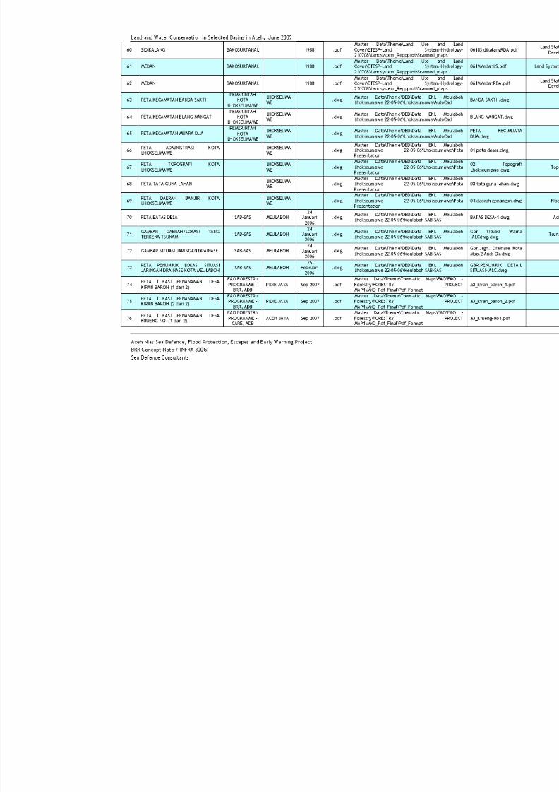
7/27/2019 Konservasi Air Dan Tanah Di Wilayah Sungai Terpilih Di Aceh
http://slidepdf.com/reader/full/konservasi-air-dan-tanah-di-wilayah-sungai-terpilih-di-aceh 54/70
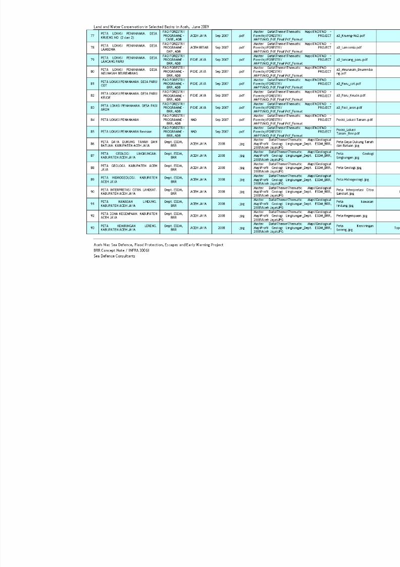
7/27/2019 Konservasi Air Dan Tanah Di Wilayah Sungai Terpilih Di Aceh
http://slidepdf.com/reader/full/konservasi-air-dan-tanah-di-wilayah-sungai-terpilih-di-aceh 55/70
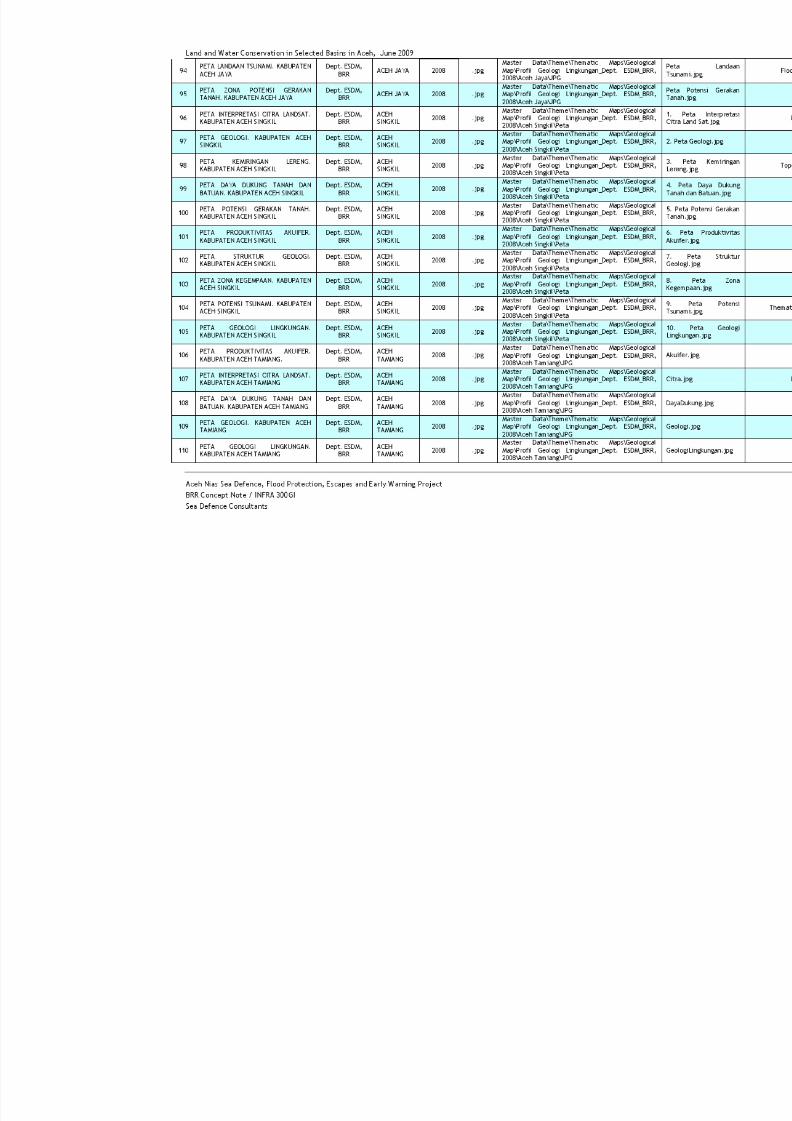
7/27/2019 Konservasi Air Dan Tanah Di Wilayah Sungai Terpilih Di Aceh
http://slidepdf.com/reader/full/konservasi-air-dan-tanah-di-wilayah-sungai-terpilih-di-aceh 56/70
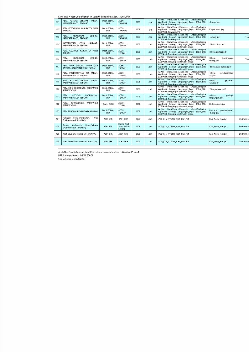
7/27/2019 Konservasi Air Dan Tanah Di Wilayah Sungai Terpilih Di Aceh
http://slidepdf.com/reader/full/konservasi-air-dan-tanah-di-wilayah-sungai-terpilih-di-aceh 57/70
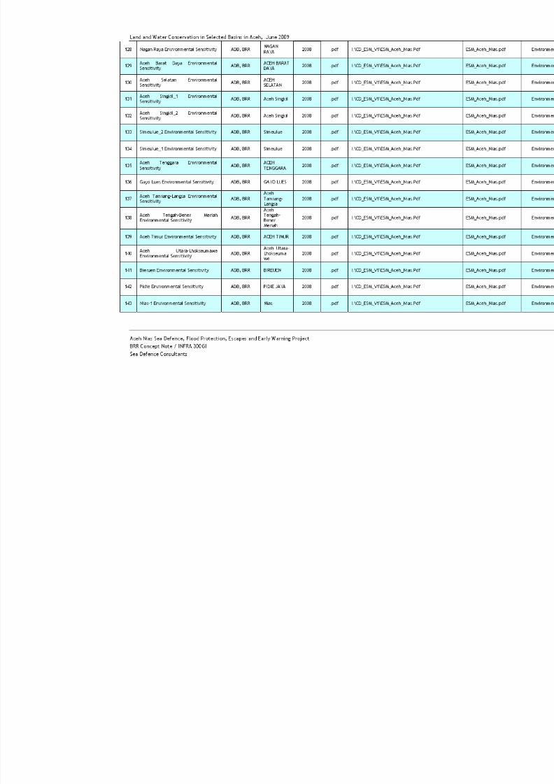
7/27/2019 Konservasi Air Dan Tanah Di Wilayah Sungai Terpilih Di Aceh
http://slidepdf.com/reader/full/konservasi-air-dan-tanah-di-wilayah-sungai-terpilih-di-aceh 58/70

7/27/2019 Konservasi Air Dan Tanah Di Wilayah Sungai Terpilih Di Aceh
http://slidepdf.com/reader/full/konservasi-air-dan-tanah-di-wilayah-sungai-terpilih-di-aceh 59/70
Land and Water Conservation in Selected Basins in Aceh, June 2009
Aceh Nias Sea Defence, Flood Protection, Escapes and Early Warning Project
BRR Concept Note / INFRA 300GI
Sea Defence Consultants
144 Nias-2 Environmental Sensitivity ADB, BRR Nias 2008 .pdf I:\CD_ESM_V1\ESM_Aceh_Nias.Pdf ESM
145 Nias-3 Environmental Sensitivity ADB, BRR Nias 2008 .pdf I:\CD_ESM_V1\ESM_Aceh_Nias.Pdf ESM
146Nanggroe Aceh DarussalamEnvironmental Sensitivity
ADB, BRRNADPROVINCE
2008 .pdf I:\CD_ESM_V1\ESM_Aceh_DnR.Pdf ESM
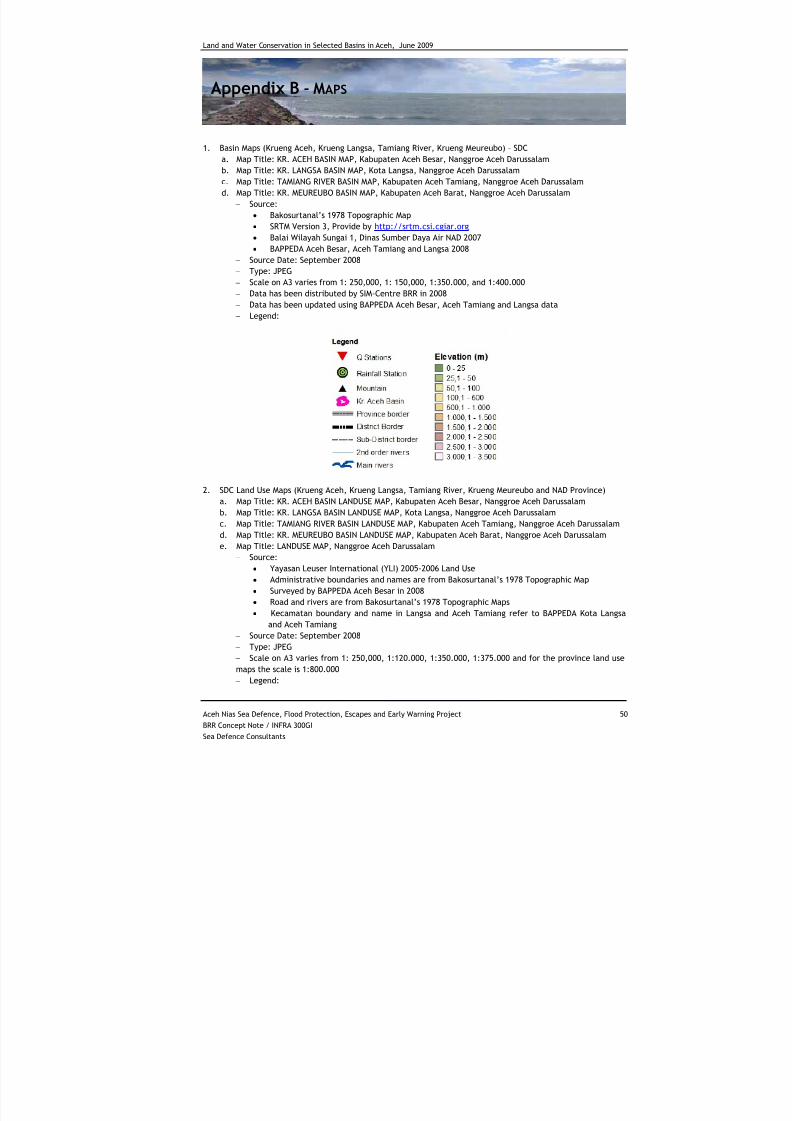
7/27/2019 Konservasi Air Dan Tanah Di Wilayah Sungai Terpilih Di Aceh
http://slidepdf.com/reader/full/konservasi-air-dan-tanah-di-wilayah-sungai-terpilih-di-aceh 60/70
Land and Water Conservation in Selected Basins in Aceh, June 2009
Aceh Nias Sea Defence, Flood Protection, Escapes and Early Warning Project 50
BRR Concept Note / INFRA 300GI
Sea Defence Consultants
Appendix B - MAPS
1. Basin Maps (Krueng Aceh, Krueng Langsa, Tamiang River, Krueng Meureubo) – SDC
a. Map Title: KR. ACEH BASIN MAP, Kabupaten Aceh Besar, Nanggroe Aceh Darussalam
b. Map Title: KR. LANGSA BASIN MAP, Kota Langsa, Nanggroe Aceh Darussalam
c. Map Title: TAMIANG RIVER BASIN MAP, Kabupaten Aceh Tamiang, Nanggroe Aceh Darussalam
d. Map Title: KR. MEUREUBO BASIN MAP, Kabupaten Aceh Barat, Nanggroe Aceh Darussalam
− Source:
• Bakosurtanal’s 1978 Topographic Map
• SRTM Version 3, Provide by http://srtm.csi.cgiar.org
• Balai Wilayah Sungai 1, Dinas Sumber Daya Air NAD 2007
• BAPPEDA Aceh Besar, Aceh Tamiang and Langsa 2008
− Source Date: September 2008
− Type: JPEG
− Scale on A3 varies from 1: 250,000, 1: 150,000, 1:350.000, and 1:400.000
− Data has been distributed by SIM-Centre BRR in 2008
− Data has been updated using BAPPEDA Aceh Besar, Aceh Tamiang and Langsa data
− Legend:
2. SDC Land Use Maps (Krueng Aceh, Krueng Langsa, Tamiang River, Krueng Meureubo and NAD Province)
a. Map Title: KR. ACEH BASIN LANDUSE MAP, Kabupaten Aceh Besar, Nanggroe Aceh Darussalam
b. Map Title: KR. LANGSA BASIN LANDUSE MAP, Kota Langsa, Nanggroe Aceh Darussalam
c. Map Title: TAMIANG RIVER BASIN LANDUSE MAP, Kabupaten Aceh Tamiang, Nanggroe Aceh Darussalam
d. Map Title: KR. MEUREUBO BASIN LANDUSE MAP, Kabupaten Aceh Barat, Nanggroe Aceh Darussalam
e. Map Title: LANDUSE MAP, Nanggroe Aceh Darussalam
− Source:• Yayasan Leuser International (YLI) 2005-2006 Land Use
• Administrative boundaries and names are from Bakosurtanal’s 1978 Topographic Map
• Surveyed by BAPPEDA Aceh Besar in 2008
• Road and rivers are from Bakosurtanal’s 1978 Topographic Maps
• Kecamatan boundary and name in Langsa and Aceh Tamiang refer to BAPPEDA Kota Langsa
and Aceh Tamiang
− Source Date: September 2008
− Type: JPEG
− Scale on A3 varies from 1: 250,000, 1:120.000, 1:350.000, 1:375.000 and for the province land use
maps the scale is 1:800.000
− Legend:
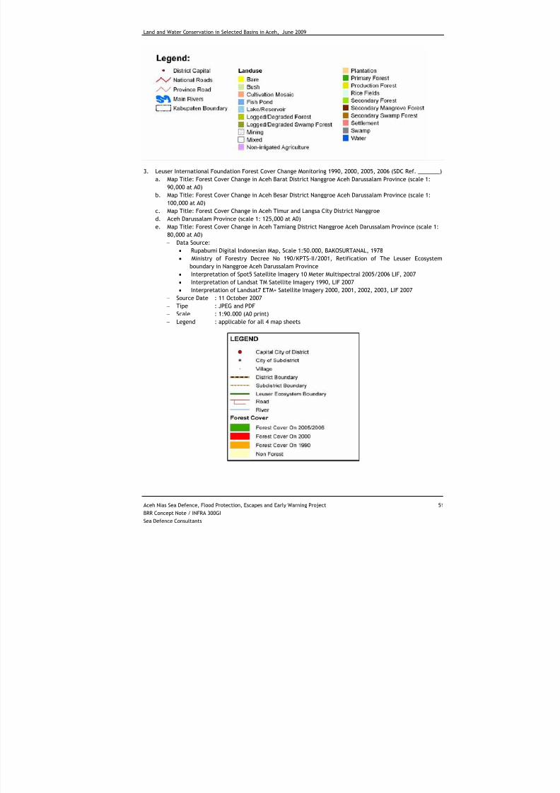
7/27/2019 Konservasi Air Dan Tanah Di Wilayah Sungai Terpilih Di Aceh
http://slidepdf.com/reader/full/konservasi-air-dan-tanah-di-wilayah-sungai-terpilih-di-aceh 61/70
Land and Water Conservation in Selected Basins in Aceh, June 2009
Aceh Nias Sea Defence, Flood Protection, Escapes and Early Warning Project 51
BRR Concept Note / INFRA 300GI
Sea Defence Consultants
3. Leuser International Foundation Forest Cover Change Monitoring 1990, 2000, 2005, 2006 (SDC Ref. _______)
a. Map Title: Forest Cover Change in Aceh Barat District Nanggroe Aceh Darussalam Province (scale 1:
90,000 at A0)
b. Map Title: Forest Cover Change in Aceh Besar District Nanggroe Aceh Darussalam Province (scale 1:100,000 at A0)
c. Map Title: Forest Cover Change in Aceh Timur and Langsa City District Nanggroe
d. Aceh Darussalam Province (scale 1: 125,000 at A0)
e. Map Title: Forest Cover Change in Aceh Tamiang District Nanggroe Aceh Darussalam Province (scale 1:
80,000 at A0)
− Data Source:
• Rupabumi Digital Indonesian Map, Scale 1:50.000, BAKOSURTANAL, 1978
• Ministry of Forestry Decree No 190/KPTS-II/2001, Retification of The Leuser Ecosystem
boundary in Nanggroe Aceh Darussalam Province
• Interpretation of Spot5 Satellite Imagery 10 Meter Multispectral 2005/2006 LIF, 2007
• Interpretation of Landsat TM Satellite Imagery 1990, LIF 2007
• Interpretation of Landsat7 ETM+ Satellite Imagery 2000, 2001, 2002, 2003, LIF 2007
− Source Date : 11 October 2007
− Tipe : JPEG and PDF
− Scale : 1:90.000 (A0 print)
− Legend : applicable for all 4 map sheets
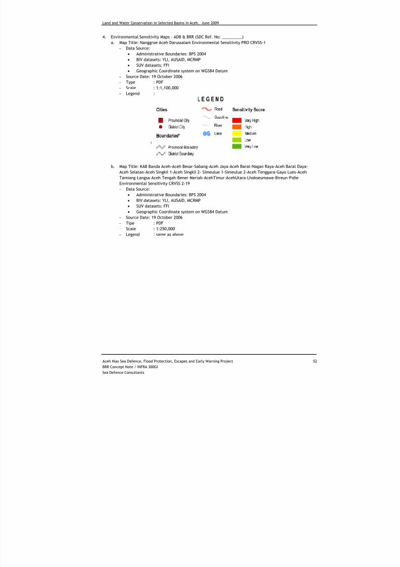
7/27/2019 Konservasi Air Dan Tanah Di Wilayah Sungai Terpilih Di Aceh
http://slidepdf.com/reader/full/konservasi-air-dan-tanah-di-wilayah-sungai-terpilih-di-aceh 62/70
Land and Water Conservation in Selected Basins in Aceh, June 2009
Aceh Nias Sea Defence, Flood Protection, Escapes and Early Warning Project 52
BRR Concept Note / INFRA 300GI
Sea Defence Consultants
4. Environmental Sensitivity Maps – ADB & BRR (SDC Ref. No: _________)
a. Map Title: Nanggroe Aceh Darussalam Environmental Sensitivity PRO CRVSS-1
− Data Source:
• Administrative Boundaries: BPS 2004
• BIV datasets: YLI, AUSAID, MCRMP
• SUV datasets: FFI
• Geographic Coordinate system on WGS84 Datum− Source Date: 19 October 2006
− Type : PDF
− Scale : 1:1,100,000
− Legend :
b. Map Title: KAB Banda Aceh-Aceh Besar-Sabang-Aceh Jaya-Aceh Barat-Nagan Raya-Aceh Barat Daya-
Aceh Selatan-Aceh Singkil 1-Aceh Singkil 2- Simeulue 1-Simeulue 2-Aceh Tenggara-Gayo Lues-Aceh
Tamiang-Langsa-Aceh Tengah-Bener Meriah-AcehTimur-AcehUtara-Lhokseumawe-Bireun-Pidie
Environmental Sensitivity CRVSS 2-19
− Data Source:
• Administrative Boundaries: BPS 2004
• BIV datasets: YLI, AUSAID, MCRMP
• SUV datasets: FFI
• Geographic Coordinate system on WGS84 Datum− Source Date: 19 October 2006
− Tipe : PDF
− Scale : 1:250,000
− Legend : same as above
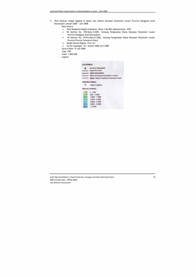
7/27/2019 Konservasi Air Dan Tanah Di Wilayah Sungai Terpilih Di Aceh
http://slidepdf.com/reader/full/konservasi-air-dan-tanah-di-wilayah-sungai-terpilih-di-aceh 63/70
Land and Water Conservation in Selected Basins in Aceh, June 2009
Aceh Nias Sea Defence, Flood Protection, Escapes and Early Warning Project 53
BRR Concept Note / INFRA 300GI
Sea Defence Consultants
5. Peta Sebaran illegal logging di dalam dan sekitar Kawasan Ekosistem Leuser Provinsi Nanggroe Aceh
Darussalam Januari 2006 – Juni 2008
− Data Source:
• Peta Rupabumi Digital Indonesia, Skala 1:50.000, Bakosurtanal, 1978
• SK Menhut No. 190/Kpts-II/2001, tentang Pengesahan Batas Kawasan Ekosistem Leuser
Provinsi Nanggroe Aceh Darussalam• SK Menhut No. 10193/Kpts-II/2002, tentang Pengesahan Batas Kawasan Ekosistem Leuser
Provinsi Provinsi Sumatera Utara
• Model Elevasi Digital, 25 m YLI
• Survei Lapangan, YLI, Januari 2006-Juni 2008
− Source Date: 15 Juli 2008
− Type: PDF
− Scale: 1:850.000
− Legend
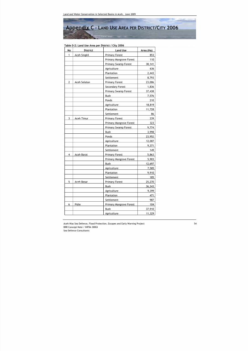
7/27/2019 Konservasi Air Dan Tanah Di Wilayah Sungai Terpilih Di Aceh
http://slidepdf.com/reader/full/konservasi-air-dan-tanah-di-wilayah-sungai-terpilih-di-aceh 64/70
Land and Water Conservation in Selected Basins in Aceh, June 2009
Aceh Nias Sea Defence, Flood Protection, Escapes and Early Warning Project 54
BRR Concept Note / INFRA 300GI
Sea Defence Consultants
Appendix C - LAND USE AREA PER DISTRICT/CITY 2006
Table 0-2: Land Use Area per District / City 2006
No District Land Use Area (Ha)
1 Aceh Singkil Primary Forest 853
Primary Mangrove Forest 110
Primary Swamp Forest 38,141
Agriculture 636
Plantation 2,443
Settlement 8,793
2 Aceh Selatan Primary Forest 23,006
Secondary Forest 1,836Primary Swamp Forest 37,438
Bush 7,576
Ponds 210
Agriculture 18,819
Plantation 11,728
Settlement 86
3 Aceh Timur Primary Forest 239
Primary Mangrove Forest 323
Primary Swamp Forest 9,774
Bush 3,998
Ponds 23,952
Agriculture 12,007
Plantation 9,371
Settlement 149
4 Aceh Barat Primary Forest 5,863
Primary Mangrove Forest 5,903
Bush 12,697
Agriculture 7,585
Plantation 9,910Settlement 185
5 Aceh Besar Primary Forest 25,270
Bush 36,343
Agriculture 9,399
Plantation 471
Settlement 987
6 Pidie Primary Mangrove Forest 104
Bush 37,910
Agriculture 11,329
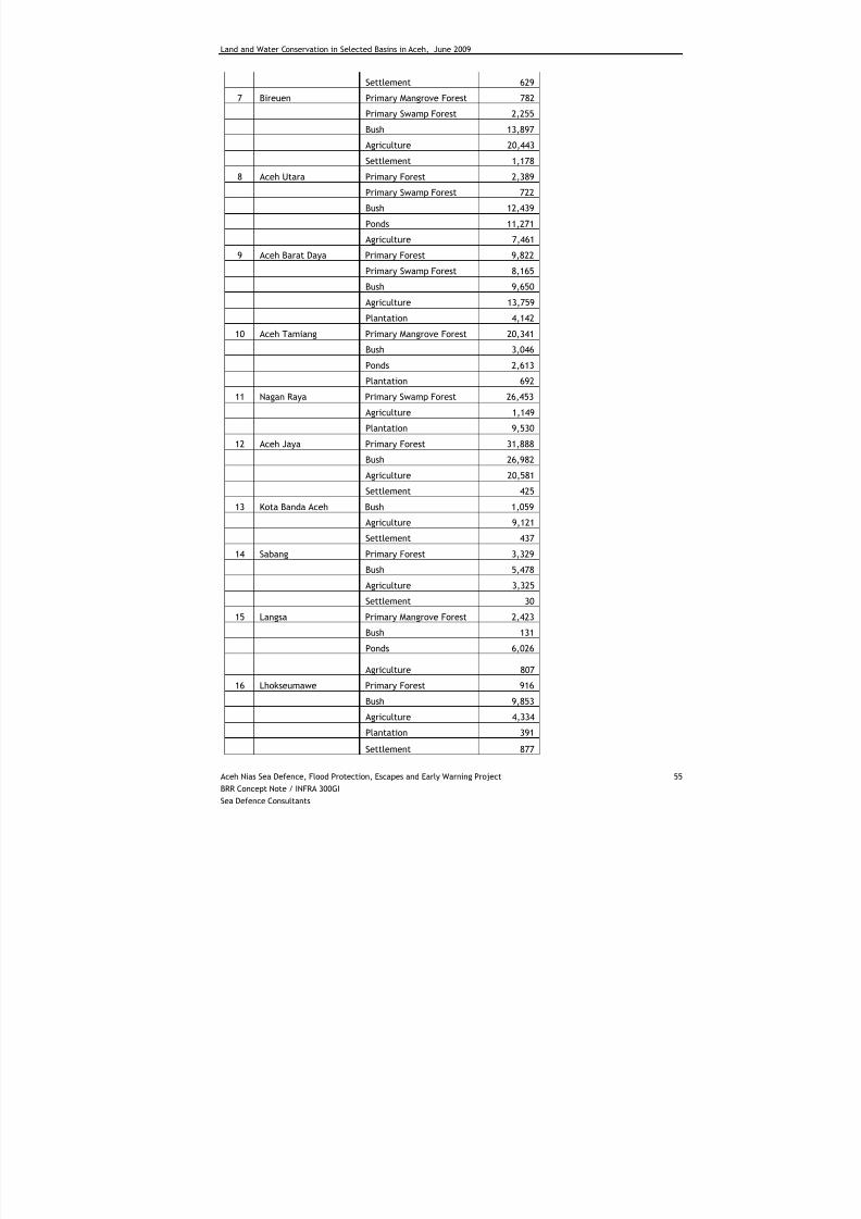
7/27/2019 Konservasi Air Dan Tanah Di Wilayah Sungai Terpilih Di Aceh
http://slidepdf.com/reader/full/konservasi-air-dan-tanah-di-wilayah-sungai-terpilih-di-aceh 65/70
Land and Water Conservation in Selected Basins in Aceh, June 2009
Aceh Nias Sea Defence, Flood Protection, Escapes and Early Warning Project 55
BRR Concept Note / INFRA 300GI
Sea Defence Consultants
Settlement 629
7 Bireuen Primary Mangrove Forest 782
Primary Swamp Forest 2,255
Bush 13,897
Agriculture 20,443
Settlement 1,178
8 Aceh Utara Primary Forest 2,389
Primary Swamp Forest 722
Bush 12,439
Ponds 11,271
Agriculture 7,461
9 Aceh Barat Daya Primary Forest 9,822
Primary Swamp Forest 8,165
Bush 9,650
Agriculture 13,759
Plantation 4,142
10 Aceh Tamiang Primary Mangrove Forest 20,341
Bush 3,046
Ponds 2,613
Plantation 692
11 Nagan Raya Primary Swamp Forest 26,453
Agriculture 1,149
Plantation 9,530
12 Aceh Jaya Primary Forest 31,888
Bush 26,982
Agriculture 20,581
Settlement 425
13 Kota Banda Aceh Bush 1,059
Agriculture 9,121
Settlement 437
14 Sabang Primary Forest 3,329
Bush 5,478
Agriculture 3,325
Settlement 3015 Langsa Primary Mangrove Forest 2,423
Bush 131
Ponds 6,026
Agriculture 807
16 Lhokseumawe Primary Forest 916
Bush 9,853
Agriculture 4,334
Plantation 391
Settlement 877
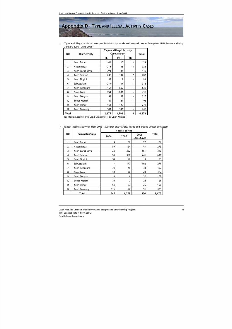
7/27/2019 Konservasi Air Dan Tanah Di Wilayah Sungai Terpilih Di Aceh
http://slidepdf.com/reader/full/konservasi-air-dan-tanah-di-wilayah-sungai-terpilih-di-aceh 66/70
Land and Water Conservation in Selected Basins in Aceh, June 2009
Aceh Nias Sea Defence, Flood Protection, Escapes and Early Warning Project 56
BRR Concept Note / INFRA 300GI
Sea Defence Consultants
Appendix D - TYPE AND ILLEGAL ACTIVITY CASES
1. Type and illegal activity cases per District/city inside and around Leuser Ecosystem NAD Province during
January 2006 – June 2008
Type and Illegal Activity
Case AmountNO District/City
IL PR TB
Total
1 Aceh Barat 106 15 - 121
2 Nagan Raya 275 46 1 322
3 Aceh Barat Daya 393 47 - 440
4 Aceh Selatan 636 149 2 787
5 Aceh Singkil 83 13 - 96
6 Subussalam 279 37 - 316
7 Aceh Tenggara 167 659 - 826
8 Gayo Lues 154 282 - 436
9 Aceh Tengah 52 158 - 210
10 Bener Meriah 69 127 - 196
11 Aceh Timur 158 120 - 278
12 Aceh Tamiang 303 343 - 646
Total 2,675 1,996 3 4,674
IL: Illegal Logging, PR: Land Grabbing, TB: Open Mining
2. Illegal logging activities from 2006 – 2008 per district/city inside and around Leuser Ecosystem
Years / period
NO Kabupaten/kota2006 2007
2008
(Jan-June)
Total
1 Aceh Barat 19 60 27 106
2 Nagan Raya 59 164 52 275
3 Aceh Barat Daya 20 222 151 393
4 Aceh Selatan 59 336 241 636
5 Aceh Singkil 51 19 13 83
6 Subussalam - 177 102 279
7 Aceh Tenggara 79 45 43 167
8 Gayo Lues 33 72 49 154
9 Aceh Tengah 14 6 32 52
10 Bener Meriah 39 7 23 69
11 Aceh Timur 59 73 26 158
12 Aceh Tamiang 115 97 91 303
Total 547 1,278 850 2,675
7/27/2019 Konservasi Air Dan Tanah Di Wilayah Sungai Terpilih Di Aceh
http://slidepdf.com/reader/full/konservasi-air-dan-tanah-di-wilayah-sungai-terpilih-di-aceh 67/70
Land and Water Conservation in Selected Basins in Aceh, June 2009
Aceh Nias Sea Defence, Flood Protection, Escapes and Early Warning Project 57
BRR Concept Note / INFRA 300GI
Sea Defence Consultants
3. Encroachment (Land grabbing) activities from 2006 – 2008 per district/city inside and around Leuser
Ecosystem
Years / Period
NO Kabupaten/Kota
2006 2007
2008
(Jan-June)
Total
1 Aceh Barat 3 9 3 152 Nagan Raya 12 20 14 46
3 Aceh Barat Daya 2 18 27 47
4 Aceh Selatan 16 61 72 149
5 Aceh Singkil 9 3 1 13
6 Subussalam - 24 13 37
7 Aceh Tenggara 162 302 195 659
8 Gayo Lues 45 130 107 282
9 Aceh Tengah 19 45 94 158
10 Bener Meriah 14 37 76 127
11 Aceh Timur 3 60 57 120
12 Aceh Tamiang 78 160 105 343
Total 363 869 764 1,996
7/27/2019 Konservasi Air Dan Tanah Di Wilayah Sungai Terpilih Di Aceh
http://slidepdf.com/reader/full/konservasi-air-dan-tanah-di-wilayah-sungai-terpilih-di-aceh 68/70
Land and Water Conservation in Selected Basins in Aceh, June 2009
Aceh Nias Sea Defence, Flood Protection, Escapes and Early Warning Project 58
BRR Concept Note / INFRA 300GI
Sea Defence Consultants
Appendix E - FOREST COVER CHANGE IN LEUSER ECOSYSTEM
Table 0-3: Forest Cover Change 1990-2000-2006 in Leuser Ecosystem
Forest
Loss
Degradation
Rate
Forest
Loss
Degradation
RateKabupaten 1990 2000 2006
1990 -
2000
1990 -
2000
2000 -
2006
2000 -
2006
Ha Ha Ha/Year Ha Ha/Year
Aceh barat 7,365 6,609 6,371 756 76 237 40
Aceh barat daya 157,218 134,259 115,743 22,959 2,296 18,516 3,086
Aceh selatan 350,214 320,077 315,204 30,137 3,014 4,873 812
Aceh singkil 22,148 21,684 21,623 464 46 61 10
Aceh tamiang 73,236 57,538 57,131 15,698 1,570 406 68Aceh tengah 102,272 95,864 95,116 6,408 641 748 125
Aceh tenggara 367,568 352,554 351,336 15,014 1,501 1,217 203
Aceh timur 289,709 264,785 263,672 24,924 2,492 1,113 186
Aceh utara 30,446 27,393 26,891 3,052 305 502 84
Bener meriah 105,832 94,952 94,267 10,881 1,088 685 114
Gayo lues 436,238 422,667 421,009 13,571 1,357 1,658 276
Nagan raya 181,010 142,943 135,961 38,068 3,807 6,982 1,164
Subulussalam 35,426 29,339 28,692 6,087 609 648 108
Total 2,158,682 19,706,63 1,933,017 188,019 18,802 37,646 6,274
Source: Yayasan Leuser Indonesia
7/27/2019 Konservasi Air Dan Tanah Di Wilayah Sungai Terpilih Di Aceh
http://slidepdf.com/reader/full/konservasi-air-dan-tanah-di-wilayah-sungai-terpilih-di-aceh 69/70
Land and Water Conservation in Selected Basins in Aceh, June 2009
Aceh Nias Sea Defence, Flood Protection, Escapes and Early Warning Project 59
BRR Concept Note / INFRA 300GI
Sea Defence Consultants
Appendix F - PLANTED AREA AND PRODUCTION IN NAD
1. Palm Oil Planted Area and Production of Small Holder per Water Basin in Nanggroe Aceh Darussalam
Province, 2006
2006
District/City
Area (ha)
Production
(ton)
Aceh Besar 1,140 0
Aceh Tamiang 15,876 108,310
Langsa 133 689
Aceh Barat 3,892 13,518
Source: Estate Service of Nanggroe Aceh Darussalam Province
2. Palm Oil Planted Area and Production of Estate Enterprise per Water Basin in Nanggroe Aceh DarussalamProvince, 2006
2006
District/City
Area (ha)
Production
(ton)
Aceh Besar 0 0
Aceh Tamiang 30138 58756
Langsa 0
Aceh Barat 11,292 1,850
Source: Estate Service of Nanggroe Aceh Darussalam Province
3. Rubber Planted Area and Production of Small Holder per Water Basin in Nanggroe Aceh Darussalam
Province, 2006
2006
District/City
Area (ha)
Production
(ton)
Aceh Besar 10 0
Aceh Tamiang 16,311 10,919
Langsa 864 521
Aceh Barat 16,207 11,649
Source: Estate Service of Nanggroe Aceh Darussalam Province
4. Rubber Planted Area and Production of Estate Enterprise per Water Basin in Nanggroe Aceh Darussalam
Province, 2006
2006
District/City
Area (ha)
Production
(ton)
Aceh Besar 0 0
Aceh Tamiang 3,375 1,402
Langsa 0 0
Aceh Barat 4,968 1,367
Source: Estate Service of Nanggroe Aceh Darussalam Province
7/27/2019 Konservasi Air Dan Tanah Di Wilayah Sungai Terpilih Di Aceh
http://slidepdf.com/reader/full/konservasi-air-dan-tanah-di-wilayah-sungai-terpilih-di-aceh 70/70
Land and Water Conservation in Selected Basins in Aceh, June 2009
5. Cacao Planted Area and Production of Small Holder per Water Basin in Nanggroe Aceh Darussalam Province,
2006
2006
District/City
Area (ha)
Production
(ton)
Aceh Besar 684 182
Aceh Tamiang 976 358
Langsa 225 150
Aceh Barat 367 45
Source: Estate Service of Nanggroe Aceh Darussalam Province
6. Cacao Planted Area and Production of Estate Enterprise per Water Basin in Nanggroe Aceh Darussalam
Province, 2006
2006
District/City
Area (ha)
Production
(ton)
Aceh Besar 0 0
Aceh Tamiang 65 0Langsa 0 0
Aceh Barat 0 0
Source: Estate Service of Nanggroe Aceh Darussalam Province
7. Coffee Planted Area and Production of Small Holder per Water Basin in Nanggroe Aceh Darussalam
Province, 2006
2006
District/City
Area (ha)
Production
(ton)
Aceh Besar 1466 765
Aceh Tamiang 105 14
Langsa 0 0Aceh Barat 533 176
Source: Estate Service of Nanggroe Aceh Darussalam Province
8. Coffee Planted Area and Production of Estate Enterprise per Water Basin in Nanggroe Aceh Darussalam
Province, 2006
2006
District/City
Area (ha)
Production
(ton)
Aceh Besar 1466 765
Aceh Tamiang 105 14
Langsa 0 0
Aceh Barat 533 176
Source: Estate Service of Nanggroe Aceh Darussalam Province