contents...5. umaryono, ilmu ukur tanah seri a 6. umaryono, ilmu ukur tanah seri b 7. ghilani dg and...
TRANSCRIPT
i
Contents 1. GD2101 Positioning I...................................................................................................................................... 1
2. GD2102 Geometric Geodesy ......................................................................................................................... 3
3. GD2103 Statistics Geodesy ............................................................................................................................ 5
4. GD2104 Geodetic Computation I ................................................................................................................. 7
5. GD2105 Introduction to Spatial System..................................................................................................... 9
6. GD2106 Geospatial Expedition (Field Work)......................................................................................... 12
7. GD2201 Positioning II .................................................................................................................................. 15
8. GD2202 Geometric Reference System ...................................................................................................... 18
9. GD2203 Estimation and Approximation .................................................................................................. 20
10. GD2204 Geodetic Computation II......................................................................................................... 22
11. GD2205 Satellite Geodesy ....................................................................................................................... 25
12. GD2206 Geospatial Law and Regulations ........................................................................................... 27
13. GD3101 Terrestrial Mapping ................................................................................................................. 29
14. GD3102 Hydrography I ........................................................................................................................... 32
15. GD3103 Photogrammetry I .................................................................................................................... 35
16. GD3104 Spatial Database ........................................................................................................................ 37
17. GD3105 Surveying by GNSS .................................................................................................................. 39
18. GD3201 Cartography................................................................................................................................ 41
19. GD3202 Hydrography II ......................................................................................................................... 43
20. GD3203 Photogrammetry II .................................................................................................................. 46
21. GD3204 Thematic Mapping ................................................................................................................... 48
22. GD3205 Remote Sensing ......................................................................................................................... 50
23. GD3206 Field Camp .................................................................................................................................. 52
24. GD4101 Geographic Information System ........................................................................................... 55
25. GD4102 Cadastre System ........................................................................................................................ 57
26. GD4103 Environmental Geography ..................................................................................................... 60
27. GD4001 Internship .................................................................................................................................... 62
28. GD4002 Undergraduate Thesis ............................................................................................................. 64
ii
29. GD4201 Geospatial Information Industry .......................................................................................... 67
30. GD4202 Quality Management System ................................................................................................. 70
31. GD3106 Introduction to Physical Geodesy......................................................................................... 73
32. GD4104 Environmental Remote Sensing ............................................................................................ 75
33. GD4105 Hydroinformatics ...................................................................................................................... 77
34. GD4106 Construction Surveying........................................................................................................... 81
35. GD4107 Selected Topics .......................................................................................................................... 83
36. GD4203 Quantity Surveying .................................................................................................................. 85
37. GD4204 Deformation ................................................................................................................................ 88
38. GD4205 Maritime Boundaries ................................................................................................................ 91
39. GD4206 Engineering of Geographic Information System .............................................................. 93
40. GD4207 Marine Geodesy ........................................................................................................................ 95

iii
1. S
1
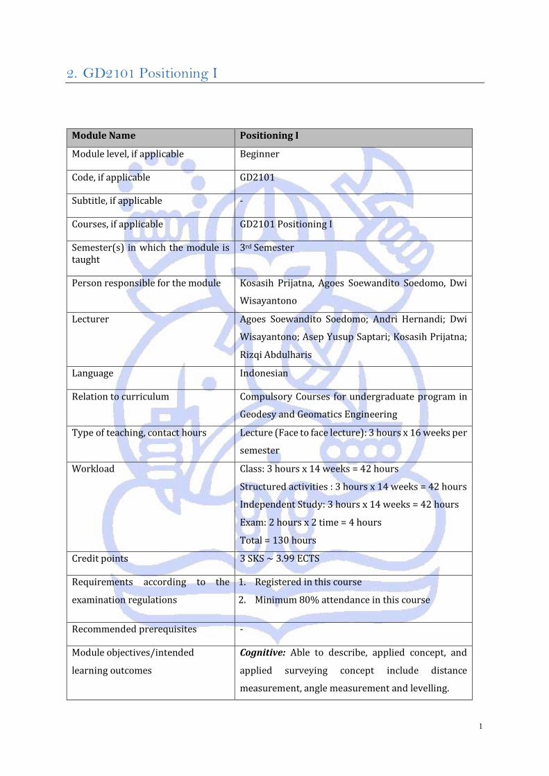
2. GD2101 Positioning I
Module Name Positioning I
Module level, if applicable Beginner
Code, if applicable GD2101
Subtitle, if applicable -
Courses, if applicable GD2101 Positioning I
Semester(s) in which the module is taught
3rd Semester
Person responsible for the module Kosasih Prijatna, Agoes Soewandito Soedomo, Dwi
Wisayantono
Lecturer
Agoes Soewandito Soedomo; Andri Hernandi; Dwi
Wisayantono; Asep Yusup Saptari; Kosasih Prijatna;
Rizqi Abdulharis
Language Indonesian
Relation to curriculum Compulsory Courses for undergraduate program in
Geodesy and Geomatics Engineering
Type of teaching, contact hours Lecture (Face to face lecture): 3 hours x 16 weeks per
semester
Workload
Class: 3 hours x 14 weeks = 42 hours
Structured activities : 3 hours x 14 weeks = 42 hours
Independent Study: 3 hours x 14 weeks = 42 hours
Exam: 2 hours x 2 time = 4 hours
Total = 130 hours
Credit points 3 SKS ~ 3.99 ECTS
Requirements according to the
examination regulations
1. Registered in this course
2. Minimum 80% attendance in this course
Recommended prerequisites -
Module objectives/intended
learning outcomes
Cognitive: Able to describe, applied concept, and
applied surveying concept include distance
measurement, angle measurement and levelling.
2
Psychomotor: Students are able to perform
positioning, determining the position, angle, distance
and levelling
Affective: Following the rules of the courses
Content
This course deals with concept and determination
methods of direction, angle, distance and position.
Concept of 2D dan 3D position, application concept
and determination methods of direction, angle,
distance, and positioning (horizontal and vertical).
Study and examination
requirements and forms of
examination
Cognitive: Midterm exam, Final exam, Quizzes,
Assignments
Psychomotor: Practice
Affective: Assessed from the element /variables
achievement, namely (a) Contributions (attendance,
active, role, initiative, language), (b) Being on time,
(c) Effort.
Media employed Classical teaching tools with white board and power
point presentation
Reading list
1. Cormack, 1997, Surveying
2. Deumlich, 1997, Surveying Instrument
3. Abidin Z A, 2002, Survey dengan GPS, Penerbit
Pradnya Paramita
4. Wilson, 1971, Land Surveying
5. Umaryono, Ilmu Ukur Tanah Seri A
6. Umaryono, Ilmu Ukur Tanah Seri B
7. Ghilani DG and Wolf PR, Elementary Surveying:
An Introduction to Geomatics (latest edition)
3
3. GD2102 Geometric Geodesy
Module Name Geometric Geodesy
Module level, if applicable Beginner
Code, if applicable GD2102
Subtitle, if applicable -
Courses, if applicable GD2102 Geometric Geodesy
Semester(s) in which the module is taught
3rd Semester
Person responsible for the module Dina Anggreni Sarsito, Kosasih Prijatna, Wedyanto
Lecturer
Dina Anggreni Sarsito; Vera Sadarviana; Kosasih
Prijatna; Teguh Purnama Sidiq; Wedyanto; Heri
Andreas
Language Indonesian
Relation to curriculum Compulsory Courses for undergraduate program in
Geodesy and Geomatics engineering
Type of teaching, contact hours
Lecture (Face to face lecture): 4 hours x 16 weeks per
semester
Tutorial
Workload
Class: 4 hours x 14 weeks = 56 hours
Structured activities : 4 hours x 14 weeks = 56 hours
Independent Study: 4 hours x 14 weeks = 56 hours
Exam: 2 hours x 2 time = 4 hours
Total = 172 hours
Credit points 4 sks ~ 5.32 ECTS
Requirements according to the
examination regulations
1. Registered in this course
2. Minimum 80% attendance in this course
Recommended prerequisites -
Module objectives/intended Cognitive: Able to understand and applied geometric
geodesy concept.
4
learning outcomes
Psychomotor: Students are able to perform
Geometric Geodesy Calculation
Affective: Following the rules of the courses
Content
This course provides the students basic knowledge
on geometry of ellipsoid, geodetic datum, geodetic
positioning computation and map projection. In
addition, this course emphasizes the use of computer
programming (i.e. MATLAB) to accelerate the
student’s understanding
Introduction to geometric geodesy, geometry of
ellipsoid, geodetic datum, direction, angle/azimuth,
distance above ellipsoid surface, geodetic
computation and map projection.
Study and examination
requirements and forms of
examination
Cognitif: Written test (Mid Test, Final Test,
Assignment, Quiz
Psychomotor: Practice
Affective: Assessed from the element /variables
achievement, namely :(a) Contributions (attendance,
active, role, initiative, language) , (b) Being on time ,
(c) Effort
Media employed Classical teaching tools with white board and power
point presentation
Reading list
1. Borre K: Ellipsoidal Geometry and Conformal
Mapping, Lecture Notes, Aalborg University,
2003
2. Jekely C: Geometric Reference Systems in
Geodesy, Division of Geodesy and Geospatial
Science, School of Earth Sciences, Ohio State
University,2006
3. Krakiwsky EJ: Conformal Map Projection in
Geodesy, Lecture Notes 37, University of New
Brunswick, 1973.
4. Krakiwsky EJ & Thompson DB: Geodetic Position
Computations, Lecture Notes 39, University of
New Brunswick, 1978.
5
4. GD2103 Statistics Geodesy
Module Name Statistics in Geodesy and Geomatics Engineering
Module level, if applicable Beginner
Code, if applicable GD2103
Subtitle, if applicable -
Courses, if applicable GD2103 Statistics Geodesy
Semester(s) in which the module is taught
3rd Semester
Person responsible for the module Agustinus Bambang SETYADJI, Dudy Darmawan
Wijaya, Irwan Meilano
Lecturer
Agustinus Bambang SETYADJI; Zamzam Akhmad
Jamaluddin T.; Dudy Darmawan Wijaya; Irwan
Gumilar; Irwan Meilano; Vera Sadarviana
Language Indonesian
Relation to curriculum Compulsory Courses for undergraduate program in
Geodesy and Geomatics Engineering
Type of teaching, contact hours Class Lecture: 4 hours x 16 weeks per semester
Computation Tutorial.
Workload
Class: 4 hours x 14 weeks = 56 hours
Structured activities : 4 hours x 14 weeks = 56 hours
Independent Study: 4 hours x 14 weeks = 56 hours
Exam: 2 hours x 2 time = 4 hours
Total = 172 hours
Credit points 4 sks ~ 5.32 ECTS
Requirements according to the
examination regulations
1. Registered in this course
2. Minimum 80% attendance in this course
Recommended prerequisites -
Module objectives/intended
learning outcomes
Cognitive: Able to understand and analize basic
statistics in geodesy and geomatics applications
6
Psychomotoric: Students are able to apply basic
statistic for geodesy and geomatics applications
Affective: Following the rules of the courses
Content
Review/recall of basic concept of Statistics,
Introductory statistic (idealization, simplification),
Introduction to Geodesy and Geomatics data
characteristic, descriptive and inferential statistic,
probability concept and data distribution, estimation
(mean, median, modus, range, standard deviation,
variance, outlier), statistical test (Null Hypothesis,
rejection criteria), statistical application to Geodesy
& Geomatics Problems for estimation and quality
control.
Study and examination
requirements and forms of
examination
Cognitive: Written test (Mid Test, Final Test,
Assignment, Quiz)
Psychomotoric: Tutorial Practice
Affective: Assessed from the element /variables
achievement, namely: (a) Contributions (attendance,
active, role, initiative, language) , (b) Being on time ,
(c) Effort
Media employed Classical teaching tools with white board and visual
presentation material
Reading list 1. Probability & statistics for engineers &
scientists/Ronald E. Walpole [et al.] 9th ed.,
2012, Prentice Hall.
2. Adjustment computations: spatial data analysis
/ Charles D. Ghilani. 5th ed. 2010, John Wiley &
Sons, Inc.
7
5. GD2104 Geodetic Computation I
Module Name Geodetic Computation I
Module level, if applicable Beginner
Code, if applicable GD 2104
Subtitle, if applicable -
Courses, if applicable GD 2104 Geodetic Computation I
Semester(s) in which the module is
taught
3rd Semester
Person responsible for the module Dudy Darmawan Wijaya , Dina Anggreni Sarsito,
Wedyanto
Lecturer
Dudy Darmawan Wijaya; Heri Andreas; Irwan
Meilano; Irwan Gumilar; Wedyanto; Dina Anggreni
Sarsito;
Language Indonesian
Relation to curriculum Compulsory Courses for undergraduate program in
Geodesy and Geomatics engineering
Type of teaching, contact hours
Type of teaching: Face to face lecture, literature
review, exercise/tutorial
Contact hour: 12 hours x 14 weeks per semester
Workload
Class: 3 hours x 14 weeks = 42 hours
Structured activities : 3 hours x 14 weeks = 42 hours
Independent Study: 3 hours x 14 weeks = 42 hours
Exam: 2 hours x 2 time = 4 hours
Total = 130 hours
Credit points 3 SKS ~ 3.99 ECTS
Requirements according to the
examination regulations
1. Registered in this course
2. Minimum 80% attendance in this course
Recommended prerequisites -
8
Module objectives/intended
learning outcomes
Cognitive: Students are able to apply principles of
elementary linear algebra to solve linearized
problems in geodesy and geomatics
Psychomotor: Students are able to develop a system
of linear equations, which relates the observations
and parameters, and solve it using an elementary
linear algebra
Affective: Students are able to obey the rules of the
courses
Content
This course provides an elementary linear algebra
(i.e. a system of linear equations, Gaussian
elimination, determinant, eigenvector/eigenvalue)
and a concept of linearization as well as their
applications to solve problems in geodetic
positioning and coordinate transformations.
Study and examination
requirements and forms of
examination
Cognitive: Assessed from midterm test, end of term
test, assignments, and quiz
Psychomotor: Assessed from practice
Affective: Assessed from variables of performance,
namely: (a) Contribution (attendance, being active,
role, initiative, language), (b) Appreciating time, (c)
Effort
Media employed Classical teaching tools with white board and power
point presentation
Reading list 1. H. Anton and C. Rorres (2014) Elementary linear
algebra, 11th eds., John Willey and Sons, Inc.
ISBN: 978-1-118-43441-3.
2. S.C. Chapra andR.P. Canale, (1998) Numerical
Methods for Engineers, McGraw-Hill Book Co.
3. G. Strang and K. Borre (1997) Linear Algebra,
Geodesy & GPS, Cambridge-Wellesley.
9
6. GD2105 Introduction to Spatial System
Module Name Introduction to Spatial System
Module level, if applicable Beginner
Code, if applicable GD2105
Subtitle, if applicable -
Courses, if applicable GD2105 Introduction to Spatial System
Semester(s) in which the module is
taught
3rd Semester
Person responsible for the module Prof. Widyo Nugroho S, Poerbandono, Akhmad Riqqi
Lecturer Widyo Nugroho; Eka Djunarsjah; Akhmad Riqqi; Dwi
Wisayantono; Poerbandono
Language Indonesian
Relation to curriculum Compulsory Courses for undergraduate program in
Geodesy and Geomatics Engineering
Type of teaching, contact hours
Lecture (Face to face lecture): 2 hours x 16 weeks per
semester
Tutorial
Workload
Lecture (class): 2 hours x 14 weeks = 28 hours
Structured activities : 2 hours x 14 weeks = 28 hours
Independent Study: 2 hours x 14 weeks = 28 hours
Exam: 2 hours x 2 time = 4 hours
Total = 86 hours
Credit points 2 SKS ~ 2.66 ECTS
Requirements according to the
examination regulations
-
Recommended prerequisites -
Module objectives/intended
learning outcomes
1. Students can explain how to understand a
phenomenon through a systems approach
10
2. Students can explain that a complex system
can be simplified in the model
3. Students can demonstrate that the idea of a
system is an original scholarly perspective
that is not a procedure or rule that has been
there or seen
4. Students are able to explain the definition of
space and issues in the realm of spatial
problems in development (spatial,
economic, maritime) and environmental
protection (global change, adaptation
strategies, sustainability)
5. Students are able to explain that the
problems in the economy and national
defense strategy may occur due to the low
spatial intelligence in the planning and
implementation of development
Content
Structure, behavior, boundaries, and levels in the
system. Comparison between the various systems.
The type and characteristics of the system. Typology
and elements of the system. Behavior of a system.
Approach and the stages of modeling. The use of a
model system for problem resolution. Location,
movement, spatial relationships, and spatial
transformation as spatial elements. Spatial problems
in development (spatial, economic, maritime) and
environmental protection (global change, adaptation
strategies, sustainability). Domain problem and
problem identification using system approach.
Transformation and analogy of problems into spatial
systems. Spatial technology and the spatio-temporal
process. The use of spatial technologies in simulation
and spatial modeling. Spatial analyses on various
aspects of national development.
11
Study and examination
requirements and forms of
examination
Cognitive: Written test (Mid Test, Final Test,
Assignment, Quiz
Psychomotor: Practice
Affective: assessed from the element /variables
achievement, namely :(a) Contributions (attendance,
active, role, initiative, language) , (b) Being on time ,
(c) Effort
Media employed Classical teaching tools with white board and power
point presentation
Reading list 1. Bertalanffy, L.V.(1968). General System Theory.
George Brazillier. New York.
2. Skyttner, L. (2001). General Systems Theory.
World Scientific Publishing, Singapore.
3. Odum, H.T.(1983). System Ecology: An
Introduction. John Wiley & Sons.
4. Odum, H.T.(1983). Ekologi Sistem : Suatu
Pengantar. Gajah Mada University Press. Jogja
(Edisi Indonesia).
12
7. GD2106 Geospatial Expedition (Field Work)
Module Name Geospatial Expedition (Field Work)
Module level, if applicable Beginner
Code, if applicable GD2106
Subtitle, if applicable -
Courses, if applicable GD 2106 Geospatial Expedition
Semester(s) in which the module is
taught
3rd Semester
Person responsible for the module Irwan Gumilar, Rizqi Abdulharis
Lecturer
Rizqi Abdulharis; Riantini Virtriana; Sella Lestari
Nurmaulia; Irwan Gumilar; Mipi Ananta Kusuma;
Teguh Purnama Sidiq
Language Indonesian
Relation to curriculum Compulsory module for undergraduate program in
Geodesy and Geomatics Engineering
Type of teaching, contact hours Type of teaching: Face to face lecture, pratical work
at campus, and fieldwork on field
Contact hours: 6 hours x 16 weeks per semester
Workload
Class: 2 hours x 14 weeks = 28 hours
Structured activities : 2 hours x 14 weeks = 28 hours
Independent Study: 2 hours x 14 weeks = 28 hours
Exam: 2 hours x 2 time = 4 hours
Total = 88 hours
Credit points 2 SKS ~ 2.66 ECTS
Requirements according to the
examination regulations
1. Registered in this course
2. Minimum 80% attendance in this course
Recommended prerequisites -
Module objectives/intended Cognitive: Students are able to demonstrate
understanding on concepts on fieldwork activity
13
learning outcomes
planning, map reading, orienteering, survival, team
building, first aid and emergency response, and
Health, Safety, and Environment (HSE)
Psychomotor: Students are able to fieldwork activity
planning, perform map utilisation, orienteering,
survival, team building, first aid and emergency
response, and HSE, as well as to develop reports for
every activity
Affective: Students are able to:
- Understand the purpose of activity
- Understand the role and authority on every
activity
- Build trust between team members and
establish an atmosphere of honesty and
openness, and equal loyalty
- Develop open communication between fellow
team members
- Resolve personal and team problems, show
appreciation, open to criticism, and have
positive attitude
- Collaborate with fellow team members and
other teams
- Develop good fieldwork activity plan
- Develop determination to achieve activity’s
objectives
- Innovate to solve problems on field
- Develop good activity report
Content
Fieldwork activity planning, map reading, ,
orienteering, survival, team building, first aid and
emergency response, and Health, Safety, and
Environment (HSE)
Study and examination
requirements and forms of
examination
Cognitive: Midterm exam, final exam, quizzes,
assignments, activity reports
Psychomotor: Rubric for every activity
Affective: Rubric for every activity
14
Media employed
- Visual media namely white board and projector,
references such as books, papers, and other
types of online publications
- Props
- Fieldwork site
Reading list
1. Steven Boga (1997). Orienteering: The Sport of
Navigating with Map & Compass. Stackpole
Books.
2. "Download Clue". Delaware Valley Orienteering
Association. Retrieved 2009-09-01.
15
8. GD2201 Positioning II
Module Name Positioning II
Module level, if applicable Beginner
Code, if applicable GD 2201
Subtitle, if applicable -
Courses, if applicable GD 2201 Positioning II
Semester(s) in which the module is
taught
4th Semester
Person responsible for the module Kosasih Prijatna, Dwi Wisayantono, Andri Hernandi,
Agoes Soewandito Soedomo
Lecturer Dwi Wisayantono, Sudarman, Andri Hernandi, Asep
Yusup Saptari, Agoes Soewandito Soedomo; Budhy
Soeksmantono; Kosasih Prijatna, Teguh Purnama
Sidik.
Language Indonesian
Relation to curriculum Compulsory Courses for undergraduate program in
Geodesy and Geomatics engineering
Type of teaching, contact hours Lecture (Face to face lecture): 3 hours x 16 weeks per
semester
Workload
Class: 3 hours x 14 weeks = 42 hours
Structured activities : 3 hours x 14 weeks = 42 hours
Independent Study: 3 hours x 14 weeks = 42 hours
Exam: 2 hours x 2 time = 4 hours
Total = 130 hours
Credit points 3 SKS ~ 3.99 ECTS
Requirements according to the
examination regulations
1. Registered in this course
2. Minimum 80% attendance in this course
Recommended prerequisites GD 2101 Positioning I
16
Module objectives/intended
learning outcomes
Cognitive: Students are able to explain and
implement systems and positioning applications
Psychomotor: Students are able to perform
positioning
Affective: Following the rules of the lecture courses
Content
This course is about positioning and application in
cadaster, hydrography, and photogrammetry,
including Positioning procedure, positioning
methods: terrestrial, astronomic, satellite, acoustic,
photogrammetry (aero triangulation).
Study and examination
requirements and forms of
examination
Cognitive: Written test (Mid Test, Final Test,
Assignment, Quiz
Psychomotor: Practice
Affective: assessed from the element /variables
achievement, namely :(a) Contributions (attendance,
active, role, initiative, language) , (b) Being on time ,
(c) Effort.
Media employed Classical teaching tools with white board and power
point presentation
Reading list
1. Wilson, 1971,Land Surveying
2. Wolf, p.R, and B A Dewitt, 2000,. Element of
Photogrammetry: with Application in GIS, 3rd
ed. McGraw Hill, New York, 608 p.
3. Deumlich, 1997, Surveying Instrument
4. de Jong, Lachapelle G, Skone S, Elema IA (2002),
Hydrography Delft University Press.
5. George Vosselman and Hans-Gerd Maas (2010),
Airborne and Terrestrial Laser Scanning
6. Abidin Z A, Geodesi Satelit (2001), PT Pradnya
Paramita
7. Petunjuk Teknis PMA/KBPN Nomor 3 Tahun
1997 Materi Pengukuran dan Pemetaan
Pendaftaran Tanah
8. US Army Corps of Engineers, 2002, Engineering
and Design : Structural Deformation Surveying

17
(engineer Manual EM 1110-2-1009)
[paperback]
9. Umaryono, Statistik untuk Surveying
10. Walter G Robillard and Lane J Bouman, 1998,
Clarck on Surveying and Boundaries.
18
9. GD2202 Geometric Reference System
Module Name Geometric Reference System
Module level, if applicable Beginner
Code, if applicable GD 2202
Subtitle, if applicable -
Courses, if applicable GD 2202 Geometric Reference System
Semester(s) in which the module is
taught
4th Semester
Person responsible for the module Kosasih Prijatna, Dina Anggreni Sarsito, Irwan
Meilano
Lecturer
Dina Anggreni Sarsito, Heri Andreas, Kosasih
Prijatna, Vera Sadarviana, Irwan Meilano, Teguh
Purnama Sidik.
Language Indonesian
Relation to curriculum Compulsory Courses for undergraduate program in
Geodesy and Geomatics engineering
Type of teaching, contact hours
Lecture (Face to face lecture): 4 hours x 16 weeks per
semester
Workload
Class: 4 hours x 14 weeks = 56 hours
Structured activities : 4 hours x 14 weeks = 56 hours
Independent Study: 4 hours x 14 weeks = 56 hours
Exam: 2 hours x 2 time = 4 hours
Total = 172 hours
Credit points 4 SKS ~ 5.32 ECTS
Requirements according to the
examination regulations
1. Registered in this course
2. Minimum 80% attendance in this course
Recommended prerequisites GD2102 Geometric Geodesy

19
Module objectives/intended
learning outcomes
Cognitive: Able to understand and explain the
concept of Geospatial Reference System in the field of
geodesy and geomatics
Psychomotor: Able to design the basic geodetic
framework for mapping purposes
Affective: Following the rules of the lecture courses
Content
In this course, the students will be taught a
comprehensive knowledge on concept of geospatial
reference system and its applications for positioning.
Introduction, geospatial reference system, review of
coordinate system, basics of terrestrial reference
system, global reference system and frame,
terrestrial reference system, realization of reference
frame (1D, 2D, 3D), coordinate transformation, and
datum transformation.
Study and examination
requirements and forms of
examination
Cognitive: Written test (Mid Test, Final Test,
Assignment, Quiz
Psychomotor: Practice
Affective: assessed from the element /variables
achievement, namely :(a) Contributions (attendance,
active, role, initiative, language) , (b) Being on time ,
(c) Effort
Media employed Classical teaching tools with white board and power
point presentation
Reading list
1. Jekely, C : Geometric Reference Systems in
Geodesy, Division of Geodesy and Geospatial
Science, School of Earth Sciences, Ohio State
University.2006
2. Torge, W and Muller, J: Geodesy, Walter De
Gruyter. 2012.
20
10. GD2203 Estimation and Approximation
Module Name Estimation and Approximation
Module level, if applicable Beginner
Code, if applicable GD2203
Subtitle, if applicable -
Courses, if applicable GD2203 Estimation and Approximation
Semester(s) in which the module is
taught
3rd Semester
Person responsible for the module Agustinus Bambang Setyadji, Wiwin Windupranata,
Irwan Meilano
Lecturer Agustinus Bambang Setyadji; Vera Sadarviana;
Wiwin Windupranata; Zamzam Akhmad Jamaluddin
T.; Irwan Meilano; Kosasih Prijatna
Language Indonesian
Relation to curriculum Compulsory Courses for undergraduate program in
Geodesy and Geomatics engineering
Type of teaching, contact hours Lecture (Face to face lecture): 3 hours x 16 weeks per
semester.
Workload
Class: 3 hours x 14 weeks = 42 hours
Structured activities : 3 hours x 14 weeks = 42 hours
Independent Study: 3 hours x 14 weeks = 42 hours
Exam: 2 hours x 2 time = 4 hours
Total = 130 hours
Credit points 3 SKS ~ 3.99 ECTS
Requirements according to the
examination regulations
1. Registered in this course
2. Minimum 80% attendance in this course
Recommended prerequisites GD2103 Statistics Geodesy
Module objectives/intended
learning outcomes
Cognitive: Able to apply basic concept of statistic and
estimation theory in Geodesy and Geomatics
21
Psychomotor: Able to analyze the problems and
solving practical computation in Geodesy
Affective: Following the rules of course
Content
This course deals with applications of estimation
theory for solving common problems in Geodesy.
This course provides methods to solve various
geodetic problems related to parameter estimation,
spatiotemporal interpolation, and data analysis in
time/spatial and spectral domains.
Study and examination
requirements and forms of
examination
Cognitive: Assessed from mid-test, final-test,
assignments, and quiz
Psychomotor: Assessed from practices
Affective: Assessed from variables of affective
performance: (a) contribution (attendance, being
active, role, initiative, and language), (b) time
appreciating, (c) effort.
Media employed Classical teaching tools with white board and power
point presentation.
Reading list
1. Teunissen, P.J.G: Adjustment Theory: An
Introduction, MGP TU-Delft, 1999
2. Blais, J.A.R: Estimation and Spectral Analysis, the
Univ. of Calgary Press, 1988
3. Kamen, E.W., and Heck, B.S.: Fundamentals of
Signals and Systems, Prentice Hall, New Jersey,
1997
4. Teunissen, P.J.G., Dynamic Data Processing, MGP
TU-Delft, 2001
5. Chapra, S.C., and Canale, R.P., Numerical Methods
for Engineers, Sixth Edition, McGraw-Hill
Education, 2010
22
11. GD2204 Geodetic Computation II
Module Name Geodetic Computation II
Module level, if applicable Beginner
Code, if applicable GD2204
Subtitle, if applicable -
Courses, if applicable GD2204 Geodetic Computation II
Semester(s) in which the module is
taught
4th semester
Person responsible for the module Kosasih Prijatna, Irwan Meilano, Dudy Darmawan
Wijaya, Dina Anggreni Sarsito
Lecturer Kosasih Prijatna, Bambang Setyadjie, Dudy
Darmawan Wijaya; Heri Andreas; Irwan Meilano;
Irwan Gumilar; Dina Anggreni Sarsito; Zamzam A.J.
Tanuwijaya
Language Indonesian
Relation to curriculum Compulsory Courses for undergraduate program in
Geodesy and Geomatics engineering
Type of teaching, contact hours
Type of teaching: Face to face lecture, literature
review, exercise/tutorial
Contact hour: 12 hours x 14 weeks per semester
Workload
Class: 3 hours x 14 weeks = 42 hours
Structured activities : 3 hours x 14 weeks = 42 hours
Independent Study: 3 hours x 14 weeks = 42 hours
Exam: 2 hours x 2 time = 4 hours
Total = 130 hours
Credit points 3 SKS ~ 3.99 ECTS
Requirements according to the
examination regulations
1. Registered in this course
2. Minimum 80% attendance in this course
Recommended prerequisites GD2104 Geodetic Computation I
GD2103 Statistics Geodesy
23
Module objectives/intended
learning outcomes
Cognitive: Students are able to apply principles of
least square adjustment to solve linearized problems
in geodesy and geomatics
Psychomotor: Students are able to represent non-
linear geodetic problems into linear ones and then to
estimate geodetic parameters along with their error
analyses.
Affective: Students are able to obey the rules of the
courses
Content
This course provides a basic concept of least square
adjustment for geodetic data analysis, including
three types of adjustment methods (parametric,
conditional and mixed adjustments). This course also
provides a basic concept of error analyses for the
observations and estimated parameters, including
propagation of the errors, outlier detection and
quality control. In this course, students learn how to
apply the least square adjustments for some typical
geodetic cases (terrestrial and space-based
positioning and
coordinate transformations)
Study and examination
requirements and forms of
examination
Cognitive: Assessed from midterm test, end of term
test, assignments, and quiz
Psychomotor: Assessed from responses and
practices
Affective: Assessed from variables of performance,
namely: (a) Contribution (attendance, being active,
role, initiative, language), (b) Appreciating time, (c)
Effort
Media employed
Classical teaching tools with white board and power
point presentation
Reading list
1. Ghilani, C.D., and Wolf P.R., (2006), Adjusment
Computation: Spatial Data Analysis, John Wiley
and Sons, Inc. ISBN:978-0-471-6972802.

24
2. Mikhail EM., and Gracie G., (1981), Analysis and
adjustment of survey measurements, Van
Nostrand Reinhold, ISBN-13:978-0442253691.
25
12. GD2205 Satellite Geodesy
Module Name Satellite Geodesy
Module level, if applicable Beginner
Code, if applicable GD2205
Subtitle, if applicable -
Courses, if applicable GD2205 Satellite Geodesy
Semester(s) in which the module is
taught
3rd Semester
Person responsible for the module Dudy Darmawan Wijaya, Heri Andreas, Irwan
Gumilar
Lecturer
Dudy Darmawan Wijaya; Teguh Purnama Sidiq; Heri
Andreas; Mipi Ananta Kusuma; Irwan Gumilar;
Wedyanto
Language Indonesian
Relation to curriculum Compulsory Courses for undergraduate program in
Geodesy and Geomatics engineering
Type of teaching, contact hours Lecture (Face to face lecture): 2 hours x 16 weeks per
semester
Workload
Class: 2 hours x 14 weeks = 28 hours
Structured activities : 2 hours x 14 weeks = 28 hours
Independent Study: 2 hours x 14 weeks = 28 hours
Exam: 2 hours x 2 time = 4 hours
Total = 88 hours
Credit points 2 SKS ~ 2.66 ECTS
Requirements according to the
examination regulations
1. Registered in this course
2. Minimum 80% attendance in this course
Recommended prerequisites GD2103 Statistics Geodesy
Module objectives/intended
learning outcomes
Cognitive: Able to understand and explain satellite
using in solving geodesy problems

26
Psychomotor: Able to do computations related to the
basic of satellite geodesy
Affective: Following the rules of course
Content
This course provides the students basic knowledge
on the use of satellite in Geodesy.
Introduction, Coordinate System, Time System, Orbit
System, Signal Propagation, SLR System, LLR System,
VLBI System, Satellite Altimetry, GNSS
Study and examination
requirements and forms of
examination
Cognitive: Assessed from midterm test, end of term
test, assignments, and quiz
Psychomotor: Assessed from assignments
Affective: Assessed from variables of performance,
namely: (a) Contribution (attendance, being active,
role, initiative, language), (b) Appreciating time, (c)
Effort
Media employed
Classical teaching tools with white board and power
point presentation
Reading list
1. Seeber, Gunter: Satellite Geodesy, Foundation,
Methods, and Applications, Walter de Gruyter
Berlin. New York. 1993
2. Abidin. Z. H: Geodesi Satelit, PT. Pradnya
Paramita. 2001
27
13. GD2206 Geospatial Law and Regulations
Module Name Geospatial Law and Regulations
Module level, if applicable Beginner
Code, if applicable GD2206
Subtitle, if applicable -
Courses, if applicable GD2206 Law and Regulation Geospatial
Semester(s) in which the module is
taught
4th Semester
Person responsible for the module Prof. Dr.Ir. Widyo Nugroho SULASDI
Lecturer
Prof. Dr.Ir. Widyo Nugroho SULASDI
Dr. Ir. Dwi Wisayantono
Dr. Akhmad Riqqi, ST, MS
Language Indonesian
Relation to curriculum Compulsory Courses for undergraduate program in
Geodesy and Geomatics engineering
Type of teaching, contact hours Lecture (Face to face lecture): 2 hours x 16 weeks per
semester
Workload
Lecture (class): 2 hours x 14 weeks = 28 hours
Structured activities : 2 hours x 14 weeks = 28 hours
Independent Study: 2 hours x 14 weeks = 28 hours
Exam: 2 hours x 2 time = 4 hours
Total = 88 hours
Credit points 2 SKS ~ 2.66 ECTS
Requirements according to the
examination regulations
1. Registered in this course
2. Minimum 80% attendance in this course
Recommended prerequisites -
Module objectives/intended
learning outcomes
Cognitive: Students are able to explain law products
related to geospatial information
28
Psychomotor: Students are able to interpret law
products related to geospatial information
Affective: Following the rules of the course
Content
This course discusses about basic knowledge in law
and regulation that aplly in national constitution,
especially in data spatial arrangement. The course
also discussion about logic and legal hierarchy, scope
of arrangement, legal structure and interpretation of
legal products, and some legal products (Geospatial
Information Act, Agrarian Act, Spatial Planning Act,
Local Goverment Act, Territory Boundary Act).
Study and examination
requirements and forms of
examination
Cognitive: Assessed from midterm test, end of term
test, assignments, and quiz
Psychomotor: Assessed from interpretation of law
products
Affective: Assessed from variables of performance,
namely: (a) Contribution (attendance, being active,
role, initiative, language), (b) Appreciating time, (c)
Effort
Media employed
Classical teaching tools with white board and power
point presentation
Reading list
1. Djunarsjah, E., Aspek Teknis Hukum Laut,
Penerbit ITB Bandung, 2007
2. Djunarsjah, E., Kumpulan Peraturan
Perundangan Geospasial, 2013
3. Hasim, P., Pengantar Ilmu Hukum Indonesia,
Fakultas Hukum USU, Medan, 2007
4. IHO, S-57 Technical Aspects of the Law of the
Sea, 2006
5. United Nations, The Convention of the Law of the
Sea, 1983
29
14. GD3101 Terrestrial Mapping
Module Name Terrestrial Mapping
Module level, if applicable Intermediate
Code, if applicable GD3101
Subtitle, if applicable -
Courses, if applicable GD3101 Terrestrial Mapping
Semester(s) in which the module is
taught
5th Semester
Person responsible for the module Prof. Dr. Ir. S. Hendriatiningsih. MS
Lecturer
Prof. Dr. Ir. S. Hendriatiningsih. MS
Dr. Ir. Dwi Wisayantono, MT
Ir. Agoes Suwandito S., MT
Dr. Ir. Asep Yusup Septari.
Ir. Sudarman, MT
Language Indonesian
Relation to curriculum Compulsory Courses for undergraduate program in
Geodesy and Geomatics engineering
Type of teaching, contact hours Lecture (Face to face lecture): 3 hours x 16 weeks per
semester
Workload
Lecture (class): 3 hours x 14 weeks = 42 hours
Structured activities : 3 hours x 14 weeks = 42 hours
Independent Study: 3 hours x 14 weeks = 42 hours
Exam: 2 hours x 2 time = 4 hours
Total = 130 hours
Credit points 3 SKS ~ 3.99 ECTS
Requirements according to the
examination regulations
1. Registered in this course
2. Minimum 80% attendance in this course
Recommended prerequisites
GD2201 Positioning II
GD2202 Geospatial Reference System
30
GD2102 Geometric Geodesy
Module objectives/intended
learning outcomes
Cognitive: Students are able to explain and apply
terrestrial mapping correctly
Psychomotor: Students are able to do terrestrial
mapping
Affective: Following the rules of course
Content
- The meaning of map (kind of maps, component of
map, map geometry (map projection, coordinate
system and reference)
- Map principle, methods and technology of
mapping (terrestrial, photogrammetry, remote
sensing, and hydrography)
- Process, procedure, methods, and visualization of
terrestrial mapping (horizontal & vertical
reference frame)
- Detail situation mapping: offset, tachymetri, and
graphic methods.
- Data visualization: numerical and grapichal
- Map accuracy quantitatively and qualitatively
- Define area with coordinate and graphical
methods
- Longitudinal and transverse profiles
- Earthwork
- Solar azimuth
- Setting out
Study and examination
requirements and forms of
examination
Cognitive: Assessed from midterm test, end of term
test, assignments, and quiz
Psychomotor: Assessed from practices
Affective: Assessed from variables of performance,
namely: (a) Contribution (attendance, being active,
role, initiative, language), (b) Appreciating time, (c)
Effort
Media employed Classical teaching tools with white board and power
point presentation
Reading list 1. Cormack, 1997,Surveying
31
2. Deumlich, 1997, Surveying Instrument
3. Kavanach, 1997, Surveying with Construction
Application
4. Wilson, 1971,Land Surveying
5. Umaryono, Ilmu Ukur Tanah Seri C
32
15. GD3102 Hydrography I
Module Name Hydrography I
Module level, if applicable Intermediate
Code, if applicable GD3102
Subtitle, if applicable -
Courses, if applicable GD3102 Hydrography I
Semester(s) in which the module is
taught
5th semester
Person responsible for the module Poerbandono, Eka Djunarsjah, Irdam Adil
Lecturer Irdam Adil, Samsul Bachri, Eka Djunarsjah,
Poerbandono, Wiwin Windupranata
Language Indonesian/English
Relation to curriculum Compulsory courses for undergraduate program in
geodesy and geomatics engineering
Type of teaching, contact hours Lecture (face to face lecture): 3 hours x 16 weeks per
semester
Workload
Class: 3 hours x 14 weeks = 42 hours
Structured activities : 3 hours x 14 weeks = 42 hours
Independent Study: 3 hours x 14 weeks = 42 hours
Exam: 2 hours x 2 time = 4 hours
Total = 130 hours
Credit points 3SKS ~ 3.99 ECTS
Requirements according to the
examination regulations
1. Registered in this course
2. Minimum 80% attendance in this course
Recommended prerequisites
GD2101 Positioning I
GD2201 Positioning II
GD2202 Geospatial Reference System
Module objectives/intended
learning outcomes
Cognitive: Students are able to explain the concept,
performance, and limitation of underwater acoustics
33
use and SONAR system for bathymetric mapping and
seabed study. Students are able to explain depth
sounding procedure and bathymetric mapping.
- Student is able to explain the concept of
sound underwater, SONAR system, depth
sounding, and bathymetric mapping;
- Student is able to describe the technical
sequences of depth sounding and
bathymetric mapping, as well as to
rationalize the scientific concept of each of
such sequences;
- Student is able to prepare bathymetric
survey plan according to a given term of
reference;
- Student is able to present bathymetric map
from depth sounding data, involve tidal
correction, and apply nautical cartography;
- Student is able to describe the concept of
Multi Beam Echo Sounder, Side Scan SONAR,
and Sub-Bottom Profiler.
Psychomotor: Students are able to do bathymetric
data processing and bathymetric mapping
Affective: Following the general provisions which is
set by course
Content
This course contains underwater acoustics, SONAR
system, depth sounding, and seabed study.
Acoustics, its generation and physical properties.
Propagation and sound speed. Refraction, reflection,
and backscattering. Noise, refraction index, acoustic
reception, and performance of underwater acoustics
instruments. Selection of system and data recording.
Transducer and hydro-acoustics. Hydro-acoustics
imaging. Sounder calibration and sounding reduction
and accuracy. Depth sounding (in river, coastal and
offshore) and sounding data processing. Bathymetric
mapping. Seabed geometry and properties
34
(sediment, feature). Sounding survey and acoustics
swath. Seabed survey: hydro-acoustics method,
direct inspection, sampling (grab, core).
Interpretation and detection of seabed features.
Study and examination
requirements and forms of
examination
Cognitive: Assessed from midterm test, end of term
test, assignments, and quiz
Psychomotor: Assessed from practices
Affective: Assessed from variables of performance,
namely: (a) Focus, (b) Respect, (c) Literacy, and (d)
Contribution.
Media employed
Classical teaching tools with white board and power
point presentation.
Blendedlearning page.
Reading list
1. de Jong CD, Lachapelle G, Skone S, Elema IA
(2002). Hydrography. Delft University Press.
2. Lurton X (2003). An Introduction to Underwater
Acoustics: Principles and Applications. Springer
Verlag.
3. Poerbandono, Djunarsjah, E. (2005).
SurveiHidrografi. Penerbit PT. RefikaAditama.
4. IHO (2005). Manual on Hydrography. C-13.
35
16. GD3103 Photogrammetry I
Module Name Photogrammetry I
Module level, if applicable Intermediate
Code, if applicable GD3103
Subtitle, if applicable -
Courses, if applicable GD3103 Photogrammetry I
Semester(s) in which the module is
taught
5th Semester
Person responsible for the module
Saptomo Handoro Mertotaruno, Deni Suwardhi,
Irawan Soemarto;
Lecturer
Deni Suwardhi; Agung Budi Harto; Irawan Soemarto;
Budhy Soeksmantono; Saptomo Handoro
Mertotaroeno; Andri Hernandi
Language Indonesian
Relation to curriculum Compulsory Courses for undergraduate program in
Geodesy and Geomatics engineering
Type of teaching, contact hours Lecture (Face to face lecture): 3 hours x 16 weeks per
semester
Workload
Class: 3 hours x 14 weeks = 42 hours
Structured activities : 3 hours x 14 weeks = 42 hours
Independent Study: 3 hours x 14 weeks = 42 hours
Exam: 2 hours x 2 time = 4 hours
Total = 130 hours
Credit points 3SKS ~ 3.99 ECTS
Requirements according to the
examination regulations
1. Registered in this course
2. Minimum 80% attendance in this course
Recommended prerequisites GD2202 Geospatial Reference System
Module objectives/intended Cognitive: Students are able to explain principles
and image processing in photogrammetry
36
learning outcomes Psychomotor: Students are able to do positioning in
photogrammetry
Affective: Following the rules of course
Content
This course contain Elements of Aerial
Photogrammetry, Image Geo-referencing, Point
Positioning by Photogrammetry.
Introductory Concepts, Elementary
Photogrammetry, Photogrammetric Sensing System,
Mathematical Concepts in Photogrammetry, Image
Measurements and Refinements, Photogrammetric
Orientation, Aero-Triangulation / AT.
Study and examination
requirements and forms of
examination
Cognitive: Assessed from midterm test, end of term
test, assignments, and quiz
Psychomotor: Assessed from practices
Affective: Assessed from variables of performance,
namely: (a) Contribution (attendance, being active,
role, initiative, language), (b) Appreciating time, (c)
Effort
Media employed Classical teaching tools with white board and power
point presentation
Reading list
1. Mikhail, E.M., J.S. Bethel, and J.C. McGlone, 2001.
Introduction to Modern Photogrammetry, John
Wiley & Sons, Inc., New York, 479 p.
2. Wolf, P.R., and B.A. Dewitt, 2000. Elements of
Photogrammetry: with Application in GIS, 3rd
ed., McGraw-Hill, New York, 608 p.
3. McGlone, J.C., ed., 2004. Manual of
Photogrammetry, 5th ed., American Society of
Photogrammetry and Remote Sensing, Maryland
20814, USA, 1151 p.
37
17. GD3104 Spatial Database
Module Name Spatial Database
Module level, if applicable Intermediate
Code, if applicable GD3104
Subtitle, if applicable -
Courses, if applicable GD3104 Spatial Data Base
Semester(s) in which the module is
taught
6th Semester
Person responsible for the module Albertus Deliar, Akhmad Riqqi, Deni Suwardhi
Lecturer
Akhmad Riqqi; Budhy Soeksmantono; Albertus
Deliar; Riantini Virtriana; Deni Suwardhi; Agung
Budi Harto
Language Indonesian
Relation to curriculum Compulsory Courses for undergraduate program in
Geodesy and Geomatics engineering
Type of teaching, contact hours Lecture (Face to face lecture): 3 hours x 16 weeks per
semester
Workload
Class: 3 hours x 14 weeks = 42 hours
Structured activities : 3 hours x 14 weeks = 42 hours
Independent Study: 3 hours x 14 weeks = 42 hours
Exam: 2 hours x 2 time = 4 hours
Total = 130 hours
Credit points 3SKS ~ 3.99 ECTS
Requirements according to the
examination regulations
1. Registered in this course
2. Minimum 80% attendance in this course
Recommended prerequisites -
Module objectives/intended
learning outcomes
Cognitive: Students understand and able to explain
the theories of database design
38
Psychomotor: Students are able to design and
implement database for GIS
Affective: Following the rules of the course
Content
This study deals with designing a conceptual model
of Geographic Information Systems database.
Database definition, repeating groups, duplication
and redundant, determinant and identifier, fully
normalized table, entity relationship concept, degree
and class of relationship, skeleton table, conceptual
model, spatial database structure
Study and examination
requirements and forms of
examination
Cognitive: Assessed from midterm test, end of term
test, assignments, and quiz
Psychomotor: Assessed from practices
Affective: Assessed from variables of performance,
namely: (a) Contribution (attendance, being active,
role, initiative, language), (b) Appreciating time, (c)
Effort
Media employed Classical teaching tools with white board and power
point presentation
Reading list 1. Howe, D.R, 1982. Data Analysis for Data Base
Design, Edward Arnold, Leicester, 293 pp.
2. Atre, Shaku, 1988, Data Base, Structured
Techniques for Design, Performance and
Management, 2nd Edition, John Wiley & Sons,
New York.
3. Halpin, Terry, 1995. Conceptual Schema &
Relational Database Design, Second Edition,
Prentice Hall Australia, Sydney.
4. Bernhardsen, T., 1996, Geographic Information
Systems, John Wiley & Sons.
39
18. GD3105 Surveying by GNSS
Module Name Surveying by GNSS
Module level, if applicable Intermediate
Code, if applicable GD3105
Subtitle, if applicable -
Courses, if applicable GD3105 Surveying by GNSS
Semester(s) in which the module is
taught
3rd Semester
Person responsible for the module Hasanuddin Z. Abidin, Heri Andreas, Irwan Gumilar
Lecturer Hasanuddin Z. Abidin; Heri Andreas; Mipi Ananta
Kusuma; Irwan Gumilar; Teguh Purnama Sidiq
Language Indonesian
Relation to curriculum Compulsory Courses for undergraduate program in
Geodesy and Geomatics engineering
Type of teaching, contact hours Lecture (Face to face lecture): 3 hours x 16 weeks per
semester
Workload
Class: 3 hours x 14 weeks = 42 hours
Structured activities : 3 hours x 14 weeks = 42 hours
Independent Study: 3 hours x 14 weeks = 42 hours
Exam: 2 hours x 2 time = 4 hours
Total = 130 hours
Credit points 3SKS ~ 3.99 ECTS
Requirements according to the
examination regulations
1. Registered in this course
2. Minimum 80% attendance in this course
Recommended prerequisites GD2205 Satellite Geodesy
Module objectives/intended
learning outcomes
Cognitive: Students know and understand various
aspects related to GNSS technology and their
characteristics, the principles of positioning using
GPS and its problems, planning and doing a GPS
40
survey, as well as the applications of GPS technology
for engineering and research.
Psychomotor: Doing the assigments and are able to
do a GPS survey
Affective: Following the rules of the course.
Content
This course deals with applications of Global
Navigation Satellite System, especially GPS (Global
Positioning System) for solving geodetic problems,
e.g. positioning and its temporal variation as applied
to engineering and scientific applications.
GPS In General; GPS Signal and Observables;
Positioning with GPS; Differencing and Data
Combinations; Errors and Biases; Applications,
Introduction to GPS Surveying; GPS Survey Planning
and Preparation.
Study and examination
requirements and forms of
examination
Cognitive: Assessed from midterm test, end of term
test, assignments, and quiz
Psychomotor: Assessed from practices
Affective: Assessed from variables of performance,
namely: (a) Contribution (attendance, being active,
role, initiative, language), (b) Appreciating time, (c)
Effort
Media employed Classical teaching tools with white board and power
point presentation
Reading list 1. Abidin, Z.A, : Penentuan Posisi dengan GPS dan
Aplikasinya, Pradnya Paramita, Jakarta (2000)
2. Abidin, Z.A, : Survei dengan GPS, Pradnya
Paramita, Jakarta (2002)
3. B. Hoffman-Wellenhof et.al. (1994). GPS, Theory
and Practice. Springer Verlag, Berlin
41
19. GD3201 Cartography
Module Name Cartography
Module level, if applicable Intermediate
Code, if applicable GD3201
Subtitle, if applicable -
Courses, if applicable GD3201 Cartography
Semester(s) in which the module is
taught
6th Semester
Person responsible for the module Akhmad Riqqi, Agung Budi Harto, Albertus Deliar
Lecturer
Akhmad Riqqi; Alfita Puspa Handayani; Agung Budi
Harto; Riantini Virtriana; Albertus Deliar; Sella
Lestari Nurmaulia
Language Indonesian
Relation to curriculum Compulsory Courses for undergraduate program in
Geodesy and Geomatics engineering
Type of teaching, contact hours Lecture (Face to face lecture): 3 hours x 16 weeks per
semester
Workload
Class: 3 hours x 14 weeks = 42 hours
Structured activities : 3 hours x 14 weeks = 42 hours
Independent Study: 3 hours x 14 weeks = 42 hours
Exam: 2 hours x 2 time = 4 hours
Total = 130 hours
Credit points 3 SKS ~ 3.99 ECTS
Requirements according to the
examination regulations
1. Registered in this course
2. Minimum 80% attendance in this course
Recommended prerequisites
GD3101 Terrestrial Mapping
GD3102 Hidrography I
Module objectives/intended Cognitive: Students are able to explain the design
and production process of maps
42
learning outcomes Psychomotor: Students are able to design and create
maps
Affective: Following the rules of the course
Content
This course contain map design and process of map
production.
Concept and cartography principle, geometry aspect,
map design, data classification, topography map,
thematic map, digital cartography, quality of spatial
data, process of map production, cartography for
chart
Study and examination
requirements and forms of
examination
Cognitive: Assessed from midterm test, end of term
test, assignments, and quiz
Psychomotor: Assessed from practices
Affective: Assessed from variables of performance,
namely: (a) Contribution (attendance, being active,
role, initiative, and language), (b) Appreciating time,
(c) Effort.
Media employed Classical teaching tools with white board and power
point presentation
Reading list
1. Hadwi Soendjojo & Akhmad Riqqi, Kartografi,
Penerbit ITB, 2012 (Pustaka utama)
2. Author(s), Element of Carthography. 6th Edition.,
John Wiley & Sons, Inc., Year.
43
20. GD3202 Hydrography II
Module Name Hydrography II
Module level, if applicable Intermediate
Code, if applicable GD3202
Subtitle, if applicable -
Courses, if applicable GD3202 Hydrography II
Semester(s) in which the module is
taught
6th Semester
Person responsible for the module Poerbandono, Eka Djunarsjah, Wiwin Windupranata
Lecturer
Irdam Adil, Samsul Bachri, Eka Djunarsjah,
Poerbandono, Wiwin Windupranata, Dudy
Darmawan Wijaya
Language Indonesian/English
Relation to curriculum
Compulsory courses for undergraduate program in
geodesy and geomatics engineering
Type of teaching, contact hours Lecture (face to face lecture): 3 hours x 16 weeks per
semester
Workload
Class: 3 hours x 14 weeks = 42 hours
Structured activities : 3 hours x 14 weeks = 42 hours
Independent Study: 3 hours x 14 weeks = 42 hours
Exam: 2 hours x 2 time = 4 hours
Total = 130 hours
Credit points 3SKS ~ 3.99 ECTS
Requirements according to the
examination regulations
1. Registered in this course
2. Minimum 80% attendance in this course
Recommended prerequisites GD3102 Hydrography I
Module objectives/intended
learning outcomes
Cognitive: Students are able to explain the theory of
tide, measurement methods and analyses; physical
characteristics of sea water; mechanism and
44
propagation of waves; oceanographic survey method
and its data analysis; and introduction to
hydrodynamics modeling for ocean tide simulation.
- Explain the theory of tide and describe its
characteristics.
- Explain and execute water level observation,
and assess water level observation data.
- Explain tidal current, describe its
measurement, and analyze such data.
- Perform tidal data analysis, define tidal
levels, and identify tidal regimes.
- Establish tidal datums and execute tidal
prediction.
- Describe non-tidal effects on water level and
identify their variations.
- Explain the physical properties of sea water.
- Explain the physical process of ocean and
coastal current.
- Explain the generation of ocean waves and
their interaction with coastal bathymetry.
- Explain principles of oceanographic
observation and perform oceanographic data
processing and visualization.
Psychomotor: Students are able to do work with
water level observation data, carry out tidal analysis
and prediction, as well as wave statistics.
Affective: Following the general provisions which is
set by course
Content
This course contains study about tide and
oceanography for hydrography. Tides (theory,
observation, tidal stream, tidal analysis, tidal
information), non-tidal sea surface variations,
oceanographic parameters (physical water
properties, currents, waves), and oceanographic
survey (sampling, processing, presentation and
analysis).
45
Study and examination
requirements and forms of
examination
Cognitive: Assessed from midterm test, end of term
test, assignments, and quiz
Psychomotor: Assessed from practices
Affective: Assessed from variables of performance,
namely: (a) Focus, (b) Respect, (c) Literacy, and (d)
Contribution.
Media employed
Classical teaching tools with white board and power
point presentation.
Blendedlearning page.
Reading list
1. Garrison T (2008). Essentials of Oceanography.
5th international ed, Brooks Cole, 464 pp.
2. de Jong CD, Lachapelle G, Skone S, Elema IA
(2002). Hydrography. Delft University Press.
3. Poerbandono, Djunarsjah E (1995). Survei
Hidrografi. Refika Aditama.
4. IHO (2005). Manual on Hydrography. C-13.
5. Open University (1999). Waves, Tides, and
Shallow Water Processes.
46
21. GD3203 Photogrammetry II
Module Name Photogrammetry II
Module level, if applicable Intermediate
Code, if applicable GD3203
Subtitle, if applicable -
Courses, if applicable GD3203 Photogrammetry II
Semester(s) in which the module is
taught
5th Semester
Person responsible for the module Irawan Soemarto, Saptomo Handoro Mertotaruno,
Deni Suwardhi
Lecturer
Irawan Soemarto; Andri Hernandi; Deni Suwardhi;
Agung Budi Harto; Saptomo Handoro Mertotaroeno;
Budhy Soeksmantono
Language Indonesian
Relation to curriculum Compulsory Courses for undergraduate program in
Geodesy and Geomatics engineering
Type of teaching, contact hours Lecture (Face to face lecture): 3 hours x 16 weeks per
semester
Workload
Class: 3 hours x 14 weeks = 42 hours
Structured activities : 3 hours x 14 weeks = 42 hours
Independent Study: 3 hours x 14 weeks = 42 hours
Exam: 2 hours x 2 time = 4 hours
Total = 130 hours
Credit points 3SKS ~ 3.99 ECTS
Requirements according to the
examination regulations
1. Registered in this course
2. Minimum 80% attendance in this course
Recommended prerequisites GD3101 Photogrammetry I
Module objectives/intended
learning outcomes
Cognitive: Students are able to explain the mapping
principles and processes using photogrammetry
47
Psychomotor: Students are able to do
photogrammetric mapping
Affective: Following the rules of the course
Content
This course contain Topographic Mapping and
Spatial Data Extraction, Photogrammetric Project
Planning, Quality Assurance (QA) and Quality
Control (QC) of Photogrammetric Mapping.
Digital Photogrammetry, Softcopy Photogrammetric
Workstation, Elementary Methods of Planimetric
Mapping for GIS, Topographic Mapping and Spatial
Data Extraction, Photogrammetric Project Planning.
Study and examination
requirements and forms of
examination
Cognitive: Assessed from midterm test, end of term
test, assignments, and quiz
Psychomotor: Assessed from practices
Affective: Assessed from variables of performance,
namely: (a) Contribution (attendance, being active,
role, initiative, language), (b) Appreciating time, (c)
Effort.
Media employed Classical teaching tools with white board and power
point presentation
Reading list
1. Mikhail, E.M., J.S. Bethel, and J.C. McGlone, 2001.
Introduction to Modern Photogrammetry, John
Wiley & Sons, Inc., New York, 479 p.
2. Wolf, P.R., and B.A. Dewitt, 2000. Elements of
Photogrammetry: with Application in GIS, 3rd
ed., McGraw-Hill, New York, 608 p.
3. McGlone, J.C., ed., 2004. Manual of
Photogrammetry, 5th ed., American Society of
Photogrammetry and Remote Sensing, Maryland
20814, USA, 1151 p.
48
22. GD3204 Thematic Mapping
Module Name Thematic Mapping
Module level, if applicable Intermediate
Code, if applicable GD3204
Subtitle, if applicable -
Courses, if applicable GD3204 Thematic Mapping
Semester(s) in which the module is
taught
7th Semester
Person responsible for the module Akhmad Riqqi, Agung Budi Harto, Wiwin
Windupranata.
Lecturer
Akhmad Riqqi; Poerbandono; Agung Budi Harto;
Riantini Virtriana; Wiwin Windupranata; Sella
Lestari Nurmaulia
Language Indonesia
Relation to curriculum Compulsory Courses for undergraduate program in
Geodesy and Geomatics engineering
Type of teaching, contact hours Lecture (Face to face lecture): 2 hours x 14 weeks per
semester
Workload
Class: 2 hours x 14 weeks = 28 hours
Structured activities : 2 hours x 14 weeks = 28 hours
Independent Study: 2 hours x 14 weeks = 28 hours
Exam: 2 hours x 2 time = 4 hours
Total = 88 hours
Credit points 2 SKS x 1.33 ~ 2.66 ECTS
Requirements according to the
examination regulations
1. Registered in this course
2. Minimum 80% attendance in this course
Recommended prerequisites -
Module objectives/intended
learning outcomes
Cognitive: Students are able to explain the purpose
of thematic mapping; nature, grouping, and
49
presenting spatial distribution of thematic data;
determine representative value of quantitative
thematic data.
Psychomotor: Students are able to perform
modeling using GIS software.
Affective: Following the rules of the courses
Content
This course deals with basic of mapping
Students can explain:
1. Methodology of thematic mapping
2. Purpose of mapping are the tools for geographic
analysis
3. Some of technique procurement atribut data or
thematic data, especially of quantitative
(interval and rasio)
4. Procedure presentation of thematic information
at map
Students can present thematic information in map
with theme of earth or marine and theme of legal.
Study and examination
requirements and forms of
examination
Cognitive: Midterm exam, Final exam, Quizzes,
Assignments
Psychomotor: Practice
Affective: Assessed from the element /variables
achievement, namely (a) Contributions (attendance,
active, role, initiative, language), (b) Being on time,
(c) Effort.
Media employed Classical teaching tools with white board and power
point presentation
Reading list
1. Omelink, 199x, Introduction Tematic Mapping
2. Laksono, B. E., 1992, Standar Pemetaan Tematik
untuk Program Pengembangan Prasarana Kota
Terpadu (P3KT)
3. de Blij, H.J., 1996, Physical Geography of the
Global Environment, John Wiley and Sons
50
23. GD3205 Remote Sensing
Module Name Remote Sensing
Module level, if applicable Intermediate
Code, if applicable GD3205
Subtitle, if applicable -
Courses, if applicable GD3205 Remote Sensing
Semester(s) in which the module is
taught
5th semester
Person responsible for the module Ketut Wikantika, Bambang Edhi Leksono S, Irawan
Soemarto
Lecturer
Ketut Wikantika; Agung Budi Harto; Bambang Edhi
Leksono S.; Samsul Bachri; Irawan Soemarto; Asep
Yusup Saptari
Language Indonesian
Relation to curriculum Compulsory Courses for undergraduate program in
Geodesy and Geomatics engineering
Type of teaching, contact hours Lecture (Face to face lecture): 4 hours x 14 weeks per
semester
Practice
Workload
Class: 4 hours x 14 weeks = 56 hours
Structured activities : 4 hours x 14 weeks = 56 hours
Independent Study: 4 hours x 14 weeks = 56 hours
Exam: 2 hours x 2 time = 4 hours
Total = 172 hours
Credit points 4 SKS x 1.33 ~ 5.32 ECTS
Requirements according to the
examination regulations
1. Registered in this course
2. Minimum 80% attendance in this course
Recommended prerequisites GD2202 Sistem Referensi Geospasial
51
Module objectives/intended
learning outcomes
Cognitive: Students are able to explain the principles
and digital image processing
Psychomotor: Students are able to extract
information from remote sensing data.
Affective: Following the rules of the courses
Content
Radiometric and geometric correction, image
spectral transformation, digital image processing
technique, image information extraction from
various sensor data.
Remote sensing principle, radiometric correction,
geometric correction, digital image processing
technique, LiDAR mapping, micro wave remote
sensing, information extraction from remote sensing
data.
Study and examination
requirements and forms of
examination
Cognitive: Midterm exam, Final exam, Quizzes,
Assignments
Psychomotor: Practice
Affective: Assessed from the element /variables
achievement, namely (a) Contributions (attendance,
active, role, initiative, language), (b) Being on time,
(c) Effort.
Media employed Classical teaching tools with white board and power
point presentation
Reading list
1. Jensen, John R., 1996, Introductory Digital Image
Processing: A Remote Sensing Perspective,
Prentice Hall; 318 p.
2. Sabins, Floyd F., 1997, Remote Sensing:
Principles and Interpretation, Freeman, 494 p.
3. Gonzalez, Rafael C., 1987, Digital Image
Processing, Prentice Hall; 793 p.
4. Floyd F. SABINS, Jr, Remote Sensing, Principles
and Interpretation.W. H. FREEMAN and
Company, San Francisco.
52
24. GD3206 Field Camp
Module Name Field Camp
Module level, if applicable Intermediate
Code, if applicable GD3206
Subtitle, if applicable -
Courses, if applicable GD3206 Field Camp
Semester(s) in which the module is
taught
6th semester
Person responsible for the module Irwan Gumilar; Rizqi Abdulharis
Lecturer Irwan Gumilar, Rizqi Abdulharis, Teguh P. Sidiq, Sella
Nurmaulia, Alfita Handayani, Didik Wihardi
Language Indonesian
Relation to curriculum Compulsory Courses for undergraduate program in
Geodesy and Geomatics engineering
Type of teaching, contact hours Lecture (Face to face lecture): 2 hours x 14 weeks per
semester
Workload
Class: 2 hours x 14 weeks = 28 hours
Structured activities : 2 hours x 14 weeks = 28 hours
Independent Study: 2 hours x 14 weeks = 28 hours
Exam: 2 hours x 2 time = 4 hours
Total = 88 hours
Credit points 2 SKS x 1.33 ~ 2.66 ECTS
Requirements according to the
examination regulations
1. Registered in this course
2. Minimum 80% attendance in this course
Recommended prerequisites
GD2101 Positioning I
GD2201 Positioning II
GD2202 Geometric Reference System
GD3101 Terrestrial Mapping
GD3105 GNSS Survey
53
Module objectives/intended
learning outcomes
Cognitive: Students are able to explain the process of
field preparation, field operations planning, team
building, introduction of system operation surveying
and mapping equipment, Induction of Health Safety
and Environment (HSE), mobilization,
demobilization, guided field practice, data
acquisition, data processing, data visualization
technical report writing, and presentation
Psychomotor: Students are able to implement all
phases of survey and mapping works including
report writing and presentation
Affective: Students are able to follow the procedures
and rules of the field activities
Content
Field operations planning, team building,
introduction of system operation surveying and
mapping equipment, Induction of Health Safety and
Environment (HSE), mobilization, demobilization,
guided field practice, processing and presentation of
data, technical report writing.
1. Field operations planning, team building,
introduction of system operation surveying
and mapping equipment
2. Project Proposal Writing: Background, Scope
of work, Methods, Induction of Health Safety
and Environment (HSE), mobilization,
demobilization, Timeline Schedule and Bill of
Quantity
3. Guided field practice: Survey Planning,
Reconnaissance, Measurement of Horizontal
and Vertical Network, Measurement of
detailed topographic and land boundaries
4. Data processing and data visualization
5. Quality control of data observation and data
processing
6. Technical report writing

54
Study and examination
requirements and forms of
examination
Cognitive: Midterm exam, Final exam, Quizzes,
Assignments
Psychomotor: Field Work Practice
Affective: Assessed from the element /variables
achievement, namely (a) Contributions (attendance,
active, role, initiative and language), (b) Being on
time, (c) Effort.
Media employed Classical teaching tools with white board and power
point presentation, Field work at campus and on field
Reading list
1. Cormack, 1997, Surveying
2. Deumlich, 1997, Surveying Instrument
3. Abidin Z A, 2002, Survey dengan GPS, Penerbit
Pradnya Paramita
4. Wilson, 1971, Land Surveying
5. Jekely, C, 2006, Geometric Reference Systems in
Geodesy, Division of Geodesy and Geospatial
Science, School of Earth Sciences, Ohio State
University
6. Wolf dan Ghilani, 1987, Adjusment
Computation.
7. Soetomo Wongsotjitro, 1986. Ilmu Ukur Tanah
55
25. GD4101 Geographic Information System
Module Name Geographic Information System
Module level, if applicable Advanced
Code, if applicable GD4101
Subtitle, if applicable -
Courses, if applicable GD4101 Geographic Information System
Semester(s) in which the module is
taught
7th semester
Person responsible for the module Albertus Deliar; Agung Budi Harto; Akhmad Riqqi
Lecturer
Agung Budi Harto; Alfita Puspa Handayani; Akhmad
Riqqi; Rizqi Abdulharis; Albertus Deliar; Riantini
Virtriana
Language Indonesian
Relation to curriculum Compulsory Courses for undergraduate program in
Geodesy and Geomatics engineering
Type of teaching, contact hours Lecture (Face to face lecture): 3 hours x 14 weeks per
semester
Practice
Workload
Class: 3 hours x 14 weeks = 42 hours
Structured activities : 3 hours x 14 weeks = 42 hours
Independent Study: 3 hours x 14 weeks = 42 hours
Exam: 2 hours x 2 time = 4 hours
Total = 130 hours
Credit points 3 SKS x 1.33 ~ 3.99 ECTS
Requirements according to the
examination regulations
1. Registered in this course
2. Minimum 80% attendance in this course
Recommended prerequisites GD3205 Spatial Data Base
GD3201 Cartography
56
Module objectives/intended
learning outcomes
Cognitive: Students are able to explain the principles
of Geographic Information System
Psychomotor : Students are able to manage spatial
data by using Geography Information System
Technology
Affective: Following the rules of the courses
Content
This course provides insight and knowledge to the
students about GIS, development, and application.
Basic concept of geospastial data, GIS Concepts, data
structure, spatial analysis, GIS modelling
Study and examination
requirements and forms of
examination
Cognitive: Midterm exam, Final exam, Quizzes,
Assignments
Psychomotor: Practice
Affective: Assessed from the element /variables
achievement, namely (a) Contributions (attendance,
active, role, initiative, language), (b) Being on time,
(c) Effort.
Media employed Classical teaching tools with white board and power
point presentation
Reading list
1. Gorr, W. L. dan K. S. Kurland, GIS Tutorial Basic
Workbook, ESRI Press, 2008 [Main Reference]
2. Bernhardsen, T., Geographic Information
Systems, John Wiley & Sons, 1996 [Main
Reference]
3. Rolf, A. (editor), Principles of Geographic
Information Systems, ITC Educational Textbook
Series, ITC Enschede, The Netherlands, 2001
4. Korte, G. B. A practioner's Guide: The GIS Book,
edisi 4, Onward Press, USA, 2001
5. Antenucci, J. C., K. Brown, P. L. Croswell, M. J.
Kevany dan H. Archer, Geographic Information
Systems: A Guide to the Technology, Van
Nostrand Reinhold, New York, 1991
57
26. GD4102 Cadastre System
Module Name Cadastre System
Module level, if applicable Advanced
Code, if applicable GD4102
Subtitle, if applicable -
Courses, if applicable GD4102 Cadastre System
Semester(s) in which the module is
taught
7th semester
Person responsible for the module Andri Hernandi
Lecturer Alfita Puspa Handayani, Andri Hernandi, Bambang
Edhi Leksono, Irawan Soemarto, Rizqi Abdulharis,
Sella Lestari Nurmaulia
Language Indonesian
Relation to curriculum Compulsory module for undergraduate program in
Geodesy and Geomatics engineering
Type of teaching, contact hours Type of teaching: Face to face lecture, literature
review, workshop
Contact hour: 12 hours x 14 weeks per semester
Workload
Class: 4 hours x 14 weeks = 56 hours
Structured activities : 4 hours x 14 weeks = 56 hours
Independent Study: 4 hours x 14 weeks = 56 hours
Exam: 2 hours x 2 time = 4 hours
Total = 172 hours
Credit points 4 SKS x 1.33 ~ 5.32 ECTS
Requirements according to the
examination regulations
1. Registered in this course
2. Minimum 80% attendance in this course
Recommended prerequisites
Pre-requisite(s): GD3105 Hukum dan Perundangan
Geospasial (Geospatial Law and Regulation)

58
Co-requisite(s): GD4101 Sistem Informasi Geografis
(Geographic Information System)
Module objectives/intended
learning outcomes
Cognitive: Students are able to demonstrate basic
understanding on the concepts on spatial unit
management, administration, and cadastre system;
as well as its application throughout the world and in
Indonesia
Psychomotor: Students are able to apply her/his
knowledge on the above mentioned concepts to
recommend solution(s) to open problem(s)
Affective: Students are actively developing
comprehension on the above mentioned concept and
its application, contributing to activities during
implementation of module, and following the rules of
the module
Content
This course deals with spatial unit management,
administration, and cadastre system; as well as its
application. This comprises of the fundamentals of
the above mentioned concept mainly human-land
relationship and evolution of cadastral system;
spatial unit management system; spatial unit tenure,
use, and value system; legal, regulatory, fiscal, and
multipurpose cadastre; cadastral mapping; and
future vision of cadastre.
Study and examination
requirements and forms of
examination
Cognitive: Midterm exam, final exam, quizzes,
assignments, workshop presentation
Psychomotor: Workshop presentation
Affective: Assignments, workshop presentation,
contributions (activeness, initiative, language), being
on time, and effort.
Media employed
Visual media namely white board and projector,
references such as books, papers, regulations, and
other types of online publications
59
Reading list
1. Williamson, I, Enemark, S., Rajabifard, A.,
Wallace, J., Land Administration for Suistanable
Development, ESRI, 2010
2. PeraturanPemerintah no. 24 tahun 1997
tentangPendaftaran Tanah
3. PetunjukTeknis PMNA/ KBPN Nomor 3 Tahun
1997 MateriPengukuran Dan
PemetaanPendaftaran Tanah.
4. Prawoto, A., TeoridanPraktekPenilaianProperti,
FE UGM
60
27. GD4103 Environmental Geography
Module Name Environmental Geography
Module level, if applicable Advanced
Code, if applicable GD4103
Subtitle, if applicable -
Courses, if applicable GD4103 Environmental Geography
Semester(s) in which the module is
taught
7th semester
Person responsible for the module Wiwin Windupranata
Lecturer Agung Budi Harto; Samsul Bachri; Wiwin
Windupranata
Language Indonesian
Relation to curriculum
Compulsory Courses for undergraduate program in
Geodesy and Geomatics engineering
Type of teaching, contact hours Lecture (Face to face lecture): 2 hours x 14 weeks per
semester
Workload
Class: 2 hours x 14 weeks = 28 hours
Structured activities : 2 hours x 14 weeks = 28 hours
Independent Study: 2 hours x 14 weeks = 28 hours
Exam: 2 hours x 2 time = 4 hours
Total = 88 hours
Credit points 2 SKS x 1.33 ~ 2.66 ECTS
Requirements according to the
examination regulations
1. Registered in this course
2. Minimum 80% attendance in this course
Recommended prerequisites GD3205 Spatial Data Base
GD3201 Cartography
Module objectives/intended
learning outcomes
Cognitive: Students are able to explain and model the
human interaction with the environment spatially.
61
Psychomotor: Students are able to perform
modeling using Geography Information System
Technology
Affective: Following the rules of the courses
Content
Students can understand the human impact on the
environment (pollution, flood, erosion, danlainnya),
the dynamics of spatial changes and trends and
global change, environmental risk analysis
Homeland (threat, exposure, vulnerability, adaptive
capacity) and utilization of geospatial data for
process modeling environment SIG. Process
modeling environment with GIS: water balance,
erosion, climate change, eco-regional planning, land
use, and adaptation strategies and sustainability.
Study and examination
requirements and forms of
examination
Cognitive: Midterm exam, Final exam, Quizzes,
Assignments
Psychomotor: Practice
Affective: Assessed from the element /variables
achievement, namely (a) Contributions (attendance,
active, role, initiative, language), (b) Being on time,
(c) Effort.
Media employed
Classical teaching tools with white board and power
point presentation
Reading list
1. de Blij, H.J., 1996, Physical Geography of the
Global Environment, John Wiley and Sons
2. Strahler, Alan H. , 1992, Modern Physical
Geography, John Wiley and Sons
3. Press, Frank, 1994, Understanding Earth, W. H.
Freeman and Company.
62
28. GD4001 Internship
Module Name Internship
Module level, if applicable Advanced
Code, if applicable GD4001
Subtitle, if applicable -
Courses, if applicable GD4001 Internship
Semester(s) in which the module is
taught
7th semester
Person responsible for the module Budhy Soeksmantono, Rizqi Abdulharis
Lecturer Budhy Soeksmantono
Language Indonesian
Relation to curriculum Compulsory Courses for undergraduate program in
Geodesy and Geomatics engineering
Type of teaching, contact hours
Face to face lecture: 3 times x 2 hours
Practical work on site: minimum 8 hours/day x 22
days
Reporting = maximum 8 hours/day x 2 days
Presentation = maximum 4 hours
Workload
Face to face lecture: 3 times x 2 hours = 6 hours
Practical work on site: minimum 8 hours/day x 22
days = 176 hours
Reporting = maximum 8 hours/day x 2 days = 16
hours
Presentation = maximum 4 hours
Credit points 2 SKS x 1.33 ~ 2.66 ECTS
Requirements according to the
examination regulations
1. Registered in this course
2. Minimum 80% attendance in this course
Recommended prerequisites -
63
Module objectives/intended
learning outcomes
Cognitive: Students can explain the preparation of
professional profiles, ordinances communicate and
report preparation techniques. Students has ability
to adapt based on their knowledge when they are
introduced to new technology, methods or tools in
geodesy and geomatics engineering
Psychomotor: Students can draw up professional
profiles, communicate well, and compiling reports.
Affective: Following established guidelines
Content
- Minimum 1 month full-time internship
- CV composition
- Verbal and written communication
- Reporting
Study and examination
requirements and forms of
examination
Cognitive: Assignments, Report
Psychomotor: Practice
Affective: Assessed from the element /variables
achievement, namely (a) Contributions (attendance,
active, role, initiative, language), (b) Being on time,
(c) Effort.
Media employed Desk Intership / Field work Intership / Desk and
Field Work Intership
Reading list -
64
29. GD4002 Undergraduate Thesis
Module Name Undergraduate Thesis
Module level, if applicable Advanced
Code, if applicable GD4002
Subtitle, if applicable -
Courses, if applicable GD4002 Undergraduate Thesis
Semester(s) in which the module is
taught
8th semester
Person responsible for the module Agustinus Bambang Setyadji; Andri Hernandi
Lecturer Agustinus Bambang Setyadji; Andri Hernandi
Language Indonesian/English
Relation to curriculum Compulsory Courses for undergraduate program in
Geodesy and Geomatics engineering
Type of teaching, contact hours 4 Times classroom Lecture.
A minimum 2 (two) hours discussion with the
supervisors until the final examination.
Workload
2 Semesters of supervised research and scientific
writing.
Product of this course will be a scientific report book,
1 (one) published/presented scientific paper, and 1
(one) presentation poster.
Credit points 6 SKS x 1.33 ~ 7.98 ECTS
Requirements according to the
examination regulations
The Student have to choose topics on Geodesy
and/or Geomatics as their subject of research and
scientific writing. Final examination can be done
after the thesis book is approved by the
supervisor(s).
Recommended prerequisites -
65
Module objectives/intended
learning outcomes
Affective: Indicates the behavior, layout and
appearance speak polite and educated, and able to
convey ideas and knowledge honestly, based,
structured, effective and accurate in a scope of
selected application of geospatial engineering.
Cognitive Psychomotor: Ability to communicate
ideas and knowledge formally in writing and orally
as well as demonstrate the ability to use the
approach, methods and/or spatial engineering
technology for the completion of an open problem at
an geospatial application fields.
Affective-Psychomotor: Understanding the
definition and role of their potential and be able to
search, find and select facts and information related
to geospatial engineering applications in a structured
and independent basis.
Content
Survey literature citations, and literature, writing
(including layout), test read (proof reading), and
presentations, research methods (literature study,
experiment / measurement / observation / field
surveys, experiments scaled / laboratory, modeling /
simulation), processing, analysis, presentation and
interpretation of data
The presentation of maps in the report, supervised
work (evaluation of progress, process, and outcome)
Thesis Seminar, exam (final and comprehensive
topic)
1. Surveying the literature, citation and
bibliography
2. Writing (including layout), test read (proof
reading), and the presentation
3. Research methods: literature review,
experiment / measurement / observation / field
surveys, experiments scaled / laboratory,
modeling / simulation
66
4. Processing, analysis, presentation and
interpretation of data
5. The presentation of maps in the report
6. Work guided (an evaluation of progress,
process, and outcome)
7. Final Seminar
8. exam (final and comprehensive topic)
Study and examination
requirements and forms of
examination
Cognitive: Writing, Comprehensive Exam, Seminar,
Poster, Paper, Thesis Book, Presentation
Psychomotor: Writing Skill, Analysis Skill,
Programming Skill, Presentation Skill
Affective: Assessed from the element /variables
achievement, namely (a) Contributions (attendance,
active, role, initiative, language), (b) Being on time,
(c) Effort.
Media employed Classical teaching tools with white board and slide
presentation material.
Reading list
1. Kamus Besar Bahasa Indonesia (KBBI),
2. Pedoman Ejaan Bahasa Indonesia yang
Disempurnakan, English Thesaurus Guides,
English Grammar Guides.
67
30. GD4201 Geospatial Information Industry
Module Name Geospatial Information Industry
Module level, if applicable Advanced
Code, if applicable GD4201
Subtitle, if applicable -
Courses, if applicable GD4201 Geospatial Information Industry
Semester(s) in which the module is
taught
8th Semester
Person responsible for the module Poerbandono, Irwan Gumilar
Lecturer Poerbandono; Dwi Wisayantono; Irwan Gumilar;
Agustinus Bambang Setyadji
Language Indonesian
Relation to curriculum Compulsory Courses for undergraduate program in
Geodesy and Geomatics engineering
Type of teaching, contact hours Lecture (Face to face lecture): 2 hours x 14 weeks per
semester
Workload
Class: 2 hours x 14 weeks = 28 hours
Structured activities : 2 hours x 14 weeks = 28 hours
Independent Study: 2 hours x 14 weeks = 28 hours
Exam: 2 hours x 2 time = 4 hours
Total = 88 hours
Credit points 2 SKS x 1.33 ~ 2.66 ECTS
Requirements according to the
examination regulations
1. Registered in this course
2. Minimum 80% attendance in this course
Recommended prerequisites GD3205 Spatial Data Base
GD3201 Cartography
Module objectives/intended
learning outcomes
Cognitive: Students can explain the meaning, scope and
role of geospatial information industry as intellectual
capital, which can be used to ensure the accuracy of
68
decision-making, both for planning and operations.
Students can analyze the general structure and business
processes in an industry, and explains the system
elements in a business entity.
Psychomotor: Students indicate readiness in attitude
and thinking to pass as a scholar, as well as having the
readiness to completeness as a professional.
Affective: Following the rules of the courses
Content
Information industry, geospatial information, industrial
and business management, system theory and approach,
project management, and case studies.
Industry and economy, supply-demand, price
equilibrium, competitive forces. Management process,
organizational objective, and problem identification and
decision making. Marketing strategy and business
growth. Time value of money and return on investment.
Cost behaviour and break-even point analysis. Human
resources. Definition of system, problem definition, and
system approach for problem solving. Cost-Quality-Time
constraints in project management, work breakdown
structure, resources estimation, and scheduling. Case
studies: survey and mapping projects and industries,
geospatial information business and any relevant
business innovation, legal, taxation, banking, business
practices, workforces, and start-up.
The spirit of this course is to allow students to build
analogy to think in understanding the meaning, scope
and role of geospatial information industry as a value
creator for improving the quality of life, and to build
knowledge-based technological entrepreneurship
(Technopreneurship).
Study and examination
requirements and forms of
examination
Cognitive: Midterm exam, Final exam, Quizzes,
Assignments
Psychomotor: Practice
69
Affective: Assessed from the element /variables
achievement, namely (a) Contributions (attendance,
active, role, initiative, and language), (b) Being on time,
(c) Effort.
Media employed Classical teaching tools with white board and power
point presentation
Reading list
1. Churchill NC, Lewis VL. (1983). The five stages of
small business growth. Harvard Business Review,
May-June, 11pp.
2. Fornefeld M, Oefinger P, Rausch U (2003). The
market for geospatial information: Potentials for
employment, innovation, and value added. MICUS
Management Consulting GmbH, 12pp.
3. Gaudet CH, Annulis HM, Carr JC (2003). Bulding the
geospatial workforce. URISA Journal 15(1), pp. 21-
30.
4. Porter ME (1979). How competitive forces shape
strategy, Harvard Business Review, March-April.
5. UN-GGIM (2013). Future trends in geospatial
information management: The five to ten year
vision, 40pp.
6. Tennet J (2008). Guide to financial management.
Profile Book Ltd. London, 333pp.
7. Hardin LE (2002), Problem solving concepts and
theories, JVME 30(3), 227-230.
8. Laszlo A, Krippner S (1998). System theories: Their
origins, foundation, and development. In Jordan JS
(Ed.). System theories and a priori aspects of
perceptions. Elsevier Science, Ch 3 pp. 47-74.
9. Baars W (2006) Project management handbook.
DANS, The Hague, 83pp.
70
31. GD4202 Quality Management System
Module Name Quality Management System
Module level, if applicable Advance
Code, if applicable GD4202
Subtitle, if applicable -
Courses, if applicable GD4202 Quality Management System
Semester(s) in which the module is
taught
7th semester
Person responsible for the module Poerbandono, Agustinus Bambang SETYADJI
Lecturer Irawan Soemarto, Mipi Ananta Kusuma,
Poerbandono, Agustinus Bambang SETYADJI
Language Indonesian
Relation to curriculum Compulsory Courses for undergraduate program in
Geodesy and Geomatics engineering
Type of teaching, contact hours Lecture (Face to face lecture): 2 hours x 14 weeks per
semester
Workload
Class: 2 hours x 14 weeks = 28 hours
Structured activities : 2 hours x 14 weeks = 28 hours
Independent Study: 2 hours x 14 weeks = 28 hours
Exam: 2 hours x 2 time = 4 hours
Total = 88 hours
Credit points 2 SKS x 1.33 ~ 2.66 ECTS
Requirements according to the
examination regulations
1. Registered in this course
2. Minimum 80% attendance in this course
Recommended prerequisites GD3206 Field Camp
GD4001 Internship
Module objectives/intended
learning outcomes
Cognitive: Students can explain:
1. Purpose and quality assurance plan mapping in
managing the risk of mistakes (errors) in the
71
data, the process of acquisition, processing, and
presentation.
2. The quality control procedures to ensure that the
data (obtained through the acquisition,
processing, and later served) meet the applicable
standards or set.
3. Importance of records or documentation of data
and activities on each work step in the process of
acquisition, processing, and presentation of data
to the benefit of the reconstruction of the
production of geospatial information.
Psychomotor: Student can develop and present (in
written) procedure primarily for controlling quality,
and secondarily for assuring quality of data in
specific (or selected) cases related to geospatial
information.
Affective: Following the general provisions, which is
set by course.
Content
Risk assessment: Definition of risk, risk formulation,
quantification of risk. Quality management: planning,
control, assurance, quality improvement, PDCA cycle.
Documents and publications related to standards in
surveying, mapping, and geographic information.
Elements of production process of geospatial
information and identification of risks of errors in
and between elements. Assessment of quality of data
and information with selected examples mapping,
e.g. bathymetry, topography, photogrammetry.
Designing quality management plan. Designing
quality control plan. The role of human resources and
technology in maintaining and improving quality.
Study and examination
requirements and forms of
examination
Cognitive: Midterm exam, Final exam, Quizzes,
Assignments
Psychomotor: Practice
72
Affective: Assessed from variables of performance,
namely: (a) Focus, (b) Respect, (c) Literacy, and (d)
Contribution.
Media employed Classical teaching tools with white board and power
point presentation
Reading list
1. Schlickman JJ (2003). ISO 9001: 2000 Quality
Management System Design.
2. Goetsch DL, Davis S (2014). Introduction to Total
Quality (Management).
3. Al-Hakim L (2003). Information Quality
Management: Theory and Applications.
73
32. GD3106 Introduction to Physical Geodesy
Module Name Introduction to Physical Geodesy
Module level, if applicable Intermediate
Code, if applicable GD3106
Subtitle, if applicable -
Courses, if applicable GD3106 Introduction to Physical Geodesy
Semester(s) in which the module is
taught
For students in 6th or 7th or 8th semester
Person responsible for the module Dina Anggreni Sarsito, Kosasih Prijatna
Lecturer Dina Anggreni Sarsito; Teguh Purnama Sidiq; Kosasih
Prijatna; Vera Sadarviana
Language Indonesian
Relation to curriculum Elective Courses for Undergraduate Program in Geodesy
and Geomatics Engineering
Type of teaching, contact hours Lecture (Face to face lecture): 2 hours x 14 weeks per
semester
Workload
Class: 2 hours x 14 weeks = 28 hours
Structured activities : 2 hours x 14 weeks = 28 hours
Independent Study: 2 hours x 14 weeks = 28 hours
Exam: 2 hours x 2 time = 4 hours
Total = 88 hours
Credit points 2 SKS x 1.33 ~ 2.66 ECTS
Requirements according to the
examination regulations
1. Registered in this course
2. Minimum 80% attendance in this course
Recommended prerequisites GD2102 Geometrics Geodesy
GD2202 Geometric Reference System
Module objectives/intended
learning outcomes
Cognitive: Students are able to comprehend and explain
the earth’s shape and dimension, and its temporal
variation by employing earth’s gravity information.
74
Psychomotor: Students are able to employ earth’s
gravity information in the shape of geoid surface.
Affective: Following the rules of the courses
Content
In this course, the students will be taught a
comprehensive knowledge on the earth’s shape and
dimension, and its temporal variation by employing
earth’s gravity information.
Study and examination
requirements and forms of
examination
Cognitive: Midterm exam, Final exam, Quizzes,
Assignments
Psychomotor: Practice
Affective: Assessed from the element /variables
achievement, namely (a) Contributions (attendance,
active, role, initiative, and language), (b) Being on time,
(c) Effort.
Media employed Classical teaching tools with white board and power
point presentation
Reading list
1. Moritz, H., and B.H. Wellenhof, Physical Geodesy,
Springer Wien, New York, 2006
2. Torge, W., Gravimetry, Walter de Gruyter, Berlin
and New York, 1989
3. Rummel, R., Physical Geodesy 1, Collegediktaat
Faculteit der Geodesie, TU Delft, 1992
4. Heiskanen W & Moritz H: Physical Geodesy, WH
Freeman, 1967

75
33. GD4104 Environmental Remote Sensing
Module Name Environmental Remote Sensing
Module level, if applicable Advanced
Code, if applicable GD4104
Subtitle, if applicable -
Courses, if applicable GD4104 Environmental Remote Sensing
Semester(s) in which the module is
taught
7th Semester
Person responsible for the module Ketut Wikantika, Bambang Edhi Leksono S
Lecturer Ketut Wikantika ; Agung Budi Harto ; Bambang Edhi
Leksono S.; Samsul Bachri;
Language Indonesian
Relation to curriculum Supervised Elective Courses for undergraduate program
in Geodesy and Geomatics engineering
Type of teaching, contact hours Lecture (Face to face lecture): 2 hours x 14 weeks per
semester
Workload
Class: 2 hours x 14 weeks = 28 hours
Structured activities : 2 hours x 14 weeks = 28 hours
Independent Study: 2 hours x 14 weeks = 28 hours
Exam: 2 hours x 2 time = 4 hours
Total = 88 hours
Credit points 2SKS ~ 2.66ECTS
Requirements according to the
examination regulations
1. Registered in this course
2. Minimum 80% attendance in this course
Recommended prerequisites
GD3104 Remote Sensing
GD4101 Geospatial Information System
Module objectives/intended
learning outcomes
Cognitive: Students will be able to explain digital image
processing techniques for environment application.
76
Psychomotor: Students will be able to apply digital
image processing techniques for environmental
information extraction.
Affective: Following the study program lecture rules
Content
This course contain introduction, fundamental concepts
of remote sensing, digital image processing techniques
and its application in remote sensing data to extract
environmental information.
Introduction to the concept of remote sensing
fundamentals, basic knowledge of the principles and
applications of remote sensing, digital image
interpretation techniques, and applications of remote
sensing in the extraction of environmental information.
Study and examination
requirements and forms of
examination
Cognitive: assessed from midterms, final exam,
assignments, quizzes
Psychomotor: assessed from practical process
Affective: assessed from prestige note
elements/variables, which are: (a) Contributions
(attendance, activeness, roles, inisiative, language), (b)
Appreciation of time, (c) Effort
Media employed Classical teaching tools with white board and power
point presentation
Reading list
1. Barrett, E.C. & Curtis, L.F., 2007, Introduction to
Environmental Remote Sensing, Routledge
Publisher.
2. Jensen, John R., 1996, Introductory Digital Image
Processing: A Remote Sensing Perspective, Prentice
Hall; 318 p.
3. Sabins, Floyd F., 1997, Remote Sensing: Principles
and Interpretation, Freeman, 494 p.
4. Rafael C. Gonzalez and Richard E. Woods, Digital
Image Processing, 3rd Edition, Prentice Hall, 2002.
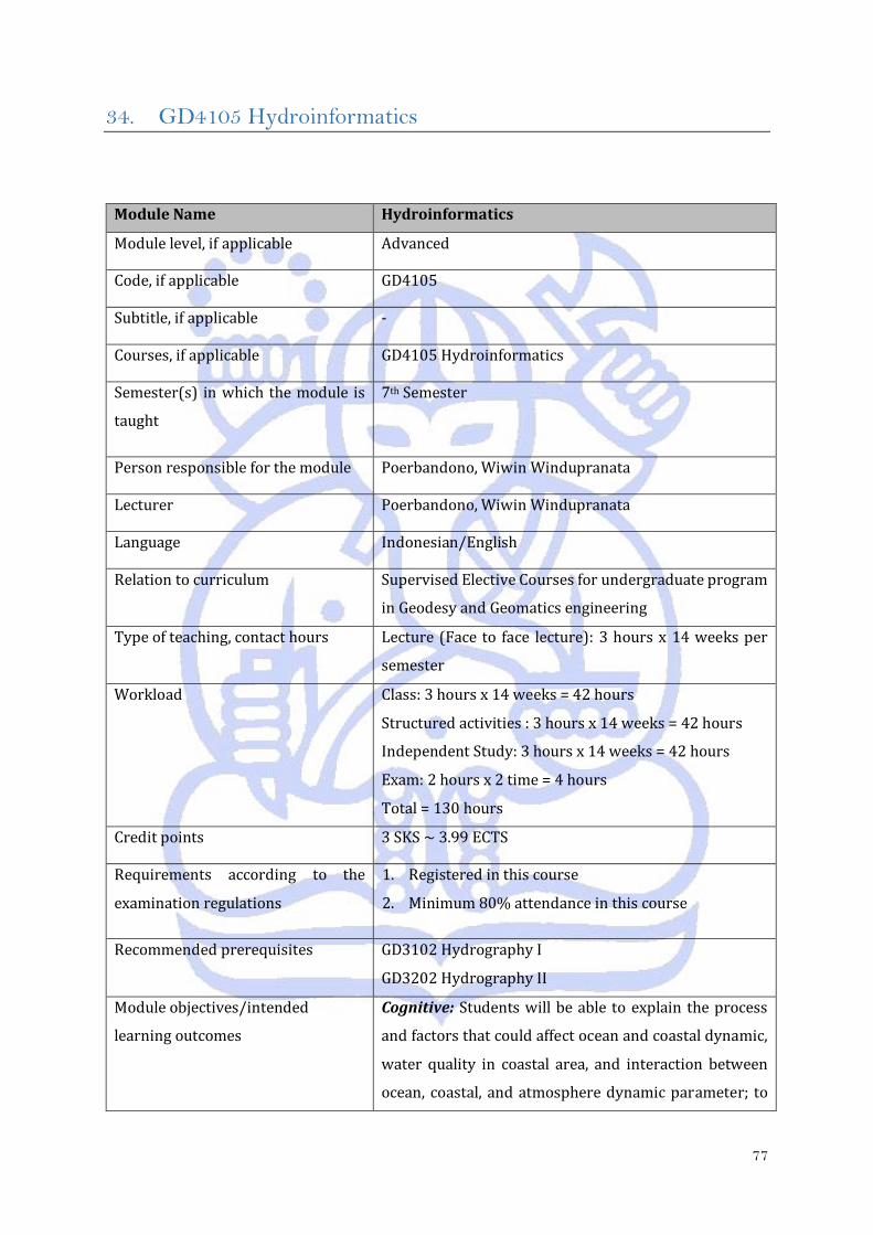
77
34. GD4105 Hydroinformatics
Module Name Hydroinformatics
Module level, if applicable Advanced
Code, if applicable GD4105
Subtitle, if applicable -
Courses, if applicable GD4105 Hydroinformatics
Semester(s) in which the module is
taught
7th Semester
Person responsible for the module Poerbandono, Wiwin Windupranata
Lecturer Poerbandono, Wiwin Windupranata
Language Indonesian/English
Relation to curriculum Supervised Elective Courses for undergraduate program
in Geodesy and Geomatics engineering
Type of teaching, contact hours Lecture (Face to face lecture): 3 hours x 14 weeks per
semester
Workload
Class: 3 hours x 14 weeks = 42 hours
Structured activities : 3 hours x 14 weeks = 42 hours
Independent Study: 3 hours x 14 weeks = 42 hours
Exam: 2 hours x 2 time = 4 hours
Total = 130 hours
Credit points 3 SKS ~ 3.99 ECTS
Requirements according to the
examination regulations
1. Registered in this course
2. Minimum 80% attendance in this course
Recommended prerequisites GD3102 Hydrography I
GD3202 Hydrography II
Module objectives/intended
learning outcomes
Cognitive: Students will be able to explain the process
and factors that could affect ocean and coastal dynamic,
water quality in coastal area, and interaction between
ocean, coastal, and atmosphere dynamic parameter; to
78
understand the design criteria for met ocean study and
to do calculation on metocean study for engineering in
coastal and offshore area purposes; and to apply
numerical approach for modeling hydrodynamics.
1. Student is able to explain parameters involved in
coastal hydrodynamics;
2. Student is able to describe the process of transport
of sediment;
3. Student is able to perform a single metocean
parameter for the purpose of Front End Engineering
Design (FEED);
4. Student is able to define properties of water and
elements of water quality;
5. Student is able to depict factors of regional
oceanography, emphasizing Indonesian water;
6. Student is able to apply numerical tool for simulation
of coastal hydrodynamics.
Psychomotor: Students are able to do work with and
generate information and knowledge from
meteorological and oceanographic dataset for the
purpose of ocean prediction and design criteria.
Affective: Following the general provisions, which is set
by course.
Content
This course contains ocean and coastal dynamics,
metocean study, and numerical modelling. Details of the
content include the process of generation of gravity
wave and its propagation across nearshore zone; the
relation between tide and tidal current, as well as their
observation and analytical description; the
characteristics of hydrodynamics across wave- and tide-
dominated coasts and estuary; the process of erosion,
transport, and deposition of sediment; the approach for
prediction of sediment transport, its observation and
impact on changes of seabed elevation; mean regime
analysis by carrying out descriptive statistical approach
for occurrence analysis; extreme value analysis of a
79
single metocean parameter using Weibull distribution
and plot on Gumbel paper; physical, chemical, and
biological properties of seawater, and their processes
throughout tidal cycle and season; regional, steric, and
synodic effects on Indonesian ocean and its adjacent
region, particularly ENSO and Through Flow; partial
differential equation (PDE) for carrying out modelling of
advection and diffussion of fluids on 2D; construction of
1D calculation using PDE for simulation of changes of
water elevation with time due to tide; construction of
computational domain for simulation of 2D current of a
simple coastal region and perform senstivity analysis;
calibration of tide and current simulation using
observation data and report the result of performance of
2D numerical simulation; and analytical report on tide
and tidal current based on result from calibrated 2D
numerical simulation.
Study and examination
requirements and forms of
examination
Cognitive: assessed from midterms, final exam,
assignments, quizzes
Psychomotor: assessed from practical process
Affective: Assessed from variables of performance,
namely: (a) Focus, (b) Respect, (c) Literacy, and (d)
Contribution.
Media employed Classical teaching tools with white board and power
point presentation
Reading list
1. Garrison T (2008). Essentials of Oceanography. 5th
international ed, Brooks Cole, 464 pp.
2. Masselink G, Hughes MG (2003), Introduction to
Coastal Processes and Geomorphology, Hodder
Arnold Publication, pp. 354
3. Chapra SC (2012) Applied Numerical Methods with
MATLAB for Engineers and Scientists, Third Edition,
Mc GrawHill, 2012
4. Reiss RD, Thomas M (2007) Statistical analysis of
extreme values.

80
Reiß RD, Thomas M (2007) Statistical Analysis of
Extreme Values: with Applications to Insurance,
Finance, Hydrology and Other Fields.
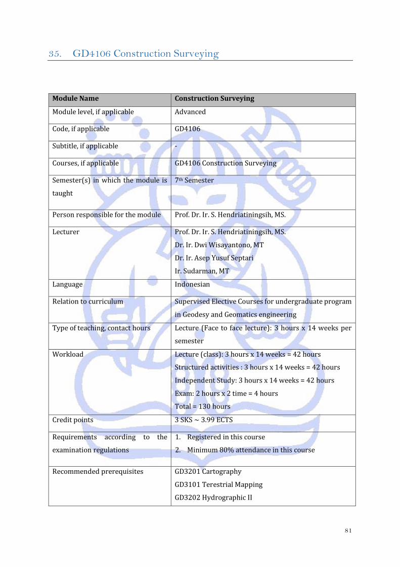
81
35. GD4106 Construction Surveying
Module Name Construction Surveying
Module level, if applicable Advanced
Code, if applicable GD4106
Subtitle, if applicable -
Courses, if applicable GD4106 Construction Surveying
Semester(s) in which the module is
taught
7th Semester
Person responsible for the module Prof. Dr. Ir. S. Hendriatiningsih, MS.
Lecturer
Prof. Dr. Ir. S. Hendriatiningsih, MS.
Dr. Ir. Dwi Wisayantono, MT
Dr. Ir. Asep Yusuf Septari
Ir. Sudarman, MT
Language Indonesian
Relation to curriculum Supervised Elective Courses for undergraduate program
in Geodesy and Geomatics engineering
Type of teaching, contact hours Lecture (Face to face lecture): 3 hours x 14 weeks per
semester
Workload
Lecture (class): 3 hours x 14 weeks = 42 hours
Structured activities : 3 hours x 14 weeks = 42 hours
Independent Study: 3 hours x 14 weeks = 42 hours
Exam: 2 hours x 2 time = 4 hours
Total = 130 hours
Credit points 3 SKS ~ 3.99 ECTS
Requirements according to the
examination regulations
1. Registered in this course
2. Minimum 80% attendance in this course
Recommended prerequisites
GD3201 Cartography
GD3101 Terestrial Mapping
GD3202 Hydrographic II

82
GD3203 Photogrametry II
Module objectives/intended
learning outcomes
Cognitive: Students are able to explain about setting out
points in engineering survey.
Psychomotor: Students are able to do and implement
setting out in the field.
Affective: Students are able to follow the rules of
courses.
Content
- Route surveying, horizontal & vertical curvature,
grade/slope
- Setting out horizontal points
- Setting out circle from TC/CT
- Setting out circle from CC, PI, and O
- Spiral and transition Curve
- Setting out spiral
- Symmetric and asymmetric vertical curve
- Setting out vertical points
- Define area in the field
- Earthwork
Study and examination
requirements and forms of
examination
Cognitive: assessed from midterms, final exam,
assignments, quizzes
Psychomotor: assessed from practical process
Affective: assessed from prestige note
elements/variables, which are: (a) Contributions
(attendance, activeness, roles, inisiative, language), (b)
Appreciation of time, (c) Effort
Media employed Classical teaching tools with white board and power
point presentation
Reading list 1. Barry F Kavanagh,1997, Surveying with
Construction Applications, Prentice Hal,Inc
2. W.Schofield, 1998, Engineering Surveying,
Butterworth-Heinemann.
3. William Irvine,1995, Surveying For Construction,
McGraw-Hill Book Company.
83
36. GD4107 Selected Topics
Module Name Selected Topics
Module level, if applicable Advanced
Code, if applicable GD4107
Subtitle, if applicable Spatial Data Infrastructure
Courses, if applicable GD4107 Selected Topics
Semester(s) in which the module is
taught
7th Semester
Person responsible for the module Agustinus Bambang Setyadji, Rizqi Abdulharis
Lecturer Agustinus Bambang Setyadji, Rizqi Abdulharis
Language Indonesian
Relation to curriculum Directed elective modul for undergraduate program in
Geodesy and Geomatics engineering
Type of teaching, contact hours
Type of teaching: Face to face lecture, literature review,
workshop
Contact hours: 9 hours x 14 weeks per semester
Workload
Class: 3 hours x 14 weeks = 42 hours
Structured activities : 3 hours x 14 weeks = 42 hours
Independent Study: 3 hours x 14 weeks = 42 hours
Exam: 2 hours x 2 time = 4 hours
Total = 130 hours
Credit points 3 SKS ~ 3.99 ECTS
Requirements according to the
examination regulations
1. Registered in this course
2. Minimum 80% attendance in this course
Recommended prerequisites -
Module objectives/intended
learning outcomes
Cognitive: Students are able to demonstrate advanced
understanding on Spatial Data Infrastructure; as well as
its application throughout the world and in Indonesia
84
Psychomotor : Students are able to apply her/his
knowledge on the above mentioned concept to
recommend solution(s) to geospatial-related complex
problem(s)
Affective: Students are actively developing
comprehension on the above mentioned concept and its
application, contributing to activities during
implementation of module, and following the rules of the
module
Content
Concept, policy, standard, technology, institutional
aspect, and application of Spatial Data Infrastructure
Study and examination
requirements and forms of
examination
Cognitive: Midterm exam, final exam, quizzes,
assignments, workshop presentation
Psychomotor: Workshop presentation
Affective: Assignments, workshop presentation,
contributions (activeness, initiative, language), being on
time, and effort.
Media employed
Classic Visual media namely white board and projector,
references such as books, papers, regulations, and other
types of online publications al teaching tools with white
board and power point presentation
Reading list
1. Nebert, D. Douglas (2012). Developing Spatial Data
Infrastructure: The SDI Cookbook version 2.0.
Retrieved on 1 August 2013 from
2. http://gsdiassociation.org/images/publications/
cookbooks/SDI_Cookbook_from_Wiki_2012_
update.pdf
85
37. GD4203 Quantity Surveying
Module Name Quantity Surveying
Module level, if applicable Advanced
Code, if applicable GD4203
Subtitle, if applicable -
Courses, if applicable GD4203 Quantity Surveying
Semester(s) in which the module is
taught
7th Semester
Person responsible for the module Bambang Edhi Leksono S; ; Irawan Soemarto
Lecturer
Bambang Edhi Leksono S.; Asep Yusup Saptari; Irawan
Soemarto; Sella Lestari Nurmaulia
Language Indonesian
Relation to curriculum Supervised Elective Courses for undergraduate program
in Geodesy and Geomatics engineering
Type of teaching, contact hours
Type of teaching: In-class lecture, literature review, and
workshop
Contact hour: 9 hours x 14 weeks per semester
Workload
Class: 3 hours x 14 weeks = 42 hours
Structured activities : 3 hours x 14 weeks = 42 hours
Independent Study: 3 hours x 14 weeks = 42 hours
Exam: 2 hours x 2 time = 4 hours
Total = 130 hours
Credit points 3 SKS ~ 3.99 ECTS
Requirements according to the
examination regulations
1. Registered in this course
2. Minimum 80% attendance in this course
Recommended prerequisites GD4102 Cadastre System
Module objectives/intended
learning outcomes
Cognitive: Students are able to demonstrate analytical
thinking on land and building surveying and valuation
86
and real estate management; as well as their
procurement process and legal aspect
Psychomotor: Students are able to perform
procurement process and simulate land and building
surveying and valuation and real estate management
Affective: Students are actively developing
comprehension on the above mentioned concept and its
application, contributing to activities during
implementation of module, and following the rules of the
module
Content
- Land and building surveying
- Land and building valuation
- Real estate management
- Legal aspect of land and building surveying and
valuation and real estate management
- Procurement process on land and building
surveying and valuation
Study and examination
requirements and forms of
examination
Cognitive: Midterm exam, final exam, quizzes,
assignments, workshop presentation
Psychomotor: Workshop presentation
Affective: Assignments, workshop presentation,
contributions (activeness, initiative, language), being on
time, and effort.
Media employed
Visual media namely white board and projector,
references such as books, papers, regulations, and other
types of online publications
Reading list
1. Seeley IH. (1997). Quantity Surveying Practice, 2nd
Revised Macmillan; ISBN 978-0-333-68907-3
2. Seeley IH. (1998). Building Quantities Explained 5th
Revised edition, Macmillan ISBN 978-0-333-71972-
5
3. Lee S. Trench W. Willis A. (2005) Elements of
Quantity Surveying. 10th Edition WileyBlackwell;
ISBN 978-1-4051-2563-5

87
4. Ashworth A. Hogg K. (2007). Willis’s Elements of
Quantity Surveying 12 Rev Ed edition Blackwell
Publishing. ISBN 978-1-4051-4578-7.
88
38. GD4204 Deformation
Module Name Deformation
Module level, if applicable Advanced
Code, if applicable GD4204
Subtitle, if applicable -
Courses, if applicable GD4204 Deformation
Semester(s) in which the module is
taught
4th Semester
Person responsible for the module Dina Anggreni Sarsito; Irwan Meilano
Lecturer Dina Anggreni Sarsito; Heri Andreas; Irwan Meilano;
Irwan Gumilar
Language Indonesian
Relation to curriculum Supervised Elective Courses for undergraduate program
in Geodesy and Geomatics engineering
Type of teaching, contact hours Lecture (Face to face lecture): 3 hours x 14 weeks per
semester
Workload
Class: 3 hours x 14 weeks = 42 hours
Structured activities : 3 hours x 14 weeks = 42 hours
Independent Study: 3 hours x 14 weeks = 42 hours
Exam: 2 hours x 2 time = 4 hours
Total = 130 hours
Credit points 3 SKS ~ 3.99 ECTS
Requirements according to the
examination regulations
1. Registered in this course
2. Minimum 80% attendance in this course
Recommended prerequisites -
Module objectives/intended
learning outcomes
Cognitive: Students will have the knowledge and ability
to monitor the dynamics of the earth, especially
deformation phenomena using geodetic methods
89
Psychomotor: After attending this course, students are
able to explain how to monitor and analyze the
phenomenon of earth dynamics and deformation using
geodetic methods and understand the basic idea in
deformation models.
Affective: Following the rules of the lecture courses.
Content
This course provides the students comprehensive
knowledge on application of geodesy for studying the
Earth dynamic and deformation including its design and
geodetic measurements as well as deformation analysis.
Including Introduction, Basic deformation theory,
Deformation monitoring technology, Deformation
phenomena.
Study and examination
requirements and forms of
examination
Cognitive: assessed from mid test, final exam, Tasks,
Quiz
Psychomotor: assessed from the laboratory
Affective: assessed from the elements / achievement
variables: (a) Contributions (attendance, active, role,
initiative, and language), (b) Respect for the time, (c)
Business.
Media employed Classical teaching tools with white board and power
point presentation
Reading list
1. Turcotte D.L., Schubert G., :Geodynamics, 3rd
edition, 2014
2. Caspary, W.F.,: Concepts of Network and
Deformation analysis, monograph 11, School of
Surveying UNSW, Kensington, NSW, Australia 1987.
3. Fowler, C.M.,: The Solid Earth: Introduction to Global
Geophysics, Cambridge University Press, 1993.
4. Kuang, S: Geodetic Network Analysis and Optimal
Design: Concepts and Applications, Ann Arbor Press,
Inc, 1996.
5. Lambeck, K: Geophysical Geodesy: The Slow
Deformation of The Earth, Claredon Press, Oxford,
1998.
90
6. Dzurisin, D: Volcano Deformation: Geodetic
Monitoring techniques, Springer , 2007.
91
39. GD4205 Maritime Boundaries
Module Name Maritime Boundaries
Module level, if applicable Advanced
Code, if applicable GD4205
Subtitle, if applicable -
Courses, if applicable GD4205 Maritime Boundaries
Semester(s) in which the module is
taught
4th Semester
Person responsible for the module Eka Djunarsjah; Heri Andreas
Lecturer Eka Djunarsjah; Heri Andreas
Language Indonesian
Relation to curriculum
Supervised Elective Courses for undergraduate program
in Geodesy and Geomatics engineering
Type of teaching, contact hours Lecture (Face to face lecture): 3 hours x 14 weeks per
semester
Workload
Class: 3 hours x 14 weeks = 42 hours
Structured activities: 3 hours x 14 weeks = 42 hours
Independent Study: 3 hours x 14 weeks = 42 hours
Exam: 2 hours x 2 time = 4 hours
Total = 130 hours
Credit points 3 SKS ~ 3.99 ECTS
Requirements according to the
examination regulations
1. Registered in this course
2. Minimum 80% attendance in this course
Recommended prerequisites GD 2206 Geospatial Law and Regulations
Module objectives/intended
learning outcomes
Students are able to understand the concept of maritime
delimitation both nationally and internationally, to
understand and analyze the problems, and to
92
understand the marine cadaster current issue in
Indonesia
Content
This course content maritime boundaries and related to
marine cadaster, including definition and concept of
baseline, international and national maritime zone
characteristics, national and international maritime
boundaries delimitation, marine cadaster, case study for
maritime boundaries and marine cadaster.
Study and examination
requirements and forms of
examination
Cognitive: assessed from mid test, final exam, Tasks,
Quiz
Psychomotor: assessed from the laboratory
Affective: assessed from the elements / achievement
variables: (a) Contributions (attendance, active, role,
initiative, language), (b) Respect for the time, (c)
Business.
Media employed
Classical teaching tools with white board and power
point presentation
Reading list
1. BPN-RI, Prosedur Pengukuran Ruang Perairan, 2011
2. Djunarsjah, E., Aspek Teknis Hukum Laut, Penerbit
ITB Bandung, 2007
3. IHO, S-51 Technical Aspects of the Law of the Sea,
2006
4. Kemendagri-RI, Pedoman Penegasan Batas Daerah,
2012
5. United Nations, The Convention of the Law of the Sea,
1983
93
40. GD4206 Engineering of Geographic Information System
Module Name Engineering of Geographic Information System
Module level, if applicable Advanced
Code, if applicable GD4206
Subtitle, if applicable -
Courses, if applicable GD4206 Engineering of Geographic Information System
Semester(s) in which the module is
taught
8th Semester
Person responsible for the module Albertus Deliar; Deni Suwardhi
Lecturer Albertus Deliar; Riantini Virtriana; Deni Suwardhi; Alfita
Puspa Handayani
Language Indonesian
Relation to curriculum Supervised Elective Courses for undergraduate program
in Geodesy and Geomatics engineering
Type of teaching, contact hours Lecture (Face to face lecture): 3 hours x 14 weeks per
semester
Workload
Class: 3 hours x 14 weeks = 42 hours
Structured activities : 3 hours x 14 weeks = 42 hours
Independent Study: 3 hours x 14 weeks = 42 hours
Exam: 2 hours x 2 time = 4 hours
Total = 130 hours
Credit points 3 SKS ~ 3.99 ECTS
Requirements according to the
examination regulations
1. Registered in this course
2. Minimum 80% attendance in this course
Recommended prerequisites GD 4101 Geospatial Information System
Module objectives/intended
learning outcomes
Cognitive: Students understand and able to explain the
methods of spatial analysis in GIS model development.
Psychomotor: Students are able to perform spatial
modeling with GIS.
94
Affective: Following the rules of the lecture courses.
Content
This course will give the knowledge about basic principle
of GIS modelling, integrated GIS by using statistics
methods, and the future of GIS.
GIS review, surface analysis, advanced analysis, non-
spatial database analysis, procedure analysis, site
selection analysis, trend analysis, GIS model, GIS design,
Spatial decision support system, Web GIS and pilot
project.
Study and examination
requirements and forms of
examination
Cognitive: assessed from mid test, final exam, Tasks,
Quiz
Psychomotor: assessed from the laboratory
Affective: assessed from the elements / achievement
variables, : (a) Contributions (attendance, active, role,
initiative, language), (b) Respect for the time, (c)
Business
Media employed Classical teaching tools with white board and power
point presentation
Reading list
1. Michael Zeiler (1999). Modeling Our World, ESRI
Press.
2. Chou, T.H. (1997), Exploring Spatial Analysis in
Geographic Information Systems, Onword Press,
Santa Fe.
3. Christman, N. (1997), Exploring Geographic
Information Systems, John Wiley and Sons, New York.
95
41. GD4207 Marine Geodesy
Module Name Marine Geodesy
Module level, if applicable Advanced
Code, if applicable GD4207
Subtitle, if applicable -
Courses, if applicable GD4207 Marine Geodesy
Semester(s) in which the module is
taught
8th Semester
Person responsible for the module Dina Anggreni Sarsito; Dudy Darmawan Wijaya
Lecturer Dina Anggreni Sarsito; Vera Sadarviana; Dudy
Darmawan Wijaya; Zamzam Akhmad Jamaluddin T.
Language Indonesian
Relation to curriculum Supervised Elective Courses for undergraduate program
in Geodesy and Geomatics engineering
Type of teaching, contact hours Lecture (Face to face lecture): 2 hours x 14 weeks per
semester
Workload
Class: 2 hours x 14 weeks = 28 hours
Structured activities : 2 hours x 14 weeks = 28 hours
Independent Study: 2 hours x 14 weeks = 28 hours
Exam: 2 hours x 2 time = 4 hours
Total = 88 hours
Credit points 2SKS ~ 2.66 ECTS
Requirements according to the
examination regulations
1. Registered in this course
2. Minimum 80% attendance in this course
Recommended prerequisites -
Module objectives/intended
learning outcomes
Cognitive: Students are able to explain how to do a
positioning, bathymetry profile determination and
gravity of the earth in the sea area using geodetic
technologies (including satellite technology)
96
Psychomotor: Students are able to calculate the position
detailing and make bathymetry profiles also calculate
gravity in the sea area.
Affective: Following the rules of the lecture courses
Content
This course deals with the role of geodesy in marine
environment. The course subjects includes precise
positioning, seabed mapping, and earth’s gravity field
determination by using the most recent technology.
Including, Introduction; Geodetic frame and reference
system review, Observables; Precise positioning
techniques; Satellite geodesy in marine environment;
Sea surface topography determination; Thematic Map
and Marine geodesy application status.
Study and examination
requirements and forms of
examination
Cognitive: assessed from mid test, final exam, Tasks,
Quiz
Psychomotor: assessed from the laboratory
Affective: assessed from the elements / achievement
variables, : (a) Contributions (attendance, active, role,
initiative, language), (b) Respect for the time, (c)
Business
Media employed Classical teaching tools with white board and power
point presentation.
Reading list
1. Jekely, C : Geometric Reference Systems in Geodesy,
Division of Geodesy and Geospatial Science, School
of Earth Sciences, Ohio State University.2006
2. Torge, W and Muller, J: Geodesy, Walter De Gruyter.
2012
3. Seeber, Gunter : Satellite Geodesy, Foundation,
Methods, and Applications, Walter de Gruyter Berlin.
New York. 1993
4. Fu, L.L and A Cazenave : Satellite altimetri and earth
science, Academic Press, 2001.