ismail ehe mat-zin - wordpress.comtectonics evolution and sedimentation history of the sarawak basin...
TRANSCRIPT
Petroleum Geology Conference '96 Decemher 9-10, 1996, KwJa Lumpur
Tectonics evolution and sedimentation history of the Sarawak Basin
ISMAIL eHE MAT-ZIN
PETRONAS Carigali Sdn. Bhd. 25th Floor Menara 1, Petronas Twin Towers
Jalan P. Ramlee, off Jalan Ampang Kuala Lumpur
Abstract: A seismic stratigraphic study of the reprocessed regional lines for the offshore Sarawak area was undertaken with the aim of reviewing the present understanding of the tectonics and the palaeodepositional environments of the Sarawak Basin. The study was integrated with biostratigraphy and wireline log data from the wells drilled throughout the basin.
Seven unconformities were identified within the Tertiary sediments and these were used as the markers for the seismic correlations. Where the unconformities become conformable, well data were used to guide the correlation of the conformities. Palaeo-environment maps were generated which document the interaction of tectonics and sediments throughout the basin history. The development of the Sarawak Basin commenced in late Oligocene times with deposition along a coastline running in a NW-SE direction, which is almost perpendicular to the present day coastline. The coastline was oriented to the present day NE-SW during late Miocene times.
The study also revealed that the Sarawak Basin was formed as a result of NW-SE trending right lateral fault movement during late Oligo-Miocene times. This dextral movement was responsible for creating the earlier NW-SE coastline and divided the offshore Sarawak area into two sub-basins. Deposition and preservation of coastal plain and shallow marine sediments continued in the eastern area while the western area remained as a 'high' until late Miocene times. The dextral strike-slip movement which controlled the evolution of the Sarawak Basin is sub-parallel to a number of lineaments elsewhere in Sarawak. The timing of movement of these suggests progressive younging in an eastward direction. It is also believed the late structuration of the sediments and the formation of structural traps is linked to these tectonic movements.
INTRODUCTION
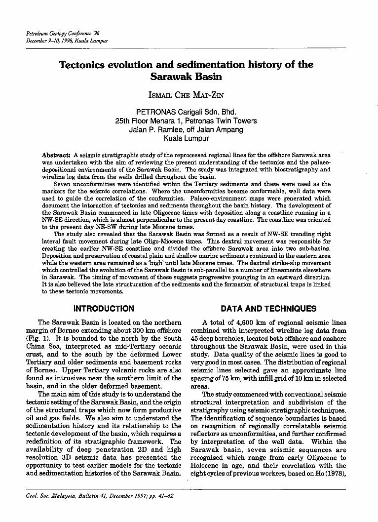
The Sarawak Basin is located on the northern margin of Borneo extending about 300 km offshore (Fig. 1). It is bounded to the north by the South China Sea, interpreted as mid-Tertiary oceanic crust, and to the south by the deformed Lower Tertiary and older sediments and basement rocks of Borneo. Upper Tertiary volcanic rocks are also found as intrusives near the southern limit of the basin, and in the older deformed basement.
The main aim of this study is to understand the tectonic setting of the Sarawak Basin, and the origin of the structural traps which now form productive oil and gas fields. We also aim to understand the sedimentation history and its relationship to the tectonic development of the basin, which requires a redefinition of its stratigraphic framework. The availability of deep penetration 2D and high resolution 3D seismic data has presented the opportunity to test earlier models for the tectonic and sed.i.JDentation histories of the Sarawak Basin.
GeoL. Soc. MalaY.lia, Bulletin 41, Decem6er 1997; pp. 41-52
DATA AND TECHNIQUES
A total of 4,600 km of regional seismic lines combined with interpreted wireline log data from 45 deep boreholes, located both offshore and onshore throughout the Sarawak Basin, were used in this study. Data quality of the seismic lines is good to very good in most cases. The distribution of regional seismic lines selected gave an approximate line spacing of 75 km,.with infill grid of 10 km in selected areas.
The study commenced with conventional seismic structural interpretation and subdivision of the stratigraphy using seismic stratigraphic techniques. The identification of sequence boundaries is based on recognition of regionally correlatable seismic reflectors as unconformities, and further confirmed by interpretation of the well data. Within the Sarawak basin, seven seismic sequences are recognised which range from early Oligocene to Holocene in age, and their correlation with the eight cycles of previous workers, based on Ho (1978),
~ <::. :--.
~ !'
~ s-~ ~.
t::I:! !::
~ ..,. s· ~
SK8
SKI SIG SKIO
-SK2 SK4
SKI2
SKI9 SARAWAK
~ (/;l·~~
SKI7
Usun ~ Apau PlateaY
KALIMANTAN
o 50 IOOkm I I I
-
Figure 1. Map showing the present concession blocks in the Sarawak Basin and the location of the study area.
~ I\:)
f F (') :::c m
~ Z
TECTONICS EVOLUTION AND SEDIMENTATION HISTORY OF THE SARAWAK BASIN 43
CIIS ::; ~
~ ..... Eo-
5
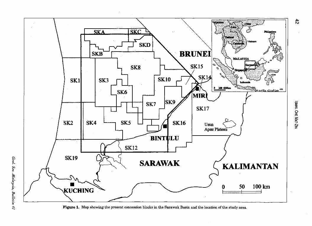
is shown in Figure 2. A series of structure maps were created at Top
Basement (Fig. 3) and at each of the major unconformities recognised regionally across the basin. These were used to create isochore maps of each sequence, which indicated the relative thickness with respect to the fault pattern. Analysis ofthe available well data has allowed us to develop a series of palaeogeographic maps for each of the sequences recognised. The stability of the sedimentological regime through the sedimentation history allo·ws us to comment briefly on the likely distribution of reservoirs and source rocks.
S Original Proposed
<I> Cycle Sequence = ~ EPOCH J-o = Boundaries Stratigrahic <:) <:) Boundaries ~ N (Ho.1978)
VIU T7S
VII T6S
T5S VI
N17
T4S LATE
N16
~ T2S
~ N5 uJ
N4
Ul ;z: P22 TIS ....,
8 Ul
::; :s 0 P21
Figure 2. Stratigraphic scheme used for the Sarawak Basin. The Tertiary succession in the basin was subdivided by Ho (1978) into eight cycles. The base of each cycle is marked by the maximum transgressive unit and the top is represented the maximum regressive unit. The subdivision proposed in this study is based on the recognition of regional unconformities.
December 1997
TECTONIC AND SEDIMENTARY DEVELOPMENT OF THE SARAWAK
BASIN
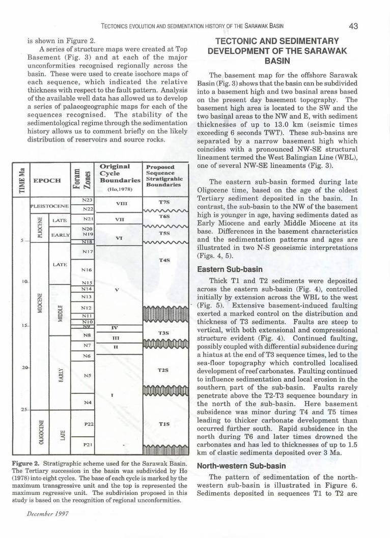
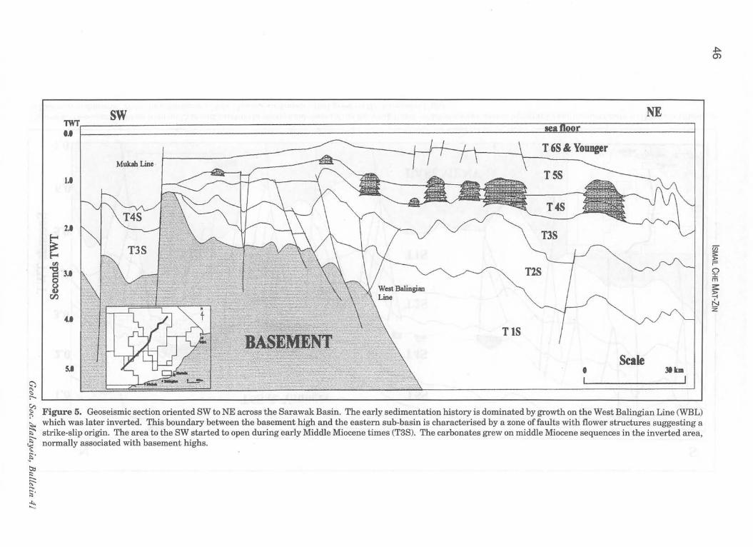
The basement map for the offshore Sarawak Basin (Fig. 3) shows that the basin can be subdivided into a basement high and two basinal areas based on the present day basement topography. The basement high area is located to the SW and the two basinal areas to the NW and E, with sediment thicknesses of up to 13.0 km (seismic times exceeding 6 seconds TWT). These sub-basins are separated by a narrow basement high which coincides with a pronounced NW-SE structural lineament termed the West Balingian Line (WBL), one of several NW-SE lineaments (Fig. 3).
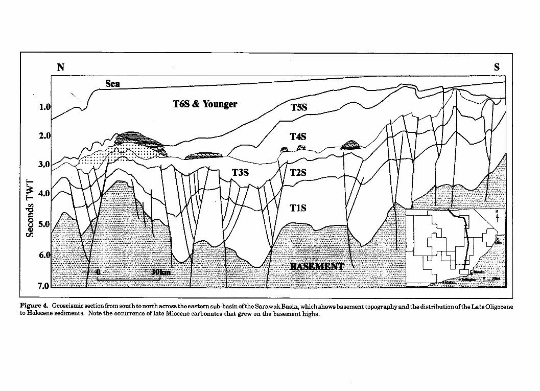
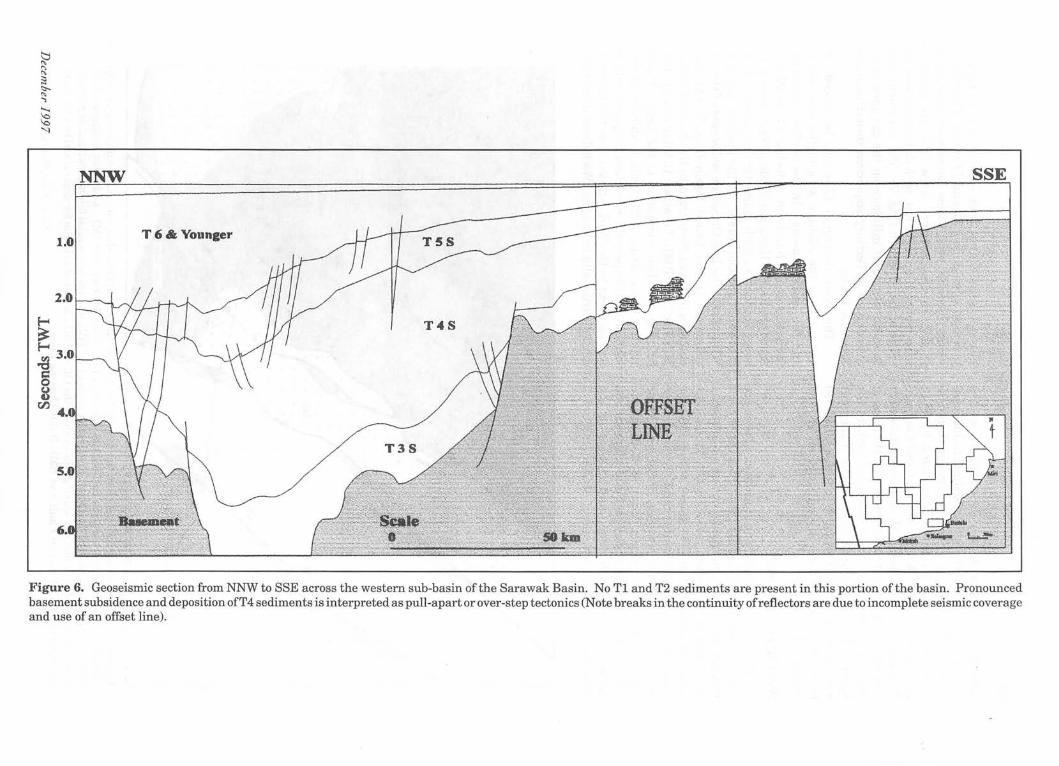
The eastern sub-basin formed during late Oligocene time, based on the age of the oldest Tertiary sediment deposited in the basin. In contrast, the sub-basin to the NW of the basement high is younger in age, having sediments dated as Early Miocene and early Middle Miocene at its base. Differences in the basement characteristics and the sedimentation patterns and ages are illustrated in two N-S geoseismic interpretations (Figs. 4, 5).
Eastern SUb-basin
Thick T1 and T2 sediments were deposited across the eastern sub-basin (Fig. 4), controlled initially by extension across the WBL to the west (Fig. 5). Extensive basement-induced faulting exerted a marked control on the distribution and thickness of T3 sediments. Faults are steep to vertical, with both extensional and compressional structure evident (Fig. 4). Continued faulting, possibly coupled with differential subsidence during a hiatus at the end of T3 sequence times, led to the sea-floor topography which controlled localised development of reef carbonates. Faulting continued to influence sedimentation and local erosion in the southern part of the sub-basin. Faults rarely penetrate above the T2-T3 sequence boundary in the north of the sub-basin. Here basement subsidence was minor during T4 and T5 times leading to thicker carbonate development than occurred further south. Rapid subsidence in the north during T6 and later times drowned the carbonates and has led to thicknesses of up to 1.5 km of clastic sediments deposited over 3 Ma.
North-western Sub-basin
The pattern of sedimentation of the northwestern sub-basin is illustrated in Figure 6. Sediments deposited in sequences T1 to T2 are
~ <:> :-...
~ !'
~ f ~.
~ ;::
~ ..,. s· ~
SK4
1.0
• Miri
o 50km I
Figure 3. Basement topography map and the major structura1lineaments in the Sarawak Basin, interpreted as dextral strike-Rlip faultR . Contours are for seconds of two-way time. Area in yellow is basement high and the areas in blue are structural lows.
~ ~
Cii s:: » r= (") I m s::: ~ N z
~ ~ § o u
tI..l
N
"
s Sea
T6S & Younger
Figure 4. Geoseismic section from south to north across the eastern sub-basin ofthe Sarawak Basin, which shows basement topography and the distribution of the Late Oligocene to Holocene sediments. Note the occurrence oflate Miocene carbonates that grew on the basement highs.
~ <::> r---
TWr SW ... '
Mubh Line ,
1.1
2.'
~ 1" en
...
SJ
NE ADa. ftnn •
T 6S &. Younger
TSS
T4S
T3S
Scale 3t .". '1 I
~ Figure 5. Geoseismic section oriented SW to NE across the Sarawak Basin, The early sedimentation history is dominated by growth on the West Balingian Line (WBL) ~ which was later inverted. This boundary between the basement high and the eastern sub-basin is characterised by a zone offaults with flower structures suggesting a ~ strike-slip origin. The area to the SW started to open during early Middle Miocene times (T3S). The carbonates grew on middle Miocene sequences in the inverted area, ~ normally associated with basement highs . ... -?" tb ;::: ...... ~ ..,. ;;.
~
.J:>. Q)
en s: :» r= (") ::r: m ;s:: ~ N z
~ R ;3 <:>-
" ..., ...... ~ '1
~ ~
] ~
tI.l
s
1.0 T6& Younger
Figure 6. Geoseismic section from NNW to SSE across the western sub-basin of the Sarawak Basin. No Tl and T2 sediments are present in this portion of the basin. Pronounced basement subsidence and deposition ofT4 sediments is interpreted as pull-apart or over-step tectonics (Note breaks in the continuity of reflectors are due to incomplete seismic coverage and use of an offset line).
48 ISMAIL CHE MAT-ZIN
absent. T3 sediments are deposited across the basement, with local changes in sediment thickness controlled by faulting. However, major thickness changes occur in T4 times, controlled by fault activity on both the WBL to the east and the IganOya Line (Fig. 3) to the south and west. Basement control is still evident in T5 times with thinning of the sediments onto a local basement high to the NNW. However there was strong basement subsidence occurred from south to north, which led to thick accumulations of sediment of T6 and younger (last 3 Ma).
West Balingian Line
The basement and the eastern basinal area are separated by the WBL fault zone. This major fault zone trends NW-SE, similar to known major strikeslip faults in the region including the Tinjar Line (Tan and Lamy, 1990). The faults within the zone are characterised by variable fault throw and age of fault movement along strike. Features include negative flower structures, local fault inversion, evidence in the stratigraphy for both extension and compression through time, and change in the direction of fault throw along strike. Figure 5
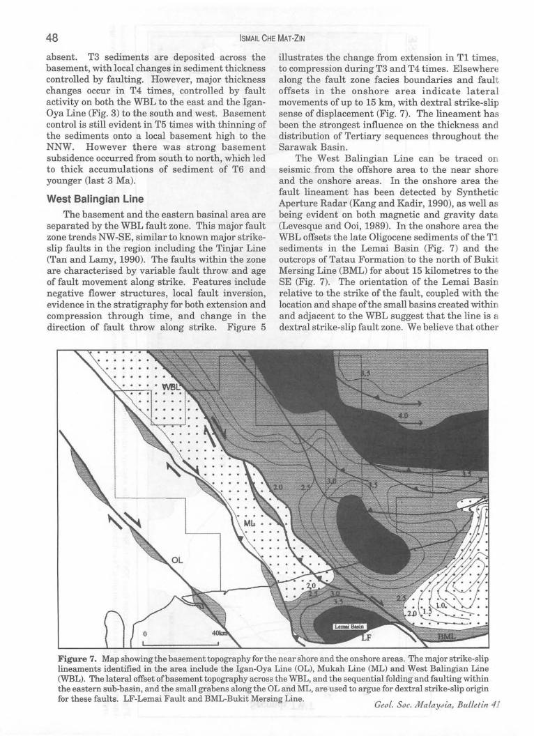
illustrates the change from extension in Tl times, to compression during T3 and T4 times. Elsewhere along the fault zone facies boundaries and fault offsets in the onshore area indicate lateral movements of up to 15 km, with dextral strike-slip sense of displacement (Fig. 7). The lineament has been the strongest influence on the thickness and distribution of Tertiary sequences throughout the Sarawak Basin.
The West Balingian Line can be traced on seismic from the offshore area to the near shore and the onshore areas. In the onshore area the fault lineament has been detected by Synthetic Aperture Radar (Kang and Kadir, 1990), as well as being evident on both magnetic and gravity dat (Levesque and Ooi, 1989). In the onshore area the WBL offsets the late Oligocene sediments of the T1 sediments in the Lemai Basin (Fig. 7) and the outcrops of Tatau Formation to the north of Bukit Mersing Line (BML) for about 15 kilometres to the SE (Fig. 7). The orientation of the Lemai Basin relative to the strike of the fault, coupled with the location and shape of the small basins created within and adjacent to the WBL suggest that the line is a dextral strike-slip fault zone. We believe that other
Figure 7. Map showing the basement topography for the near shore and the onshore areas. The major strike-slip lineaments identified in the area include the Igan-Oya Line (OL), Mukah Line (ML) and West Balingian Line (WBL). The lateral offset of basement topography across the WBL, and the sequential folding and faulting within the eastern sub-basin, and the small grabens along the OL and ML, are used to argue for dextral strike-slip origin for these faults. LF-Lemai Fault and BML-Bukit Mersing Line.
GeoL. Soc. MaLaYdia, BuLLetin 41
TECTONICS EVOLUTION AND SEDIMENTATION HISTORY OF THE SARAWAK BASIN 49
sub-parallel lineaments, such as the Mukah Line and Igan Oya Line (Figs. 3,7), also originated due to dextral strike-slip tectonics.
It is known that the West Balingian Line started to form during Eocene-Oligocene times, based on the oldest sediment wh.ich abuts the fault. The timing of onset of fault movement relates to the opening of the South China Sea, (Briais et al., 1993) where the earliest oceanic crust is dated as 32 Ma (Mid-Oligocene). The WBL was initially active with net extension until early Miocene times, and reactivated with compression dominant thereafter (Fig. 5). It is also believed that the Mukah Line was formed in late Oligocene time, and reactivated during middle Miocene. The line also appears to be a dominant control on the deposition of the early Tertiary sediments in the Sarawak Basin. The line formed as the western boundary for the deposition of the late Oligocene (T1) sediments.
Other NW-SE Fault Lineaments Further to the East, in the vicinity of Miri, two
other lineaments have been identified, called the Tinjar Line and West Baram Line (Fig. 3). The Tinjar line is interpreted to be formed in Late Miocene times (T4) and continued to late Pliocene (T6). The line continued to the onshore area, where James (1984), Hutchison (1988) and Tan and Lamy (1990) interpreted the line as a dextral strike-slip fault. In the subsurface the line is characterised by a negative flower structure, also suggesting strikeslip fault origin. The West Baram Line almost parallel to the Tinjar line. The deep depression evident at Top Basement (Fig. 3) could have originated as a pull-apart or over-step basin by dextral strike-slip movements.
The West Baram Line extends landward, passing through to the east of the Usun Apau Plateau (Fig. 1). In this area there is a lateral offset to the south-east Qf the Oligocene-Miocene Setap Shale, based on the surface geological map (Hing, 1992). We also note that the line is coincident with major changes in the axes of anticlines and synclines in the onshore Tertiary sedimentary formations.
The West Baram Line marks the shelf-edge margin and eastern boundary of the Sarawak Basin. The water depth changes abruptly across the fault zone, from about 50 metres to 1,000 metres within a distance of only about 50 km from the West Baram Line (refer also Agostinelli et al., 1990). The line also marks the western boundary of the Sabah Trough (Tan and Lamy, 1990). We do not interpret the Baram Delta as part of the Sarawak Basin, but include it with the Sabah Basin.
December 1997
DISCUSSIONS
Structural Traps We believe that the formation of the Sarawak
Basin was strongly influenced by right lateral strikeslip movement that has taken place during Late Oligocene-Miocene times, involving both extension and compression. The West Balingian Line is the most prominent fault zone which has subdividing the basin into two main sub-basins. The timing of movement of these faults, based on the stratigraphy, suggests progressive younging in an easterly direction, with the latest movements in the Baram area to the east of the Sarawak Basin as late as Pliocene times. These faults are mainly NW-SE in orientation.
The strike-slip tectonism is responsible for the generation of the structural traps in the Sarawak Basin. Most of the wells drilled to date in the basin have been located on structural highs with T1 clastic sediments and T3 carbonates as the principal targets. In the nearshore area the main target is T1 clastics, with structures are broadly coincident with the compressional folding and faulting (Fig. 7) which occurred during early to middle Miocene (T2 and T3) times. We interpret the structural origin of these fold/faults, which produce a distinctive fan shape, as sequential folding (Woodcock and Fisher, 1985) related to dextral strike-slip movement along the WBL.
The en-echelon folds formed along the strikeslip lines have produced relatively small structures. In the deeper water area (Luconia Province of James, 1984), carbonate reefs are the main target for gas exploration and production. The origin of the structures here are principally related to inversion associated with the strike-slip tectonism. In addition, there may be a component of structural development due to differential subsidence (compactional drape) over both earlier formed inversion features, and basement topography.
Palaeogeography and Major Fault Lineaments
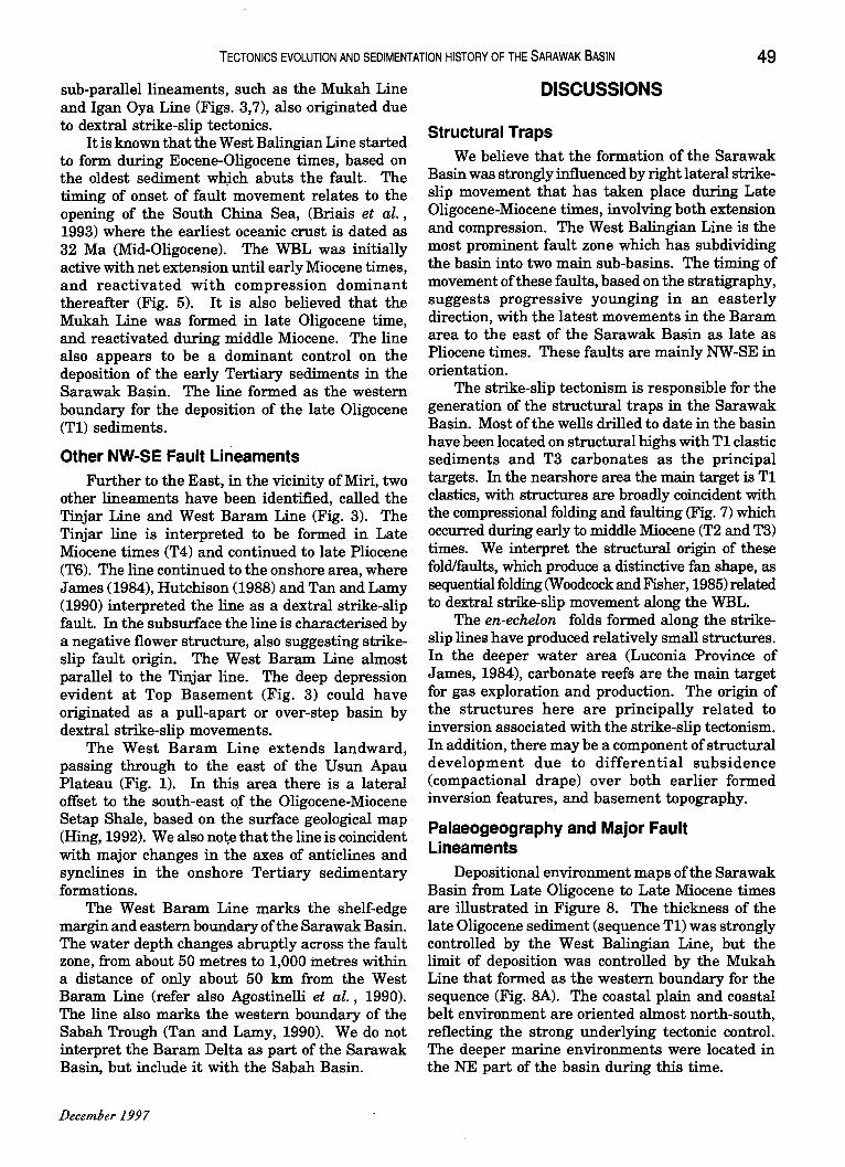
Depositional environment maps of the Sarawak Basin from Late Oligocene to Late Miocene times are illustrated in Figure 8. The thickness of the late Oligocene sediment (sequence T1) was strongly controlled by the West Balingian Line, but the limit of deposition was controlled by the Mukah Line that formed as the western boundary for the sequence (Fig. 8A). The coastal plain and coastal belt environment are oriented almost north-south, reflecting the strong underlying tectonic control. The deeper marine environments were located in the NE part of the basin during this time.
~
A
c
B
o
No p~
Figure 8. Depositional en ·t ullfucnL ill ps of the Sara ak Basil from LaLe Oliguccllc Lu Laic MiUl:elle. Figure SA-LaLe OligUl:ene (TIS), 8B-Early Miocene (T2S), 8C-Middle Miocene (T3S) and SD-Late Miocene (T4S). The abbreviations for the environments are; LCP-Lower coastal plain, COL-Coastal, HIN-Holomarine inner neritic, HON-Holomarine outer neritc, BAT- Bathyal, COF-Coastal Fluvial and FIN-Fluvial inner neritic.
01 o
A B
0 50km .
C 0
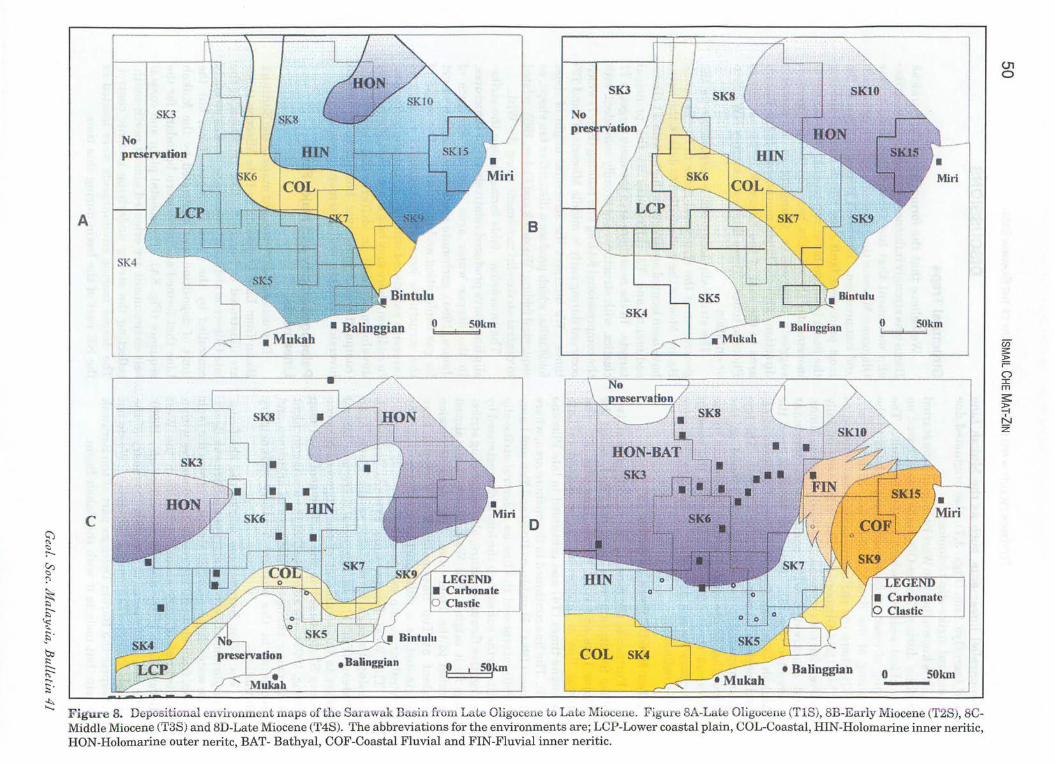
Figure 9. Tectonic maps ofthe Sarawak Basin from Late Oligocene to Late Miocene showing the major fault lineaments during the respective times. Figure 9A·Late Oligocene (TIS), 9B-Early Miocene (T2S), 9C-Middle Miocene (T3S) and 9D·Late Miocene (T4S).
-; m () -l 0 Z 0 (j)
m < 0 r C -l 6 z ;p z 0 (j) m 0 ~ m Z -l ;p -l 6 z :c U5 -l 0 ::0 -< 0 -n -l :c m en ;p ::0 ;p ~ ;p ;:0;;
CD ;p (j)
z
01 .......
52 ISMAil CHE MAT-ZIN
The pattern ofN-S depositional environments is repeated during the early Miocene times when sequence T2 was deposited (Fig. BB). However the coastal plain, coastal and inner neritic belts were thinner at this time, with a broader area of outer neritic (deep) marine environment to the NE, inferred from seismic reflection characteristics. The orientation of the coastlines during the T1 and T2 times seem to be coincident with the location of the West Balingian Line and Mukah Line during the Late Oligocene-Early Miocene times (Figs. 9A and 9B). However, the orientation of the coastline changed during the middle Miocene (sequence T3). The NW-SE and N-S orientation is no longer evident from the pattern of sediment distribution and depositional environments. The dominant orientation became E-W (Fig. BC), almost parallel to the present day coast line. This is probably the result of cessation of basement fault movements and the major basement subsidence in the Northwestern Sub-basin.
The major subsidence in the North-western Subbasin could be resulted by the releasing oversteps between the West Balingian Line and the Igan-Oya Line (Fig. 9C) which could also involve counterclockwise rotation of the block which is believed to take place during the Middle Miocene times (T3S). As a consequence, the majority of the basin was in the inner neritic environment, favouring the
. production of carbonate reefs. Carbonate production continued until the late Miocene times after which the Baram delta started to prograde into the area and shut down carbonate production in the area influenced by clastic progradation.
The initial location of the Baram Delta which was formed during the Late Miocene times is coincident with th~ location of the Tinjar Line. Therefore it is believed that the initial progradation the delta is most likely caused by strike-slip movement along the Tinjar Line (Fig; 9D). The delta was then shifted farther to the east during Oligocene when the West Baram Line started to be active during Pliocene.
CONCLUSIONS
1. The formation of the Sarawak Basin is due to strike-slip tectonism. The orientation of the faults and their subsidiary structures, including pull-apart basins, strongly suggests right lateral (dextral) displacement. The age of fault movement, based on analysis of the sequence stratigraphy, is primarily late Oligocene to Middle Miocene along the West Balingian Line, but later to the east.
2. The sedimentary succession can be divided into
seven s~quences, based on regionally correlatable unconformities and their relative conformities. The distribution of sediment is strongly controlled by the strike-slip tectonics until Middle Miocene times when basementcontrolled subsidence of the entire basin took place, with a hinge-line located close to the present coastline.
3. The structural traps and the formation of highs where carbonate were preferentially generated, were the mainly the product of the strike-slip deformation.
4. The creation of palaeogeographic maps can be used in the prediction of source rock and reservoir intervals, and the distribution of depositional environments can be linked to the relative timing and orientation of the principal fault lineaments.
ACKNOWLEDGEMENTS We wish to thank PETRONAS for the
permission to present and to publish this paper.
REFERENCES AGOSTINELll, E., TAJUDDIN, M.R., ANroNJELu, E. AND ARIs, M.M.,
1990. Miocene-Pliocene paleogeographic evolution of a tract of Sarawak offshore between Bintulu and Miri. Bull. Geol. Soc. o/Malaysia, 27,117-136.
BRIAIS, A., PATRAIT, P. AND TAPPONNIER, P., 1993. Updated interpretation of magnetic anomalies and sea floor spreading stages in the South China Sea. Journal 0/ Geophysical Research, 98(B4), 629~28.
HAGEMAN, H., 1987. Palaeobathymetrical changes in NW Sarawak during Oligocene to Pliocene. Bull. Geol. Soc. 0/ Malaysia, 21, 91-102.
RING, Y.E., 1992. Geological map ofSarawak, second edition. Director General of Geological Survey of Malaysia.
Ho, K.F., 1978. Stratigraphic framework for oil exploration in Sarawak. Bull. Geol. Soc. of Malaysia, 10, 1-14.
HUTCHISON, C.S., 1988. Stratigraphic-tectonic mode1 for eastern Borneo. Bull. Geol. Soc. o/Malaysia, 22, 135-151.
JAMES, D.M.D., 1984. The geology and hydrocarbon resources of Negara Brunei Darulsalam. Brunei Museum and Brunei Shell Petroleum Company.
JAMIL, A.S.A., ANuAR, M.A. AND ERIK SEAH, P.K., 1991. Geochemistry of selected crude oils from Sabah and Sarawak. Bull. Geol. Soc. o/Malaysia, 28, 123-150.
KANG, C.S. AND KADm, M.K.A., 1990. The use of SAR imegezy for hydrocarbon exploration in Sarawak. Bull. Geol. Soc. Malaysia, 27, 161-182. .
LEVESQUE, R. AND Oor, C.M., 1989. Block SK-5: Structural framework based on Regional seismic interpretation, Sarawak Shell Berhad (SSB), (Unpublished)
TAN, D.N.K AND J.M. LAMY, 1990. Tectonic evolution of the NW Sabah continental margin since the Late Eocene. Bull. Geol. Soc. o/Malaysia, 27, 241-260.
WOODCOCK, N.H. AND FISHER, M., 1985. Strike-slip duplexes. Journal of Structural Geology, 8(7), 725-735.
Manuscript received 4 June 1997 Geol. Soc. MalaYdia, Bulletin 41