gravity investigation of the bukit bunuh ... - ukm.edu.my abdul rahim.pdfshowed that the bukit bunuh...
TRANSCRIPT
Sains Malaysiana 41(12)(2012): 1629–1634
Gravity Investigation of the Bukit Bunuh Impact Crater at Lenggong, Perak, Malaysia
(Kajian Graviti Kawah Impak Bukit Bunuh di Lenggong, Perak, Malaysia)
ABduL RAhIM SAMSudIn*, ABduL RAhIM hARun, Mohd. hARIRI ARIfIn, uMAR hAMzAh, MoKhtAR SAIdIn & M Shyeh SAhIBuL KARAMAh
ABStRACt
An archeological study, conducted by the Archaeological Global Research Centre, Universiti Sains Malaysia shows the evidence of shock metamorphisms (suevite breccia) and crater morphology at Bukit Bunuh in Lenggong area of north Perak, Malaysia. A regional gravity survey focusing at Bukit Bunuh and its surrounding area was conducted to justify the occurrence and to determine the diameter and subsurface geological structure of the Bukit Bunuh impact crater. The gravity survey, using a Scintrex CG5 gravity meter, comprises 476 gravity stations with a 500 m spacing covering an area of approximately 160 km2. The elevation of the gravity stations were obtained by using a pair of Wellace and Tiernan altimeters. The gravity data were corrected for drift, free air, bouguer, latitude and terrain in order to produce a corrected gravity data of the study area. The data were processed and analysed using Oasis Montaj (Geosoft software) to produce bouguer, residual, Total Horizontal Derivative (THD) residual, regional and Total Horizontal Derivative (THD) regional anomaly maps for qualitative and quantitative interpretations. The bouguer gravity map shows relatively low negative anomaly with nearly circular shaped contour around the Bukit Bunuh area. This anomaly was interpreted as the remnant of meteorite impact structure with rounded shaped crater in the study area. The bouguer anomaly map showed that the Bukit Bunuh impact crater has a diameter of approximately 2.5 km. The impact structure was successfully modeled as a complex impact crater with maximum depth of about 300 m. The bouguer anomaly map also shows the possible occurences of at least two more impact craters located in the northeast and southeast areas of the Bukit Bunuh crater and these structures need further investigation for confirmation.
Keywords: Archaeology; complex crater; gravity anomaly; meteorite impact structures
ABStRAK
Kajian arkeologi yang telah dijalankan oleh Pusat Penyelidikan Arkeologi Global, Universiti Sains Malaysia menunjukkan bukti kewujudan metamorfisme kejutan (suevite breksia) dan morfologi kawah di Bukit Bunuh, Lenggong, Utara Perak, Malaysia. Kajian graviti rantau dengan penumpuan di Bukit Bunuh dan kawasan sekitarnya telah dilakukan untuk mengesahkan pembentukan dan menentukan diameter serta struktur geologi permukaan bawah kawasan hentaman di Bukit Bunuh. Tinjauan graviti menggunakan meter graviti Scintrex CG-5, mengandungi 476 stesen graviti dengan jarak antara stesen 500 m meliputi kawasan seluas 160 km2. Ketinggian stesen graviti telah ditentukan menggunakan sepasang altimeter Wellace & Tiernan. Data graviti telah dilakukan pembetulan hanyutan, udara bebas, bougeur, latitude dan terain untuk menghasilkan data graviti yang sebenar bagi kawasan tersebut. Data kemudiannya diproses dan dianalisis menggunakan Oasis Montaj (Perisian Geosoft) untuk mendapatkan peta anomali bouguer, baki, rantau, terbitan mendatar jumlah (THD) baki dan terbitan mendatar jumlah (THD) rantau untuk pentafsiran kuantitatif dan kualitatif. Peta graviti bouguer menunjukkan anomali relatif yang rendah dan negatif dengan kontur membulat di sekitar Bukit Bunuh. Anomali ini ditafsirkan sebagai sisa struktur hentaman meteorit dengan diameter 2.5 km. Struktur hentaman telah berjaya dimodelkan sebagai kawah kompleks dengan kedalaman maksimum 300 m. Peta anomali bouguer juga menunjukkan kemungkinan pembentukan paling kurang dua atau lebih kawah hentaman di bahagian timur laut dan tenggara kawah Bukit Bunuh dan struktur ini memerlukan kajian lanjut untuk pengesahan.
Kata kunci: Anomali graviti; arkeologi; kawah kompleks; struktur hentaman meteorit
IntRoduCtIon
Meteorite impact structures are found on all planetary bodies in the solar system with a solid surface. on the Moon, Mercury and much of Mars, impact craters are the dominant landform. on earth, 182 impact sites have been recognized with several more new craters being discovered
each year (ferrière 2011). Geological arguments for an impact origin have been based on geomorphology, rock textures, mineral deformation and stratigraphic relations (Carpenter & Carlson 1992; hamm & olsen 1992; nick 1994). Anizan Isahak (1990) reported the presence of shock-induced features such as planar lamellar features,
1630
cleavages and kink bands in quartz in the granite underlying the Kuantan basalt is caused by a meteoritic impact. Abdul Rahim Samsudin et al. (2002a, 2002b) used gravity survey to model a meteorite impact crater found in Langkawi, Malaysia. the detailed geological description and a subsequent study on lineaments based on aerial photograph of the area, clearly indicates the semi-circular rim structure of the impact crater (tjia 2001). the idea of possible occurrence of a meteorite impact crater at Bukit Bunuh, Lenggong, Perak area was proposed by researchers from the Global Archeological Research Centre of university Science Malaysia (Mokhtar 2004). This findings was based on several field evidences which include the discovery of shock metamorphic rocks (suevite breccias), shatter cones, crater morphology (Bukit Bunuh rings) and geophysical anomaly (Mohd n. nawawi et al. 2004). In this context, gravity measurements proved to be a valuable tool in the investigation of impact structures. the gravity potential theory tells us that from the integration over a gravity negative anomaly the total mass deficit can be calculated regardless of the specific density distribution. As in impact structures the mass deficit is
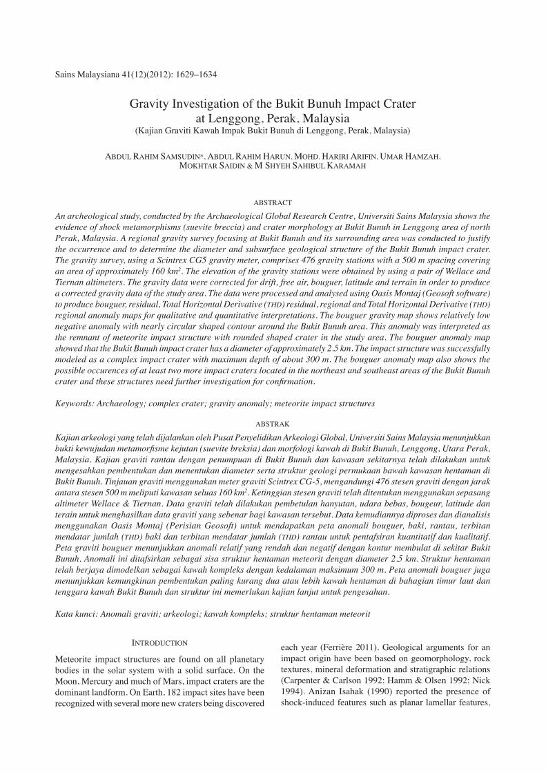
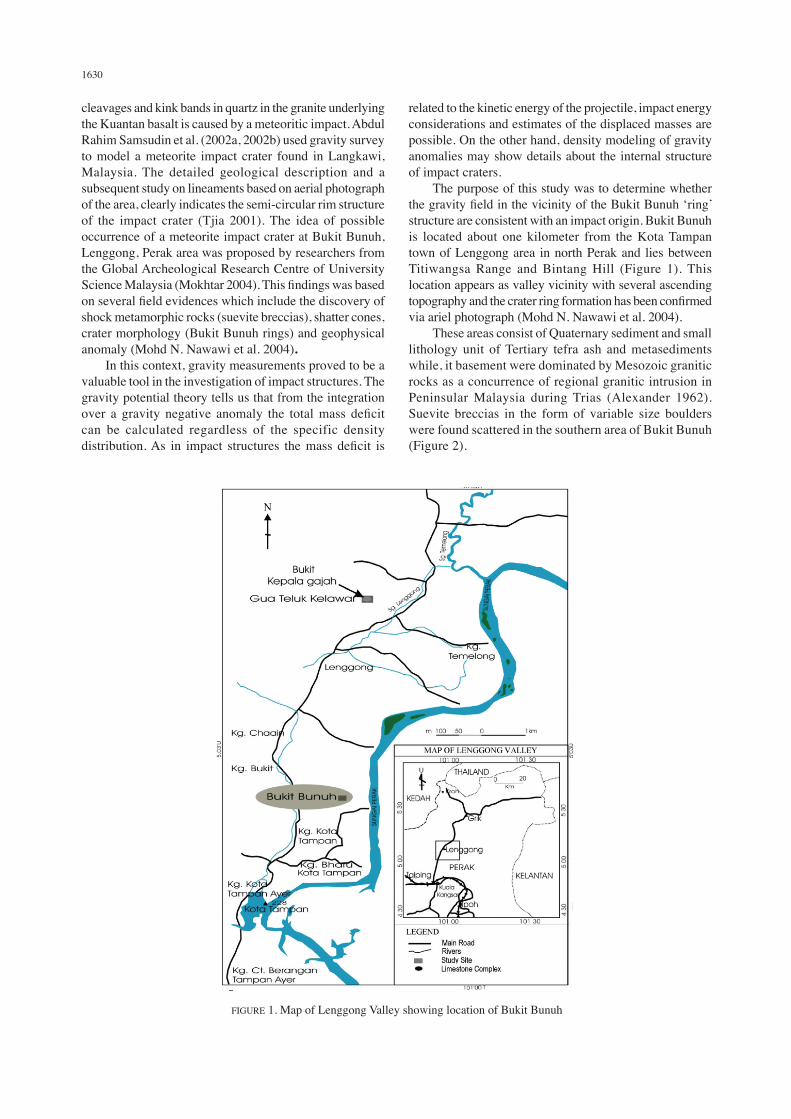
related to the kinetic energy of the projectile, impact energy considerations and estimates of the displaced masses are possible. on the other hand, density modeling of gravity anomalies may show details about the internal structure of impact craters. the purpose of this study was to determine whether the gravity field in the vicinity of the Bukit Bunuh ‘ring’ structure are consistent with an impact origin. Bukit Bunuh is located about one kilometer from the Kota tampan town of Lenggong area in north Perak and lies between titiwangsa Range and Bintang hill (figure 1). this location appears as valley vicinity with several ascending topography and the crater ring formation has been confirmed via ariel photograph (Mohd n. nawawi et al. 2004). these areas consist of Quaternary sediment and small lithology unit of tertiary tefra ash and metasediments while, it basement were dominated by Mesozoic granitic rocks as a concurrence of regional granitic intrusion in Peninsular Malaysia during trias (Alexander 1962). Suevite breccias in the form of variable size boulders were found scattered in the southern area of Bukit Bunuh (figure 2).
fIGuRe 1. Map of Lenggong Valley showing location of Bukit Bunuh
1631
MAteRIALS And MethodS
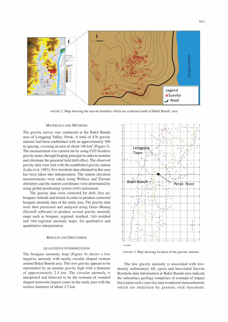
the gravity survey was conducted at the Bukit Bunuh area of Lenggong Valley, Perak. A total of 476 gravity stations had been established with an approximately 500 m spacing, covering an area of about 160 km2 (figure 3). the measurement was carried out by using CG5 Scintrex gravity meter, through looping principal in order to monitor and eliminate the potential field drift effect. The observed gravity data were tied with the established gravity station (Loke et al. 1983). few borehole data obtained in this area has been taken into interpretation. the station elevation measurements were taken using Wellace and tiernan altimeters and the station coordinates were determined by using global positioning system (GPS) instrument. the gravity data were corrected for drift, free air, bouguer, latitude and terrain in order to produce corrected bouguer anomaly data of the study area. the gravity data were then processed and analysed using oasis Montaj (Geosoft software) to produce several gravity anomaly maps such as bouguer, regional, residual, thd residual and thd regional anomaly maps, for qualitative and quantitative interpretation.
ReSuLtS And dISCuSSIon
QuALItAtIVe InteRPRetAtIon
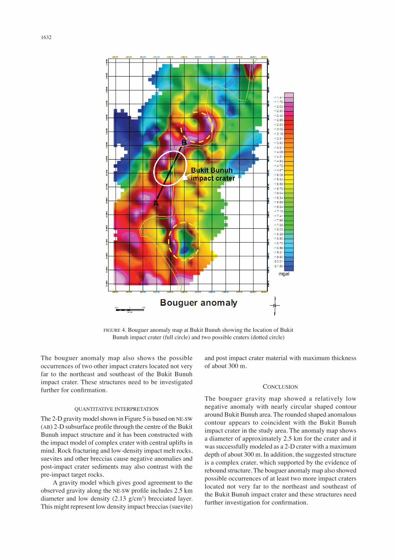
the bouguer anomaly map (figure 4) shows a low negative anomaly with nearly circular shaped contour around Bukit Bunuh area. this low gravity appears to be surrounded by an annular gravity high with a diameter of approximately 2.5 km. the circular anomaly is interpreted and believed to be the remnant of rounded shaped meteorite impact crater in the study area with the surface diameter of about 2.5 km.
the low gravity anomaly is associated with low-density sedimentary fill, ejecta and brecciated Suevite Borehole data information at Bukit Bunuh area indicate the subsurface geology comprises of remnant of impact brecciated rocks (suevite) and weathered metasediments which are underlain by granitic rock basement.
fIGuRe 2. Map showing the suevite boulders which are scattered south of Bukit Bunuh area
fIGuRe 3. Map showing location of the gravity stations
1632
the bouguer anomaly map also shows the possible occurrences of two other impact craters located not very far to the northeast and southeast of the Bukit Bunuh impact crater. these structures need to be investigated further for confirmation.
QuAntItAtIVe InteRPRetAtIon
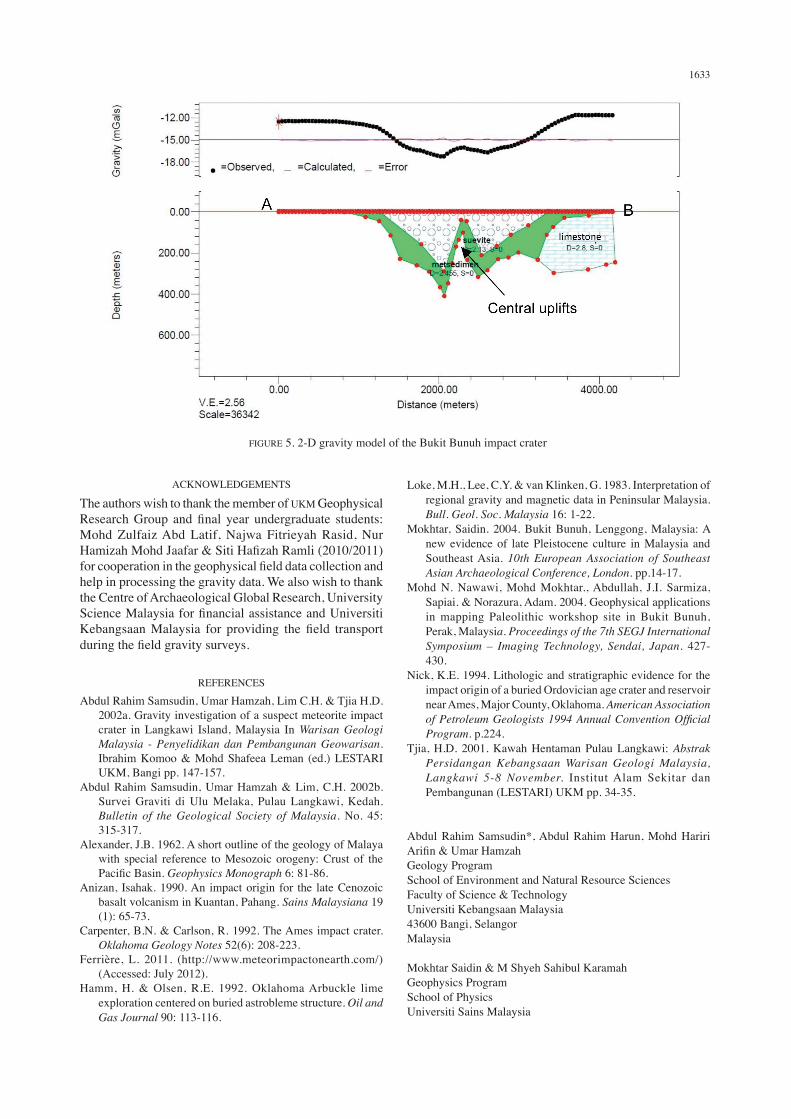
the 2-d gravity model shown in figure 5 is based on ne-SW (AB) 2-D subsurface profile through the centre of the Bukit Bunuh impact structure and it has been constructed with the impact model of complex crater with central uplifts in mind. Rock fracturing and low-density impact melt rocks, suevites and other breccias cause negative anomalies and post-impact crater sediments may also contrast with the pre-impact target rocks. A gravity model which gives good agreement to the observed gravity along the ne-SW profile includes 2.5 km diameter and low density (2.13 g/cm3) brecciated layer. this might represent low density impact breccias (suevite)
and post impact crater material with maximum thickness of about 300 m.
ConCLuSIon
the bouguer gravity map showed a relatively low negative anomaly with nearly circular shaped contour around Bukit Bunuh area. the rounded shaped anomalous contour appears to coincident with the Bukit Bunuh impact crater in the study area. the anomaly map shows a diameter of approximately 2.5 km for the crater and it was successfully modeled as a 2-d crater with a maximum depth of about 300 m. In addition, the suggested structure is a complex crater, which supported by the evidence of rebound structure. the bouguer anomaly map also showed possible occurrences of at least two more impact craters located not very far to the northeast and southeast of the Bukit Bunuh impact crater and these structures need further investigation for confirmation.
fIGuRe 4. Bouguer anomaly map at Bukit Bunuh showing the location of Bukit Bunuh impact crater (full circle) and two possible craters (dotted circle)
1633
ACKnoWLedGeMentS
the authors wish to thank the member of uKM Geophysical Research Group and final year undergraduate students: Mohd zulfaiz Abd Latif, najwa fitrieyah Rasid, nur Hamizah Mohd Jaafar & Siti Hafizah Ramli (2010/2011) for cooperation in the geophysical field data collection and help in processing the gravity data. We also wish to thank the Centre of Archaeological Global Research, university Science Malaysia for financial assistance and Universiti Kebangsaan Malaysia for providing the field transport during the field gravity surveys.
RefeRenCeS
Abdul Rahim Samsudin, umar hamzah, Lim C.h. & tjia h.d. 2002a. Gravity investigation of a suspect meteorite impact crater in Langkawi Island, Malaysia In Warisan Geologi Malaysia - Penyelidikan dan Pembangunan Geowarisan. Ibrahim Komoo & Mohd Shafeea Leman (ed.) LeStARI uKM, Bangi pp. 147-157.
Abdul Rahim Samsudin, umar hamzah & Lim, C.h. 2002b. Survei Graviti di ulu Melaka, Pulau Langkawi, Kedah. Bulletin of the Geological Society of Malaysia. no. 45: 315-317.
Alexander, J.B. 1962. A short outline of the geology of Malaya with special reference to Mesozoic orogeny: Crust of the Pacific Basin. Geophysics Monograph 6: 81-86.
Anizan, Isahak. 1990. An impact origin for the late Cenozoic basalt volcanism in Kuantan, Pahang. Sains Malaysiana 19 (1): 65-73.
Carpenter, B.n. & Carlson, R. 1992. the Ames impact crater. Oklahoma Geology Notes 52(6): 208-223.
ferrière, L. 2011. (http://www.meteorimpactonearth.com/) (Accessed: July 2012).
hamm, h. & olsen, R.e. 1992. oklahoma Arbuckle lime exploration centered on buried astrobleme structure. Oil and Gas Journal 90: 113-116.
Loke, M.h., Lee, C.y. & van Klinken, G. 1983. Interpretation of regional gravity and magnetic data in Peninsular Malaysia. Bull. Geol. Soc. Malaysia 16: 1-22.
Mokhtar, Saidin. 2004. Bukit Bunuh, Lenggong, Malaysia: A new evidence of late Pleistocene culture in Malaysia and Southeast Asia. 10th European Association of Southeast Asian Archaeological Conference, London. pp.14-17.
Mohd n. nawawi, Mohd Mokhtar., Abdullah, J.I. Sarmiza, Sapiai. & norazura, Adam. 2004. Geophysical applications in mapping Paleolithic workshop site in Bukit Bunuh, Perak, Malaysia. Proceedings of the 7th SEGJ International Symposium – Imaging Technology, Sendai, Japan. 427-430.
nick, K.e. 1994. Lithologic and stratigraphic evidence for the impact origin of a buried ordovician age crater and reservoir near Ames, Major County, oklahoma. American Association of Petroleum Geologists 1994 Annual Convention Official Program. p.224.
tjia, h.d. 2001. Kawah hentaman Pulau Langkawi: Abstrak Persidangan Kebangsaan Warisan Geologi Malaysia, Langkawi 5-8 November. Institut Alam Sekitar dan Pembangunan (LeStARI) uKM pp. 34-35.
Abdul Rahim Samsudin*, Abdul Rahim harun, Mohd hariri Arifin & Umar HamzahGeology ProgramSchool of environment and natural Resource Sciencesfaculty of Science & technologyuniversiti Kebangsaan Malaysia43600 Bangi, SelangorMalaysia
Mokhtar Saidin & M Shyeh Sahibul KaramahGeophysics Program School of Physicsuniversiti Sains Malaysia
fIGuRe 5. 2-d gravity model of the Bukit Bunuh impact crater

1634
11800 uSM, Penang Malaysia
*Corresponding author; email: [email protected]
Received: 9 March 2012Accepted: 6 August 2012