source of the batu pahat magnetic anomaly · antara 50 hingga 100 meter manakala badan kedua...
TRANSCRIPT
Geological Society of Malaysia Annual Geological Conference 2001 June 2-3 2001 , Pangkor Island, Perak Darul Redzuan, Malaysia
Source of the Batu Pahat magnetic anomaly
SAMSUDIN BIN HJ TAIB, KHAIRUN NIZA BAHARALDIN AND AZMAN ABDUL GHANI
Department of Geology, University of Malaya 50603 Kuala Lumpur
Abstract: An almost circular magnetic anomaly north of Batu Pahat town is made up of a pair of magnetic high and magnetic low. It is a typical magnetic anomaly at this magnetic latitude with magnetization in the earths field direction where the magnetic high i situated to the north and the magnetic low to its south. The magnetic anomaly has been generally associated to the Batu Pahat granite which outcrops east, west and south of the town. However, the location of the anomaly only at the northern tip of the granite mass uggest that it is not the source. The geological study indicates that gabbro is present within this magnetic anomaly area. Modelling of the anomaly indicates that two source bodies produce the anomaly. The first is situated where the gabbro is located and the second body is located slightly to the north. This locat ion was forma ll y a bauxite mine. The first has its top at about 50 to 100 meters depth while the second body has its base at less than I 00 meters. The deeper body is presumably associated with the gabbro while the second body ~s probably of sedimentary origin. The Batu Pahat residual magnetic anomaly map suggest that the short wavelength anomalies present are associated with shallow fracture system having orientat ion simi lar to that of the existing faults trend in the granite.
Abstrak: Satu anomali magnet berbentuk hampir membulat di utara bandar Batu Pahat adalah terdiri daripada sepasang anomaly magnet tinggi dan anomali magnet rendah . Kedudukan anomali magnet tinggi adalah di sebelah utara dan anoma li magnet rendah di sebelah selatan. Keadaan ini adalah biasa bagi anomali magnet yang terdapat di latitud magnet di sini dengan kemagnetan dalam arah medan magnet bumi. Anomali magnet ini biasanya dikaitkan dengan granit Batu Pahat yang tersingkap di timur, barat dan selatan bandar. Tetapi, kedudukan anomaly yang hanya terdapat di hujung utara jasad granit tersebut menunjukkan yang granite bukan punca medan magnet tersebut. Kajian geologi menunjukkan terdapat gabro dilingkungan anomali magnet ini . Pemodelan menunjukan terdapat dua jasad punca bagi anomaly ini. Punca pertama terdiri dari badan yang terletak di mana gabro berada dan yang punca kedua terletak ke utara sedikit. Lokasi badan kedua ini adalah bekas lombong bauksit. Bahag ian atas jasad pertama ada lah pada kedalaman anggaran antara 50 hingga 100 meter manakala badan kedua mempunyi dasar pada kedalarnan anggaran 100 meter. Badan yang pertama mungkin berhubung rapat dengan gabro manaka la yang kedua mungkin berpunca dari sedimen. Anomali magnet baki menunjukkan bahawa komponen anoma li gelombang pendek boleh di hubungkan dengan sistem retakan cetek yang mempunyi orientasi sama dengan tren sesar yang terdapat pada granit.
INTRODUCTION
A prominent magnetic anomaly can be observed at the northern part of the Batu Pahat town. The magnetic anomaly consist of a pair of a magnetic high and a magnetic low. The magnetic high is at the northern side while the magnetic low on the south. This is typical of a magnetic anomaly pair having magnetization in the direction of earths magnetic field located south of the magnetic equator. The anomaly has normally been associated with the Batu Pahat granite body which outcrops around the Batu Pahat town, to its south, east and west. The presence of this magnetic anomaly only on the northern part of the Batu Pahat granite suggests that the source is probably not the granite body directly ne1ther it is the only source. Furthermore, the gran ite generalLy has low susceptibility thus low magnetization. With this scenario in mind a study was conducted to determine the source of this Batu Pahat magnetic anomaly.
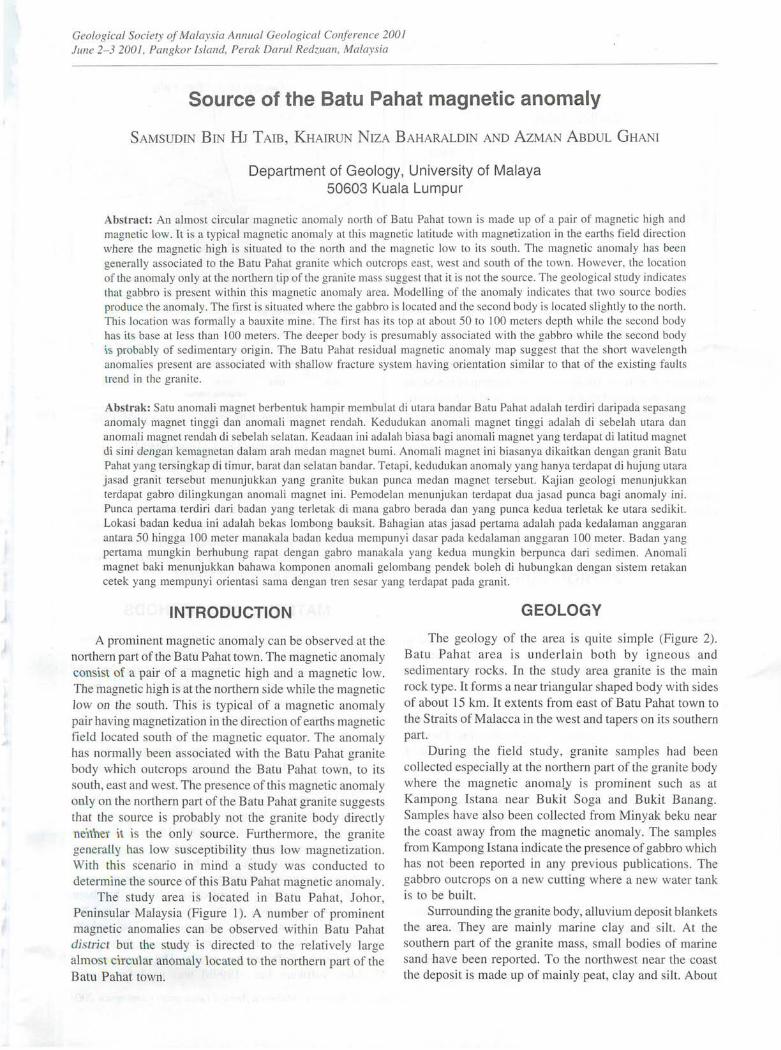
The study area is located in Batu Pahat, Johor, Penin ular Malaysia (Figure 1). A number of prominent magnetic anomalies can be observed within Batu Pahat district but the study is directed to the relatively large almo t circular anomaly located to the northern part of the Batu Pahat town.
GEOLOGY
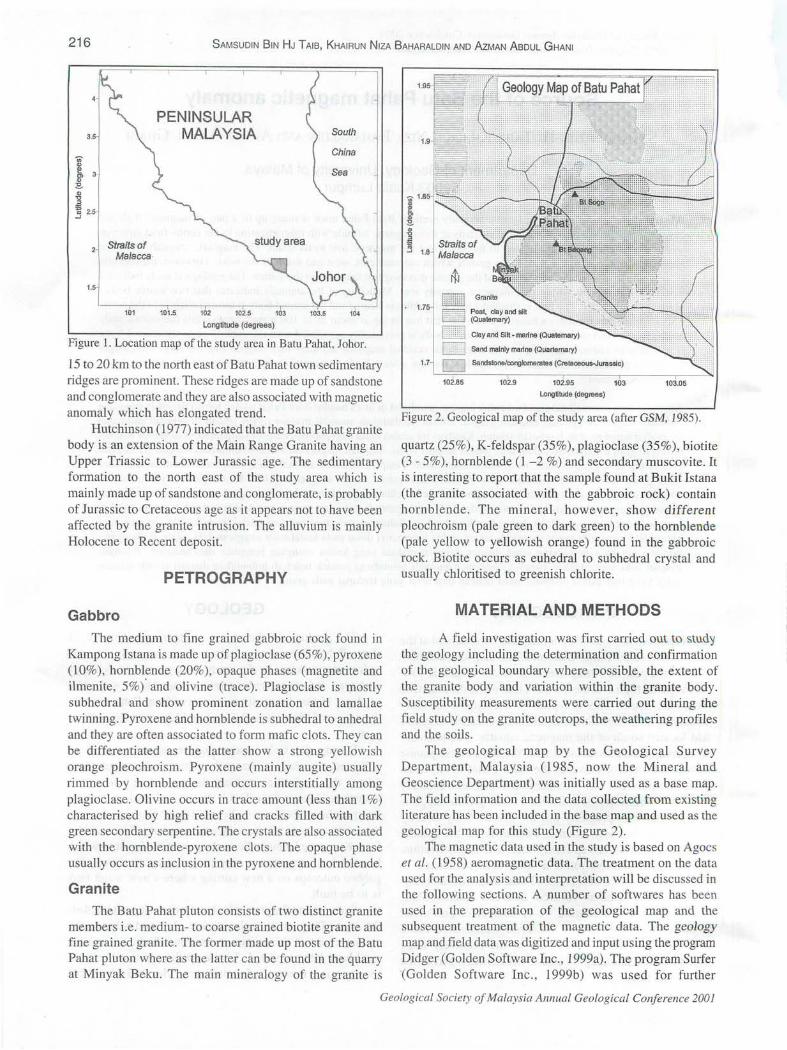
The geology of the area is quite simple (Figure 2). Batu Pahat area is underlain both by igneou s and sedimentary rocks. In the study area granite is the main rock type. It forms a near triangular shaped body with sides of about 15 km. It extents from east of Batu Pahat town to the Straits of Malacca in the west and tapers on its outhern part.
During the field study, granite samples had been collected especially at the northern part of the granite body where the magnetic anomal,.y is prominent such as at Kampong Istana near Bukit Soga and Bukit Banang. Samples have also been collected from Minyak beku near the coast away from the magnetic anomaly. The samples from Kampong Istana indicate the presence of gabbro which has not been reported in any previous publications. The gabbro outcrops on a new cutting where a new water tank is to be built.
Surrounding the granite body, alluvium deposit blankets the area. They are mainly marine clay and silt. At the southern part of the granite mass, small bodies of marine sand have been reported. To the northwest near the coast the deposit is made up of mainly peat, clay and si lt. About
216 SAMSUDIN BIN HJ T AlB, KHAIRUN NIZA BAHARALDIN AND AzMAN ABDUL GHANI
3.5
., "' ll, 3
" ~ "' " .3 ~ 2.5
1.5
Straits of Ma/acca
101
PENINSULAR MALAYSIA
101.5 102 102.5 103
Longtitude (degrees)
103.5 104
Figure 1. Location map of the study area in Batu Pahat, Johor.
15 to 20 km to the north east ofBatu Pahat town sedimentary ridges are prominent. These ridges are made up of sandstone and conglomerate and they are also associated with magnetic anomaly which has elongated trend.
Hutchinson (1977) indicated that the Batu Pahat granite body is an extension of the Main Range Granite having an Upper Triassic to Lower Jurassic age. The sedimentary formation to the north east of the study area which is mainly made up of sandstone and conglomerate, is probably of Jurassic to Cretaceous age as it appears not to have been affected by the granite intrusion. The alluvium is mainly Holocene to Recent deposit.
PETROGRAPHY
Gabbro
The medium to fine grained gabbroic rock found in Kampong Istana is made up of plagioclase (65% ), pyroxene (10%), hornblende (20%), opaque phases (magnetite and ilmenite, 5%). and olivine (trace). Plagioclase is mostly subhedral and show prominent zonation and lamallae twinning. Pyroxene and hornblende is subhedral to anhedral and they are often associated to form mafic clots. They can be differentiated as the latter show a strong yellowish orange pleochroism. Pyroxene (mainly augite) usually rimmed by hornblende and occurs interstitially among plagioclase. Olivine occurs in trace amount (less than 1 %) characterised by high relief and cracks filled with dark green secondary serpentine. The crystals are also associated with the hornblende-pyroxene clots. The opaque phase usually occurs as inclusion in the pyroxene and hornblende.
Granite
The Batu Pahat pluton consists of two distinct granite members i.e. medium- to coarse grained biotite granite and fine grained granite. The former made up most of the Batu Pahat pluton where as the latter can be found in the quarTy at Minyak Beku. The main mineralogy of the granite is
Longtitude (degrees)
Figure 2. Geological map of the study area (after GSM, 1985).
quartz (25%), K-feldspar· (35%), plagioclase (35%), biotite (3- 5%), hornblende (1-2 %) and secondary muscovite. It is interesting to report that the sample found at Bukit Istana (the granite associated with the gabbroic rock) contain hornblende. The mineral, however, show different pleochroism (pale green to dark green) to the hornblende (pale yellow to yellowish orange) found in the gabbroic rock. Biotite occurs as euhedral to subhedral crystal and usually chloritised to greenish chlorite.
MATERIAL AND METHODS
A field investigation was first carried out to stud':) the geology including the determination and confirmation of the geological boundary where possible, the extent of the granite body and variation within the granite body. Susceptibility measurements were carried out during the field study on the granite outcrops, the weathering profiles and the soils.
The geological map by the Geological Survey Department, Malaysia (1985, now the Mineral and Geoscience Department) was initially used as a base map. The field information and the data collected from existing literature has been included in the base map and used as the geological map for this study (Figure 2).
The magnetic data used in the study is based on Agocs et al. (1958) aeromagnetic data. The treatment on the data used for the analysis and interpretation will be discussed in the following sections. A number of softwares has been used in the preparation of the geological map and the subsequent treatment of the magnetic data. The geology map and field data was digitized and input using the program Didger (Golden Software Inc., 1999a). The program Surfer (Golden Software Inc., 1999b) was used for further
Geological Society of Malaysia Annual Geological Conference 2001
SOURCE OF THE BATU PAHAT MAGNETIC ANOMALY 217
treatment and display of both the geology and the magnetic map. The magnetic data has been gridded and contoured using Surfer. Beside the visual presentation of data by Surfer it allows superposition of the magnetic map on to the geology map. The program Surfer has other facilities such as enabling the extraction of data along specific profiles and for a specific area, image processing such as producing shaded relief maps and gridding random data at different intervals. Many of the facilities has been used to produce the maps used in this study.
The modelling has been carried out using the program MAG (Bott, 1988). This routine allows a two dimensional modelling to be carried out.
MAGNETIC SUSCEPTIBILITY
Magnetic susceptibility measurements on the gabbro give a relatively high value. Measurement on the granite outcrops mostly gives no or low susceptibility value. Instances of high susceptibility values in granite body occur within small veins. Generally this high value can be trace for half to a meter long. Measurements on the soils and weathering profiles generally produce low susceptibility values.
DATA TREATMENT
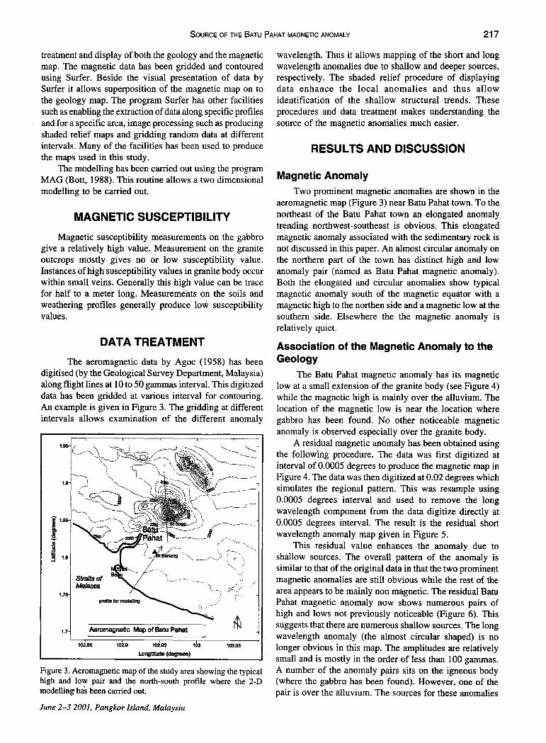
The aeromagnetic data by Agoc (1958) has been digitised (by the Geological Survey Department, Malaysia) along flight lines at 10 to 50 gammas interval. This digitized data has been gridded at various interval for contouring. An example is given in Figure 3. The gridding at different intervals allows examination of the different anomaly
I.Dng1llude (degrees)
:-;
,;;:-() C''
Figure 3. Aeromagnetic map of the study area showing the typical high and low pair and the north-south profile where the 2-D modelling has been carried out.
June 2-3 2001, Pangkor Island, Malaysia
wavelength. Thus it allows mapping of the short and long wavelength anomalies due to shallow and deeper sources, respectively. The shaded relief procedure of displaying data enhance the local anomalies and thus allow identification of the shallow structural trends. These procedures and data treatment makes understanding the source of the magnetic anomalies much easier.
RESULTS AND DISCUSSION
Magnetic Anomaly
Two prominent magnetic anomalies are shown in the aeromagnetic map (Figure 3) near Batu Pahat town. To the northeast of the Batu Pahat town an elongated anomaly trending northwest-southeast is obvious. This elongated magnetic anomaly associated with the sedimentary rock is not discussed in this paper. An almost circular anomaly on the northern part of the town has distinct high and low anomaly pair (named as Batu Pahat magnetic anomaly). Both the elongated and circular anomalies show typical magnetic anomaly south· of the magnetic equator with a magnetic high to the northen side and a magnetic low at the southern side. Elsewhere the the magnetic anomaly is relatively quiet.
Association of the Magnetic Anomaly to the Geology
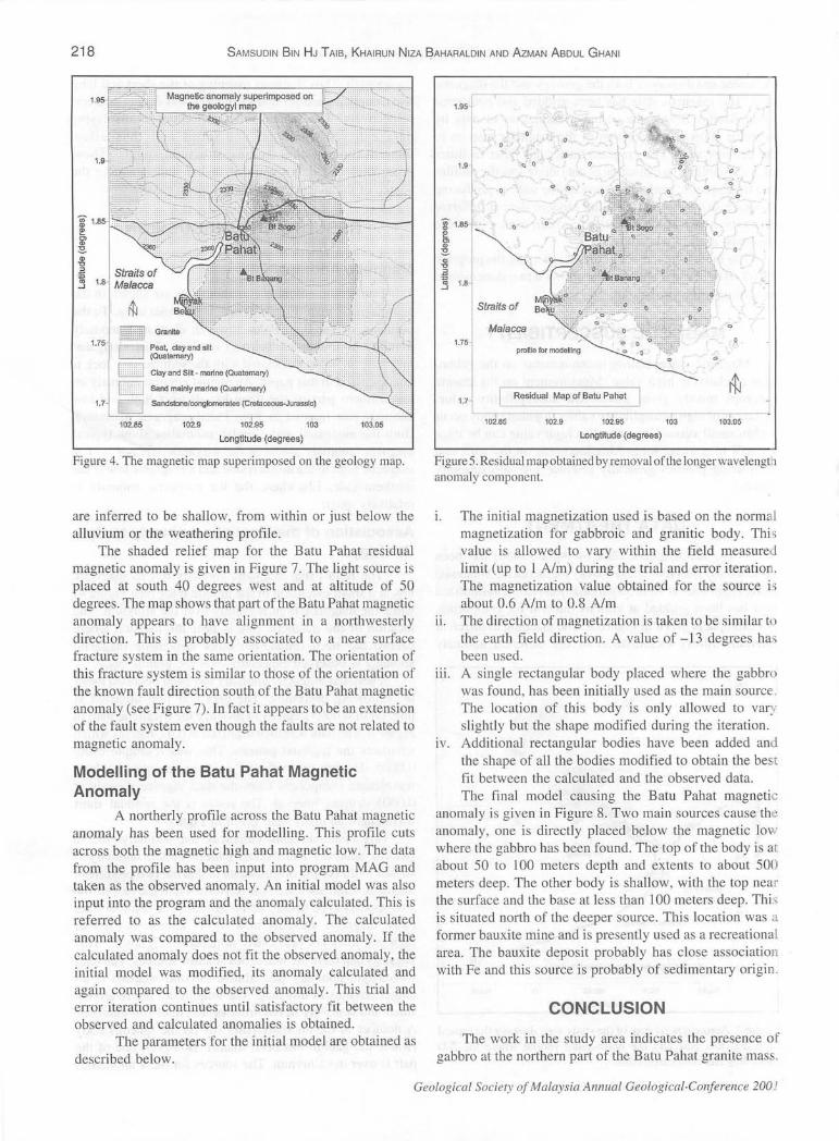
The Batu Pahat magnetic anomaly has its magnetic . low at a small extension of the granite body (see Figure 4)
while the magnetic high is mainly over the alluvium. The location of the magnetic low is near the location where gabbro has been found. No other noticeable magnetic anomaly is observed especially over the granite body.
A residual magnetic anomaly has been obtained using the following procedure. The data was first digitized at interval of 0.0005 degrees to produce the magnetic map in Figure 4. The data was then digitized at 0.02 degrees which simulates the regional pattern. This was resample using 0.0005 degrees interval and used to remove the long wavelength component from the data digitize directly at 0.0005 degrees interval. The result is the residual short wavelength anomaly map given in Figure 5.
This residual value enhances the anomaly due to shallow sources. The overall pattern of the anomaly is similar to that of the original data in that the two prominent magnetic anomalies are still obvious while the rest of the area appears to be mainly non magnetic. The residual Batu Pahat magnetic anomaly now shows numerous pairs of high and lows not previously noticeable (Figure 6). This suggests that there are numerous shallow sources. The long wavelength anomaly (the almost circular shaped) is no
· longer obvious in this map. The amplitudes are relatively small and is mostly in the order of less than 100 gammas. A number of the anomaly pairs sits on the igneous body (where the gabbro has been found). However, one of the pair is over the alluvium. The sources for these anomalies
218 SAMSUDIN BIN HJ T AlB, KHAIRUN NIZA f?AHARALDIN AND AZMAN ABDUL GHANI
Longtitude (degrees)
Figure 4. The magnetic map superimposed on the geology map.
are inferred to be shallow, from within or just below the alluvium or the weathering profile.
The shaded relief map for the Batu Pahat residual magnetic anomaly is given in Figure 7. The light source is placed at south 40 degrees west and at altitude of 50 degrees. The map shows that part of the Batu Pahat magnetic anomaly appears to have alignment in a northwesterly direction. This is probably associated to a near surface fracture system in the same orientation. The orientation of this fracture system is similar to those of the orientation of the known fault direction south of the Batu Pahat magnetic anomaly (see Figure 7). In fact it appears to be an extension of the fault system even though the faults are not related to magnetic anomaly.
Modelling of the Batu Pahat Magnetic Anomaly
A northerly profile across the Batu Pahat magnetic anomaly has been used for modelling. This profile cuts across both the magnetic high and magnetic low. The data from the profile has been input into program MAG and taken as the observed anomaly. An initial model was also input into the program and the anomaly calculated. This is referred to as the calculated anomaly. The calculated anomaly was compared to the observed anomaly. If the calculated anomaly does not fit the observed anomaly, the initial model was modified, its anomaly calculated and again compared to the observed anomaly. This trial and error iteration continues until satisfactory fit between the observed and calculated anomalies is obtained .
The parameters for the initial model are obtained as described below.
1.95
j' 1.8 e g> ~ Q) , "' ~ 1.8
1.7
· ~ 0
Straits of
Matacca
0
' -· 0 !.1:>
b o~ .. 0
'·
1.7 L_;'::=R=e=s=id=ua=l :;:M=a=p o=f=B=atu= Pa:;:h=a=t =---[ --.----.~--J~
102.85 102.9 102.95 103 103.05
Longtitude (degrees)
Figure 5. Residual map obtained by removal ofd1e longerwavelengL1 anomaly component.
1. The initial magnetization used is based on the norm a.! magnetization for gabbroic and granitic body. Thi s value is allowed to vary within the field measured limit (up to 1 A/m) during the trial and enor iteratio . The magnetization value obtained for the source is about 0.6 A/m to 0.8 Aim
ii. The direction of magnetization is taken to be similar to the earth field direction. A value of -13 degrees has been used.
HI. A single rectangular body placed where the gabbro was found, has been initially used as the main source . The location of this body is only allowed to var_; slightly but the shape modified during the iteration.
tv. Additional rectangular bodies have been added and the shape of all the bodies modified to obtain the best fit between the calculated and the observed data . The final model causing the Batu Pahat magnetic
anomaly is given in Figure 8. Two main sources cause the anomaly, one is directly placed below the magnetic lo ' where the gabbro has been found . The top of the body is at about 50 to l 00 meters depth and extents to about 500 meters deep. The other body is shallow, with the top neal' the smface and the base at less than 100 meters deep. Thi s is situated north of the deeper source. This location was a former bauxite mine and is presently used as a recreational area. The bauxite deposit probably has close association with Fe and this source is probably of edimentary origin .
CONCLUSION
The work in the study area indicates the presence of gabbro at the northern part of the Batu Pahat granite mass.
Geological Society of Malaysia Annual Geological-Conference 200 ' ·
SOURCE OF THE B ATU P AHAT MAGNETIC ANOMALY 219
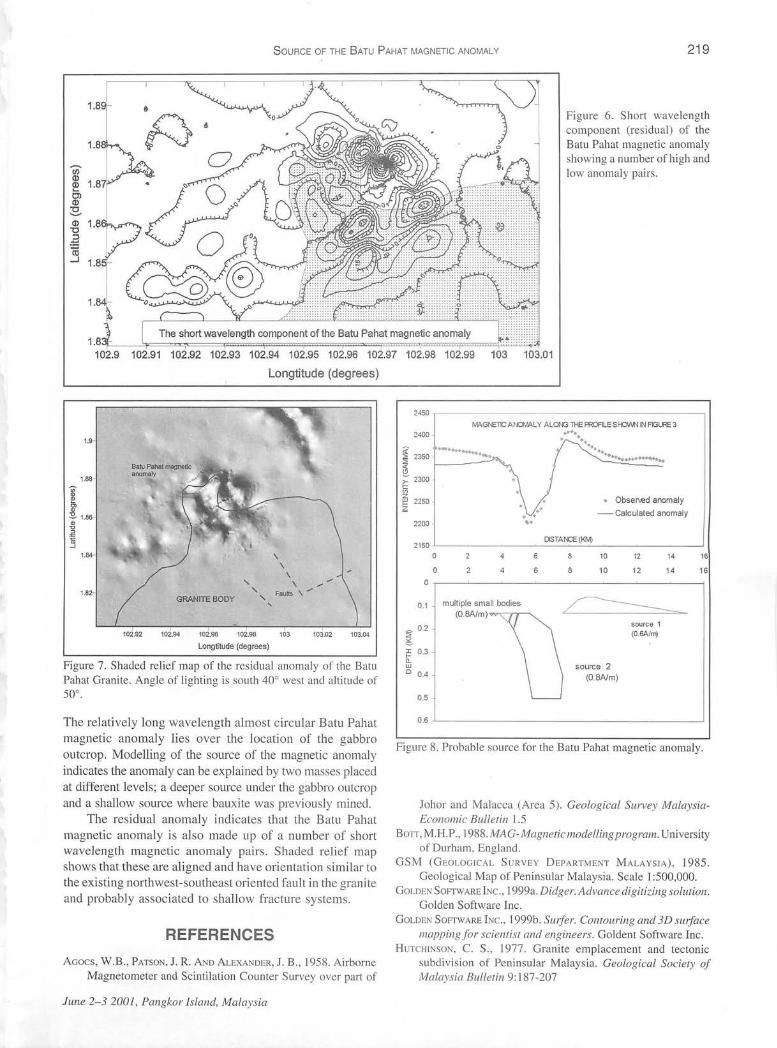
Figure 6. Short wavelength component (residual) of the Batu Pahat magnetic anomaly showing a number of high and low anomal y pairs.
102.91 102.92 102.93 102.94 102.95 102.96 102.97 102.98 102.99
Longtitude (degrees)
103 103.01
1.9-
1.88-
I g> ~ 1.86-
" "0
" ~ --'
1.84-
1.82
102.92
' GRANITE BODY
' '
' ' '
\ \
\ \
Faults \;
102.94 102.96 102.98 103
Longtitude (degrees)
' 103.02 103.04
Figure 7. Shaded relief map of the residual anomaly of the Batu Pahat Grani te. Angle of lighting is south 40° west and altitude of 50°.
The relatively long wavelength almost circul,ar Batu Pahat magnetic anomaly lies over the location of the gabbro outcrop. Modelling of the source of the magnetic anomaly indicates the anomaly can be explained by two masses placed at different levels; a deeper source under the gabbro outcrop and a shallow source where bauxite was previously mined.
The residual anomaly indicates that the Batu Pahat magnetic anomaly is also made up of a number of short wavelength magnetic anomaly pairs. Shaded relief map shows that these are aligned and have orientation similar to
the existing northwest-southeast oriented fault in the granite and probably associated to shallow fracture systems .
REFERENCES Aaocs, W.B. , PATSON, J. R. AND ALEXANDER, J. B., 1958. Airborne
Magnetometer and Scintilation Counter Survey over part of
June 2-3 2001 , Pangkor Island, Malaysia
2450 .,----------------------,
rv'AGi'EllC ANGMO.L Y ALONG 1HE PROALE SI-C\I\,I>J IN F'GU<E 3
2400 .... . · .. f 2350 ~ ~--
······• ................. ~ 2300
~ 2250 • Obser\ed anomaly
-Calculated anomaly 2200
llSTAt\0: (KM) 2150 .L_ _______ ~ __ _:__;_ _______ ____J
0 10 12 14 16
0 6 8 10 12 14 16
0.,--~--~-~----~--~-~-~
0.1 multiple small bodies (O.BA/m) .,......-r,.--,
~ 0.2
~
source 1 (0.6Afr1V
I 0.3 b: w 0 0.4
source 2 (O.BA/m)
0.5
0.6 J_ ___________________ ___J
Figure 8. Probable source for the Batu Pahat magnetic anomaly.
Johor and Malacca (Area 5). Geological Survey MalaysiaEconomic Bulletin 1.5
Borr,M.H.P., 1988.MAG-Magneticmodellingprogram. Uni versity of Durham, England.
GSM (GEOLOG ICAL SURVEY DEPARTMENT MALA YSIA), 1985. Geological Map of Peninsular Malaysia . Scale 1:500,000.
GoLDEN SOFTWARE INc., 1999a. Didger. Advance digitizing solution. Golden Software Inc .
GoLDEN SoFTWARE INc., 1999b. Stufer. Contouring and 3D su1jace mapping fo r scientist and engineers. Goldent Software Inc.
HuTCHI NSON, C. S. , 1977. Granite emplacement and tectonic subdivision of Peninsular Malaysia. Geological Society of Ma laysia Bulletin 9: 187-207