the townscape evolution of historic port settlement … · v u niersiti p utra m alasia 62 the...
TRANSCRIPT
Alam Cipta Vol 11 (2) December 2018UNIVERSITI PUTRA MALAYSIA 62
THE TOWNSCAPE EVOLUTION OF HISTORIC PORT SETTLEMENT OF GEORGE TOWN, PULAU PINANG, MALAYSIA
Zhao Long1*, Zulkifli Hanafi1 and Wong Hong Wei1
1Department of Architecture, Faculty of Architecture and Built Environment,Infrastructure University Kuala Lumpur, Kajang, Selangor Darul Ehsan, Malaysia.
* Corresponding author:[email protected]
ABSTRACT
George Town was listed as World Heritage Site with Malacca by UNESCO in 2008. As a historic city in Strait of Malacca, beginning from 1786, when Francis Light founded the first British trade point on Penang island for carrying out the trade with India, China, and the Malay islands, George Town started to develop as a colonial port city. In this process, the townscape of George Town was changing with the development of port trade, multi-culture, and urban construction. What is of interest here is to know the evolution of townscape over time within the context of colonialism. This study concentrates on the evolution of townscape in George Town, analyzing and summarizing the historic course of townscape development from the late eighteenth century to the late twentieth century, making a comprehensive portray of the townscape. This paper not merely combines with the historical background but also based on the interpretation of social basis which promoted the evolution. Furthermore, in this study, a recent survey of the literature outlines the urban landscape changing process clearer and shows an explicit landscape memory and narratives of George Town. The findings demonstrate great understanding of townscape evolution of British port settlement in George Town. To go further, highlight the continuity and authenticity of built heritage. The finding is significant as the contribution to explaining and interpreting the heritage value of the place and understanding the context of George Town.
Keywords: Malaysia, George Town, Pulau Pinang, Port settlement, Evolution of townscape
1. INTRODUCTION
In Malaysia, colonial architecture is one of Penang’s attractions, the old historic building makes the most significant contribution in conferring on such township its unique image, the oldest extant urban dwellings consist of shophouses which strengthen the identity of the country. In August 2008, George Town was listed as a world heritage site by UNESCO in the name of Historic Cities of the Straits of Malacca: Melaka and George Town. In the description of UNESCO, the townscape of George Town is “unique and cultural townscape in East Asia and Southeast Asia” (UNESCO, 2008).
The townscape of Southeast Asia needs to be studied from a global perspective first, before going into macro-level regional analysis. Historically, over the last four hundred years, most of Africa, Asia, and South America became colonies of the industrializing Western powers as a result of either military intrusion or economic penetration. A particular form of a city, the colonial city, was born. These cities were characterized by white settlement areas with planned street design, spacious houses, clubs, theaters, and administrative buildings - an implant of western form in the newly established colony (Ashok, K.D., Yi-Chun, X., & Frank, J.C., et al., 1994: p. 27). Anthony D. King (1985: p. 8) states that colonial situations can be classified according to various criteria: time (seventeenth, twentieth centuries); culture (European, Arab); society (Dutch, French, as well as sections within these societies); economic system and energy base (pre-industrial/agricultural, industrial, with animate or inanimate energy sources); political economy (mercantile capitalism, industrial capitalism, socialism), and no doubt others.
UNIVERSITI PUTRA MALAYSIA 63Alam Cipta Vol 11 (2) December 2018
Social science views the city as a focus of civilization, which creates “a way of life” and exhibits a rigid class structure (Sjoberg, G., 1960: p. 108). It is in cities that “technical skill achieved its utmost, schools of thought flourished, the arts prospered and the human spirit was raised to its utmost pinnacle” (Jones, E., 1966: p. 1). Culturally, an intensive area of influence is also maintained by the cities, by daily contacts (Dutt, A.K., 1972: p. 32) and by newspapers, telecommunications, and service activities (Ashok, K.D., 1994: p. 26). Carl O. Sauer argues that culture is the agent, the natural area is the medium, the cultural landscape is the result (Robert, P.L. & Gary, P., 1983: p.139-144). When colonization arrived in Asia, it brought along a whole new set of cultural imports, both Western and non-Western to be absorbed. A new architectural typology was thus necessary to solve the housing and commercial needs of these new immigrants (Li, T.L., 2007: p. 41), and the rural setting in the colony turned to a cosmopolitan city over time. Thus, townscape is not a vague notion. In George Town, port settlements, the evolving process of townscape started in the late eighteenth century and the townscape which we have seen today is the result of urban construction, cultural amalgamation, and progress of civilization.
2. METHODOLOGY
Many preservationists tend to view cultural landscape simply as comprising physical entities instead of as a method of considering, analyzing, and evaluating places (Richard, L., 2008: p. 1-20). In this study, historical studies, cross-references and literature review was conducted in order to illustrate the evolution of townscape in George Town. Firstly, the historical research contains a sequence of events that take place over a time period. It mostly follows a chronological order and usually contains a link to the data and evidence correlating to the townscape. Secondly, ICOMOS Principles for the Recording of Monuments, Groups of Buildings and Sites (1996) points out that cross-references to related building records and reports, photographic, graphic, textual or bibliographic documentation, archaeological and environmental records as an evidence to establish the date of origin, authorship, ownership, the original design, extent, use and decoration. It facilitates to establish the subsequent history of its uses, associated events, structural or decorative alterations, and the impact of human or natural external forces. In thinking about this, therefore, the interpretation of early paintings, images, survey maps, and urban archives have become an important basis for this study. Of course, except images, survey maps which was recorded in a scientific way, at any one time the meaning of the primary data such as early oil/watercolor painting works or sketches would not have been completely consistent even inaccurate, thus, secondary data (literature review), is added as much as possible to reconstruct the historical facts and represent the townscape in
a specific period. Upon these methods, here I outline the evolving process of townscape and illustrate the implications these shifts may have for the preservation of cultural landscape in George Town.
3. INVESTIGATION OF STUDY AREA
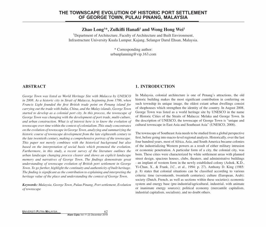
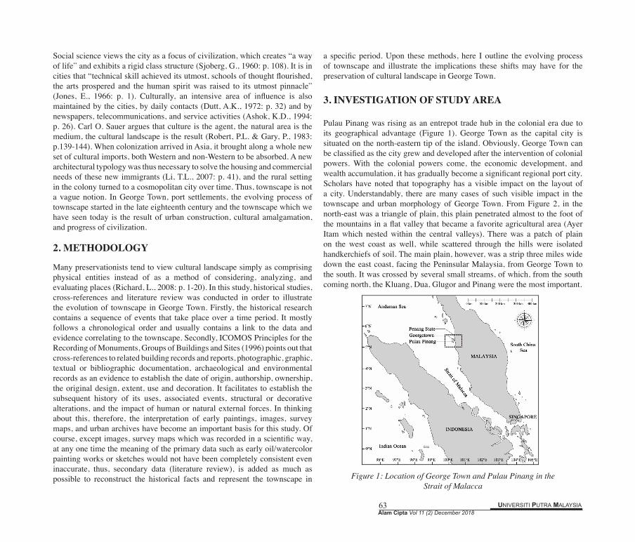
Pulau Pinang was rising as an entrepot trade hub in the colonial era due to its geographical advantage (Figure 1). George Town as the capital city is situated on the north-eastern tip of the island. Obviously, George Town can be classified as the city grew and developed after the intervention of colonial powers. With the colonial powers come, the economic development, and wealth accumulation, it has gradually become a significant regional port city. Scholars have noted that topography has a visible impact on the layout of a city. Understandably, there are many cases of such visible impact in the townscape and urban morphology of George Town. From Figure 2, in the north-east was a triangle of plain, this plain penetrated almost to the foot of the mountains in a flat valley that became a favorite agricultural area (Ayer Itam which nested within the central valleys). There was a patch of plain on the west coast as well, while scattered through the hills were isolated handkerchiefs of soil. The main plain, however, was a strip three miles wide down the east coast, facing the Peninsular Malaysia, from George Town to the south. It was crossed by several small streams, of which, from the south coming north, the Kluang, Dua, Glugor and Pinang were the most important.
Figure 1: Location of George Town and Pulau Pinang in the Strait of Malacca
Alam Cipta Vol 11 (2) December 2018UNIVERSITI PUTRA MALAYSIA 64
Figure 2: Analysis of Elevation and Geographical Morphology by Global Mapper V. 14.0
Colonialists needed to quickly and efficiently collect natural resources from colonized countries and sell newly processed goods in their territories (Lee, S.W., Song, D.W. & Ducruet, C., 2008: p. 378). Thus, they sought accessible places with deep water, large spaces, and good connections between the foreland, or the overseas region, and the hinterland, or the interior region (Kuby, M. & Reid, N., 1992: p. 272-289). Penang was ceded from Kedah in 1786 on behalf of the British East India Company by Francis Light, and the Sultan of Kedah was forced to part with additional land in 1800, which became Province Wellesley. The British secured the town of Malacca from Dutch control in 1795, after the cession of Singapore by Sir Thomas Stamford Bingley Raffles in 1819, Straits Settlement established in 1826 as part of the territories controlled by the British East India Company which consisted of the four individual settlements of Malacca, Dinding, Penang, and Singapore. These British Settlements along the Straits of Malacca that shortened the trading route and constructed a trading network and links between the English East India subcontinent and their connection with trade in the Straits, the archipelago and China. Captain Francis Light, a trader by profession, arrived in Penang on 15 July 1786 with a body of Marines and hoisted the British flag on August 1786, and rename the island “Prince of Wales Island” (Sinha, V., 2011: p. 32).
4. THE SOCIAL BASIS OF GEORGE TOWN’S TOWNSCAPE
4.1 Urban Function: Colonial Settlements and Trading Port
One insight into the social basis of George Town is through a study of the urban function. The city’s functions and its history will be used more as a means for explaining the landscape than as ends to be indicated by the landscape (Price, E.T., 1964: p. 242-275). In Southeast Asia, almost every colonial city had a port for trading activities like George Town, Singapore, Malacca, and Manila, in this sense, ports had been considered as an engine of economic development and a hub of labor resources for the regions where they were located. The spatial and functional changes in port peripheral areas have had a considerable impact on port cities, a city and a port interplay with each other as a single node in terms of economic and spatial structure (Lee, S.W., Song, D.W. & Ducruet, C., 2008: p. 372). Besides, a port as a link between the downtown area and their neighbor cities.
One of the reasons why the English acquired Penang was trade (Dianne, L., 1977: p. 17-33), the key fact is that the English believed that Penang was the best location to replace Benkulen colony, Sumatra, which was far from the main trading route (Hussin, N., 2005: p. 69). Francis Light was seeking a base for the English East India Company at the end of the Straits of Malacca, thus Light with high hopes for making Penang a naval base and a major center for trade and spice cultivation (Turnbull, C.M., 2009: p. 30-31) after the cession. In the early colonial days of Penang, George Town existed as a port town where traders sold nutmeg, pepper, cloves, betel creams and textiles to the Europeans, Chinese, Arabs, and Indians. Large ships were loaded with cloth and opium from India, small ships transported tin, rattan, bird’s nest, and pepper to Siem Reap, Sumatra and Malaya. By the early nineteenth century, British colonial towns and their hinterlands served as naval bases and ports of call for the India-China trade (Lynn, H.L., 2017: p. 17). After the signing of the Pangkor Treaty in 1874, Penang began to thrive as an export hub in the northern territories of Straits Settlement.
4.2 Cultural Pluralism: Adaptation, Transformation, and Integration
George Town, Pulau Pinang, as the former possession of British Straits Settlement during the colonial era was developing with the colonialism which expanded all over the world. In the seventeenth and eighteenth centuries, western culture was apparently sufficient to transplant, with some adaptation, transformation, and integration by the colonial governor from what were essentially pre-industrial European towns to pre-industrial colonial
UNIVERSITI PUTRA MALAYSIA 65Alam Cipta Vol 11 (2) December 2018
settlements to cater to the new social, economic, political or environmental conditions. Cultural implications of Asia and Europe gave this Southeast Asian coastal city a rich and hybrid cultural pattern, it developed into an important transportation hub of the North Malacca Strait from an insular tropical island to a colonial port town.
Like other colonial cities, the affluent and ruling classes dominated the popular culture and values, more specifically, the dominant colonial minority is culturally European. In George Town’s townscape, there are early European settlements, cemeteries, forts, customs, the supreme court and government buildings with western style. Europeans replanted their culture to the colonies, mix together with native culture and immigration culture gradually like a huge melting pot. Subsequently, cultures from Europe, East Asia, South Asia, and Southeast Asia, highlighting the characteristics of inclusiveness of George Town. In short, therefore, these symbols can be observed in the urban landscape of George Town today after a long evolution process. The administrative buildings, churches, old plazas and fortifications in George Town represents the quintessential urban landscape of British colonialism since the late eighteenth century.
4.3 Immigrant Communities
The colonial city, like colonialism itself, provided the setting for the encounter of races and civilizations - yet one that took place in a situation of structured inequality (Ashok, K.D., 1994: p. 26). When Francis Light occupied Penang, his stall only five members. Apart from these, European civilians numbered only fourteen; two merchants, a tavern-keeper, a ship’s carpenter, a caulker, a cooper, a planter, a dealer, a blacksmith, a builder, a shopkeeper, a beach-master, a mariner and a shipbuilder (City Council of George Town, 1966: p. 1).
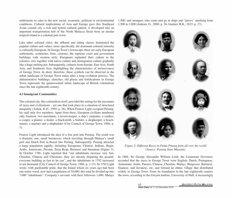
Francis Light introduced the idea of a free port into Penang. The result was a dramatic one, small businesses which traveling through Malaya’s small port and Dutch Port in-fluxed into Penang. Subsequently, Penang attracted a large population rapidly, including Europeans, Chinese, Indians, Bugis, Arabs, Americans, Persian, Siem Reap, Burmese and Sumatran (Figure 3). In October 1786, Light reported that “our inhabitants increase very fast, Choolias, Chinese and Christians, they are already disputing the ground, everyone building as fast as he can”, and the inhabitants in 1792 increased to ten thousand (City Council of George Town, 1966: p. 1-13). In 1792 Light wrote, with pardonable pride, that the Island which six years ago had been one entire wood, now had a population of 10,000; this total he divided up into 7,000 “inhabitants”; Company’s servants with their followers 1,000; Malays
1,500; and strangers who come and go in ships and “prows” anything from 1,500 to 2,000 (Jenkins, G., 2008: p. 36; Garnier, R.K., 2015: p. 17).
Figure 3: Different Races in Pulau Pinang from all over the world (Source: Penang State Museum)
In 1804, Sir George Alexander William Leith, the Lieutenant Governor, recorded that the races in George Town were English, Dutch, Portuguese, Armenians, Arabs, Parsees, Chinese, Choolias, Malays, Burgesses, Burmese, Siamese, and Javanese, etc. and formed an ethnic village that distributed widely in George Town. From its foundation in the late eighteenth century the town, according to the Gwynn Jenkins, University of Hull, it increasingly
Alam Cipta Vol 11 (2) December 2018UNIVERSITI PUTRA MALAYSIA 66
attractive to traders, craftspeople, and laborers from various parts of Asia and the Middle East, though there had been significant local settlement prior to the arrival of the British, and the expanding population comprised Malays, Armenians, Arabs, Parsees, Burmese, Siamese, Bugis, and Javanese, Chinese (mainly Hokkien, Cantonese, Teow Chew, Hakka, and Hainanese), Indians (Hindu and Muslim, mainly from south India, though there were also Sikhs, Bengalis, and Gujaratis, among others), as well as Portuguese, Dutch, Japanese and British. Cheap labor was also brought from India and China under an indentured immigration system (Jenkins, G., & King, V.T., 2003: p. 46-48). Influxes of immigrants make up Penang’s population that came in large numbers in the eighteenth, nineteenth, twentieth centuries, the most representative one is immigrants that from southern China, and today, large-scale Malaysian Chinese take up nearly half of the population of Penang. In 2016, the total population of Penang is 1,719,300 with a Malaysian Chinese population of 689,300. The Malaysian Chinese population accounted for 40.1% of the total population. (Department of statistics of Malaysia, Population Quick Info).
From the late eighteenth century, the multi-cultural context of Georgetown started growing, different cultures intertwined with urban development and reflected on the townscape, making the city a perfect crossroad for the meeting of Eastern and Western cultures. Immigrants from Europe, China and Indian brought construction methods and rules from their hometown respectively to George Town. Consequently, it is normal in a colony that the townscape is changing with the economic and social development, and meanwhile reflects rich culture or great diversity from several dimensions in the scenery, for instance, global forces, the value of ethnic communities, religious or worship, ritual symbolism, and construction traditions.
5. TOWNSCAPE OF GEORGE TOWN IN THE LATE EIGHTEENTH CENTURY
As aforementioned, the influences of Asia and Europe have endowed the George Town with a specific multicultural heritage that is both tangible and intangible. With its government buildings, churches, squares, and fortifications, George Town represents the British era from the end of the eighteenth century. According to the records, the first British fleet visit Penang was in 1592, when Captain James Lancaster anchored the Edward Bonaventure in Penang. James and his sailors got scurvy, and they stayed on this island for several weeks for replenishing supplies. But in Lancaster’s navigation log, no records that mention the people living on the island. Until the late eighteenth century, Penang island was virtually uninhabited (Turnbull, C.M., 2009: p. 30), in this
stage, Penang controlled by Kedah, a Muslim kingdom, in the northern part of the Peninsula Malaysia and bordered by Siam. The cemetery found on the island in the eighteenth century proved that the indigenous people had lived on the island and the pirates lived on this island as well until they were expelled in 1750 and 1786 by the Sultan of Kedah. Before arriving of British, Penang had been the transfer station for replenishing fresh water for a long time, to some extent, it’s a sparsely populated tropical island, but evidence such as cemetery, plowed land, and planting of fruit tree showed that the earlier aborigines were living on this island.
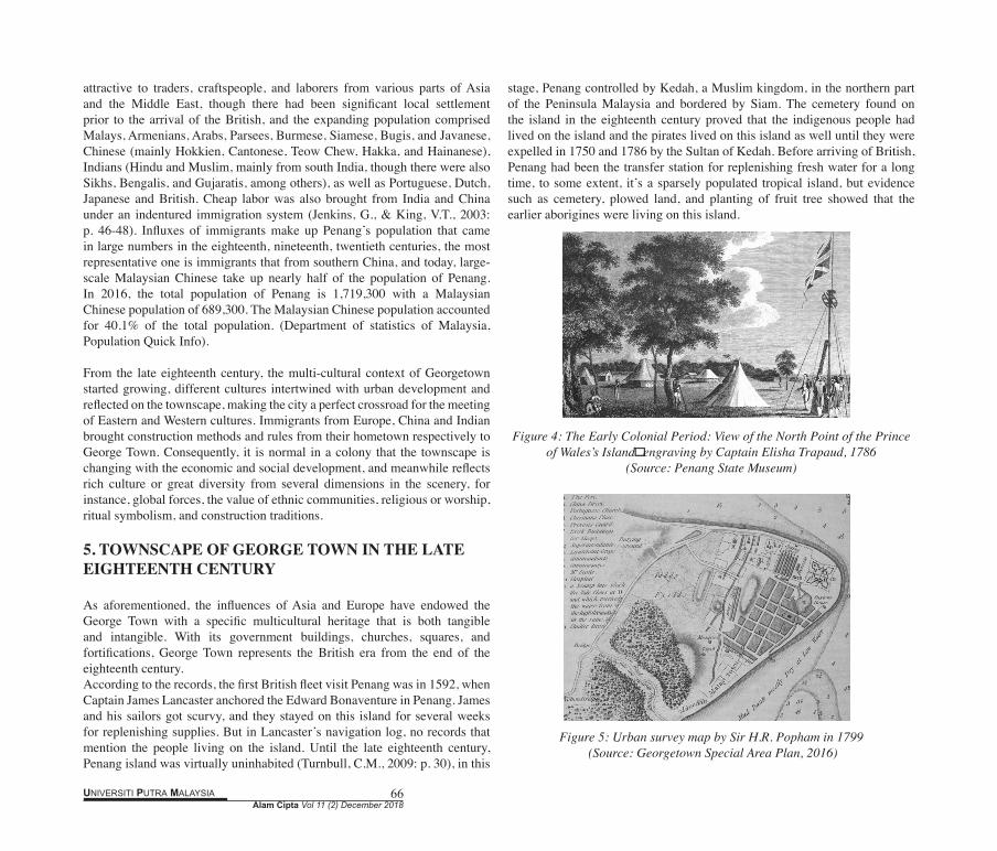
Figure 4: The Early Colonial Period: View of the North Point of the Prince of Wales’s Island,engraving by Captain Elisha Trapaud, 1786
(Source: Penang State Museum)
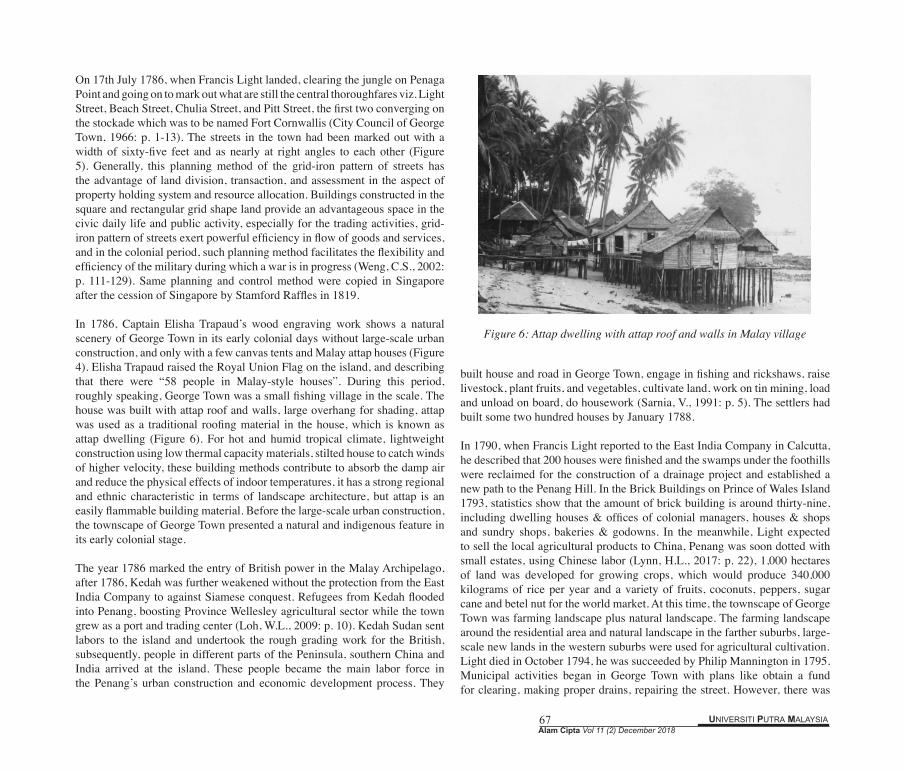
Figure 5: Urban survey map by Sir H.R. Popham in 1799
(Source: Georgetown Special Area Plan, 2016)
UNIVERSITI PUTRA MALAYSIA 67Alam Cipta Vol 11 (2) December 2018
On 17th July 1786, when Francis Light landed, clearing the jungle on Penaga Point and going on to mark out what are still the central thoroughfares viz. Light Street, Beach Street, Chulia Street, and Pitt Street, the first two converging on the stockade which was to be named Fort Cornwallis (City Council of George Town, 1966: p. 1-13). The streets in the town had been marked out with a width of sixty-five feet and as nearly at right angles to each other (Figure 5). Generally, this planning method of the grid-iron pattern of streets has the advantage of land division, transaction, and assessment in the aspect of property holding system and resource allocation. Buildings constructed in the square and rectangular grid shape land provide an advantageous space in the civic daily life and public activity, especially for the trading activities, grid-iron pattern of streets exert powerful efficiency in flow of goods and services, and in the colonial period, such planning method facilitates the flexibility and efficiency of the military during which a war is in progress (Weng, C.S., 2002: p. 111-129). Same planning and control method were copied in Singapore after the cession of Singapore by Stamford Raffles in 1819.
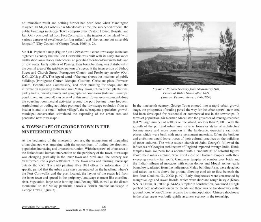
In 1786, Captain Elisha Trapaud’s wood engraving work shows a natural scenery of George Town in its early colonial days without large-scale urban construction, and only with a few canvas tents and Malay attap houses (Figure 4). Elisha Trapaud raised the Royal Union Flag on the island, and describing that there were “58 people in Malay-style houses”. During this period, roughly speaking, George Town was a small fishing village in the scale. The house was built with attap roof and walls, large overhang for shading, attap was used as a traditional roofing material in the house, which is known as attap dwelling (Figure 6). For hot and humid tropical climate, lightweight construction using low thermal capacity materials, stilted house to catch winds of higher velocity, these building methods contribute to absorb the damp air and reduce the physical effects of indoor temperatures, it has a strong regional and ethnic characteristic in terms of landscape architecture, but attap is an easily flammable building material. Before the large-scale urban construction, the townscape of George Town presented a natural and indigenous feature in its early colonial stage. The year 1786 marked the entry of British power in the Malay Archipelago, after 1786, Kedah was further weakened without the protection from the East India Company to against Siamese conquest. Refugees from Kedah flooded into Penang, boosting Province Wellesley agricultural sector while the town grew as a port and trading center (Loh, W.L., 2009: p. 10). Kedah Sudan sent labors to the island and undertook the rough grading work for the British, subsequently, people in different parts of the Peninsula, southern China and India arrived at the island. These people became the main labor force in the Penang’s urban construction and economic development process. They
built house and road in George Town, engage in fishing and rickshaws, raise livestock, plant fruits, and vegetables, cultivate land, work on tin mining, load and unload on board, do housework (Sarnia, V., 1991: p. 5). The settlers had built some two hundred houses by January 1788.
In 1790, when Francis Light reported to the East India Company in Calcutta, he described that 200 houses were finished and the swamps under the foothills were reclaimed for the construction of a drainage project and established a new path to the Penang Hill. In the Brick Buildings on Prince of Wales Island 1793, statistics show that the amount of brick building is around thirty-nine, including dwelling houses & offices of colonial managers, houses & shops and sundry shops, bakeries & godowns. In the meanwhile, Light expected to sell the local agricultural products to China, Penang was soon dotted with small estates, using Chinese labor (Lynn, H.L., 2017: p. 22), 1,000 hectares of land was developed for growing crops, which would produce 340,000 kilograms of rice per year and a variety of fruits, coconuts, peppers, sugar cane and betel nut for the world market. At this time, the townscape of George Town was farming landscape plus natural landscape. The farming landscape around the residential area and natural landscape in the farther suburbs, large-scale new lands in the western suburbs were used for agricultural cultivation. Light died in October 1794, he was succeeded by Philip Mannington in 1795. Municipal activities began in George Town with plans like obtain a fund for clearing, making proper drains, repairing the street. However, there was
Figure 6: Attap dwelling with attap roof and walls in Malay village
Alam Cipta Vol 11 (2) December 2018UNIVERSITI PUTRA MALAYSIA 68
no immediate result and nothing further had been done when Mannington resigned. In Major Forbes Ross Macdonald’s time, the succeeded official, the public buildings in George Town comprised the Custom House, Hospital and Jail. Only one road led from Fort Cornwallis to the interior of the island “with various degrees of excellence for four miles”, and “the rest are but miserable footpath” (City Council of George Town, 1966: p. 2).
Sir H.R. Popham’s map (Figure 5) in 1799 shows a clear townscape in the late eighteenth century that the Fort Cornwallis was built with its early stockades and bastions on all faces and corners, no piers had then been built in the tideland or low water. Early settlers of Penang, their brick building was distributed in the central area of the grid-iron pattern of streets, at the intersection of Bishop Street and Church Street, Portuguese Church and Presbytery nearby (Ooi, K.G., 2002: p. 57). The legend word of the map shows the locations of public buildings (Portuguese Church, Mosque, Customs, Christians place, Provosts Guard, Hospital and Commissary) and brick building for shops, and the information regarding to the land use (Malay Town, China Street, plantations, paddy fields, burial ground) and geographical conditions (tideland, swamps, pond, river, and mound) can be read in this map. Town areas expanded along the coastline, commercial activities around the port became more frequent. Agricultural or trading activities promoted the townscape evolution from an insular island to a small “urban village”, the subsequent population growth, municipal construction stimulated the expanding of the urban area and generated new townscape.
6. TOWNSCAPE OF GEORGE TOWN IN THE NINETEENTH CENTURY
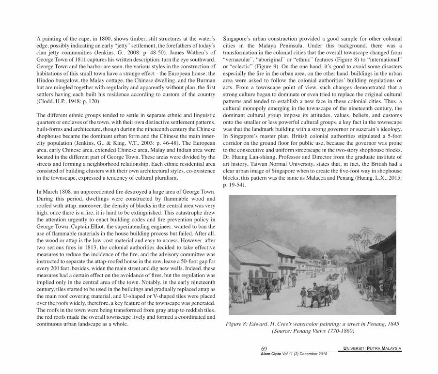
At the beginning of the nineteenth century, the momentum of impending urban changes was emerging with the concomitant of trading development, population increasing and urban construction. With the sprawl of urban area in the flatlands and human intervention on the periphery of the town, townscape was changing gradually in the inner town and rural area, the scenery was transformed into a port settlement in the town area and farming landscape outside the town. The early painting after 1821 offers the information of a specific period that the urban area was concentrated on the headland where’s the Fort Cornwallis and the port located, the layout of the roads led from the inner town and spread in the periphery, landscape element like coastline, river, vegetation, large-scale farming land, Penang Hill, as well as the distant mountains on the Malay peninsula shows a British bucolic landscape in George Town (Figure 7) .
Figure 7: Natural Scenery from Strawberry Hill, Prince of Wales Island after 1821
(Source: Penang Views, 1770-1860)
In the nineteenth century, George Town entered into a rapid urban growth stage, the prosperous of trading paved the way for the urban sprawl, new area had been developed for residential or commercial use in the townships. In terms of population, Sir Norman Macalister, the governor of Penang, recorded that “a large number of settlers on the island, no less than 2,000”. With the growth of the port and urban area, diverse forms or styles of architecture became more and more common in the landscape, especially sacrificial places which were built with more permanent materials. Often the builders and craftsmen would leave traces of their cultural practices on the buildings of other cultures. The white stucco church of Saint George’s followed the influences of Georgian architecture of England imported through India. Hindu temples from southern India adorned with a “mountain” of colorful figures above their main entrance, were sited close to Hokkien temples with their sweeping swallow tail roofs, Cantonese temples of somber grey brick and the Indian-influenced mosques with onion domes and Mogul arches, early bungalows, adapted from the indigenous Malay building form, were detached and raised on stilts above the ground allowing cool air to flow beneath the first floor (Jenkins, G., 2008: p. 49). Early shophouses were constructed by mangrove logs and sawed boards, which were short and rough in style (Khoo, S.N. & Halim, B., 2009: p. 54-65), simpler in construction, contained a single pitched roof, no decoration on the facade and there was no five-foot way in the ground floor. When Chinese became the main population, Chinese shophouse in the urban areas was built rapidly as a new scenery in the township.
UNIVERSITI PUTRA MALAYSIA 69Alam Cipta Vol 11 (2) December 2018
A painting of the cape, in 1800, shows timber, stilt structures at the water’s edge, possibly indicating an early “jetty” settlement, the forefathers of today’s clan jetty communities (Jenkins, G., 2008: p. 48-50). James Wathen’s of George Town of 1811 captures his written description: turn the eye southward, George Town and the harbor are seen, the various styles in the construction of habitations of this small town have a strange effect - the European house, the Hindoo bungalow, the Malay cottage, the Chinese dwelling, and the Burman hut are mingled together with regularity and apparently without plan, the first settlers having each built his residence according to custom of the country (Clodd, H.P., 1948: p. 120).
The different ethnic groups tended to settle in separate ethnic and linguistic quarters or enclaves of the town, with their own distinctive settlement patterns, built-forms and architecture, though during the nineteenth century the Chinese shophouse became the dominant urban form and the Chinese the main inner-city population (Jenkins, G., & King, V.T., 2003: p. 46-48). The European area, early Chinese area, extended Chinese area, Malay and Indian area were located in the different part of George Town. These areas were divided by the streets and forming a neighborhood relationship. Each ethnic residential area consisted of building clusters with their own architectural styles, co-existence in the townscape, expressed a tendency of cultural pluralism.
In March 1808, an unprecedented fire destroyed a large area of George Town. During this period, dwellings were constructed by flammable wood and roofed with attap, moreover, the density of blocks in the central area was very high, once there is a fire, it is hard to be extinguished. This catastrophe drew the attention urgently to enact building codes and fire prevention policy in George Town, Captain Elliot, the superintending engineer, wanted to ban the use of flammable materials in the house building process but failed. After all, the wood or attap is the low-cost material and easy to access. However, after two serious fires in 1813, the colonial authorities decided to take effective measures to reduce the incidence of the fire, and the advisory committee was instructed to separate the attap-roofed house in the row, leave a 50-foot gap for every 200 feet, besides, widen the main street and dig new wells. Indeed, these measures had a certain effect on the avoidance of fires, but the regulation was implied only in the central area of the town. Notably, in the early nineteenth century, tiles started to be used in the buildings and gradually replaced attap as the main roof covering material, and U-shaped or V-shaped tiles were placed over the roofs widely, therefore, a key feature of the townscape was generated. The roofs in the town were being transformed from gray attap to reddish tiles, the red roofs made the overall townscape lively and formed a coordinated and continuous urban landscape as a whole.
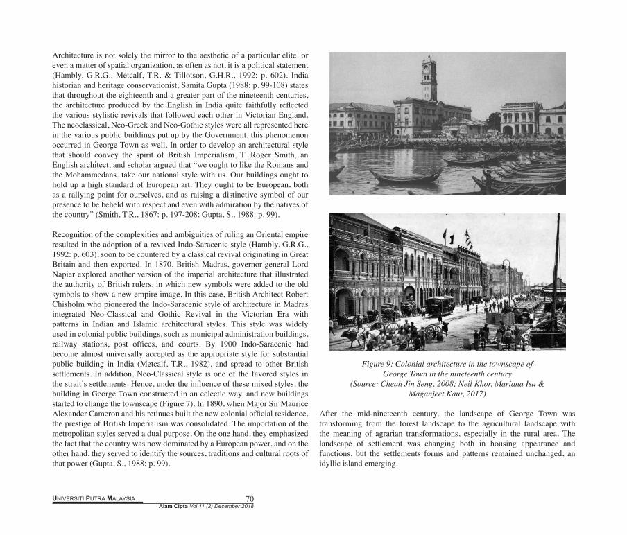
Singapore’s urban construction provided a good sample for other colonial cities in the Malaya Peninsula. Under this background, there was a transformation in the colonial cities that the overall townscape changed from “vernacular”, “aboriginal” or “ethnic” features (Figure 8) to “international” or “eclectic” (Figure 9). On the one hand, it’s good to avoid some disasters especially the fire in the urban area, on the other hand, buildings in the urban area were asked to follow the colonial authorities’ building regulations or acts. From a townscape point of view, such changes demonstrated that a strong culture began to dominate or even tried to replace the original cultural patterns and tended to establish a new face in these colonial cities. Thus, a cultural monopoly emerging in the townscape of the nineteenth century, the dominant cultural group impose its attitudes, values, beliefs, and customs onto the smaller or less powerful cultural groups, a key fact in the townscape was that the landmark building with a strong governor or suzerain’s ideology. In Singapore’s master plan, British colonial authorities stipulated a 5-foot corridor on the ground floor for public use, because the governor was prone to the consecutive and uniform streetscape in the two-story shophouse blocks. Dr. Huang Lan-shiang, Professor and Director from the graduate institute of art history, Taiwan Normal University, states that, in fact, the British had a clear urban image of Singapore when to create the five-foot way in shophouse blocks, this pattern was the same as Malacca and Penang (Huang, L.X., 2015: p. 19-54).
Figure 8: Edward. H. Cree’s watercolor painting: a street in Penang, 1845
(Source: Penang Views 1770-1860)
Alam Cipta Vol 11 (2) December 2018UNIVERSITI PUTRA MALAYSIA 70
Architecture is not solely the mirror to the aesthetic of a particular elite, or even a matter of spatial organization, as often as not, it is a political statement (Hambly, G.R.G., Metcalf, T.R. & Tillotson, G.H.R., 1992: p. 602). India historian and heritage conservationist, Samita Gupta (1988: p. 99-108) states that throughout the eighteenth and a greater part of the nineteenth centuries, the architecture produced by the English in India quite faithfully reflected the various stylistic revivals that followed each other in Victorian England. The neoclassical, Neo-Greek and Neo-Gothic styles were all represented here in the various public buildings put up by the Government, this phenomenon occurred in George Town as well. In order to develop an architectural style that should convey the spirit of British Imperialism, T. Roger Smith, an English architect, and scholar argued that “we ought to like the Romans and the Mohammedans, take our national style with us. Our buildings ought to hold up a high standard of European art. They ought to be European, both as a rallying point for ourselves, and as raising a distinctive symbol of our presence to be beheld with respect and even with admiration by the natives of the country” (Smith, T.R., 1867: p. 197-208; Gupta, S., 1988: p. 99).
Recognition of the complexities and ambiguities of ruling an Oriental empire resulted in the adoption of a revived Indo-Saracenic style (Hambly, G.R.G., 1992: p. 603), soon to be countered by a classical revival originating in Great Britain and then exported. In 1870, British Madras, governor-general Lord Napier explored another version of the imperial architecture that illustrated the authority of British rulers, in which new symbols were added to the old symbols to show a new empire image. In this case, British Architect Robert Chisholm who pioneered the Indo-Saracenic style of architecture in Madras integrated Neo-Classical and Gothic Revival in the Victorian Era with patterns in Indian and Islamic architectural styles. This style was widely used in colonial public buildings, such as municipal administration buildings, railway stations, post offices, and courts. By 1900 Indo-Saracenic had become almost universally accepted as the appropriate style for substantial public building in India (Metcalf, T.R., 1982), and spread to other British settlements. In addition, Neo-Classical style is one of the favored styles in the strait’s settlements. Hence, under the influence of these mixed styles, the building in George Town constructed in an eclectic way, and new buildings started to change the townscape (Figure 7). In 1890, when Major Sir Maurice Alexander Cameron and his retinues built the new colonial official residence, the prestige of British Imperialism was consolidated. The importation of the metropolitan styles served a dual purpose, On the one hand, they emphasized the fact that the country was now dominated by a European power, and on the other hand, they served to identify the sources, traditions and cultural roots of that power (Gupta, S., 1988: p. 99).
Figure 9: Colonial architecture in the townscape of George Town in the nineteenth century
(Source: Cheah Jin Seng, 2008; Neil Khor, Mariana Isa & Maganjeet Kaur, 2017)
After the mid-nineteenth century, the landscape of George Town was transforming from the forest landscape to the agricultural landscape with the meaning of agrarian transformations, especially in the rural area. The landscape of settlement was changing both in housing appearance and functions, but the settlements forms and patterns remained unchanged, an idyllic island emerging.

UNIVERSITI PUTRA MALAYSIA 71Alam Cipta Vol 11 (2) December 2018
The discovery of tin in Perak and Selangor in the 1840s turned Penang into an intra-Straits gateway to Peninsular Malaya, Tin transformed the town (Goh, D.P.S. 2014: p. 89). Moreover, in the 1840s, steam engines would drain the swamps and power refineries, with the demand for sugar rising, adventurers of many sorts turned swamps into sugar plantations, albeit without much machinery (Lynn, H.L., 2017: p. 25-26). The sugarcane plantations in Province Wellesley employed a lot of Malay labors, and labors from Java, south China, India, Myanmar, and even Arab. After the First Anglo-Chinese War (1839-1842) in the mid-nineteenth century that provided the bulk of immigrants, Chinese immigrants in Penang increased markedly, the town grew denser. The newcomers from Guangdong and Fujian brought the vernacular construction technology from their hometown to the new settlement, some architectural details in southern China were applied in George Town shophouse, and to the end, had a strong impact on the townscape.
With the renewal of the land policy in the late nineteenth century, a land survey was carried out in 1886. Subsequently, burning of forest land for the cultivation of crops happened rapidly, the flatlands of the island turned to farmlands and settlements on a massive scale, deforestation occurred in the forest area which adjoined the hilly zone. In some ways, to the contrary, the construction of public buildings, road, railway, and bridge was rather active in these regions, there is a sharp secular change in the overall townscape. Following Singapore harbor’s footstep, the first section of Weld Quay was reserved for government offices and its administrative center. Over a course of twenty years from 1884, a number of government offices were built: The General Post Office, the Government Telegraphy Office and the Government Telegraphy Exchange, the Government’s Office, the Resident Councilor’s Office, the Audit Office, the Public Work Department, the Land Office, and the Marine Department (including the Harbor Master’s Office and the Office of the Solicitor-General) (Brochure of The House of Yeap Chor Ee, p. 5-9).
Building regulations in the 1880s showed that all of the buildings should be erected of strong, durable materials such as bricks, tiles, and reserved a five-foot walkway in front of the door. Townscape was changed under the building regulations, and dirty, decrepit wooden houses in the townships were replaced by brick, red tiles and tidy shophouse with a continuous corridor, and wider lanes between the buildings could be used for preventing the big fire. The width of these old shophouses is usually between thirteen and twenty feet, and the depth at least two or three times the width, and wooden shutters either plain or louvers were used for the windows on the upper floor (Wan
Hashimah & Shuhana, 2005, p. 7), the regulations of 1880’s, combined with design principles imported from the west, initiated the advent of the typical two-story old shophouse (Yeang, K., 1992: p. 23-40).
According to the observation of Isabella Bird (1831-1904), an England globetrotter, she described the townscape of George Town by in 1880s was that “as one lands on Pinang one is impressed even before reaching the shore by the blaze of color in the costumes of the crowds which throng the jetty......, the sight of the Asiatics who have crowded into Georgetown is a wonderful one, Chinese, Burmese, Javanese, Arabs, Malays, Sikhs, Madrassees, Klings, Chuliahs, and Parsees, and still they come in junks and steamers and strange Arabian craft, and all get a living, depend slavishly on no one, never lapse into pauperism, retain their own dress, customs, and religion, and are orderly......, there are about six hundred and twelve Europeans in the town......, but they make little show, though their large massive bungalows......give one the idea of wealth and solidity” (Turnbull, C.M., 2009: p. 3).
Besides, vehicles in the townscape of the late nineteenth century is an interesting facet, trams, carriage, jinrikisha, gharry, and bullocks brought vitality to the urban daily life and townscape. The wealthiest class had their carriage, but most of the citizens used jinrikisha or gharry was common. In the 1880s, the only regular public transport was that provided by the enterprising Mr. Gardner, whose trams ran on the Ayer Itam Road and Waterfall Roads. There were eleven cars on these routes in 1890, and a line of light rails for the horse-drawn cars was opened from Magazine Road along Penang Road and Chuila Street to Weld Quay (City Council of George Town, 1966: p. 52).
7. TOWNSCAPE OF GEORGE TOWN IN THE TWENTIETH CENTURY
The townscape in the twentieth century witnessed the introduction of European architectural elements and features from the Art Nouveau and Art Deco movements, as well as Modernism styles. Yet a substantial part of the general fabric, appearance, cultural vibrancy and ethnic diversity of the inner city have managed to survive up until quite recently (Jenkins, G., & King, V.T., 2003: p. 46-48). During this period, the eclectic buildings emerging. this style blended eastern and western architectural elements and was used in the shophouses, temples, ancestral halls, villas, and bungalows. Furthermore, reinforced concrete was used in the construction process to meet the needs of wider roof and overhang (Figure 10).
Alam Cipta Vol 11 (2) December 2018UNIVERSITI PUTRA MALAYSIA 72
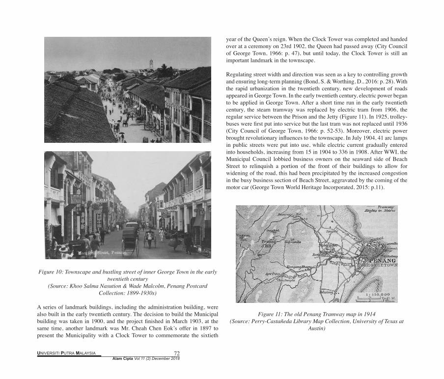
Figure 10: Townscape and bustling street of inner George Town in the early twentieth century
(Source: Khoo Salma Nasution & Wade Malcolm, Penang Postcard Collection: 1899-1930s)
A series of landmark buildings, including the administration building, were also built in the early twentieth century. The decision to build the Municipal building was taken in 1900, and the project finished in March 1903, at the same time, another landmark was Mr. Cheah Chen Eok’s offer in 1897 to present the Municipality with a Clock Tower to commemorate the sixtieth
year of the Queen’s reign. When the Clock Tower was completed and handed over at a ceremony on 23rd 1902, the Queen had passed away (City Council of George Town, 1966: p. 47), but until today, the Clock Tower is still an important landmark in the townscape.
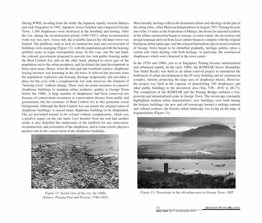
Regulating street width and direction was seen as a key to controlling growth and ensuring long-term planning (Bond, S. & Worthing, D., 2016: p. 28). With the rapid urbanization in the twentieth century, new development of roads appeared in George Town. In the early twentieth century, electric power began to be applied in George Town. After a short time run in the early twentieth century, the steam tramway was replaced by electric tram from 1906, the regular service between the Prison and the Jetty (Figure 11). In 1925, trolley-buses were first put into service but the last tram was not replaced until 1936 (City Council of George Town, 1966: p. 52-53). Moreover, electric power brought revolutionary influences to the townscape. In July 1904, 41 arc lamps in public streets were put into use, while electric current gradually entered into households, increasing from 15 in 1904 to 336 in 1908. After WWI, the Municipal Council lobbied business owners on the seaward side of Beach Street to relinquish a portion of the front of their buildings to allow for widening of the road, this had been precipitated by the increased congestion in the busy business section of Beach Street, aggravated by the coming of the motor car (George Town World Heritage Incorporated, 2015: p.11).
Figure 11: The old Penang Tramway map in 1914(Source: Perry-Castañeda Library Map Collection, University of Texas at
Austin)
UNIVERSITI PUTRA MALAYSIA 73Alam Cipta Vol 11 (2) December 2018
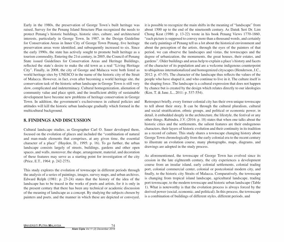
During WWII, invading from the north, the Japanese rapidly overran Malaya and took Singapore in 1942, Japanese forces bombed and conquered George Town, 1,100 shophouses were destroyed in the bombing and looting. After the war, during the reconstruction period (1946-1951), urban reconstruction work was very slow, worse still, the available land in the old inner town was limited. The problems such as lack of construction land and overcrowded of buildings were emerging (Figure 12), with the population growth the housing problem acute in major metropolitan areas. In this case, one the one hand, the colonial government proposed to provide low rent public housing under the Rent Control Act, and on the other hand, planned to move part of the population out to the urban periphery, and facilitated the land development in these rural areas. Hence, from the mid and late twentieth century, shophouse leasing business was booming in the old town. It relieved the pressure from the population explosion and housing shortage temporarily and provided a place for the civic with a comparatively low rent, however, the situation of “housing crisis” without change. There were no actual measures to conserve shophouse buildings or maintain urban aesthetics quality in George Town before the 1980s. A large number of shophouses had been conserved not because of conservation awareness or conservation decrees from public and government, but the existence of Rent Control Act in this particular social background. Although the Rent Control Act can ensure the original status of shophouse buildings, it caused many shophouse buildings to be dilapidated. The act prevented tenants to be evicted without compensation, which was a positive aspect on the one hand. Low benefits from the rent had another result, it also dispelled the enthusiasm of the landlord for any renovation, reconstruction, and restoration of the shophouse, and to some extent, played a positive role in the conservation of the shophouse buildings.
Figure 12: Aerial view of the city, the 1960s(Source: Penang Past and Present, 1786-1963)
More broadly, heritage reflects the dominant culture and ideology on the part of the ruling elites. After Malayan Independence in August 1957, Penang became one of the 13 states in the Federation of Malaya, the desire for national symbols in the urban construction began to emerge, to some extent, the decoration and design language derived from local culture began to compete with the original European urban landscape, and the original harmonious physical environment of George Town began to be disturbed gradually, heritage politics plays a certain role when dealing with built heritage, in particular, the commercial shophouses which were clustered in the town center.
In the 1970s and 1980s, just as in Singapore, Penang became industrialized and urbanized rapidly. In the early 1980s, the KOMTAR Tower (Kompleks Tun Abdul Razak) was built as an urban renewal project to transferred the bottleneck of urban development to the 65-story building and its commercial complex, thereby protecting the large area of shophouse blocks. However, the project was built at the expense of demolishing 250 shophouses and other public buildings in the downtown area (Tan, Y.W., 2016: p. 68-77). The completion of the KOMTAR and the Penang Bridge outlined a fast-growing and industrialized scene in George Town. The townscape constantly highlighted modern urban characteristics, new buildings were built among the historic buildings, the new and old townscape formed a striking contrast and cultural contrast, the historic urban landscape was living on the edge of fragmentation (Figure 13).
Figure 13: Townscape in the old urban area in George Town, 1985
Alam Cipta Vol 11 (2) December 2018UNIVERSITI PUTRA MALAYSIA 74
Early in the 1980s, the preservation of George Town’s built heritage was raised, Survey for the Penang Island Structure Plan recognized the needs to protect Penang’s historic buildings, historic sites, culture, and architectural interests, particularly in George Town. In 1987, in the Design Guideline for Conservation Areas in Inner City of George Town Penang, five heritage preservation areas were identified, and subsequently increased to six. Since the early 1990s, the state has actively sought to promote built heritage as a tourism commodity. Entering the 21st century, in 2005, the Council of Penang State issued Guidelines for Conservation Areas and Heritage Buildings, reflected the state’s desire to make the old town as a real “Living Heritage City”. Finally, in 2008, the city of George and Malacca were both listed as world heritage sites by UNESCO in the name of the historic city of the Strait of Malacca. However, in fact, even after becoming a world heritage site, the conservation task of the historic urban landscape in George Town is still very slow, complicated and indeterminacy. Cultural homogenization, alienation of community value and place spirit, and the insufficient ability of sustainable development have become new problems of heritage conservation in George Town. In addition, the government’s exclusiveness in cultural policies and attitudes will kill the historic urban landscape gradually which formed in the multicultural background.
8. FINDINGS AND DISCUSSION
Cultural landscape studies, as Geographer Carl O. Sauer developed them, focused on the evolution of places and included the “combination of natural and man-made elements that comprises, at any given time, the essential character of a place” (Hayden, D., 1995: p. 16). To go further, the urban landscape consists largely of streets, buildings, gardens and other open spaces, and walls, moreover, the shape, arrangement, material, and decoration of these features may serve as a starting point for investigation of the city (Price, E.T., 1964: p. 242-275).
This study explores the evolution of townscape in different periods through the analysis of a series of paintings, images, survey maps, and urban archives. Edward Relph (1981: p. 23-24) states that the history of the idea of the landscape has to be traced in the works of poets and artists, for it is only in the present century that there has been any technical or academic discussion of the meaning of landscape as a concept. By studying the subjects chosen by painters and poets, and the manner in which these are depicted or conveyed,
it is possible to recognize the main shifts in the meaning of “landscape” from about 1500 up to the end of the nineteenth century. As Datuk Seri Dr. Lim Chong Keat (1986: p. 13-22) wrote in his book Penang Views 1770-1860, “each picture is supposed to convey more than a thousand words, and certainly the early paintings of Penang tell us a lot about the historical environment and about the perception of the artists, through the eyes of the painters of that period, we can observe the landscapes and vistas, the townscapes and the degree of urbanization, the monuments, the great houses, their estates, and gardens”. Older buildings and areas help to explain a place’s history and facets of the character of its population and are a welcome indigenous counterpoint to ubiquitous internationalized and homogenized cityscapes (Henderson, J.C., 2012: p. 47-55). The character of the landscape thus reflects the values of the people who have shaped it, and who continue to live in it. The culture itself is the shaping force. The landscape is a cultural expression that does not happen by chance but is created by the design which relates directly to our ideologies (Ken, T. & Jane, L., 2011: p. 537-554).
Retrospect briefly, every former colonial city has their own unique townscape to tell about their story. It can be through the cultural pluralism, cultural and social stratification, ethnic groups, and political or economic power, in detail, it embedded deeply in the architecture, the lifestyle, the festival or any other things. Rabindra, J.V. (2016: p. 18) states that when one talks about the historic cities and the settlements, the salient features are their endogenous characters, their layers of historic evolution and their continuity in its tradition as a record of culture. This study shares a townscape changing history about George Town chronologically from the early colonial era to the recent century to illustrate an evolution course, many photographs, maps, diagrams, and drawings are adopted in the study process.
As aforementioned, the townscape of George Town has evolved since its cession in the late eighteenth century, the city experiences a development course from an insular island, early colonial settlements, colonial trading port, colonial commercial center, colonial or postcolonial modern city, and finally, to the historic city Straits of Malacca. Comparatively, the townscape is changing from tropical island landscape, agricultural landscape, trading port townscape, to the modern townscape and historic urban landscape (Table 1). What is noteworthy is that the evolution process is always forced by the derived power (social, economic, and political). In this process, the townscape is a combination of buildings of different styles, different periods, and
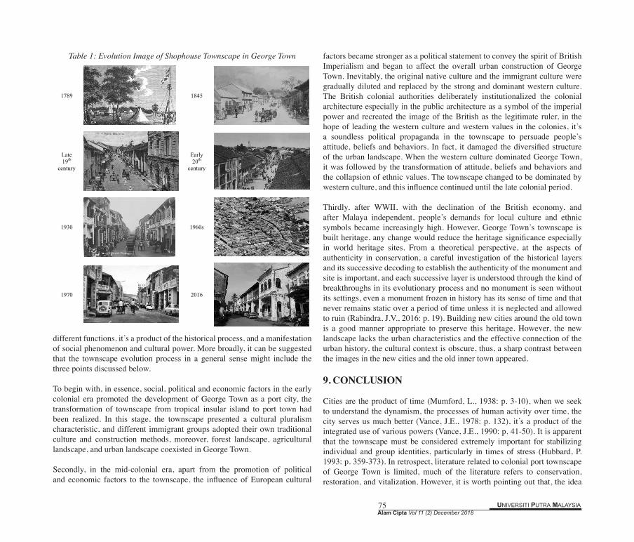
UNIVERSITI PUTRA MALAYSIA 75Alam Cipta Vol 11 (2) December 2018
Table 1: Evolution Image of Shophouse Townscape in George Town
different functions, it’s a product of the historical process, and a manifestation of social phenomenon and cultural power. More broadly, it can be suggested that the townscape evolution process in a general sense might include the three points discussed below.
To begin with, in essence, social, political and economic factors in the early colonial era promoted the development of George Town as a port city, the transformation of townscape from tropical insular island to port town had been realized. In this stage, the townscape presented a cultural pluralism characteristic, and different immigrant groups adopted their own traditional culture and construction methods, moreover, forest landscape, agricultural landscape, and urban landscape coexisted in George Town.
Secondly, in the mid-colonial era, apart from the promotion of political and economic factors to the townscape, the influence of European cultural
factors became stronger as a political statement to convey the spirit of British Imperialism and began to affect the overall urban construction of George Town. Inevitably, the original native culture and the immigrant culture were gradually diluted and replaced by the strong and dominant western culture. The British colonial authorities deliberately institutionalized the colonial architecture especially in the public architecture as a symbol of the imperial power and recreated the image of the British as the legitimate ruler, in the hope of leading the western culture and western values in the colonies, it’s a soundless political propaganda in the townscape to persuade people’s attitude, beliefs and behaviors. In fact, it damaged the diversified structure of the urban landscape. When the western culture dominated George Town, it was followed by the transformation of attitude, beliefs and behaviors and the collapsion of ethnic values. The townscape changed to be dominated by western culture, and this influence continued until the late colonial period.
Thirdly, after WWII, with the declination of the British economy, and after Malaya independent, people’s demands for local culture and ethnic symbols became increasingly high. However, George Town’s townscape is built heritage, any change would reduce the heritage significance especially in world heritage sites. From a theoretical perspective, at the aspects of authenticity in conservation, a careful investigation of the historical layers and its successive decoding to establish the authenticity of the monument and site is important, and each successive layer is understood through the kind of breakthroughs in its evolutionary process and no monument is seen without its settings, even a monument frozen in history has its sense of time and that never remains static over a period of time unless it is neglected and allowed to ruin (Rabindra, J.V., 2016: p. 19). Building new cities around the old town is a good manner appropriate to preserve this heritage. However, the new landscape lacks the urban characteristics and the effective connection of the urban history, the cultural context is obscure, thus, a sharp contrast between the images in the new cities and the old inner town appeared.
9. CONCLUSION
Cities are the product of time (Mumford, L., 1938: p. 3-10), when we seek to understand the dynamism, the processes of human activity over time, the city serves us much better (Vance, J.E., 1978: p. 132), it’s a product of the integrated use of various powers (Vance, J.E., 1990: p. 41-50). It is apparent that the townscape must be considered extremely important for stabilizing individual and group identities, particularly in times of stress (Hubbard, P. 1993: p. 359-373). In retrospect, literature related to colonial port townscape of George Town is limited, much of the literature refers to conservation, restoration, and vitalization. However, it is worth pointing out that, the idea
1789
1845
Late 19th
century
Early 20th
century
1930
1960s
1970
2016
Alam Cipta Vol 11 (2) December 2018UNIVERSITI PUTRA MALAYSIA 76
of townscape evolution analysis is fundamental to the conservation activity in George Town. Establishing and analyzing the character, dynamics, and setting of the townscape in the evolution process helps to interpret the value of local history, place spirit, the background of multi-culture, and seeks to understand the structure and vitality of George Town.
Although on a theoretical level, townscape study is only one facet that explains the complexity of historic cities, it not merely focus on the appearance description but explore the landscape narrative, intrinsic driven force and evolution mechanism as well. Urban society changes in the time-scale or at major historical conjunctures reflected on the townscape rapidly, no doubt that the evolution is constantly at work, physical build as the urban enduring feature is the direct evidence in George Town and construct a psychological link between people and place for present and future generations. Hopefully, the results of townscape evolution research of George Town will complement and reinforce the conservation work, leading to increased confidence in interpretation.
REFERENCES
Ashok, K.D., Xie, Y.C., Frank, J.C. & Zheng-Mao, Y. (1994). City Forms of China and India in Global Perspective. In Ashok, K.D., Frank, J.C., Surinder, A. & Allen, G.N., (Eds.). The Asian City: Processes of Development, Characteristics, and Planning (pp. 25-28). Netherlands: Springer.
Bond,S. & Worthing, D. (2016). Managing Built Heritage: The Role of Cultural Values and Significance, 2nd Edition. West Sussex: Wiley-Blackwell.
City Council of George Town. (1966). Penang: Past and Present 1786-1963. George Town: The City Council of George Town.
Clodd, H.P. (1948). Malaya’s First British Pioneer: The Life of Francis Light. London: Luzac.
Dutt, A.K. (1972). Daily Influence Area of Calcutta. The Journal of Tropical Geography, 35, 32-39.
Dianne, L. (1977). British Policy in the Straits of Malacca to 1819 and the Collapse of the Traditional Malay State Structure. Brook, B. (Ed.). Empire, Imperialism and Southeast Asia. Clayton: Monash Asia Institute.
Hubbard, P. (1993). The Value of Conservation: A Critical Review of Behavioral Research. Town Planning Review, 64(4), 359-373.
Garnier, R.K. (2015). Early Days in Penang. Badriyah, H.S. & Loh, W.L. (Eds). Glimpses of Penang’s Past: Reprint of Articles from JSBRAS and JMBRAS. Kuala Lumpur: Malaysian Branch of the Royal Asiatic Society.
Goh, D.P.S. (2014). Between History and Heritage: Post-Colonialism,
Globalization, and the Remaking of Malacca, Penang, and Singapore. TRaNS: Trans-Regional and -National Studies of Southeast Asia, 2(01), 79-101.
Gupta, S. (1988). Some Indian Influences on Colonial Architecture in Bombay. Bulletin of the Deccan College Research Institute, 47/48(89), 99-108.
George Town World Heritage Incorporated. (2015). George Town’s Historic Commercial & Civic Precincts. Penang: George Town World Heritage Incorporated.
Hayden, D. (1995). The Power of Place: Urban Landscape as Public History. Massachusetts: The MIT Press.
Hambly, G.R.G., Metcalf, T. R. & Tillotson, G.H.R. (1992). An Imperial Vision: Indian Architecture and Britain’s Raj. The American Historical Review, 97(2), 602.
Henderson, J.C. (2012). Conserving Heritage in South East Asia: Cases from Malaysia, Singapore, and the Philippines. Tourism Recreation Research, 37(1), 47-55.
Hussin, N. (2005). Trade and Society in the Straits of Melaka: Dutch Melaka and English Penang, 1780-1830. Singapore: National University of Singapore Press.
Huang, L.X. (2015). Historical Development of the Taiwan Shop-house before and after Japan’s Colonial Implementation of Urban Planning Act. Cities and Design, 22(06), 19-54.
ICOMOS. (1996). Principles for the Recording of Monuments, Groups of Buildings and Sites. Derived from https://www.icomos.org/charters/archives-e.pdf.
Jenkins, G. (2008). Contested Space: Cultural Heritage & Identity Reconstructions: Conservation Strategies within a Developing Asian City. Münster: LIT Verlag Münster.
Jenkins, G. & King, V.T. (2003). Heritage and development in a Malaysian city: George Town under threat? Indonesia and the Malay World, 31(89), 44-57.
Jones, E. (1966). Towns and Cities. New York, London, Toronto: Oxford University Press.
King, A.D. (1985). Colonial Cities: Global Pivots of Change. Ross R.J., & Telkamp G.J., (Eds.). Colonial Cities: Comparative Studies in Overseas History. Dordrecht: Springer.
Ken, T. & Jane, L. (2011). Cultural Landscapes: A Bridge Between Culture and Nature. International Journal of Heritage Studies, 17(6), 537-554.
Khoo, S.N. & Halim, B. (2009). Heritage House of Penang. Singapore: Marshall Cavendish Editions.
Kuby, M. & Reid, N. (1992). Technological Change and the Concentration of the US General Cargo Port System: 1970-1988. Economic Geography, 68, 272-289.
UNIVERSITI PUTRA MALAYSIA 77Alam Cipta Vol 11 (2) December 2018
Lim, C.K. (1986). Penang Views 1770-1860. Singapore: Summer Times Publishing.
Li, T.L. (2007). A Study of Ethnic Influence on the Facades of Colonial Shophouses in Singapore: A Case Study of Telok Ayer in Chinatown. Journal of Asian Architecture and Building Engineering, 6(1), 41-48.
Lee, S.W., Song, D.W. & Ducruet, C. (2008). A Tale of Asia’s World Ports: The Spatial Evolution in Global Hub Port Cities. Geoforum, 39(1), 372-385.
Loh, W.L. (2009). Penang: Region and Networks. Neil, K., Khoo, S.N., Loh, W.L. & Yeoh, S.G., (Eds.). Penang and Its Region: The Story of an Asian Entrepôt. Singapore: National University of Singapore Press.
Lynn, H.L. (2017). Planting Empire, Cultivating Subjects: British Malaya, 1786-1941. Cambridge: Cambridge University Press.
Mumford, L. (1938). The Culture of Cities. Florida: Harcourt, Brace & Company.
Metcalf, T.R. (1982). A Tradition Created: Indo-Saracenic Architecture under the Raj. History Today 32(9), Information on https://www.britishempire.co.uk/maproom/india/indosaracenic.htm
Ooi, K.G. (2002). From Colonial Outpost to Cosmopolitan Center: The Growth and Development of Georgetown, Penang, c. Late 19th century to the Late 20th century. APARP Southeast Asia Research Paper. Taipei: Academia Sinica, Program for Southeast Asian Area Studies, 57.
Price, E.T. (1964). Viterbo: Landscape of an Italian City. Annals, Association of American Geographers, 2(54), 242-275.
Rabindra, J.V. (2016). Historic Conservation: Value, Authenticity, and Integrity in the Setting. Journal of Landscape Architecture, (48), 18-20.
Relph, E.C. (1981). Rational Landscapes and Humanistic Geography. New Jersey: Branes & Noble Books.
Richard, L. (2008). Cultural Landscapes: Balancing Nature and Heritage in Preservation Practice. Minneapolis: The University of Minnesota Press.
Robert, P.L. & Gary, P. (1983). Dictionary of Human Geography. Connecticut: Greenwood Press.
Sarnia, H.H. (1991). Old Penang. Singapore: Oxford University Press. Sjoberg, G. (1960). The Pre-industrial City: Past and Present. New York:
The Free Press.Sinha, V. (2011). Religion-State Encounters in Hindu Domains from the
Straits Settlements to Singapore. Netherlands: Springer.Smith, T.R. (1867). On Buildings for Europeans Occupation in Tropical
Climates, Especially India. Paper Read at the Royal Institute of British Architects, 1854-1874, 18(1867/8): 197-208.
The House of Yeap Chor Ee (2016). China Street Ghaut. Penang: Brochure of The House of Yeap Chor Ee, 5-9.
Tan, Y.W. (2016). Shophouse Conservation: Restoration and Adaptive Design
in George Town, Penang. Wong, Y.C. & Johannes, W., (Eds.). Shophouse/Townhouse: Asian Perspectives. Singapore: National University of Singapore Press.
Turnbull, C.M. (2009). Penang’s Changing Role in the Straits Settlements, 1826-1946. Neil, K., Khoo, S.N., Loh, W.L. & Yeoh, S.G. (Eds.). Penang and Its Region: The Story of an Asian Entrepôt. Singapore: National University of Singapore Press.
UNESCO. (2008). Melaka and George Town, Historic Cities of the Straits of Malacca. Information on: https://whc.unesco.org/en/list/1223.
Vance, J.E. (1978). Geography and the Study of Cities. American Behavioral Scientist, 22(1), 131-149.
Vance, J.E. (1990). The Continuing City: Urban Morphology in Western Civilization. Maryland: Johns Hopkins University Press.
Wan Hashimah, W. I., & Shuhana, S. (2005). The Old Shophouses as Part of Malaysian Urban Heritage: The Current Dilemma. Paper presented at the 8th International Conference of the Asian Planning Schools Association, Penang, Malaysia.
Weng, C.S. (2002). Searching for Ways of Putting Urban Conservation Ideas into Practice through the Reform of Historic Districts. Journal of Architecture, (40), 111-129.
Yeang, K. (1992). The Architecture of Malaysia. Amsterdam: The Pepin Press.