sektor awam edisi 1/2012 - people.utm.my · merupakan gerbang utama atau one stop centre kepada...
TRANSCRIPT

PenaungY. Bhg. Datuk Zoal Azha bin YusofKetua Setiausaha Kementerian Sumber Asli dan Alam Sekitar
PenasihatY. Bhg. Dato’ Dr. Mohd Ali bin Mohamad NorTimbalan Ketua Setiausaha I (SA)Kementerian Sumber Asli dan Alam Sekitar
Ketua EditorFuziah binti Hj. Abu HanifahPengarah Pusat Infrastruktur Data Geospatial Negara (MaCGDI)
EditorNg Eng Guan - JUPEMShaharudin bin Idrus - LESTARIMohd Haizul bin Hod - UKKNorizam binti Che NohHamdan bin Ab. AzizMariyam binti MohamadMohd Latif bin Zainal Siti Zainun binti MohamadSalmah binti SalehFauzani binti AzamNor Zuraini binti Abdul RahimSharefah Nor Aliah binti Shareh Nordin
Rekabentuk/ JurufotoWan Faizal bin Wan MohamedNur Hafizah binti HamludNoor Effa Rizan binti Abdol RazakMuhamad Zamri bin Mustapha
PenerbitPusat Infrastruktur Data Geospatial Negara (MaCGDI)Kementerian Sumber Asli dan Alam Sekitar (NRE)Aras 7 & 8, Wisma Sumber AsliNo. 25 Persiaran Perdana, Presint 462574 Putrajaya, MalaysiaTel : +603-88861111 Faks : +603-88894851www.mygeoportal.gov.my
Penafian: Kesahihan dan ketepatan tulisan atau pendapat adalah tertakluk pada cetusan idea penyumbang artikel
Kandungan
dari meja Ketua Editor
Assalamualaikum, Salam Sejahtera dan Salam 1Malaysia
Sistem Maklumat Geogafi (GIS) kian menunjangkan keperkasaan teknologinya ke seluruh pelusuk agensi dan Jabatan dalam mempertingkatkan sistem penyampaian perkhidmatan dan mewujudkan pangkalan data geospatial yang komprehensif.
Umum mengetahui, negara sedang berhadapan dengan persekitaran yang dinamik oleh kepesatan teknologi, impak krisis dunia serta cabaran globalisasi merupakan pembolehubah sejagat yang mempengaruhi prestasi daya saing negara. Justeru, penghasilan maklumat geospatial yang lebih dinamik diperlukan bagi meningkatkan sistem penyampaian kerajaan. Ia juga merupakan agenda yang penting dalam merealisasikan pelaksanakan Program Transformasi Kerajaan dan meletakkan negara pada landasan lebih kukuh dalam menghadapi pelbagai cabaran untuk mencapai Wawasan 2020. Transformasi negara dalam bidang geospatial perlu dilaksanakan secara bijak bagi memastikan penghasilan maklumat geospatial lebih dinamik. Masa depan geospatial perlu diperkasakan dalam persekitaran sistem maklumat yang semakin mendesak bagi memenuhi tuntutan kehidupan dengan menjadikannya sebagai rutin harian demi untuk memenuhi tuntutan lestari negara.
Dalam hubungan ini, penggunaan maklumat geospatial secara optimum adalah merupakan salah satu aspek utama yang diyakini akan dapat membantu menangani permasalahan ini dengan lebih berkesan. Keperluan terhadap kerjasama yang melibatkan perkongsian maklumat geospatial adalah amat mustahak kerana ia dapat mengelakkan pertindihan usaha dalam perolehan data di lapangan, sekaligus menjimatkan jutaan ringgit wang negara yang boleh disalurkan kepada projek pembangunan yang lebih kritikal. Dengan mandat yang diberikan, MaCGDI telah dipertanggungjawabkan untuk mengkoordinasikan aktiviti geospatial melalui program MyGDI sebagai satu platform untuk perkongsian data geospatial di kalangan agensi kerajaan. Demi menjayakan usaha ini agensi-agensi yang terlibat disarankan agar terus memberi komitmen dalam perkongsian maklumat geospatial.
Buletin Geospatial Sektor Awam ini menyediakan ruang di kalangan agensi kerajaan untuk memaparkan kecemerlangan dalam bidang geospatial yang dibangunkan serta anjakan paradigma dan inovasi yang diwujudkan. Menerusi artikel-artikel yang diterbitkan, adalah diharapkan buletin ini merupakan salah satu wadah bagi menyemarakkan pembangunan dan penggunaan maklumat geospatial di peringkat kebangsaan dan secara global. Akhir kata, saya ingin merakamkan penghargaan dan ucapan terima kasih kepada warga kerja MaCGDI kerana telah berjaya menerbitkan buletin ini semenjak dari tahun 2006. Selamat membaca.
Ketua Editor
Sidang Pengarang
Penghasilan Curve Number Untuk Kajian Hidrologi dengan Teknik Sistem Maklumat Geografi dan Penderiaan Jauh 9
MyGDI Explorer - Gerbang Penerokaan & Perkongsian Maklumat Geospatial Secara Online di Malaysia3
Space Industry Development For The Nation16A Survey Related to 3D Property in Malaysia20GIS Sana-Sini30
Simposium Maklumat Geospatial Kebangsaan (NGIS) ke - 51
NG
IS k
e -
5BU
LETI
N G
EOSP
ATI
AL
Se
ktor
Aw
am E
disi
1/20
12
ke-NGIS 5GEOSPATIAL KEBANGSAANSIMPOSIUM MAKLUMAT
Simposium Maklumat Geospatial Kebangsaan (NGIS) merupakan program anjuran Kementerian Sumber Asli dan Alam Sekitar melalui Pusat Infrastruktur Data Geospatial Negara yang diadakan secara dwi tahunan sejak tahun 2004. Program ini melibatkan penyertaan dari sektor awam, swasta dan institusi pengajian tinggi serta orang awam.
Penganjuran NGIS ke-5 yang dirasmikan oleh YB. Dato Sri Douglas Uggah Embas, Menteri Sumber Asli dan Alam Sekitar ini telah diadakan di Pusat Konvensyen Antarabangsa Putrajaya pada 21 dan 22 Mei 2012. Semasa ucapan perasmian, beliau telah menyarankan agar kerjasama yang melibatkan perkongsian maklumat geospatial antara pihak kerajaan dan pihak swasta adalah amat penting kerana ia dapat mengelakkan pertindihan usaha sekaligus dengan perkongsian ini dapat menjimatkan jutaan ringgit wang negara dalam usaha perolehan data di lapangan.
Tema yang dipilih pada kali ini adalah “Inovasi Geospatial Memperkasa Transformasi Negara” selaras dengan hasrat kerajaan untuk membudayakan inovasi dan kreativiti dalam melaksanakan transformasi negara. Ia juga selaras dengan agenda nasional dalam memacu Program Transformasi Kerajaan untuk merealisasikan Wawasan 2020 ke arah mencapai taraf negara maju.
Buat julung kalinya NGIS telah memperkenalkan empat (4) Anugerah Khas Program MyGDI sebagai permulaan. Anugerah ini telah dinobatkan kepada Jabatan Ukur dan Pemetaan Malaysia (JUPEM), Jabatan Perancang Bandar
1
dan Desa (JPBD) Semenanjung Malaysia, Unit Perancang Ekonomi Negeri (UPEN) Melaka dan Unit Perancang Ekonomi Negeri (UPEN) Pahang kerana mereka telah menunjukkan komitmen yang tinggi dan mengoptimumkan manfaat daripada program MyGDI.
NG
IS k
e -
5BU
LETI
N G
EOSP
ATI
AL
Se
ktor
Aw
am E
disi
1/20
12
Inovasi Geospatial Memperkasa TransformasiNegara
Seramai 20 pembentang telah membentangkan kertas kerja mereka yang menjuruskan kepada bidang geospatial yang dapat membantu dalam transformasi negara. Adalah diyakini para pembentang yang dibawa telah memberikan perspektif baru dalam pengertian geospatial. NGIS ke-5 dapat membuka banyak peluang dan dimensi baru pada pembangunan geospatial negara.
Pada penghujung simposium satu Sesi Perbincangan Panel yang bertajuk ”Inovasi Geospatial Memperkasa Transformasi Negara”. Pelbagai isu mengenai transformasi geospatial telah dikupas oleh para panel yang terdiri dari pakar-pakar dalam bidang geospatial.
Penganjuran NGIS ke-5 telah berjaya menarik penyertaan seramai 630 peserta dari agensi kerajaan, swasta dan pelajar. Manakala 28 agensi dari pelbagai sektor yang berasaskan geospatial telah menyertai booth-booth pameran di sepanjang ruang legar PICC.
Penganjuran kali ini berjaya membuktikan NGIS merupakan salah satu platform untuk mengumpulkan komuniti geospatial dari sektor
2
awam, swasta dan akademia pada satu tempat untuk berbincang mengenai pembangunan dan pemerkasaan bidang geospatial. Pihak penganjur terutama MaCGDI amat berbesar hati dan amat berterima kasih di atas pembabitan dan penyertaan semua pada NGIS ke-5 dengan jayanya.
Kepada mereka yang terlepas untuk menghadiri NGIS kali ini, boleh melawati http://ngis.mygeoportal.gov.my untuk mendapatkan hasil kertas kerja dan video yang telah dibentangkan dan juga melihat gambar-gambar ketika NGIS ke-5 berlangsung. Sehingga berjumpa lagi pada tahun 2014 untuk Simposium Maklumat Geospatial Kebangsaan (NGIS) ke-6.

MyG
DI E
XPL
OR
ERBU
LETI
N G
EOSP
ATI
AL
Se
ktor
Aw
am E
disi
1/20
12
Abstrak
Malaysian Geospatial Data Infrastructure (MyGDI) merupakan program nasional untuk membangunkan infrastruktur bagi memudahkan carian dan menggalakkan perkongsian maklumat geospatial. Program ini diselia dan diselaraskan oleh Pusat Infrastruktur Data Geospatial Negara (MaCGDI), Kementerian Sumber Asli dan Alam Sekitar. Komponen MyGDI merangkumi polisi, data, standard, tadbir urus, maklumat geospatial, mekanisme capaian, R&D dan pembangunan modal insan. Melalui infrastruktur ini, satu perkongsian maklumat dan kerjasama antara agensi diwujudkan bagi menggalakkan pelbagai pihak di negara ini berkongsi dan membangunkan produk-produk berasaskan geospatial secara lebih mudah, kos efektif dan cepat.
Salah satu inisiatif yang dibangunkan di bawah program MyGDI adalah pembangunan aplikasi MyGDI Explorer, satu aplikasi yang menyediakan mekanisme capaian kepada pelbagai maklumat geospatial yang ada di negara ini. MyGDI Explorer merupakan katalog metadata yang menerangkan
kandungan terperinci maklumat geospatial. Ia membolehkan pengguna mencari sumber-sumber berkaitan GIS, melihat huraiannya dan menilai isi kandungan maklumat paparan peta yang ada hasil daripada carian yang dijalankan. Antara kelebihan aplikasi ini adalah memudahkan pengguna mendapatkan maklumat geospatial, menjimatkan masa dan tenaga untuk mendapatkan maklumat geospatial, mempromosikan maklumat geospatial yang dibangunkan dan mengelakkan pertindihan dari segi pengumpulan dan pembangunan data/produk geospatial.
Terdapat banyak kemudahan yang disediakan dalam aplikasi ini bagi membolehkan penerokaan dan perkongsian maklumat geospatial secara online. Antara kemudahan yang disediakan oleh aplikasi ini adalah carian maklumat geospatial, capaian kepada map atau web service, pengisian, upload dan pengesahan metadata secara online dan paparan map viewer.
Seksyen Aplikasi MyGDIPusat Infrastruktur Data Geospatial Negara ( MaCGDI ) Kementerian Sumber Asli dan Alam Sekitar Emel : [email protected] Web : http://www.mygeoportal.gov.my
GERBANG PENEROKAAN & PERKONGSIAN MAKLUMAT GEOSPATIAL SECARA ONLINE DI MALAYSIA
EXPLORER
3
MyG
DI E
XPL
OR
ERBU
LETI
N G
EOSP
ATI
AL
Se
ktor
Aw
am E
disi
1/20
12
PENGENALAN
MyGDI Explorer atau Katalog Metadata MyGDI merupakan gerbang utama atau one stop centre kepada pengguna sama ada dari sektor kerajaan, swasta, pendidikan dan individu untuk mendapatkan maklumat geospatial secara online.Tujuan aplikasi ini dibangunkan adalah untuk membolehkan perkongsian maklumat gesopatial secara online, memudahkan carian maklumat geospatial, mempromosikan maklumat geospatial yang dibangunkan oleh agensi, mengelakkan pertindihan usaha pengumpulan data dan menjimatkan masa dan tenaga pengguna dalam mendapatkan maklumat geospatial. MyGDI Explorer memberi peluang penerokaan pelbagai jenis maklumat geospatial kepada penggunanya. Teknologi geospatial dianggap sebagai salah satu cabang teknologi maklumat yang paling berkuasa kerana ia menggabungkan pengetahuan
Rajah 1 : Antara muka MyGDI Explorer
daripada pelbagai bidang dan sumber. Teknologi geospatial bukanlah bidang yang asing di negara-negara maju kerana ia telah digunakan sejak sekian lama terutamanya dalam tugas-tugas perancangan, keselamatan, pengangkutan, pelancongan, komunikasi, pertanian, perniagaan, kesihatan, infrastruktur asas dan sebagainya.
Aplikasi MyGDI Explorer telah dibangunkan pada tahun 2005 dan telah dipertingkatkan pada tahun 2010 dengan ciri-ciri baru yang lebih menarik. Antara kemudahan yang disediakan ialah carian maklumat geospatial, capaian kepada map atau web service, pengemaskinian dan pengesahan metadata secara online serta paparan map viewer. Aplikasi ini boleh dicapai seperti di Rajah 1.
4
CARIAN MAKLUMAT GEOSPATIAL
Aplikasi ini menyediakan ciri-ciri carian dalam pelbagai kaedah seperti kata kunci, envelope search, tarikh kemaskini, temporal search dan content search. Pengguna hanya perlu menggunakan kemudahan carian ini untuk membuat carian terhadap maklumat geospatial yang dikehendaki. Hasil carian akan memaparkan maklumat geospatial tersebut dan pengguna boleh membaca dan menilai keterangan dalam ruangan Metadata Details. Maklumat seperti abstrak, tahun, polisi, nama pembekal data, kaedah mendapatkan maklumat dan sebagainya akan dipaparkan berkenaan
produk/data geospatial tersebut. Selain itu, fail yang mengandungi maklumat metadata ini boleh disalin dan disimpan untuk tujuan rujukan dalam format Extended Markup Language (XML). Maklumat geospatial yang diperolehi dapat digunakan untuk tujuan pembangunan, analisis atau kajian oleh pengguna. Secara tidak langsung, apabila maklumat geospatial mudah dicari atau diperolehi, pengguna menghargai dan menggunakan maklumat geospatial secara meluas. Rajah 2 menunjukkan contoh paparan maklumat metadata.
MyG
DI E
XPL
OR
ERBU
LETI
N G
EOSP
ATI
AL
Se
ktor
Aw
am E
disi
1/20
12
Rajah 2 : Paparan Maklumat Metadata
5
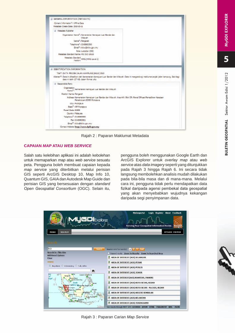
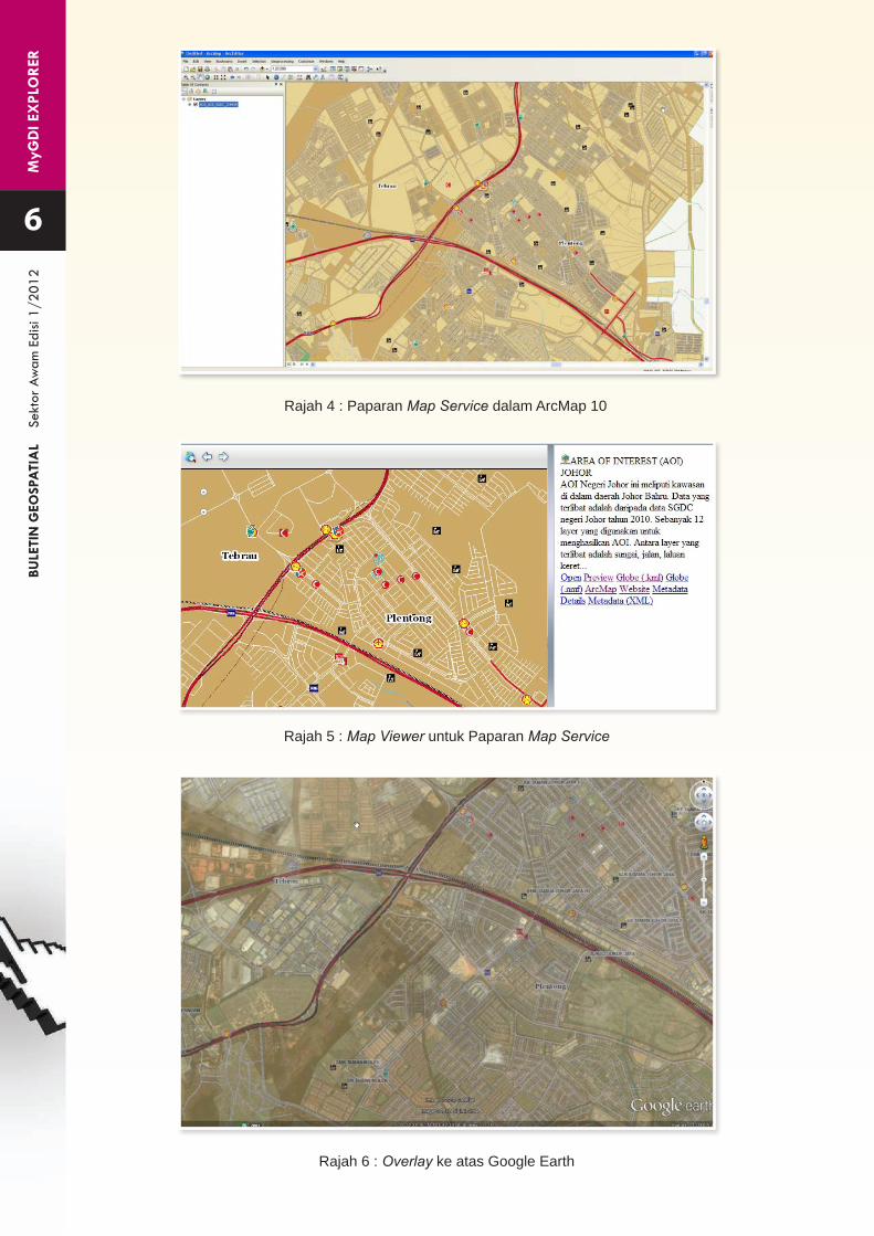
CAPAIAN MAP ATAU WEB SERVICE
Salah satu kelebihan aplikasi ini adalah kebolehan untuk memaparkan map atau web service sesuatu peta. Pengguna boleh membuat capaian kepada map service yang diterbitkan melalui perisian GIS seperti ArcGIS Desktop 10, Map Info 10, Quantum GIS, GAIA dan Autodesk Map Guide dan perisian GIS yang bersesuaian dengan standard Open Geospatial Consortium (OGC). Selain itu,
pengguna boleh menggunakan Google Earth dan ArcGIS Explorer untuk overlay map atau web service atas data imagery seperti yang ditunjukkan pada Rajah 3 hingga Rajah 6. Ini secara tidak langsung membolehkan analisis mudah dilakukan pada bila-bila masa dan di mana-mana. Melalui cara ini, pengguna tidak perlu mendapatkan data fizikal daripada agensi pembekal data geospatial yang akan menyebabkan wujudnya kekangan daripada segi penyimpanan data.
Rajah 3 : Paparan Carian Map Service
MyG
DI E
XPL
OR
ERBU
LETI
N G
EOSP
ATI
AL
Se
ktor
Aw
am E
disi
1/20
12
6
Rajah 5 : Map Viewer untuk Paparan Map Service
Rajah 6 : Overlay ke atas Google Earth
Rajah 4 : Paparan Map Service dalam ArcMap 10
MyG
DI E
XPL
OR
ERBU
LETI
N G
EOSP
ATI
AL
Se
ktor
Aw
am E
disi
1/20
12
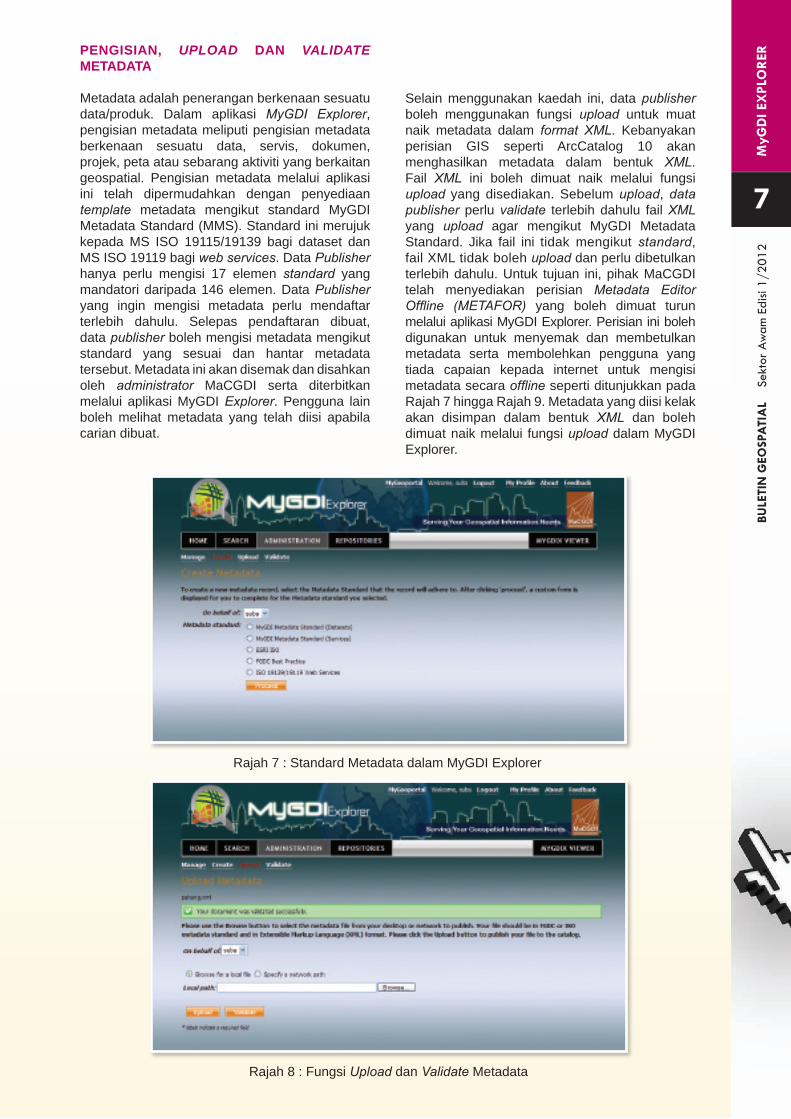
PENGISIAN, UPLOAD DAN VALIDATE METADATA
Metadata adalah penerangan berkenaan sesuatu data/produk. Dalam aplikasi MyGDI Explorer, pengisian metadata meliputi pengisian metadata berkenaan sesuatu data, servis, dokumen, projek, peta atau sebarang aktiviti yang berkaitan geospatial. Pengisian metadata melalui aplikasi ini telah dipermudahkan dengan penyediaan template metadata mengikut standard MyGDI Metadata Standard (MMS). Standard ini merujuk kepada MS ISO 19115/19139 bagi dataset dan MS ISO 19119 bagi web services. Data Publisher hanya perlu mengisi 17 elemen standard yang mandatori daripada 146 elemen. Data Publisher yang ingin mengisi metadata perlu mendaftar terlebih dahulu. Selepas pendaftaran dibuat, data publisher boleh mengisi metadata mengikut standard yang sesuai dan hantar metadata tersebut. Metadata ini akan disemak dan disahkan oleh administrator MaCGDI serta diterbitkan melalui aplikasi MyGDI Explorer. Pengguna lain boleh melihat metadata yang telah diisi apabila carian dibuat.
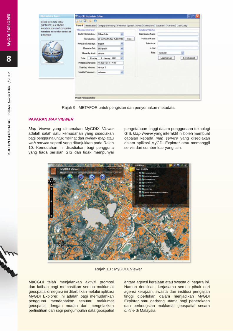
Selain menggunakan kaedah ini, data publisher boleh menggunakan fungsi upload untuk muat naik metadata dalam format XML. Kebanyakan perisian GIS seperti ArcCatalog 10 akan menghasilkan metadata dalam bentuk XML. Fail XML ini boleh dimuat naik melalui fungsi upload yang disediakan. Sebelum upload, data publisher perlu validate terlebih dahulu fail XML yang upload agar mengikut MyGDI Metadata Standard. Jika fail ini tidak mengikut standard, fail XML tidak boleh upload dan perlu dibetulkan terlebih dahulu. Untuk tujuan ini, pihak MaCGDI telah menyediakan perisian Metadata Editor Offline (METAFOR) yang boleh dimuat turun melalui aplikasi MyGDI Explorer. Perisian ini boleh digunakan untuk menyemak dan membetulkan metadata serta membolehkan pengguna yang tiada capaian kepada internet untuk mengisi metadata secara offline seperti ditunjukkan pada Rajah 7 hingga Rajah 9. Metadata yang diisi kelak akan disimpan dalam bentuk XML dan boleh dimuat naik melalui fungsi upload dalam MyGDI Explorer.
7
Rajah 7 : Standard Metadata dalam MyGDI Explorer
Rajah 8 : Fungsi Upload dan Validate Metadata
MyG
DI E
XPL
OR
ERBU
LETI
N G
EOSP
ATI
AL
Se
ktor
Aw
am E
disi
1/20
12
Rajah 9 : METAFOR untuk pengisian dan penyemakan metadata
8
Rajah 10 : MyGDIX Viewer
PAPARAN MAP VIEWER
Map Viewer yang dinamakan MyGDIX Viewer adalah salah satu kemudahan yang disediakan bagi pengguna untuk melihat dan overlay map atau web service seperti yang ditunjukkan pada Rajah 10. Kemudahan ini disediakan bagi pengguna yang tiada perisian GIS dan tidak mempunyai
MaCGDI telah menjalankan aktiviti promosi dan latihan bagi memastikan semua maklumat geospatial di negara ini diterbitkan melalui aplikasi MyGDI Explorer. Ini adalah bagi memudahkan pengguna mendapatkan sesuatu maklumat geospatial dengan mudah dan mengelakkan pertindihan dari segi pengumpulan data geospatial
pengetahuan tinggi dalam penggunaan teknologi GIS. Map Viewer yang interaktif ini boleh membuat capaian kepada map service yang disediakan dalam aplikasi MyGDI Explorer atau memanggil servis dari sumber luar yang lain.
antara agensi kerajaan atau swasta di negara ini. Namun demikian, kerjasama semua pihak dari agensi kerajaan, swasta dan institusi pengajian tinggi diperlukan dalam menjadikan MyGDI Explorer satu gerbang utama bagi penerokaan dan perkongsian maklumat geospatial secara online di Malaysia.
PEN
GH
ASI
LAN
C
URV
E N
UM
BER
BULE
TIN
GEO
SPA
TIA
L
Sekt
or A
wam
Edi
si 1/
2012
9
Abstrak
Kertas kerja ini merumuskan pengaplikasian teknik Sistem Maklumat Geografi (GIS) dan Penderiaan Jauh (Remote Sensing) dalam pemprosesan dan analisis data bagi kajian hidrologi di Kota Damansara, Selangor yang merupakan sebuah kawasan perumahan yang bersaiz sekitar 428 hektar. Jenis guna tanah utama di kawasan kajian terdiri daripada kawasan perumahan dan rumah kedai yang telah menyumbang separuh daripada keseluruhan saiz kawasan tadahan. Jenis guna tanah yang lain merangkumi kawasan hutan simpan, sekolah, kawasan landskap dan padang. Tujuan kajian ini adalah untuk memperolehi Curve Number (CN) iaitu satu parameter penting dalam kajian hidrologi yang menggunakan Kaedah United States Soil Conservation Service Curve Number
(SCS CN) untuk setiap sub-kawasan tadahan melalui integrasi data-data seperti guna tanah, kumpulan hidrologi tanah dan kawasan tadahan dengan menggunakan teknik GIS. Teknik GIS berupaya mempercepatkan pemprosesan data serta memudahkan proses analisis data dan sememangnya ia amat berguna dalam bidang penyelidikan dan pembangunan.
Kata Kunci
Sistem Maklumat Geografi, Penderiaan Jauh, Curve Number
Disediakan oleh:Y.S. LiewPusat Kajian SungaiInstitut Penyelidikan Hidraulik Kebangsaan MalaysiaKementerian Sumber Asli dan Alam [email protected]: 03-89382470Faks: 03-89382469
Kertas kerja dalam versi Bahasa Inggeris telah dibentangkan di persidangan “9th International Conference on Hydroinformatics” di Tian Jin China (7-11 September 2010)
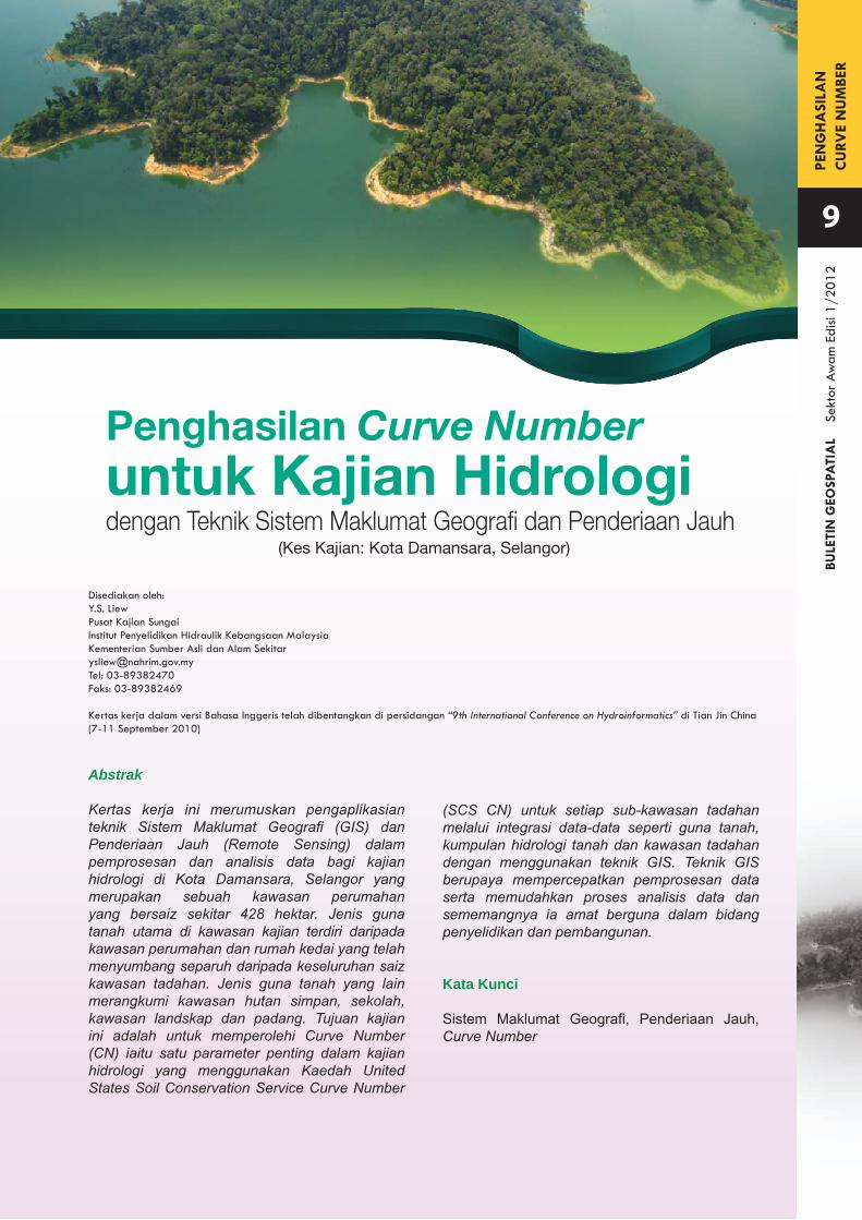
Penghasilan Curve Number
dengan Teknik Sistem Maklumat Geografi dan Penderiaan Jauhuntuk Kajian Hidrologi
(Kes Kajian: Kota Damansara, Selangor)
PEN
GH
ASI
LAN
C
URV
E N
UM
BER
BULE
TIN
GEO
SPA
TIA
L
Sekt
or A
wam
Edi
si 1/
2012
PENGENALAN
Projek penyelidikan dan pembangunan dalam bidang sumber air amat bergantung kepada perancangan yang rapi termasuklah proses pengumpulan data sehingga projek dilaksanakan dan beroperasi. Kebanyakan projek penyelidikan dalam bidang sumber air sama ada untuk tujuan perancangan atau reka bentuk terperinci, pengumpulan data merupakan satu proses yang penting dan kualiti data yang dikumpulkan akan menyumbang kepada kualiti hasil dan keputusan kajian tersebut. Seth et al. (2006) menyatakan bahawa penggunaan teknik GIS dalam pengumpulan data sesuatu kawasan kajian amat berfaedah. Lanjutan daripada pembangunan Teknologi Maklumat dan Komunikasi yang semakin pesat, teknik GIS juga digunakan secara meluas untuk menyimpan, memproses, mengurus dan memaparkan sesuatu data. Justeru itu, pengaplikasian teknik GIS dan penderiaan jauh perlu digunakan secara efektif untuk menggantikan kaedah pemprosesan yang
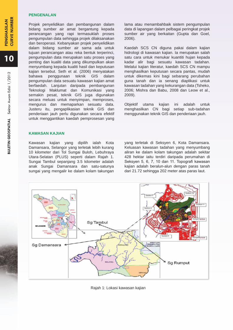
KAWASAN KAJIAN
Kawasan kajian yang dipilih ialah Kota Damansara, Selangor yang terletak lebih kurang 10 kilometer dari Tol Sungai Buloh, Lebuhraya Utara-Selatan (PLUS) seperti dalam Rajah 1. Sungai Tambul sepanjang 3.5 kilometer adalah anak Sungai Damansara dan satu-satunya sungai yang mengalir ke dalam kolam takungan
lama atau menambahbaik sistem pengumpulan data di lapangan dalam pelbagai peringkat projek sumber air yang berkaitan (Gupta dan Goel, 2006).
Kaedah SCS CN diguna pakai dalam kajian hidrologi di kawasan kajian. Ia merupakan salah satu cara untuk menukar kuantiti hujan kepada kadar alir bagi sesuatu kawasan tadahan. Melalui kajian literatur, kaedah SCS CN mampu menghasilkan keputusan secara pantas, mudah untuk dikemas kini bagi sebarang perubahan guna tanah dan ia senang diaplikasi untuk kawasan tadahan yang kekurangan data (Tsheko, 2006; Mishra dan Babu, 2008 dan Leow et al., 2009).
Objektif utama kajian ini adalah untuk menghasilkan CN bagi setiap sub-tadahan menggunakan teknik GIS dan penderiaan jauh.
Rajah 1: Lokasi kawasan kajian
10
yang terletak di Seksyen 6, Kota Damansara. Keluasan kawasan tadahan yang menyumbang aliran ke dalam kolam takungan adalah sekitar 428 hektar iaitu terdiri daripada perumahan di Seksyen 5, 6, 7, 10 dan 11. Topografi kawasan kajian adalah beralun-alun dengan paras tanah dari 21.72 sehingga 202 meter atas paras laut.
PEN
GH
ASI
LAN
C
URV
E N
UM
BER
BULE
TIN
GEO
SPA
TIA
L
Sekt
or A
wam
Edi
si 1/
2012
11
METODOLOGI
Pengumpulan Data
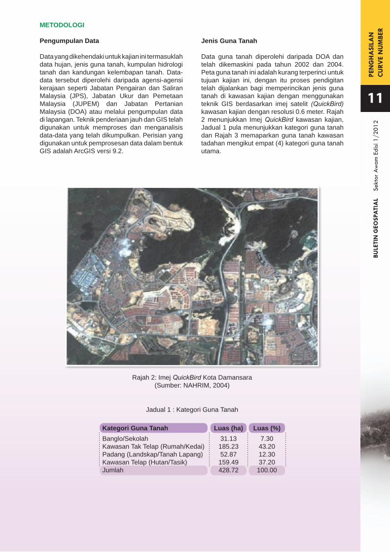
Data yang dikehendaki untuk kajian ini termasuklah data hujan, jenis guna tanah, kumpulan hidrologi tanah dan kandungan kelembapan tanah. Data-data tersebut diperolehi daripada agensi-agensi kerajaan seperti Jabatan Pengairan dan Saliran Malaysia (JPS), Jabatan Ukur dan Pemetaan Malaysia (JUPEM) dan Jabatan Pertanian Malaysia (DOA) atau melalui pengumpulan data di lapangan. Teknik penderiaan jauh dan GIS telah digunakan untuk memproses dan menganalisis data-data yang telah dikumpulkan. Perisian yang digunakan untuk pemprosesan data dalam bentuk GIS adalah ArcGIS versi 9.2.
Rajah 2: Imej QuickBird Kota Damansara(Sumber: NAHRIM, 2004)
Jadual 1 : Kategori Guna Tanah
Banglo/SekolahKawasan Tak Telap (Rumah/Kedai)Padang (Landskap/Tanah Lapang)Kawasan Telap (Hutan/Tasik)Jumlah
Kategori Guna Tanah31.13185.2352.87159.49428.72
Luas (ha)7.3043.2012.3037.20100.00
Luas (%)
Jenis Guna Tanah
Data guna tanah diperolehi daripada DOA dan telah dikemaskini pada tahun 2002 dan 2004. Peta guna tanah ini adalah kurang terperinci untuk tujuan kajian ini, dengan itu proses pendigitan telah dijalankan bagi memperincikan jenis guna tanah di kawasan kajian dengan menggunakan teknik GIS berdasarkan imej satelit (QuickBird) kawasan kajian dengan resolusi 0.6 meter. Rajah 2 menunjukkan Imej QuickBird kawasan kajian, Jadual 1 pula menunjukkan kategori guna tanah dan Rajah 3 memaparkan guna tanah kawasan tadahan mengikut empat (4) kategori guna tanah utama.

PEN
GH
ASI
LAN
C
URV
E N
UM
BER
BULE
TIN
GEO
SPA
TIA
L
Sekt
or A
wam
Edi
si 1/
2012
Rajah 4: Peta Kumpulan Hidrologi Tanah(Sumber: DOA)
Rajah 3: Guna Tanah Kawasan Tadahan Mengikut Empat (4) Kategori Tanah Utama (Sumber: NAHRIM)
Kumpulan Hidrologi Tanah
Peta Kumpulan Hidrologi Tanah diperolehi daripada DOA, Putrajaya. Rajah 4 menunjukkan dua kumpulan hidrologi tanah untuk kawasan kajian iaitu - Telemong-Akob-Alluvium Tempatan yang dikategorikan dalam Kumpulan Hidrologi Tanah A & C, manakala Renggam-Jeranggau dikategorikan dalam Kumpulan Hidrologi Tanah B.
12
PEN
GH
ASI
LAN
C
URV
E N
UM
BER
BULE
TIN
GEO
SPA
TIA
L
Sekt
or A
wam
Edi
si 1/
2012
13
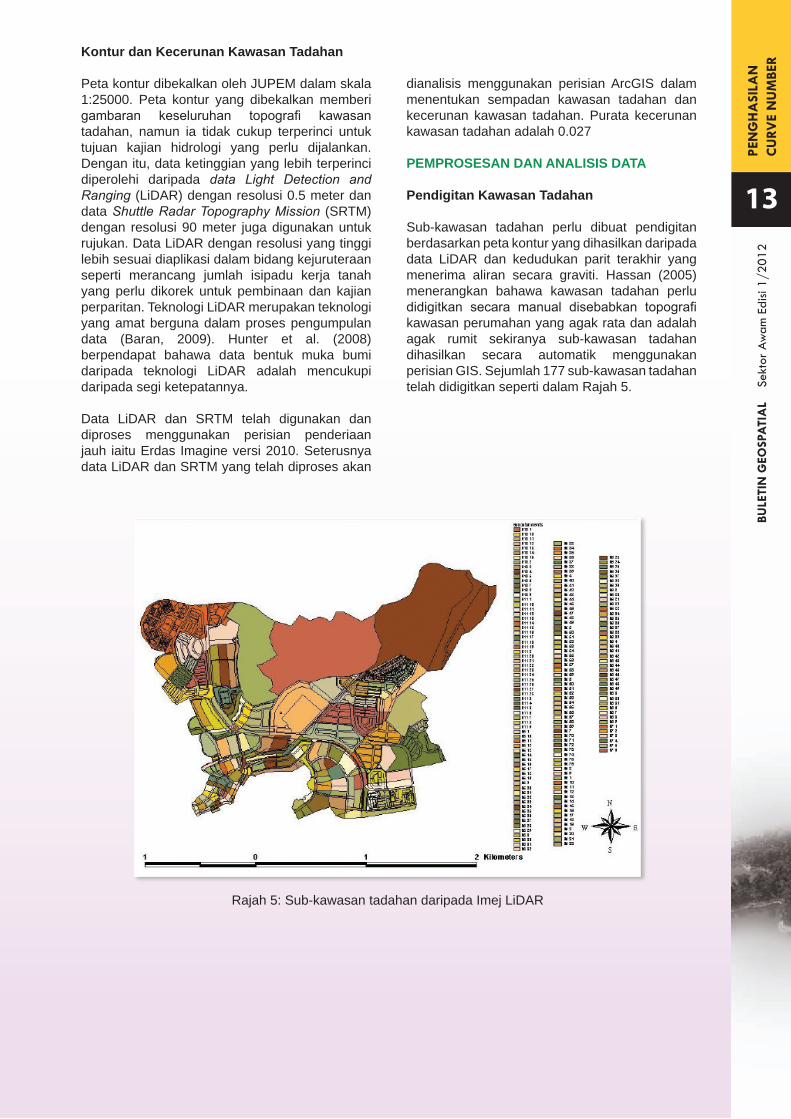
Rajah 5: Sub-kawasan tadahan daripada Imej LiDAR
Kontur dan Kecerunan Kawasan Tadahan
Peta kontur dibekalkan oleh JUPEM dalam skala 1:25000. Peta kontur yang dibekalkan memberi gambaran keseluruhan topografi kawasan tadahan, namun ia tidak cukup terperinci untuk tujuan kajian hidrologi yang perlu dijalankan. Dengan itu, data ketinggian yang lebih terperinci diperolehi daripada data Light Detection and Ranging (LiDAR) dengan resolusi 0.5 meter dan data Shuttle Radar Topography Mission (SRTM) dengan resolusi 90 meter juga digunakan untuk rujukan. Data LiDAR dengan resolusi yang tinggi lebih sesuai diaplikasi dalam bidang kejuruteraan seperti merancang jumlah isipadu kerja tanah yang perlu dikorek untuk pembinaan dan kajian perparitan. Teknologi LiDAR merupakan teknologi yang amat berguna dalam proses pengumpulan data (Baran, 2009). Hunter et al. (2008) berpendapat bahawa data bentuk muka bumi daripada teknologi LiDAR adalah mencukupi daripada segi ketepatannya.
Data LiDAR dan SRTM telah digunakan dan diproses menggunakan perisian penderiaan jauh iaitu Erdas Imagine versi 2010. Seterusnya data LiDAR dan SRTM yang telah diproses akan
dianalisis menggunakan perisian ArcGIS dalam menentukan sempadan kawasan tadahan dan kecerunan kawasan tadahan. Purata kecerunan kawasan tadahan adalah 0.027
PEMPROSESAN DAN ANALISIS DATA
Pendigitan Kawasan Tadahan
Sub-kawasan tadahan perlu dibuat pendigitan berdasarkan peta kontur yang dihasilkan daripada data LiDAR dan kedudukan parit terakhir yang menerima aliran secara graviti. Hassan (2005) menerangkan bahawa kawasan tadahan perlu didigitkan secara manual disebabkan topografi kawasan perumahan yang agak rata dan adalah agak rumit sekiranya sub-kawasan tadahan dihasilkan secara automatik menggunakan perisian GIS. Sejumlah 177 sub-kawasan tadahan telah didigitkan seperti dalam Rajah 5.
PEN
GH
ASI
LAN
C
URV
E N
UM
BER
BULE
TIN
GEO
SPA
TIA
L
Sekt
or A
wam
Edi
si 1/
2012
HASIL DAN PERBINCANGAN
Penentuan Curve Number Menggunakan Kaedah GIS
Kaedah SCS-CN telah dikenal pasti sebagai kaedah untuk menganggarkan kadar alir daripada kawasan tadahan yang mempunyai data yang tidak mencukupi (Yip, 2002; Tsheko, 2006; Kannan et al., 2006 dan Leow et al., 2009). CN dihasilkan menggunakan kaedah penderiaan jauh dan teknik GIS seperti yang dicadangkan oleh Mishra and Babu (2008).
Pertama, imej QuickBird kawasan kajian (Rajah 2) perlu didigitkan untuk mendapatkan peta guna tanah menggunakan perisian GIS (Rajah 3). Selepas itu, sub-kawasan tadahan seperti dalam Rajah 5 didigitkan berdasarkan peta kontur yang dihasilkan daripada data LiDAR dan kedudukan parit yang menjadikan tempat terendah untuk aliran dari setiap sub-tadahan.
Peta guna tanah yang telah didigitkan dan lapisan sub-tadahan akan digabungkan menggunakan Geoprocessing Wizard dalam aplikasi GIS. Ia
KeadaanTanahAMC I
AMC II
AMC III
KumpulanHidrologi Tanah
ABCDABCDABCD
Banglo/Sekolah39.6555.7567.2273.7661.0075.0083.0087.0078.2587.3491.8293.9
Kawasan Tak Telap (Rumah/ Kedai)
77.2682.8586.8188.8689.0092.0094.0095.0094.9096.3697.397.76
Padang (Landskap/ Tanah Lapang)
21.1739.6554.4562.6939.0061.0074.0080.0059.5278.2586.7590.2
Kawasan Telap (Hutan/Tasik)
12.2833.9249.4958.4425.0055.0070.0077.0043.4073.7684.2988.51
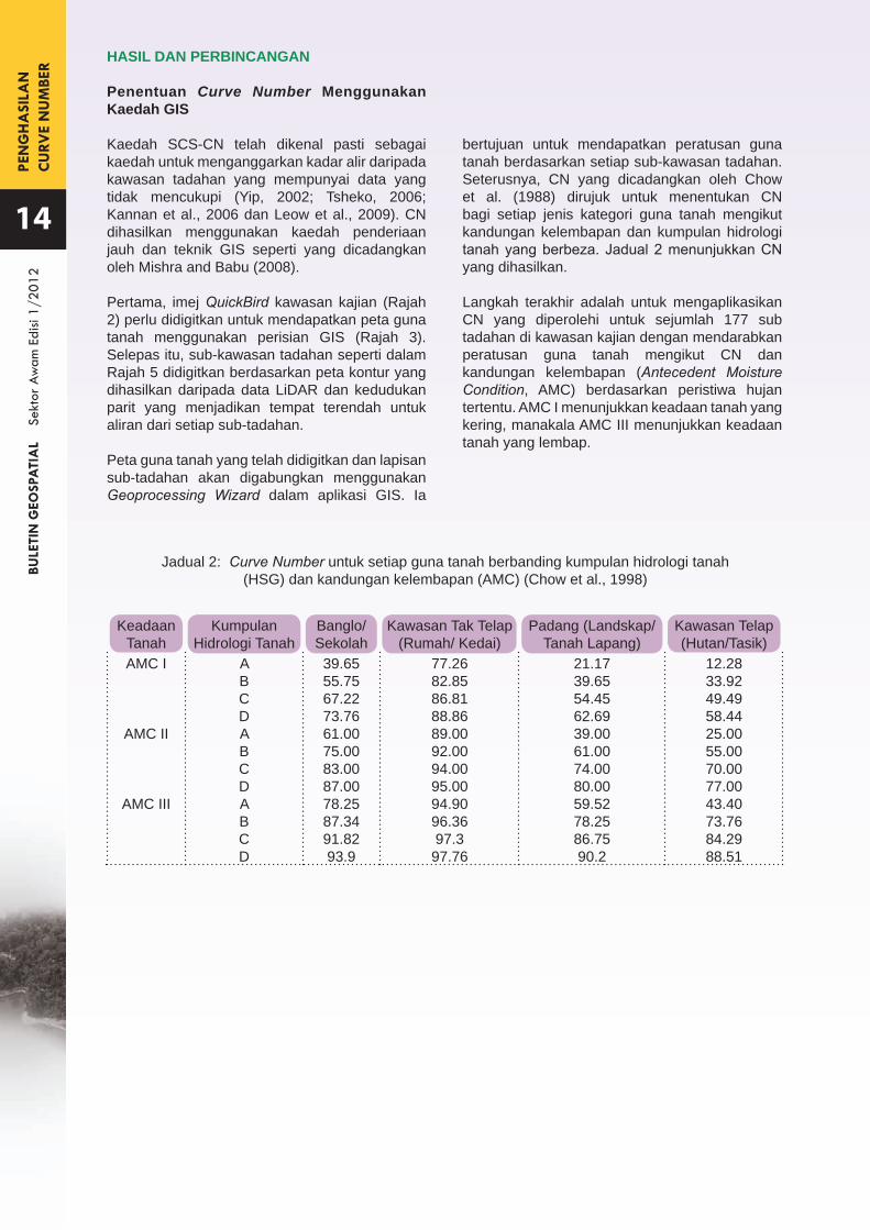
bertujuan untuk mendapatkan peratusan guna tanah berdasarkan setiap sub-kawasan tadahan. Seterusnya, CN yang dicadangkan oleh Chow et al. (1988) dirujuk untuk menentukan CN bagi setiap jenis kategori guna tanah mengikut kandungan kelembapan dan kumpulan hidrologi tanah yang berbeza. Jadual 2 menunjukkan CN yang dihasilkan.
Langkah terakhir adalah untuk mengaplikasikan CN yang diperolehi untuk sejumlah 177 sub tadahan di kawasan kajian dengan mendarabkan peratusan guna tanah mengikut CN dan kandungan kelembapan (Antecedent Moisture Condition, AMC) berdasarkan peristiwa hujan tertentu. AMC I menunjukkan keadaan tanah yang kering, manakala AMC III menunjukkan keadaan tanah yang lembap.
Jadual 2: Curve Number untuk setiap guna tanah berbanding kumpulan hidrologi tanah (HSG) dan kandungan kelembapan (AMC) (Chow et al., 1998)
14
PEN
GH
ASI
LAN
C
URV
E N
UM
BER
BULE
TIN
GEO
SPA
TIA
L
Sekt
or A
wam
Edi
si 1/
2012
15
KESIMPULAN
Penggunaan teknik GIS dan penderiaan jauh dalam kajian ini berjaya membantu dalam penghasilan parameter CN untuk digunakan dalam model SCS. Ia menjimatkan masa dan kos dalam pelbagai peringkat pemprosesan data. Justeru itu, kaedah GIS dan penderiaan jauh dicadangkan untuk penggunaan yang lebih meluas seperti menyimpan, memproses, menganalisis, mengurus dan memaparkan data-data dengan lebih sistematik dan berkesan bagi tujuan projek penyelidikan dan pembangunan di dalam bidang sumber air.
PENGHARGAAN
Setinggi-tinggi penghargaan diucapkan kepada NAHRIM atas peruntukan yang disalurkan di bawah peruntukan Rancangan Malaysia Ke-9 bagi melaksanakan projek ini. Jutaan terima kasih juga ditujukan kepada semua rakan sekerja yang terlibat secara langsung atau tidak langsung dalam bersama-sama menjayakan kajian ini.
RUJUKAN
Baran, I. (2009). Technology of Cross Hair. The Global Geospatial Magazine: GIS Development. India: GIS Development Pvt. Ltd. 13(6). Pp. 47.Chow, V.T., Maidment, D.R. dan Mays, L.W. (1988). Applied Hydrology. Singapore: McGraw-Hill. Pp. 2-3, 108, 147-151, 213-214 dan 385-388.Gupta, S.C. dan Goel, R. S. (2006). Application of GIS and Remote Sensing Techniques in Water Resources Development. Abstrak daripada GIS Development Web.
Hassan, J. (2005). River and Floodplain Modelling for the Development of Flood Risk Map: A Case Study of Sungai Selangor. Tesis Master. Universiti Sains Malaysia.
Hunter, N. M., Bates, P.D., Neelz, S., Pender, G., Villanueva, I., Wright, N. G., Liang, D., Falconer, R.A., Lin, B., Waller, S., Crossley, A. J. dan Mason, D.C. (2008). Benchmarking 2D Hydraulic Models for Urban Flooding. Proceeding of the Institution of Civil Engineers. Water Management. (161) 2008. Pp. 13-30.
Kannan, N., White, S.N., Worrall, F. dan Whelan, M.J. (2006). Hydrological Modeling of a Small Catchment using SWAT-2000 – Ensuring Correct Flow Partitioning for Contaminant Modelling. Journal of Hydrology. (2006). Pp. 64-72.
Leow, C.S., Abdullah, R., Zakaria, N.A., Ab. Ghani, A. dan Chang, C.K. (2009). Modelling Urban River Catchment: A Case Study in Malaysia. Proceeding of the Institution of Civil Engineers. Water Management. (162) 2009. Pp. 27-36.
Mishra, P. dan Babu, R. R. (2008). Estimation of Runoff from Agriculture Watershed in Eastern India Using Remote Sensing and Geographic Information System (GIS).
Seth, I., Soonthornnonda, P. dan Christensen, E. R. (2006). Use of GIS in Urban Storm-Water Modelling. Journal of Environmetal Engineering. December. Pp. 1550-1552.
Tsheko, R. (2006). Comparison between the United States Soil Conservation Service (SCS) and the Two Models Commonly Used for Estimating Rainfall-Runoff in South-Eastern Botswana. Water Research Commission. South Africa. 32(2006). Pp. 26-36.
Yip, H.W. (2002). Flood Runoff Estimation of Ungaged River Catchments using Soil Conservation Service Method. Tesis Master. Universiti Sains Malaysia.

SPA
CE
IND
UST
RYBU
LETI
N G
EOSP
ATI
AL
Se
ktor
Aw
am E
disi
1/20
12
SPACE INDUSTRYDEVELOPMENT FOR THE NATION
ABSTRACT
Space industry has been established since the launch of Sputnik into space in 1957. Today, space utilization ranges from traditional space industries such as satellite manufacturing and launch services to more on the downstream industries. These downstream industries represent a huge segment of the space business. For a developing nation who has an ambition to venture into traditional space industry, it is difficult to give an impact to the upstream space industries. The established players from the well-known agencies and countries will certainly dominate the market and be the main choice of all of the associated segment development. Most of the nations invested in space partly for the pride associated with the technological advances that participation in space requires. As a result, the development of the downstream space industries will almost be a certain answer for a developing country in order to join the elite club of space venturers. With an already solid and stable base of manufacturing industries, added with strong research and development backing by its government, a developing nation can one day relish the fruits from the space industry by providing the fusion of downstream space products and services.
Keywords: space industry, space applications, downstream sector, policy
Sr. Shahrizal IdeResearch OfficerSpace Application and Technology Development DivisionNational Space Agency (ANGKASA)Ministry of Science, Technology and Innovation (MOSTI)
Friday, 4th of October 1957, the Soviet Union successfully launched Sputnik I. The world’s first artificial satellite was about the size of a basketball, weighed only 84 kilograms, and took about 98 minutes to orbit the Earth on its elliptical path. That launch ushered in new political, military, technological, and scientific developments.
The space industry has received some hundreds of billions of government investment in total. With the technology it brings, millions of mankind on earth is benefiting the outcome of the hard work of space engineers and researchers. In fact, no other technology or scientific breakthroughs has brought more benefits to our everyday lives then the space technology. Space investment indeed has produced assistances directly in the form of telecommunications and remote sensing capabilities and indirectly in the form of technological spin-offs, national prestige and scientific knowledge. Weather, telecommunications, environmental analyses, spatial development and national security are examples of the space technologies upon which humankind relies.
Perhaps the most important technology from space is the many satellites orbiting the earth today. The world telecommunication network backbone depends heavily on the communication satellites to deliver information. Even the backbone of internet is carried on the satellites nowadays. Without these satellites, the mobile
16
SPA
CE
IND
UST
RYBU
LETI
N G
EOSP
ATI
AL
Se
ktor
Aw
am E
disi
1/20
12
17
phone we carry around everywhere, the satellite phone used on ships and the fax machine will be useless really soon. Also with the many communication satellites circling the earth today, we are able to watch hundreds or even thousands of TV stations. In addition on that, we can also watch live TV of any important event anywhere in the world.
GPS or Global Positioning System device can help you determine exactly where you are at any given moment. Not only can a GPS give you the name of the street you might be traveling on, but GPS systems can also give you the exact latitude and longitude of where you are located. GPS technology has developed into a resource that goes far beyond its original goals of navigation and location determination. People with different jobs from many industries are using GPS in ways that make their work more productive, safer and often easier. These days, GPS is finding its way into cars, boats, planes, construction equipment, moviemaking gear, farm machinery and even laptop computers. Scientists, cartographers, postmen, forestry workers, mineral exploration, soldiers, pilots, surveyors, hikers, delivery drivers, sailors, dispatchers, fire fighters, wildlife habitation managers and many others are using GPS as a part of their regular work tools.
Whoever has imagined seeing their house or office or even their car parked in front of the house from space in form of a picture? With the introduction of remote sensing satellite, all those unthinkable things we only imagine to see from space are all now available through the internet. Remote sensing satellites which are orbiting in low earth orbit have revolutionized the way mankind look on the earth spatial attributes. Apart from the original purpose which is for military and security reasons, the application is now used for a variety of ways. Mapping, town planning and agriculture are the main application these images are used. Since
the aftermath of the historical Asia Pacific tsunami in 2003, disaster management is an essential part of the application of remote sensing. The Japan tsunami 2011, earth observation images integrated with Geographic Information System (GIS) clearly help in managing and coordinating the crucial assistance by the Japanese government to the affected areas. Nowadays, business folks have seen the satellite images as an essential tool for developing their business by performing spatial analysis of the potential market, and of course by posting their business location on Google Maps.
The space industry consists of a fairly well defined set of core elements; launch, satellite, and control which are supporting a wide range of users, including commercial, civil, government, and military customers. For the past two years, the space industry has had global revenues totalling over $250 billion, of which government expenditures represented 31 percent, with the remainder consisting of commercial goods and services. The $175 billion commercial system revenue stream is roughly split 97 percent into services value system, 2 percent into satellites, and 1 percent for launch. Within the $170 billion services sector, commercial satellite operations infrastructure represented nearly 20 percent of total revenue. This infrastructure is comprised of terminals, satellite control ground stations, terrestrial network infrastructure, and other terrestrial based elements.
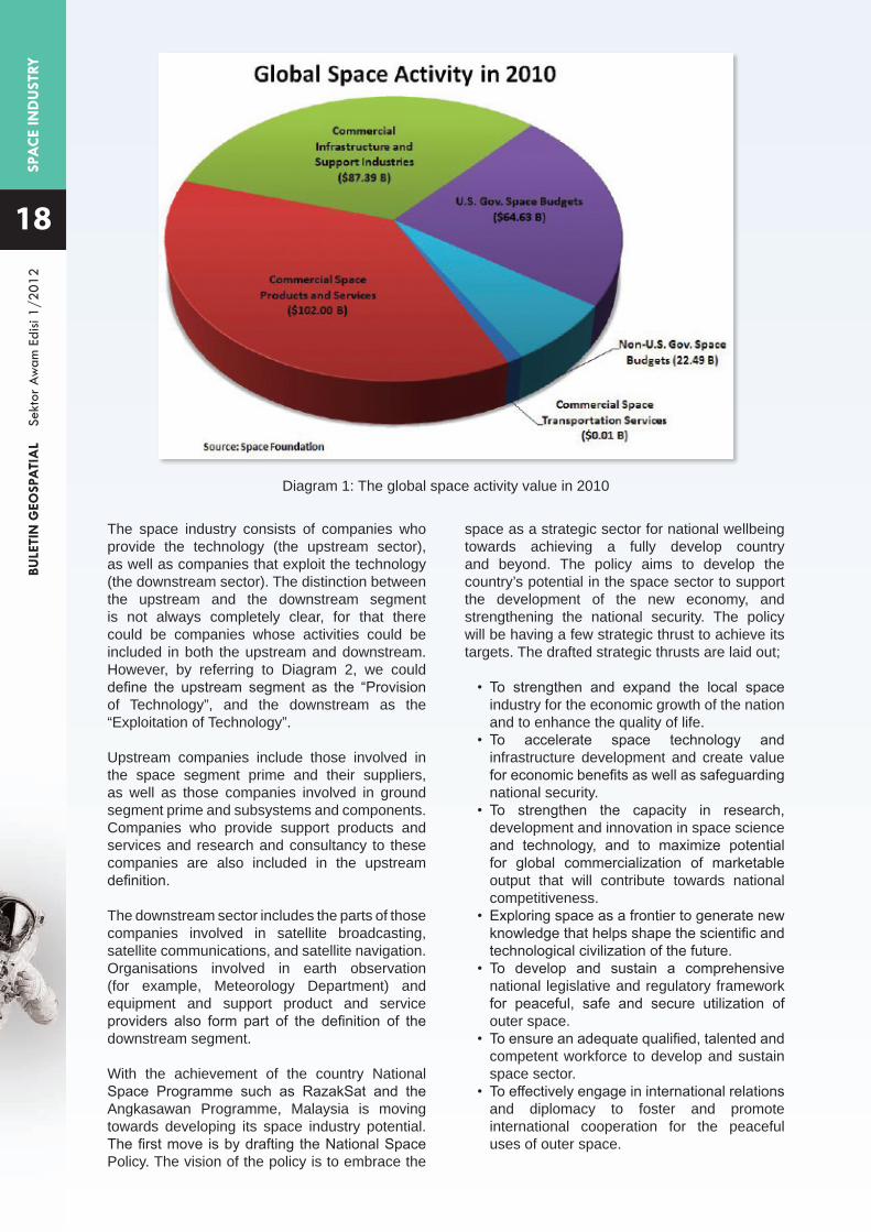
In the year of 2010, as the global economy recovered from a recession, the space industry has maintained its growth. It has been fifth year in a row the space economy showed tremendous growth. The space economy increased by 7.7 percent in 2010, accelerating from annual growth rates of approximately 5 percent that were observed in 2008 and 2009. The space economy increased by nearly $20 billion during 2010, reaching an estimated total of $276.52 billion. Some of this growth came from increases in government spending, but the vast majority occurred in the commercial sector. More on global space activities in 2010 can be more explained in Diagram 1.
SPA
CE
IND
UST
RYBU
LETI
N G
EOSP
ATI
AL
Se
ktor
Aw
am E
disi
1/20
12
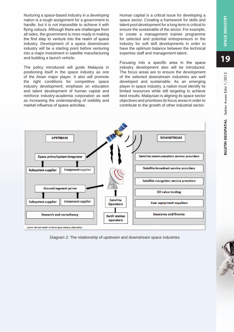
The space industry consists of companies who provide the technology (the upstream sector), as well as companies that exploit the technology (the downstream sector). The distinction between the upstream and the downstream segment is not always completely clear, for that there could be companies whose activities could be included in both the upstream and downstream. However, by referring to Diagram 2, we could define the upstream segment as the “Provision of Technology”, and the downstream as the “Exploitation of Technology”.
Upstream companies include those involved in the space segment prime and their suppliers, as well as those companies involved in ground segment prime and subsystems and components. Companies who provide support products and services and research and consultancy to these companies are also included in the upstream definition.
The downstream sector includes the parts of those companies involved in satellite broadcasting, satellite communications, and satellite navigation. Organisations involved in earth observation (for example, Meteorology Department) and equipment and support product and service providers also form part of the definition of the downstream segment.
With the achievement of the country National Space Programme such as RazakSat and the Angkasawan Programme, Malaysia is moving towards developing its space industry potential. The first move is by drafting the National Space Policy. The vision of the policy is to embrace the
18
Diagram 1: The global space activity value in 2010
space as a strategic sector for national wellbeing towards achieving a fully develop country and beyond. The policy aims to develop the country’s potential in the space sector to support the development of the new economy, and strengthening the national security. The policy will be having a few strategic thrust to achieve its targets. The drafted strategic thrusts are laid out;
• To strengthen and expand the local space industry for the economic growth of the nation and to enhance the quality of life.
• To accelerate space technology and infrastructure development and create value for economic benefits as well as safeguarding national security.
• To strengthen the capacity in research, development and innovation in space science and technology, and to maximize potential for global commercialization of marketable output that will contribute towards national competitiveness.
• Exploring space as a frontier to generate new knowledge that helps shape the scientific and technological civilization of the future.
• To develop and sustain a comprehensive national legislative and regulatory framework for peaceful, safe and secure utilization of outer space.
• To ensure an adequate qualified, talented and competent workforce to develop and sustain space sector.
• To effectively engage in international relations and diplomacy to foster and promote international cooperation for the peaceful uses of outer space.
SPA
CE
IND
UST
RYBU
LETI
N G
EOSP
ATI
AL
Se
ktor
Aw
am E
disi
1/20
12
19
Diagram 2: The relationship of upstream and downstream space industries
Nurturing a space-based industry in a developing nation is a tough assignment for a government to handle, but it is not impossible to achieve it with flying colours. Although there are challenges from all sides, the government is more ready in making the first step to venture into the realm of space industry. Development of a space downstream industry will be a starting point before venturing into a major investment in satellite manufacturing and building a launch vehicle.
The policy introduced will guide Malaysia in positioning itself in the space industry as one of the Asian major player. It also will promote the right conditions for competitive space industry development; emphasis on education and talent development of human capital and reinforce industry-academia corporation as well as increasing the understanding of visibility and market influence of space activities.
Human capital is a critical issue for developing a space sector. Creating a framework for skills and talent pool development for a long term is critical to ensure the sustainable of the sector. For example, to create a management trainee programme for selected and potential entrepreneurs in the industry for soft skill developments in order to have the optimum balance between the technical expertise staff and management talent.
Focusing into a specific area in the space industry development also will be introduced. The focus areas are to ensure the development of the selected downstream industries are well developed and sustainable. As an emerging player in space industry, a nation must identify its limited resources while still targeting to achieve best results. Malaysian is aligning its space sector objectives and prioritises its focus areas in order to contribute to the growth of other industrial sector.
A S
URV
EY R
ELA
TED
TO
3D
PRO
PERT
YBU
LETI
N G
EOSP
ATI
AL
Se
ktor
Aw
am E
disi
1/20
12
A SURVEY RELATED TO
ABSTRACT
A questionnaire survey was carried out on 114 personnel from government authorities and professional companies administering cadastre registration in Penang, Selangor, Kuala Lumpur, Putrajaya and Johore. The aim of the study was to elicit the opinions of the respondents and to appraise their understanding on five study areas, viz. land legislation, land administration, cadastre registration, cadastral survey and mapping issues. The respondents were from six main groups: State Lands and Mines Office, State District Land Office, Department of Survey and Mapping Malaysia, Department of Director General of Lands and Mines Office, State Local Authority (Valuation and Property Management Department and/or Town Planning and Development Department) and Licensed Land
Tan Liat Choon and Khadijah Binti Hussin
Seksyen Polisi dan Garis PanduanPusat Infrastruktur Data Geospatial Negara (MaCGDI)Kementerian Sumber Asli dan Alam SekitarAras 7 & 8, Wisma Sumber AsliNo.25, Persiaran Perdana, Presint 462574 Putrajaya
Land Administration and Development DepartmentFaculty of Geoinformation and Real EstateUniversiti Teknologi Malaysia81310 Skudai, Johor, Malaysia
Surveyors. From the present survey, the majority (57.5 %) of the respondents felt that the current land laws failed to define 3D property rights clearly. A high number (83.9%) of respondents thought that new legislation which integrated 3D aspects in cadastre registration, survey and mapping issues would address this anomaly. It is timely that a Cadastral System and Land Registration System that caters to the needs of 3D properties and property rights are instituted in Malaysia.
Keywords: land administration, 3D property rights, legislation, cadastre, cadastral survey
3D PROPERTY IN MALAYSIA
20

A S
URV
EY R
ELA
TED
TO
3D
PRO
PERT
YBU
LETI
N G
EOSP
ATI
AL
Se
ktor
Aw
am E
disi
1/20
12
21
INTRODUCTION
Forrai and Kirschner (2002) observed that the availability of land use for future and further construction would be both expensive and limited. As the demand and competition for space on the two-dimensional land surface intensifies, the third dimension in property formation assumes increasing importance. In recent times, this third vertical dimension is seen to play a significant role in determining the rights of real property, especially in areas with multi-level mixed development. One of the important issues with regard to real property is the inadequacy of vacant land for rapid development. Many countries, including Malaysia, do not have enough vacant land on the ground surface to cater for the rapid development. This is particularly true in big cities that see increasing numbers of mixed settlements amidst modern skyscrapers.
Present cadastral mapping is moving towards a system whereby real property can be manipulated, processed, and managed in a 3D environment. This mapping system that is being contemplated in Malaysia provides vital information, including location and ownership for real properties. Whereas the current cadastral information serves present needs, there will be a time when the currently compiled information can no longer cater to more advanced and complex situations that result from innovative developments of the big city. What will inevitably be needed, therefore, is a more advanced system that incorporates suitable legislative and technical solutions in parallel with the implementation of 3D property rights.
PROBLEMS AND CONSTRAINTS
In Malaysia, there is a lack of proper legislation regarding 3D property in land and cadastral law to cater for the registration of any related legal and technical aspects. Many conflicts seem to exist between laws and statutes with the current cadastral status. Therefore, the rights associated with this registration should be clear in the registry titles issued. For example, Strata Title Act 1985 (Act 318) & Rules and Order allows land to be subdivided into parcels or land parcels based on the area occupied, and National Land Code 1965 (Act 56 of 1965) & Regulations allow air space rights above ground surface up to a maximum of 21 years in form ranging from an absolute conveyance to splitting off individual rights associated with the air space parcel. This is always used in a complication urban multi-level mix development, or in the allocation of property rights concerning underground facilities in large urban areas (Mitrofanova, 2002).
There are currently many arguments about the surface under different categories of land use, subdivision, partition and amalgamation; these arguments would evidently be different if 3D
property rights are used. Without the possibility of using 3D properties, other legal rights have to be used to allow separate parties to use different parts of one building or property. To make such rights possible, different and new legal institutions have to be created, such as mineral and air rights (Sandberg, 2003). Again, 3D property rights can take on different forms and can vary from full ownership to rights of different extents (Paulsson, 2007).
In conclusion, there are many aspects to consider in implementing the 3D property rights of a legal and technical nature. Among these aspects, the core of this research attempt to investigate problems occurs in the Malaysia cadastral system on the legal aspect which can be seen as a foundation for 3D property and its technical aspect. The main legal documents involved are National Land Code 1965 (Act 56 of 1965) & Regulations; Strata Title Act 1985 (Act 318) & Rules and Order; and Building and Common Property (Maintenance and Management) Act 2007 (Act 663). Without proper land and cadastral legislation, such property cannot be formed at all. As a result of this, it has also been necessary to look into the legal systems of other countries, where 3D property formation is already possible by law, and to gain information about what kind of problems are faced there and how they have handled; this is so as to better understand the problems that may occur for countries introducing 3D property rights into their legislation.
RESEARCH HYPOTHESIS
The hypothesis is that - what contents in general, in the relevant legal documents, documents of title and documents of strata title, certified plan and certified strata plan have to be amended or in order to translate the legal expression from traditional cadastral practice to future cadastral practice for 3D property - whether a new legislation should be introduced or only amend the present legislation where type of provisions in the new 3D property rights’ regulations and practices are needed to be inserted in the National Land Code 1965 (Act 56), Strata Title Act 1985 (Act 318), and the Building and Common Property (Maintenance and Management) Act 2007 (Act 663).
On the other hand - what kinds of criteria are required to establish and implement in cadastral procedures where these 3D property rights could affect the Cadastral and Land Administration Systems practices - if the present legislation is adequate, then in regards to the technical aspects.

A S
URV
EY R
ELA
TED
TO
3D
PRO
PERT
YBU
LETI
N G
EOSP
ATI
AL
Se
ktor
Aw
am E
disi
1/20
12
RESEARCH OBJECTIVES
The objectives of this research are:
a) To establish the fundamental principles in cadastral survey and mapping of 3D property rights by studying cadastral systems in Sweden, and to match those systems to the needs of the Malaysian Cadastral System.
b) To examine the rights of land and property that dimension above, on and below the ground surface as provided by the National Land Code 1965 (Act 56), Strata Title Act 1985 (Act 318), the Building and Common Property (Maintenance and Management) Act 2007 (Act 663), Certified Plan and Document of Title, and to make recommendations for changes to facilitate a modern Malaysian Cadastral and Land Administration Systems.
RESEARCH SIGNIFICANCE
In Malaysia, strata and land properties, especially in mixed multi-level development, have become common, so the basis of the land and strata title arrangement is well tested. However, critical research on the problematic areas of land and strata title development in Malaysia has not been sufficient. Although research continues in universities and law-related agencies, most of such studies relate only to the technical aspects of the 3D registration rather than to the legal aspects, the studies by Chong (2006) on the legal and organisational aspects notwithstanding. The current research will attempt to examine and address some of the most problematic issues relating to the future development of multi-level building in mixed development.
RESEARCH METHODOLOGIES
This study was divided into three stages. The first stage involved secondary data collection and analysis. The second stage involved development of the research instrument, primary data collection and data analysis. The third stage involved refinement of the research instrument, final data collection and further data analysis.
The respondents were classified into six main groups, namely, State District Land Office (PTD), State Local Authority (Valuation and Property Management Department and/or Town Planning and Development Department) (PBT), Department of Director General of Lands and Mines Office (JKPTG), State Lands and Mines Office (PTG), Department of Survey and Mapping Malaysia (JUPEM), and Licensed Land Surveyors (LLS) from Penang, Selangor, Kuala Lumpur, Putrajaya and Johore. The data was then analysed using the quantitative approach. In the third stage, the findings from second stage were used to refine the research instrument further.
DATA ANALYSIS
From 114 questionnaires that were distributed, 110 (96.5%) were returned of which 106 (96.4%) were valid. The findings focussed on five (5) aspects of the cadastral system: (a) Land Legislation, (b) Land Administration, (c) Cadastre Registration, (d) Cadastral Survey and (e) Mapping. Respondents from PTD, PBT, JKPTG and PTG are required to answer only (a), (b) and (c) where 61 questionnaires are valid while other from JUPEM and LLS are required to answer all questions with a total of all 45 questionnaires valid. Figure 1(a) shows the questionnaires distributed & received while Figure 1(b) shows the questionnaires received & validated from the respondents.
50.045.040.035.030.025.020.015.010.05.00.0
50.045.040.035.030.025.020.015.010.05.00.0
Per
cent
age
Per
cent
age
Distribute
Distribute
Receive
Receive
PTD
PTD
PBT
PBT
JKPTG
JKPTG
PTG
PTG
JUPEM
JUPEM
LLS
LLS
22.7
21.7
27.3
26.4
4.5
4.7
4.5
4.7
4.5
4.7
36.4
37.7
21.9
20.9
26.3
25.5
4.4
4.5
4.4
4.5
4.4
4.5
35.1
36.4
Figure 1(a): Questionnaires Distributed & Received
Figure 1(b): Questionnaires Received and Validated
22
A S
URV
EY R
ELA
TED
TO
3D
PRO
PERT
YBU
LETI
N G
EOSP
ATI
AL
Se
ktor
Aw
am E
disi
1/20
12
23
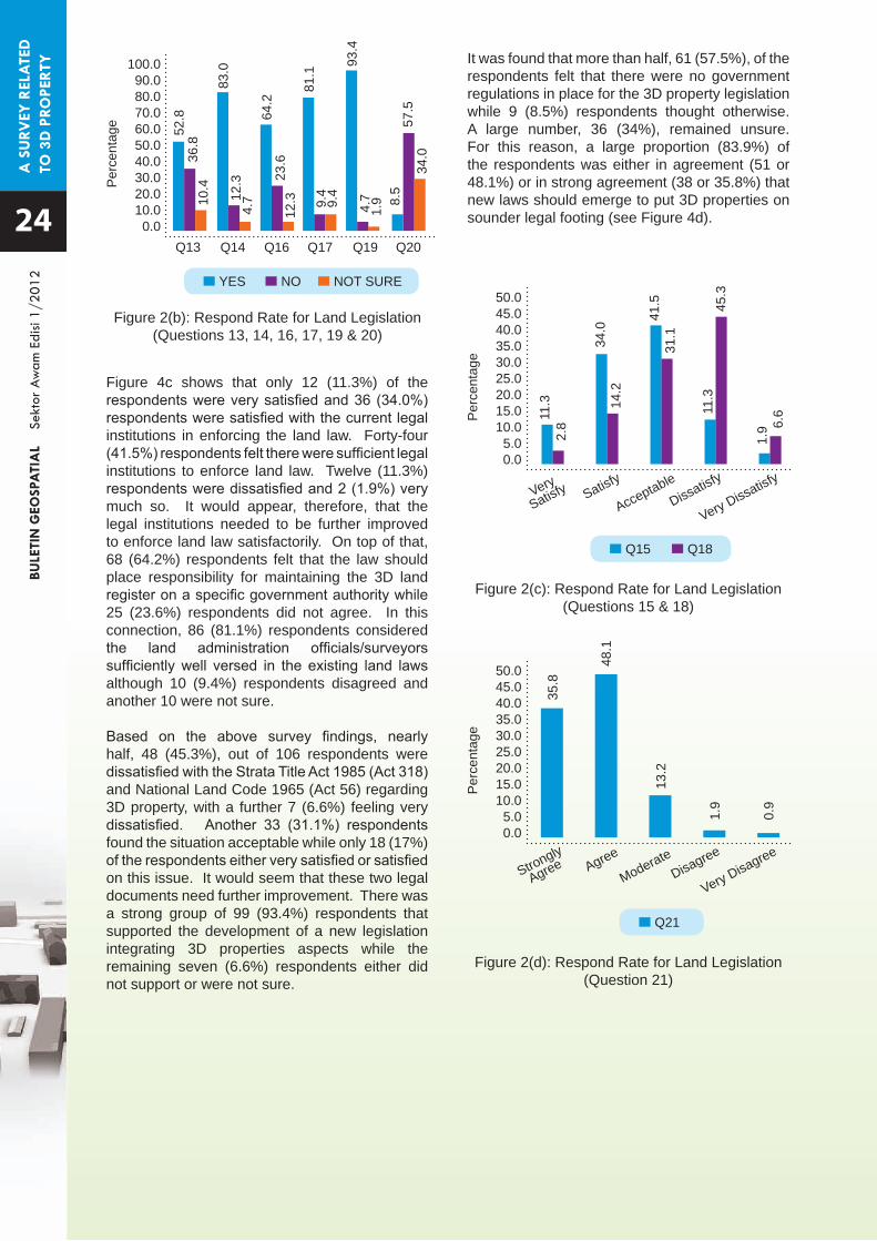
Based on the analysis from the 106 valid returned questionnaires, 76 (71.7%) respondents were of the opinion that there was no land law which embodied a right for people to hold and dispose of private rights in land in a 3D environment. Nineteen (17.9%) respondents thought the Strata Title Act 1985 provided for this while remaining 11 (10.4%) respondents were unsure. Only 10 (9.4%), 11 (10.4%) and 16 (15.1%) out of 106 respondents thought that the Strata Title Act 1985, the National Land Code 1965 and other land law such as Building and Common Property (Maintenance and Management) Act 2007 were respectively adequate and appropriate to support the land administration system in 3D environment. The remaining respective 86 (81.1%), 87 (82.1%), and 81 (76.4%) did not think so while 10 (9.4%), 8 (7.5%) and 9 (8.5%) respondents were not sure on these issues.
Figure 2(a) and Figure 2(b) show that 35 (33.0%) respondents thought that the current land laws defined 3D property rights clearly while 61 (57.5%) responded that they did not, and 10 (9.4%) were unsure. As a result of this, perhaps better 3D visualization should be developed and employed. Seventeen (16.0%) respondents opined that current land laws were being enforced adequately in all types of development and 56 (52.8%) thought the law recognised 3D property rights in mixed developments. Eighty two (77.4%) respondents and 39 (36.8%) respondents respectively thought otherwise. Meanwhile, the remaining respective 7
Land Legislation
This section presents the analysis on land legislation and the questions appearing in Table 1.The responses to the questionnaire are shown in Figure 2(a) to Figure 2(d).
Table 1: Questions on Land
7
8
9
10
111213141516
1718
192021
In Malaysia, there is a written Act, Code, Regulation, Rule or Ordinance which includes a right for people to hold and dispose of private rights in land in 3D environment. The Strata Title Act 1985 (Act 318) is adequate and appropriate to support the land administration system in 3D environment. The National Land Code 1965 (Act 56) is adequate and appropriate to support the land administration system in 3D environment. The current land laws are adequate and appropriate to support the land administration system in 3D environment (besides Strata Title Act 1985 and National Land Code 1965). The current land laws define 3D property rights clearly. Are current land laws enforced adequately in all types of development? Do the current land laws recognise the 3D property rights in mix development? Does the practice on the ground reflect the provisions in the current land laws? Are there sufficient legal institutions to enforce land law? Does the law place responsibility for maintaining the 3D land register on a specific minister, government department, institution or official post holder? Land administration officials/surveyors are well versed in the existing land law. What has been your overall level of satisfaction with the Strata Title Act 1985 (Act 318) and National Land Code 1965 (Act 56) regarding 3D property? Do you support the development of a new legislation that integrates 3D properties aspects? Are there any government arrangements in place for the 3D property legislation? This new law should serve to make the 3D property legislation available.
(6.6%) respondents and 11 (10.4%) respondents remained unsure. It is clear that the modern urban living and land usage needs are pushing hard on the existing laws. As an example, the transport hub at Kuala Lumpur Sentral where railroads, light rail transport systems, hotels, condominiums, car parks and various forms of utilities all crisscross over the same plot of land makes compliance with the provisions of laws difficult on the ground. Indeed, 88 (83.0%) respondents agreed that the practice on the ground reflected the provisions in the current land laws while 13 (12.3%) respondents responded that they did not.
Question
100.0090.080.070.060.050.040.030.020.010.00.0
Q7
Per
cent
age
Q8
YES NO NOT SURE
Q9 Q10 Q11 Q12
17.9
9.4
10.4 15
.1
33.0
16.0
10.4
9.4
7.5
8.5
9.4
9.4
5.6
71.7 81
.1
82.1
76.4
57.5
77.4
Figure 2(a): Respond Rate for Land Legislation (Questions 7-12)
A S
URV
EY R
ELA
TED
TO
3D
PRO
PERT
YBU
LETI
N G
EOSP
ATI
AL
Se
ktor
Aw
am E
disi
1/20
12
Figure 4c shows that only 12 (11.3%) of the respondents were very satisfied and 36 (34.0%) respondents were satisfied with the current legal institutions in enforcing the land law. Forty-four (41.5%) respondents felt there were sufficient legal institutions to enforce land law. Twelve (11.3%) respondents were dissatisfied and 2 (1.9%) very much so. It would appear, therefore, that the legal institutions needed to be further improved to enforce land law satisfactorily. On top of that, 68 (64.2%) respondents felt that the law should place responsibility for maintaining the 3D land register on a specific government authority while 25 (23.6%) respondents did not agree. In this connection, 86 (81.1%) respondents considered the land administration officials/surveyors sufficiently well versed in the existing land laws although 10 (9.4%) respondents disagreed and another 10 were not sure.
Based on the above survey findings, nearly half, 48 (45.3%), out of 106 respondents were dissatisfied with the Strata Title Act 1985 (Act 318) and National Land Code 1965 (Act 56) regarding 3D property, with a further 7 (6.6%) feeling very dissatisfied. Another 33 (31.1%) respondents found the situation acceptable while only 18 (17%) of the respondents either very satisfied or satisfied on this issue. It would seem that these two legal documents need further improvement. There was a strong group of 99 (93.4%) respondents that supported the development of a new legislation integrating 3D properties aspects while the remaining seven (6.6%) respondents either did not support or were not sure.
100.090.080.070.060.050.040.030.020.010.00.0
50.045.040.035.030.025.020.015.010.05.00.0
50.045.040.035.030.025.020.015.010.05.00.0
Q13
Very
Satisfy
Strongly
Agree
Satisfy
Agree
Acceptable
Moderate
Dissatisfy
Disagree
Very Dissatisfy
Very Disagree
Per
cent
age
Per
cent
age
Per
cent
age
Q14
YES
Q15
Q21
NO
Q18
NOT SURE
Q16 Q17 Q19 Q20
52.8
11.3
35.8
34.0
48.1
41.5
13.2
11.3
1.9
83.0
64.2
81.1
93.4
8.5
10.4
4.7
12.3 9.4
1.9
34.036
.8
2.8
14.2
31.1
45.3
1.9
6.6
0.9
12.3 23
.6
9.4
4.7
57.5
Figure 2(b): Respond Rate for Land Legislation (Questions 13, 14, 16, 17, 19 & 20)
Figure 2(c): Respond Rate for Land Legislation (Questions 15 & 18)
Figure 2(d): Respond Rate for Land Legislation (Question 21)
It was found that more than half, 61 (57.5%), of the respondents felt that there were no government regulations in place for the 3D property legislation while 9 (8.5%) respondents thought otherwise. A large number, 36 (34%), remained unsure. For this reason, a large proportion (83.9%) of the respondents was either in agreement (51 or 48.1%) or in strong agreement (38 or 35.8%) that new laws should emerge to put 3D properties on sounder legal footing (see Figure 4d). 24

A S
URV
EY R
ELA
TED
TO
3D
PRO
PERT
YBU
LETI
N G
EOSP
ATI
AL
Se
ktor
Aw
am E
disi
1/20
12
25
Land Administration
This section presents the analysis on land administration and the questions appearing in Table 2.The responses to the questionnaire are shown in Figure 3(a) to Figure 3(e).
Table 2: Questions on Land Administration
When asked whether Malaysia had a statutory system of land registration which recorded land rights, including ownership in a 3D environment, there was a significant group of 65 (61.3%) respondents that agreed whereas 29 (27.4%) respondents disagreed. Fifty (47.2%) out of 106 respondents agreed and 16 (15.1%) respondents strongly agreed that some of the buildings had been built on top of each other or crossed boundary edges in real estate developments. The remaining 25 (23.6%) stayed neutral and only 10 (9.4%) were in disagreement and another 5 (4.7%) in strong disagreement. It was generally felt that, there should be one, and only one, authority conferred with the authority to guarantee and authenticate land titles. There was concern that the security of tenures could otherwise be jeopardized. Accordingly, 82 (77.4%) respondents expected it to be easy to register properties in 3D with a single authority although 24 (22.6%) respondents thought it would be similarly easy with multiple authorities.
Malaysia has a statutory system of land registration which records rights in land, including ownership, in a public register in 3D environment. In real estate developments, some of the buildings have been built on top of each other or they cross boundary edges?The registration of properties in 3D environment is easy in multi authority or in single authority?There is a need for a legal registration status of 3D property. The existing law and guideline for stratum which under Part Five (A), Disposal of Underground Land, Section 92A to 92I, National Land Code 1965 can be used as a basis for 3D property volumetric land parcel alienation on and above the ground surface. 3D property legislation has an important role to play in achieving 3D property rights for Malaysia. It is compulsory for those obtaining 3D new rights in land to register those rights. What forms of land holdings should register in this new 3D environment. If leases are registered, what is the minimum term in years (how long) of a lease for it to qualify for registration?What, in your opinion, are the key problems with the current legislation that deal which 3D properties? What have been the key benefits and issues in the development and operation of the 3D property legislation?
Question22
23
242526
27282930
3132
100.0090.080.070.060.050.040.030.020.010.00.0
100.0090.080.070.060.050.040.030.020.010.00.0
Per
cent
age
Per
cent
age
Q22
Q24
Q27
61.3
22.6
89.6
77.4
27.4
3.8 11
.3
6.5
Figure 3(a): Respond Rate for Land Administration (Questions 22 & 27)
Figure 3(b): Respond Rate for Land Administration (Question 24)
Yes
Multi Authority Single Authority
No Not Sure

A S
URV
EY R
ELA
TED
TO
3D
PRO
PERT
YBU
LETI
N G
EOSP
ATI
AL
Se
ktor
Aw
am E
disi
1/20
12
Almost equal numbers of respondents (45 or 42.5% and 42 or 39.6%) strongly agreed or agreed respectively that there was a need for a legal registration status of 3D property. Fifteen (14.2%) respondents took a moderate stance and only a small number of respondent either disagreed or strongly disagreed. A great number of respondents, 74 (69.8%) either agreed or strongly agreed, opined that the existing law and guideline for stratum under Part Five (A), Disposal of Underground Land, Section 92A to 92I, National Land Code 1965 could be used as a basis for 3D property volumetric land parcel alienation on and above the ground surface. Twenty five (23.6%) respondents remained uncommitted on this issue. Altogether, 95 (89.6%) respondents responded that appropriate new legislation had an important role to play in achieving 3D property rights for Malaysia, with only four (3.8%) responding negative to the question while the remaining seven (6.6%) respondents were unsure on this matter.
Almost half of the respondents 43 (40.6%) and 44 (41.5%) either strongly agreed or agreed that it should be made compulsory for those obtaining 3D new rights in land to register those rights, whether on, above or below ground surface. At the same time, there were 17 (16%) who choose to stay uncommitted on this issue. There were another 2 (1.9%) respondents who disagreed. None strongly disagreed. A majority of the respondents, 69 (65.1%) out of 106, thought that the new 3D property should be registered as leasehold rather than freehold properties. If leases were registered, two thirds of the respondents, totalling 73 (68.9%) and 22 (20.8%) felt that the leases should run at least 60 or 99 years respctively to maintain the worth of the asset and for it to be easily transferable. Eleven (10.4%) respondents opined that the lease should only be 21 years.
Many of the respondents considered that a key problem with the current legislation that dealt which 3D properties lay with the legislators who were slow to take cognisance of, and respond to the need for changes that were essential for a better system of land registration and property management. Finally, the respondents felt that it would allow for a better quality of living in the urban centre, taking advantage of the services and facilities provided by local authorities, once the legislation on 3D environment was implemented.
100.0090.080.070.060.050.040.030.020.010.00.0
100.0090.080.070.060.050.040.030.020.010.00.0
Per
cent
age
Per
cent
age
34.9
10.4
65.1
68.9
20.3
Q29
21 years 60 years 99 years
Figure 3(d): Respond Rate for Land Administration (Question 29)
Figure 3(e): Respond Rate for Land Administration (Question 30)
Freehold
Q30
Leasehold
60.0
50.0
40.0
30.0
20.0
10.0
0.0
Per
cent
age
Q23 Q25 Q26 Q28
15.1
47.2
23.6
9.4
4.7
15.1
54.7
23.6
5.7
0.9
40.6 41.5
16.0
1.9
0.0
42.5
39.6
14.2
0.9 2.8
Figure 3(c): Respond Rate for Land Administration (Questions 23, 25, 26 & 28)
Strongly
Agree AgreeModerate
Disagree
Very Disagree
26
A S
URV
EY R
ELA
TED
TO
3D
PRO
PERT
YBU
LETI
N G
EOSP
ATI
AL
Se
ktor
Aw
am E
disi
1/20
12
27
Cadastre Registration
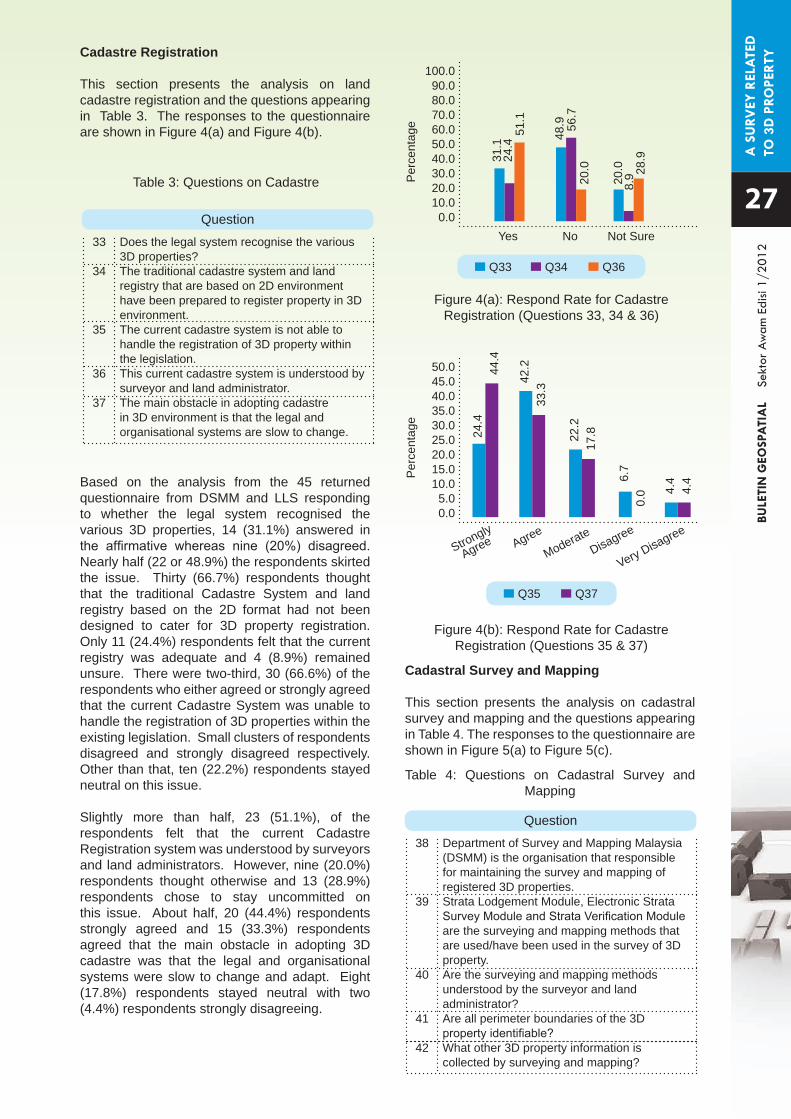
This section presents the analysis on land cadastre registration and the questions appearing in Table 3. The responses to the questionnaire are shown in Figure 4(a) and Figure 4(b).
Based on the analysis from the 45 returned questionnaire from DSMM and LLS responding to whether the legal system recognised the various 3D properties, 14 (31.1%) answered in the affirmative whereas nine (20%) disagreed. Nearly half (22 or 48.9%) the respondents skirted the issue. Thirty (66.7%) respondents thought that the traditional Cadastre System and land registry based on the 2D format had not been designed to cater for 3D property registration. Only 11 (24.4%) respondents felt that the current registry was adequate and 4 (8.9%) remained unsure. There were two-third, 30 (66.6%) of the respondents who either agreed or strongly agreed that the current Cadastre System was unable to handle the registration of 3D properties within the existing legislation. Small clusters of respondents disagreed and strongly disagreed respectively. Other than that, ten (22.2%) respondents stayed neutral on this issue.
Slightly more than half, 23 (51.1%), of the respondents felt that the current Cadastre Registration system was understood by surveyors and land administrators. However, nine (20.0%) respondents thought otherwise and 13 (28.9%) respondents chose to stay uncommitted on this issue. About half, 20 (44.4%) respondents strongly agreed and 15 (33.3%) respondents agreed that the main obstacle in adopting 3D cadastre was that the legal and organisational systems were slow to change and adapt. Eight (17.8%) respondents stayed neutral with two (4.4%) respondents strongly disagreeing.
Table 3: Questions on Cadastre
Cadastral Survey and Mapping
This section presents the analysis on cadastral survey and mapping and the questions appearing in Table 4. The responses to the questionnaire are shown in Figure 5(a) to Figure 5(c).
Table 4: Questions on Cadastral Survey and Mapping
Does the legal system recognise the various 3D properties? The traditional cadastre system and land registry that are based on 2D environment have been prepared to register property in 3D environment. The current cadastre system is not able to handle the registration of 3D property within the legislation. This current cadastre system is understood by surveyor and land administrator. The main obstacle in adopting cadastre in 3D environment is that the legal and organisational systems are slow to change.
Department of Survey and Mapping Malaysia (DSMM) is the organisation that responsible for maintaining the survey and mapping of registered 3D properties. Strata Lodgement Module, Electronic Strata Survey Module and Strata Verification Module are the surveying and mapping methods that are used/have been used in the survey of 3D property. Are the surveying and mapping methods understood by the surveyor and land administrator? Are all perimeter boundaries of the 3D property identifiable? What other 3D property information is collected by surveying and mapping?
Question
Question
33
34
35
36
37
38
39
40
41
42
100.090.080.070.060.050.040.030.020.010.00.0
Yes
Per
cent
age
No Not Sure
31.1
48.9
20.0
51.1
20.0 28
.924.4
56.7
8.9
Q33 Q34 Q36
Figure 4(a): Respond Rate for Cadastre Registration (Questions 33, 34 & 36)
50.045.040.035.030.025.020.015.010.05.00.0
Strongly
Agree Agree
ModerateDisagree
Very Disagree
Per
cent
age
24.4
42.2
22.2
6.7
4.4
44.4
33.3
17.8
0.0 4.
4
Q35 Q37
Figure 4(b): Respond Rate for Cadastre Registration (Questions 35 & 37)

A S
URV
EY R
ELA
TED
TO
3D
PRO
PERT
YBU
LETI
N G
EOSP
ATI
AL
Se
ktor
Aw
am E
disi
1/20
12
Figure 5(a) and Figure 5(b) show that from the 45 returned questionnaire from DSMM and LLS, more than two-third, 37 (82.2%) of the total respondents either strongly agreed or agreed that DSMM should be responsible for maintaining the survey and mapping of registered 3D properties, whereas only 5 (11.1%) respondents were moderate in their view. Three (6.7%) respondents disagreed with it while none disagreed strongly. Concerning the suggestion that the Strata Lodgement Module, Electronic Strata Survey Module and Strata Verification Module had been the surveying and mapping methods that were used in the survey of 3D property, only slightly more than one-third, 16 (35.5%) indicated either they were satisfied or very satisfied with the statement. Nineteen (42.2%) respondents stayed neutral whereas 8 (17.8%) respondents expressed dissatisfaction.
The results of the survey also showed that more than half, 28 (62.2%) of the respondents considered surveying and mapping methods to be understood by surveyors and land administrators while slightly more the one-third, 17 (37.8%) respondents either disagreed or unsure. Out of 45 respondents, 26 (57.8%) respondents were of the opinion that all perimeter boundaries of the 3D property were identifiable. Nevertheless, 13 (28.9%) respondents thought otherwise, while the remaining 6 (13.3%) were unsure whether physical or virtual boundaries were identifiable (see Figure 5(c)).
Finally, many respondents felt that other relevant information on 3D properties and their regulation should be collated. Unlike the situation where the limits of the properties were only surveyed and indicated on plans, 3D geographical visualization methods could be employed to record many identifiable features as land users, facade, front, back, and side elevations, services, utilities, lamppost, traffic lights, even the roof, and the whole multitude can be captured and shown. The captured features and data would vary according to need.
100.0090.080.070.060.050.040.030.020.010.00.0
100.0090.080.070.060.050.040.030.020.010.00.0
Strongly
Agree
Very
Satisfy
Agree
Satisfy
Moderate
Acceptable
Disagree
Dissatisfy
Very Disagree
Very Dissatisfy
Per
cent
age
Per
cent
age
48.9
13.3
33.3
22.2
11.1
42.2
6.7
17.8
0.0
4.4
Q38
Q39
Figure 5(a): Respond Rate for Cadastral Survey and Mapping (Question 38)
Figure 5(c): Respond Rate for Cadastral Survey and Mapping (Questions 40 & 41)
Figure 5(b): Respond Rate for Cadastral Survey and Mapping (Question 39)
100.0090.080.070.060.050.040.030.020.010.00.0
Per
cent
age
62.2
57.8
15.6
28.9
22.2
13.3
Q40 Q41
Yes No Not Sure
28
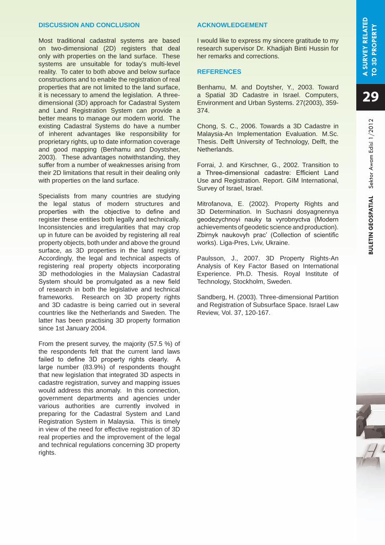
A S
URV
EY R
ELA
TED
TO
3D
PRO
PERT
YBU
LETI
N G
EOSP
ATI
AL
Se
ktor
Aw
am E
disi
1/20
12
29
DISCUSSION AND CONCLUSION
Most traditional cadastral systems are based on two-dimensional (2D) registers that deal only with properties on the land surface. These systems are unsuitable for today’s multi-level reality. To cater to both above and below surface constructions and to enable the registration of real properties that are not limited to the land surface, it is necessary to amend the legislation. A three-dimensional (3D) approach for Cadastral System and Land Registration System can provide a better means to manage our modern world. The existing Cadastral Systems do have a number of inherent advantages like responsibility for proprietary rights, up to date information coverage and good mapping (Benhamu and Doystsher, 2003). These advantages notwithstanding, they suffer from a number of weaknesses arising from their 2D limitations that result in their dealing only with properties on the land surface.
Specialists from many countries are studying the legal status of modern structures and properties with the objective to define and register these entities both legally and technically. Inconsistencies and irregularities that may crop up in future can be avoided by registering all real property objects, both under and above the ground surface, as 3D properties in the land registry. Accordingly, the legal and technical aspects of registering real property objects incorporating 3D methodologies in the Malaysian Cadastral System should be promulgated as a new field of research in both the legislative and technical frameworks. Research on 3D property rights and 3D cadastre is being carried out in several countries like the Netherlands and Sweden. The latter has been practising 3D property formation since 1st January 2004.
From the present survey, the majority (57.5 %) of the respondents felt that the current land laws failed to define 3D property rights clearly. A large number (83.9%) of respondents thought that new legislation that integrated 3D aspects in cadastre registration, survey and mapping issues would address this anomaly. In this connection, government departments and agencies under various authorities are currently involved in preparing for the Cadastral System and Land Registration System in Malaysia. This is timely in view of the need for effective registration of 3D real properties and the improvement of the legal and technical regulations concerning 3D property rights.
ACKNOWLEDGEMENT
I would like to express my sincere gratitude to my research supervisor Dr. Khadijah Binti Hussin for her remarks and corrections.
REFERENCES
Benhamu, M. and Doytsher, Y., 2003. Toward a Spatial 3D Cadastre in Israel. Computers, Environment and Urban Systems. 27(2003), 359-374.
Chong, S. C., 2006. Towards a 3D Cadastre in Malaysia-An Implementation Evaluation. M.Sc. Thesis. Delft University of Technology, Delft, the Netherlands.
Forrai, J. and Kirschner, G., 2002. Transition to a Three-dimensional cadastre: Efficient Land Use and Registration. Report. GIM International, Survey of Israel, Israel.
Mitrofanova, E. (2002). Property Rights and 3D Determination. In Suchasni dosyagnennya geodezychnoyi nauky ta vyrobnyctva (Modern achievements of geodetic science and production). Zbirnyk naukovyh prac’ (Collection of scientific works). Liga-Pres, Lviv, Ukraine.
Paulsson, J., 2007. 3D Property Rights-An Analysis of Key Factor Based on International Experience. Ph.D. Thesis. Royal Institute of Technology, Stockholm, Sweden.
Sandberg, H. (2003). Three-dimensional Partition and Registration of Subsurface Space. Israel Law Review, Vol. 37, 120-167.
GIS
SA
NA
-SIN
IBU
LETI
N G
EOSP
ATI
AL
Se
ktor
Aw
am E
disi
1/20
12
Sana-Sini
The Singapore Land Authority (SLA) is a statutory board under the Ministry of Law and it is the national land registration authority. SLA is responsible for the management of State land and buildings, land sales, leases, acquisitions and allocation, developing and marketing land-related information and maintaining the national land information database.
5th January 2012
TECHNICAL VISIT FROMSINGAPORE LAND AUTHORITY
(SLA) DELEGATION TO MaCGDI
30
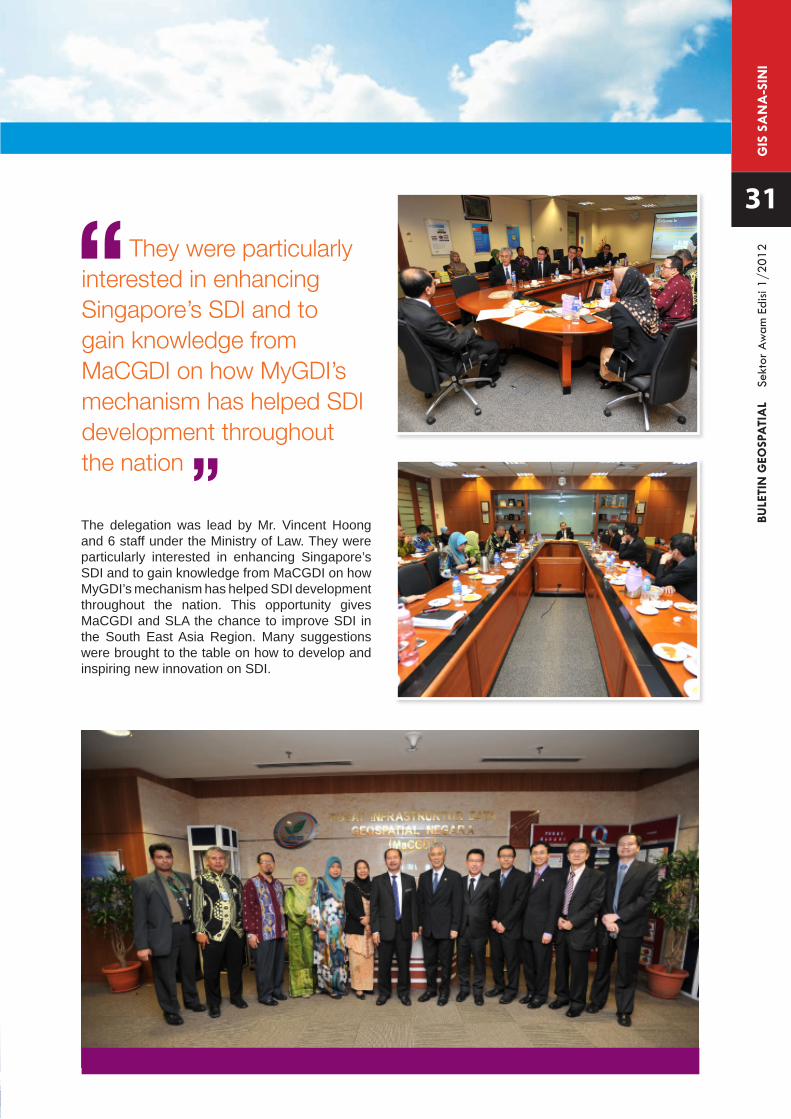
GIS
SA
NA
-SIN
IBU
LETI
N G
EOSP
ATI
AL
Se
ktor
Aw
am E
disi
1/20
12
31
They were particularly interested in enhancing Singapore’s SDI and to gain knowledge from MaCGDI on how MyGDI’s mechanism has helped SDI development throughout the nation
The delegation was lead by Mr. Vincent Hoong and 6 staff under the Ministry of Law. They were particularly interested in enhancing Singapore’s SDI and to gain knowledge from MaCGDI on how MyGDI’s mechanism has helped SDI development throughout the nation. This opportunity gives MaCGDI and SLA the chance to improve SDI in the South East Asia Region. Many suggestions were brought to the table on how to develop and inspiring new innovation on SDI.
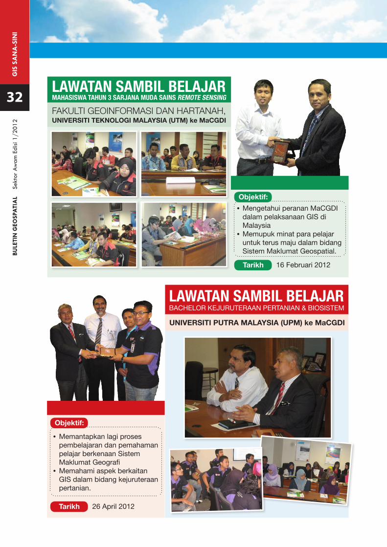
GIS
SA
NA
-SIN
IBU
LETI
N G
EOSP
ATI
AL
Se
ktor
Aw
am E
disi
1/20
12
BACHELOR KEJURUTERAAN PERTANIAN & BIOSISTEMLAWATAN SAMBIL BELAJAR
UNIVERSITI PUTRA MALAYSIA (UPM) ke MaCGDI
32 MAHASISWA TAHUN 3 SARJANA MUDA SAINS REMOTE SENSINGLAWATAN SAMBIL BELAJAR
• Mengetahui peranan MaCGDI dalam pelaksanaan GIS di Malaysia
• Memupuk minat para pelajar untuk terus maju dalam bidang Sistem Maklumat Geospatial.
• Memantapkan lagi proses pembelajaran dan pemahaman pelajar berkenaan Sistem Maklumat Geografi •Memahami aspek berkaitan
GIS dalam bidang kejuruteraan pertanian.
Objektif:
Objektif:
Tarikh
Tarikh
16 Februari 2012
26 April 2012
FAKULTI GEOINFORMASI DAN HARTANAH,UNIVERSITI TEKNOLOGI MALAYSIA (UTM) ke MaCGDI
Buletin Geospatial Sektor Awam diterbitkan dua (2) kali setahun oleh Pusat Infrastruktur DataGeospatial Negara (MaCGDI). Sidang Pengarang amat mengalu-alukan sumbangan sama adaberbentuk artikel atau laporan bergambar mengenai perkembangan Sistem Maklumat Geografi (GIS) di Agensi Kerajaan, Badan Berkanun dan Institusi Pengajian Tinggi.
GARIS PANDUAN UNTUK PENULIS
1. Manuskrip boleh ditulis dalam Bahasa Melayu atau Bahasa Inggeris.
2. Setiap artikel perlu mempunyai abstrak dan perlu ditulis dengan huruf condong (italic).
3. Format manuskrip adalah seperti berikut:
Jenis huruf (font) : Arial Saiz huruf bagi tajuk : 12 Saiz huruf : 10 Langkau (spacing) : single Margin : Atas, bawah, kiri dan kanan = 2.5 cm Justifikasi teks : Kiri Lajur (column) : Satu lajur setiap mukasurat
4. Sumbangan hendaklah dikemukakan dalam bentuk softcopy dalam format Microsoft Word.
5. Semua imej grafik hendaklah dibekalkan dalam format .tif atau .jpg dengan resolusi tidak kurang daripada 150 d.p.i.
6. Segala pertanyaan dan sumbangan hendaklah dikemukakan kepada :
Ketua Editor Buletin Geospatial Sektor Awam Pusat Infrastruktur Data Geospatial Negara (MaCGDI) Kementerian Sumber Asli dan Alam Sekitar Aras 7 & 8, Wisma Sumber Asli No. 25, Persiaran Perdana, Presint 4 62574 Putrajaya
Tel : +603-88861111 Faks : +603-88894851 Email : [email protected]
BULETIN GEOSPATIALSEKTOR AWAM
FORMAT DAN GARIS PANDUAN SUMBANGAN ARTIKEL
