landslide risk management (lrm): towards a better disaster
TRANSCRIPT
* Corresponding author’s e-mail: [email protected]
ASM Sc. J., 12, Special Issue 3, 2019 for ICST2018, 70 - 81
Landslide Risk Management (LRM): Towards a Better Disaster Risk Reduction (DRR)
Programme in Malaysia
Rodeano Roslee 1,2
1Natural Disaster Research Centre (NDRC), University Malaysia Sabah (UMS),
Jalan UMS, 88400 Kota Kinabalu, Sabah, MALAYSIA
2Faculty of Science and Natural Resources (FSSA), University Malaysia Sabah (UMS),
Jalan UMS, 88400 Kota Kinabalu, Sabah, MALAYSIA
Landslide Risk Management (LRM) is relatively new and received little attention from geoscientists and
stakeholders in addressing landslide geodisaster especially in Malaysia. The main objective of this paper
was to develop a practical and comprehensive model of LRM for Malaysia. To achieve this goal, firstly; a
database was developed through literature review, landslide inventory, fieldwork and laboratory studies.
Secondly, is Landslide Hazard Assessment (LHAs) determination. Thirdly, Landslide Risk Elements
Identification (LREI) (population and properties value) and Landslide Vulnerability Assessment (LVAs)
(Physical, Social and Environmental). Fourthly, Landslide Risk Estimation (LREt). Fifthly, Landslide Risk
Evaluation (LREv) is conducted based on the F-N curve and Risk Evaluation Triangular (RET) figures,
which was designed to determine the Risk Tolerance Index (RTI). Finally, to determine the appropriate
Landslide Risk Treatment (LRT) either structural or non-structural approaches. The study
concludes/suggests that the LRM model involves defining the LHAs, LREI, LVAs, LREt, LREv and LRT.
This LRM model is suitable for development planning, the selection of land use suitability, control and
manage the landslide hazard/risk in Malaysia and potentially to be extended with different background
environments.
Keywords: Landslide Risk Evaluation (LREv); F-N curve; Risk Tolerance Index (RTI); Landslide Risk
Management (LRM)
I. INTRODUCTION
The occurrence of landslide shows a growing trend in the
future although much effort has been made to reduce the
risk. Global climate change, human ignorance, population
growth, ecosystem damage and environmental quality
deterioration have contributed to the increased degree of
hazard and risk of landslides.
In Malaysia, the issue of landslide successfully attracted
the interest and attention of stakeholders and the
community of scientists to reduce the risk. Authorities as
well as individuals or organizations have spent millions of
ringgit to treat the risk of landslides. Landslide are an
important issue in urban areas and hills that are vulnerable
to tropical storm threats and prolonged rainy seasons. This
disaster is usually associated with other geological disasters
such as floods and earthquake. Although there are several
records of damage due to landslide disaster in Malaysia, the
information is not comprehensive.
Historical of landslide records are also incomplete due to
the absence of good and systematic database of landslide
inventory and systems. Therefore, the scopes of landslide
studies in Malaysia was limited and focused mainly on
mapping of landslide location, slope stability analysis and
slope design. This scopes of this study is considered to be
inadequate in the context of Landslide Risk Management
ASM Science Journal, Volume 12, Special Issue 3, 2019 for ICST2018
71
(LRM). The LRM system introduced in this paper is
comprehensive and interdependent as it is able to analyze,
estimate, evaluate and manage the risk of landslides
effectively especially in areas with varying degrees of
hazards, adverse impacts and risks. The LRM system is also
useful in making the selection of land use suitability and
development planning.
The ultimate goal of LRM studies is to protect the
population, the economy and the environment against
potential damage caused by landslides. This requires an
accurate assessment of the level of threat from a landslide:
an objective reproducible, justifiable and meaningful
measure of risk (Crozier & Glade, 2005). Risk, in this
context, is seen as a disaster that could happen in the
future. Considering this relationship, it is evident that an
accurate assessment model is of the utmost importance as it
may under- or over-estimate the occurrence of future
events. However, there is not yet a common agreement on
LRM at least for landslide disasters and still many issues on
methods and data remain partially under research
(Castellanos, 2008). It is also relevant the spatial dimension
of risk which depend on locations and on scales in which
the assessment is carried out. Taking into account the
importance and characteristics for disaster reduction, the
investigations on risk assessment has increased enormously
in the last decade.
II. TERMINOLOGY
One of the motivations for generating standard concepts
about landslide came up with the idea of producing a World
Landslide Inventory (WLI). In order to support the
implementation of the WLI, some publications were
produced by the IAEG Commission on Landslides, the
UNESCO working party on world landslide inventory and
later by the IUGS Working Group on Landslides. These
publications have led to support a certain level of
standardization in fields related to landslides, including:
nomenclature for landslides (IAEG-Commission on
Landslides, 1990; UNESCO-WP/WLI, 1993a), activity of
landslides (UNESCOWP/WLI, 1993b), causes of landslides
(UNESCO-WP/WLI, 1994), rate of movement of a landslide
(IUGS-Working group on landslide, 1995) and remedial
measures for landslides (IUGS-Working group on landslide,
2001).
Recently, the three geotechnical societies ISSMGE, ISRM
and IAEG have created the a so called Joint Technical
Committee on Landslides and Engineered Slopes (JTC-1),
which continues to work in the standardization and
promotion of research on landslides among the different
disciplines (Castellanos, 2008). Therefore, Landslide Risk
Management (LRM) requires communication, not only
among engineers and geoscientists, but also among
specialists from other fields of expertise. To ensure effective
communications, the profession needs to agree on and use
consistent terminology. For this reason, the most important
terms are first defined in this paper.
The terminology used in this paper is consistent with the
"Glossary of Terms for Risk Assessment" developed by
Technical Committee on Risk Assessment and
Management (TC32) of the International Society of Soil
Mechanics and Geotechnical Engineering (ISSMGE)
(www.engmath.dal.ca/tc32). Some other related
terminology are also referred to as Crozier & Glade (2005),
AGS (2007a; 2007b, 2007c; 2007d; 2007e) and UPC
(2011).
Acceptable risk: A risk which everyone impacted is
prepared to accept. Action to further reduce such risk is
usually not required unless reasonably practicable measures
are avail- able at low cost in terms of money, time and
effort.
ALARP (As Low As Reasonably Practicable) principle:
The principle which states that risks, lower than the limit of
tolerability, are tolerable only if risk reduction is
impracticable or if its cost is grossly in disproportion
(depending on the level of risk) to the improvement gained.
Consequence: In relation to risk analysis, the outcome or
result of a hazard being realized.
Danger (Threat): The natural phenomenon that could
lead to damage, described in terms of its geometry,
magnitude, mechanical and other characteristics. The
danger can be an existing one (such as a creeping slope) or
a potential one (such as a tsunami). The characterization of
a danger or threat does not include any spatial-temporal
probability or forecasting.
Deterministic: Describing a process with an outcome
that is always the same for a given set of inputs, i.e. the
outcome is "determined" by the input. Deterministic
contrasts with random, which describes a process with an
outcome that can vary even though the inputs are the same.
Deterministic analysis contrasts with probabilistic analysis.
Disaster: Serious function disorders that exceed the
ASM Science Journal, Volume 12, Special Issue 3, 2019 for ICST2018
72
ability of the community or society to wreak havoc on
human, material, economic or environmental damage.
Disasters are a result of harmful combinations, adverse
effects and inadequate capacity or measures to reduce risky
negative impacts.
Elements at risk: Population, buildings and engineering
works, infrastructure, environ- mental features and
economic activities in the area affected by a hazard. Also, a
set of conditions and processes resulting from physical,
social, economic, and environmental factors, which increase
the susceptibility of a community to the impact of hazards.
F-N curves: Curves relating the probability per year of
causing N or more fatalities (F) to N. This is the
complementary cumulative distribution function. Such
curves may be used to express societal risk criteria and to
describe the safety levels of particular facilities.
Frequency: A possible action expressed as the number of
occurrences of an event within a specified time or the
number of numbers given in the experiment.
Hazard: Probability that a particular danger (threat)
occurs within a given period of time.
Individual risk: The risk of fatality or injury to any
identifiable (named) individual who live in the zone
impacted by the landslide; or follows a particular pattern of
life that might subject him or her to the consequences of the
landslide.
Landslide inventory: Inventory on location, classification,
amount, activity and date of landslide.
Likelihood: Used as a qualitative explanation of the
probability or frequency.
Loss: Any negative consequence, financial or otherwise.
Probabilistic: A description of procedures, which are
based on the application of the laws of probability.
Contrasts with deterministic.
Probability: A measure of the degree of certainty. This
measure has a value between zero (impossibility) and 1.0
(certainty). It is an estimate of the likelihood of the
magnitude of the uncertain quantity, or the likelihood of the
occurrence of the uncertain future event.
Preparedness: Activities and steps taken first to ensure
effective response to disaster and its consequences.
Prevention: Activities to avoid any disastrous
consequences and outcomes.
Reliabilty: A measurement of the system or part of the
system to prevent the occurrence of a disaster.
Resilience: A measure of recovery or rebounding of a
natural system to return to its original state after a disaster
event.
Residual risk: The level of risk at any time before, during
and after the program of risk mitigation measures has been
taken.
Risk: Measure of the probability and severity of an
adverse effect to life, health, property, and/or the
environment. Quantitatively, Risk = f (Hazard, Potential
Worth of Loss). This is commonly expressed as "Probability
of an adverse event times the consequences of that event".
Risk analysis: The use of available information to
estimate the risk to individuals or populations, property, or
the environment, from hazards. Risk analysis generally
contains the following steps: scope definition, hazard
identification, and risk estimation.
Risk assessment: The process of making a decision
recommendation on whether existing risks are tolerable
and present risk control measures are adequate, and if not,
whether alternative risk control measures are justified or
will be implemented. Risk assessment incorporates the risk
analysis and risk evaluation phases.
Risk estimation: the process used to produce a measure of
the level of health, property, or environmental risks being
analysed. Risk estimation contains the followings steps:
frequency analysis, consequence analysis and their
integration.
Risk evaluation: The stage at which values and judgment
enter the decision process, explicitly or implicitly, by
including consideration of the importance of the
estimated risks and the associated social, environmental,
and economic consequences, in order to identify a range of
alternatives for managing the risks.
Risk management: The systematic application of
management policies, procedures and practices to the tasks
of identifying, analysing, assessing, mitigating and
monitoring risk.
Risk control or risk treatment: the process of decision
making for managing risks, and the implementation, or
enforcement of risk mitigation measures and the re-
evaluation of its effectiveness from time to time, using the
results of risk assessment as one input.
Sensitivity analysis: Analysis to determine the different
range results in terms of unit changes or input parameters.
Societal risk: The risk of widespread or large scale
detriment from the realisation of a defined risk, the
implication being that the consequence would be on such a
scale as to provoke a socio/political response.
Susceptibility: Assessment quantitatively or qualitatively
ASM Science Journal, Volume 12, Special Issue 3, 2019 for ICST2018
73
for the classification, volume (or area) and spatial
distribution of soil present or potential occurrence in an
area.
Tolerable risk: A risk within a range that society can live
with so as to secure certain net benefits. It is a range of risks
regarded as non-negligible and needing to be kept under
review and reduced further if possible.
Total risk: The consequences (loss) expected to come
from a level of danger somewhere over a certain period of
time. The amount of risk depends not only on the disaster
process but also on the risky elements and the effects of
their adverse effects.
Uncertainty: Evidence of any situation without certainty
not described by the probability distribution. Uncertainty
due to natural change and / or incomplete knowledge (lack
of understanding or insufficient data).
Voluntary risk: The risk that a person faces voluntarily
for some benefits.
Vulnerability: The degree of loss to a given element or set
of elements within the area affected by a hazard. It is
expressed on a scale of 0 (no loss) to 1 (total loss).
III. LANDSLIDE RISK MANAGEMENT
(LRM) FRAMEWORK
Several frameworks have been proposed, e.g. AGS
(2000); Aleotti and Chowdhury (1999); Dai et al. (2002);
Einstein (1988); Fell (1994); Fell and Hartford (1997); Fell
et al. (2005); GEO (1999); Ho et al. (2000); IUGS (1997);
Lee and Jones (2004); Morgenstern (1997); Nadim and
Lacasse (2003); NRC (1996); Roberds (2001); Varnes
(1984); Whitman (1984); Wu et al. (1996). The proposed
frameworks have the common objective of answering the
following questions (after Ho et al., 2000; Lee & Jones,
2004; and Lacasse & Nadim, 2006):
1. What are the probable dangers? [Danger
Identification];
2. What would be the magnitude of dangers? [Hazard
Assessment];
3. What are the elements at risk? [Elements at Risk
Identification];
4. What might be the degree of damage to the
elements at risk? [Vulnerability Assessment];
5. What is the probability of damage? [Risk Estimation];
6. What is the significance of the estimated risk? [Risk
Evaluation]; and
7. What should be done? [Risk Management].
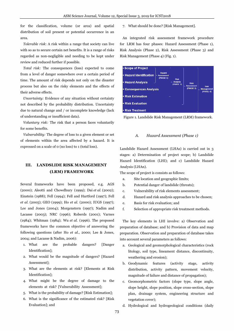
An integrated risk assessment framework procedure
for LRM has four phases: Hazard Assessment (Phase 1),
Risk Analysis (Phase 2), Risk Assessment (Phase 3) and
Risk Management (Phase 4) (Fig. 1).
Figure 1. Landslide Risk Management (LRM) framework.
A. Hazard Assessment (Phase 1)
Landslide Hazard Assessment (LHAs) is carried out in 3
stages: a) Determination of project scope; b) Landslide
Hazard Identification (LHI); and c) Landslide Hazard
Analysis (LHAn).
The scope of project is consists as follows:
a. Site location and geographic limits;
b. Potential danger of landslide (threats);
c. Vulnerability of risk elements assessment;
d. Hazard and risk analysis approaches to be chosen;
e. Basis for risk evaluation; and
f. Selection of appropriate risk treatment methods.
The key elements in LHI involve: a) Observation and
preparation of database; and b) Provision of data and map
preparation. Observation and preparation of database takes
into account several parameters as follows:
a. Geological and geomorphological characteristics (rock
litology, soil type, lineament distance, discontinuity,
weathering and erosion);
b. Geodynamic features (activity stage, activity
distribution, activity pattern, movement velocity,
magnitude of failure and distance of propagation);
c. Geomorphometric factors (slope type, slope angle,
slope height, slope position, slope cross-section, slope
plan, drainage system, engineering structure and
vegetation cover);
d. Hydrological and hydrogeological conditions (daily
ASM Science Journal, Volume 12, Special Issue 3, 2019 for ICST2018
74
rainfall, permeability rates and groundwater levels);
e. Landuse types (primary and secondary forest,
agricultural area, public infrastructure area, road area,
village area, housing area, school / universities area,
industrial area and municipal area);
f. Determination of rock and soil mechanics (point load
index (PI), rock compression strength (), rock quality
marker (RQD), standard penetration test (SPT), soil
friction angle (), soil cohesion (C) and soil shear
strength ());
g. Landslide types (creep, flow, fall, toppling, spread,
slide and complex); and
h. Mitigation (structural or non-structural approach).
Provision of data and map preparation are based on two
main features: a) relevance; and b) availability of data.
Relevance refers to the major causes of landslide
occurrences in the study area. Data availability refers to
existing data that will be used to produce thematic maps.
Landslide Hazard Analysis (LHAn) is defined as the
probability of a particular hazard (threat) occurring over a
period of time (Crozier & Glade 2005; AGS 2007a; ISSMGE
2007; UPC 2011). Important concepts in the definition of
LHAn are "what", "where", "when", "how strong" and "how
often" (Crozier & Glade 2005). Guzzeti (2002) summarizes
some of the elements of danger to three simple concepts:
the location (where landslide will occur), time (when it will
happen) and magnitude (how strongly it is and how often it
will happen).
The term "strong" here refers to how the impact of the
volume content and the velocity of the ground fluctuation
(Crozier 2010). The most important thing in the LHAn
element is "time" and "location" as well as the probability of
landslide occurring in an area (Corominas et al., 2003; AGS
2007a; JTC-1 2008).
In the literature, there are four different approaches to the
analysis of LHAn, namely: landslide inventory-based
probabilistic, heuristic (which can be direct
geomorphological mapping, or indirect qualitative map
combination), statistical (bivariate or multivariate
statistics) and geotechnical approach. Detail description has
been discussed in Rodeano et al. (2018).
B. Risk Analysis (Phase 2)
Landslide risk analysis (LRAn) is involves the dissociation
or decomposition of risk systems and resources into its
basic parts. LRAn involves the following processes:
a. Landslide Hazard Assessment (LHAs) (Determination
of project scope, Landslide Hazard Identification
(LHI) and Landslide Hazard Analysis (LHAn));
b. Landslide Risk Elements Identification (LREI);
c. Landslide Vulnerability Assessment (LVAs); and
d. Landslide Risk Estimation (LREt).
Landslide Risk Elements Identification (LREI) consists of
population, property, economic activity, public amenities,
environmental characteristics and infrastructure. E can be
described as Et = (Ep + + Ee, ..., + Ea) where Et is the
sum of the combined elements of all involved elements,
while Ep, Ee and Ea etc are individual elements (Fell 1995).
LREI are also defined as conditions or processes resulting
from physical, social, economic and environmental factors
that can enhance the advancement of a community (Crozier
& Glade 2005; Hufschmidt et al. 2005; ISSMGE 2007). The
level of detail of various risk factors depends on the scale of
the research. For example,
a. Residential or resident area is one of the elements of
regional scale assessment;
b. A home or a member of his family is one of the
elements for a local scale assessment;
c. Room or individual space in a house is one of the
elements for a specific scale assessment / case study.
Spatial, temporal and thematic features for risky elements
need to be included in the database for risk analysis.
Although the mapping method for hazardous elements is
almost identical to the hazardous inventory mapping
method, its emphasis is on the advantages of land sliding
(van Westen et al., 2006). Identification of objects such as
buildings, roads and utilities is very important as a guide to
risky elements. If digital data on a local scale does not exist,
remote sensing methods can be used to extract data or
information of elements at risks.
The concept of the Landslide Vulnerability Assessment
(LVAs) concept can be understood in the context of LRM
research based on the potential damage or death in the
past, present or future as a result of different landslide
events. Fell (1994) suggests that the quantity of
Sustainability (V) can be determined based on several
components ie V = VS × VT × VL, where VS is a spatial
effect, VT is a temporal effect while VL is the loss of life for a
particular individual as a risk elements.
LVAs depends on (a) distance of propulsion, (b)
volumetric velocity, (c) risk factor (property) and (d) risky
ASM Science Journal, Volume 12, Special Issue 3, 2019 for ICST2018
75
(animate) element. How people view and evaluate LVAs
based on various factors such as social, economy and
environment.
The concept of LVAs refers to the feasibility of elements at
risks on engineering structures, infrastructure facilities,
communication systems, commercial (including insurance
disclosures) and social (Wisner 2004; Fuchs et al., 2007).
The significance of sanitation may vary depending on the
understanding of the different perspectives (Alexander
2000; Jóhannesdóttir & Gísladóttir 2010). The perspectives
in LVAs are divided into two branches; (1) socio-economic
perspective and (2) science perspective.
The socio-economic perspective is not only different from
the point of view of the land-grabbing method, however, in
contrast to individual perceptions or social influences on
the risk of landslide disaster (Fuchs et al. 2007). The level
of advancement can vary according to the situation
continuously, either as an individual or group. The constant
change in the human system that interacts with the physical
system has triggered a dynamical disaster and expeditious
degradation (Weichselgartner 2001, Kunreuther et al.,
2001; Alexander 2005; Galli & Guzzetti 2007).
In the science perspective, the feasibility of referring to
the "technical" or "physical" spatial concept is defined as
the degree of loss for risk-bearing elements from the
disaster (Varnes & IAEG Commission on Landslide 1984;
Fell 1994). LVAs in science perspective involve cases of
assessment of several different parameters such as building
materials, maintenance stages, presence of protection
structures, presence of warning systems, financial values or
probabilities of life and so forth (Fell 1994; Fell & Hartford
1997; Glade 2003).
Landslide Risk Estimation (LREt) is still considered in
development stage as only a few new methods are
implemented. At present, the LREt proposed by AGS
(2000) has been adopted extensively but improvements are
still possible. The classification of LREt can be divided into
three main approaches: qualitative, semi-quantitative and
quantitative (AGS 2000; Powell 2000; Walker 2000;
Chowdhury & Flentje 2003; Crozier & Glade 2005).
The qualitative LREt approach is based on specialist
experience and expertise. The number of classes in the
qualitative approach is very varied but typically consists of
three or five classes (eg in very high risk areas: "Physical
and non-physical mitigation measures are indispensable
and no other infrastructure development is allowed in this
class"). Fell (1994) proposes some terms for qualitative
LREt considering classes for each magnitude, probability,
danger, sanitation and risk.
The main difference between qualitative and semi-
quantitative of LREt approaches is the setting of weighted
values under certain criteria which provides the value
(number) as a result rather than qualitative classification.
The semi-quantitative LREt approach is useful in the
following situations (AGS 2000):
a. As the initial screening process to identify hazards and
risks;
b. When the level of risk (pre-assumption) does not
involve time and effort; and
c. If the possibility of obtaining numerical data is
limited.
The semi-quantitative LRAs approach makes clear
consideration of several factors that affect stability
(Chowdhury & Flentje 2003). The uniformity of scores and
determination of determinations in each factor can be used
to evaluate the extent to which factors favor or inadvertent
to the occurrence of a hazard and the occurrence of loss or
damage (impact effect).
The hazardous matrix and impact effects are used to
derive the risk level rating by combining a set of hazard
categories with a set of impact effect categories. The risk
value can be listed with qualitative implications. Risk
estimation can be done separately for loss of life and
economic losses.
Quantitative LREt approach has been used for specific
slopes or very small areas by using the probability method
(Whitman 1984; Chowdhury 1988; Nadim & Lacasse 2003;
Lacasse & Nadim 2006). A comprehensive description of
the quantitative LREt approaches was also found in
literature studies such as Aleotti & Chowdhury (1999), Dai
et al. (2002), Bell & Glade (2004), etc. The equality of the
risk in the quantitative approach of LREt uses the same
combination of hazards and impacts, but differs in practice.
C. Risk Assessment (Phase 3)
Landslide Risk Assessment (LRAs) require information
from a variety of disciplines that need to be collected,
analyzed and eventually presented in different forms, from
planning to regulatory activities for emergency
management (Fedra 1998). Modern information technology
provides several tools to support LRAs research, leading to
the development of risk information systems. Risk
ASM Science Journal, Volume 12, Special Issue 3, 2019 for ICST2018
76
information systems can be used to analyze risks and assess
the impact of damage to mitigate or mitigate risk in the
short term (emergency planning) and long-term
(development plans). LRAs involves the following
processes:
a. Landslide Hazard Assessment (LHAs) (Determination
of project scope, Landslide Hazard Identification
(LHI) and Landslide Hazard Analysis (LHAn));
b. Landslide Risk Elements Identification (LREI);
c. Landslide Vulnerability Assessment (LVAs);
d. Landslide Risk Estimation (LREt); and
e. Landslide Risk Evaluation (LREv).
Landslide Risk Evaluation (LREv) involves the process of
decision-making in LRAs that refers to physical and social
factors (Fell 1994; Finlay & Fell 1997; AGS 2000; Crozier &
Glade 2005; ISSMGE 2007; UPC 2011). This process
determines whether risks are acceptable or not. LREv
involves consideration of risk perceptions, risk
communication and risk comparisons aimed at developing
appropriate phases or forms of response influenced by
psychological, social and cultural values (Fischhoff et al.,
1981).
After LREt is carried out, the LRAs process must end with
LREv. LREv also defines as decision-making process for
consumers (local authorities, disaster managers, city
planners, etc.) about the level of risk assessment to
consider. The term used to describe the risks is difficult to
understand by non-experts.
The level of risk acceptance is also associated with the risk
value of the community ready to receive it (ICG, 2003). In
theory, areas under very high levels of risk do not require
further mitigation of landslide risks such as reduction,
monitoring and physical rehabilitation measures. However
in the real situation, low risk areas should be carefully
considered. Recovery measures need to be taken to reduce
the risk. Similar considerations need to be addressed for
low-risk areas, but are highly vulnerable. Bell et al. (2004;
2005) discussed in depth the problems in determining
acceptable levels of risk taking into account case studies
from countries such as Iceland, Hong Kong and
Switzerland.
The risk of tolerance is a risk in a community that can live
safely. Tolerable risk is a range of risks that are considered
non-negligible and require escalation and review to reduce
it in the future if necessary (AGS 2000; Crozier & Glade
2005; ISSMGE 2007).
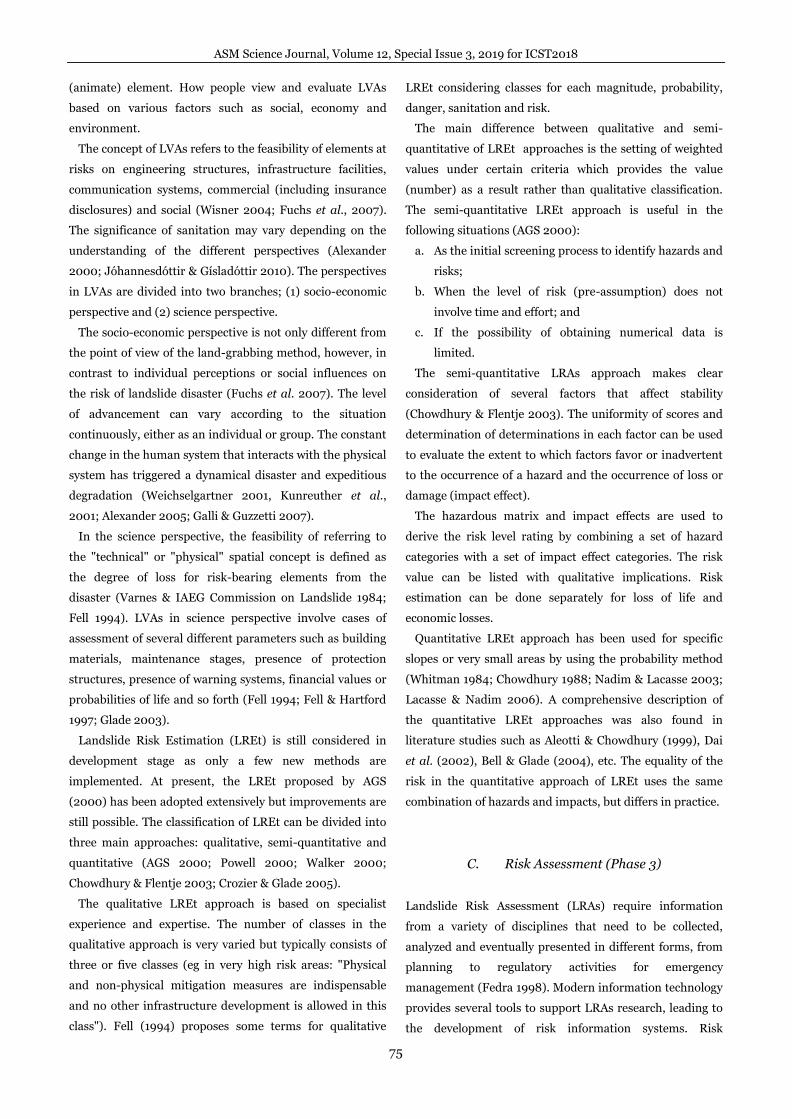
Figure 2 shows the F-N curve used in this study. This
figure has been modified from GEO (1999) according to
local relevance. Based on Figure 2, "acceptable risk" or
"tolerable" refers to a level of risk that does not require any
risk mitigation measures. "Risk that cannot be" accepted
requires proper decision-making of the risk treatment. If
the risk is calculated in the category of "unacceptable risk",
then the risk should be reduced to the "As Low As
Reasonably Practicable" principle (Rodeano, 2018).
Figure 2. Proposed community risk criteria for landslides in
Malaysia (Rodeano, 2018).
The result of the Landslide Risk Evaluation (LREv) will
determine whether the risk is tolerable or tolerant and does
not require any mitigation options, or the risks are not
polarized and require some mitigation alternatives.
Appropriate follow-up reaction should be determined if the
level of risk can be assessed based on its tolerance level.
Figure 3. Risk Evaluation Triangle (RET) to assess the level
of Risk Tolerance Index (RTI) based on fatalities estimation
information (Rodeano, 2018).
A diagram known as "Risk Evaluation Triangle (RET)" is
specially designed in this study to quantify the level of Risk
ASM Science Journal, Volume 12, Special Issue 3, 2019 for ICST2018
77
Tolerance Index (RTI) quantitatively (Figure 3). The
parameters involved in the assessment are "Landslide
Hazard Degree (LHD)" and "Fatalities Estimation (N)". The
intersection of these two parameters will determine the
level of RTI. A detail description and application for RET
has been discussed by Rodeano (2018).
RTI levels will be classified from very low (0.00 - 0.20) to
very high (0.81 - 1.00). The results of the RTI level classes
will determine the degree of tolerance and
recommendations of the Landslide Risk Treatment (LRT)
action to be implemented.
D. Risk Management (Phase 4)
Landslide Risk Management (LRM) involves the following
processes:
a. Landslide Hazard Assessment (LHAs) (Determination
of project scope, Landslide Hazard Identification
(LHI) and Landslide Hazard Analysis (LHAn));
b. Landslide Risk Elements Identification (LREI);
c. Landslide Vulnerability Assessment (LVAs);
d. Landslide Risk Estimation (LREt);
e. Landslide Risk Evaluation (LREv); and
f. Landslide Risk Treatment (LRT).
Landslide Risk Treatment (LRT) is a decision-making
process for managing risk, implementation or enforcement
of risk mitigation measures and revaluation of their
effectiveness from time to time using risk assessment
decisions (ISSMGE 2007; UPC 2011). After the LREv
results are known, the follow-up action is LRT.
LRT involves management principles to reduce the
likelihood of occurrence or adverse effects on humans, daily
activities, property and the environment, and provide
emergency feedback. LRT can be grouped into:
a. Accept risk;
b. Avoid risk;
c. Modifying risk;
d. Reducing the impact of risk;
e. Early monitoring and warning systems;
f. Move risks; and
g. Suspend decision.
The LRT and its design plans are intended to minimize
the risks present in an unavoidable situation. LRT also
involves engineering work aimed at protecting / isolating /
eliminating risky elements from the effects of landslide
hazards and reducing the probability of landslide.
A variety of landslide risk reduction options are
summarized as follows:
a. Hazard modifications: Engineering solutions aim to
alter the features of impact and reduce frequency.
b. Modification of behavior: reducing impact by
avoiding, reducing the level of vulnerability, warning
system, development planning, education, legislation
and financial incentives.
c. Loss sharing: includes insurance systems, disaster
relief, development assistance and compensation.
However, responsibilities for the implementation of
landslide mitigation (including audits and reports) require
ongoing maintenance. Nevertheless, it should be recognized
that there may be situations where development is not
permitted and requires detailed investigation.
The LRT technique involves two major approaches,
reducing the driving moment and increasing the
momentum of the retainer. Reduced driving moment
approach involves: shear stress reduction acting along the
plane plane failure. Example. avoiding incidents; and b. The
shear stress transfer from the basic or anchored elements to
stable slope formation. For example, construction of
retaining structures, structural strengthening, closing
plants and bio-engineering applications.The approach to
enhancing the moment of arrest involves:
a. An increase in the number and effective normal stress
acting along the plane of the failure surface such as
structural strengthening;
b. Reduction of pore pressure measurement such as
surface and drainage protection as well as sub-surface
drainage; and
c. Increased strength of slab material such as
consolidation or soil treatment techniques.
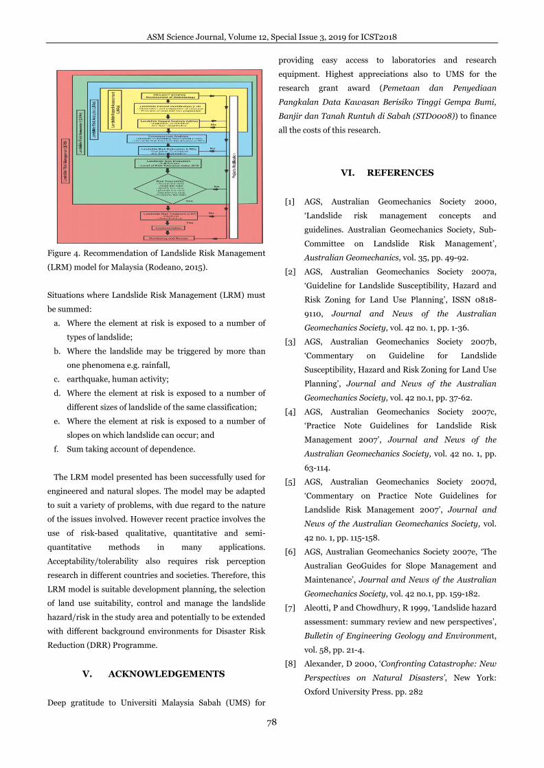
IV. CONCLUSION
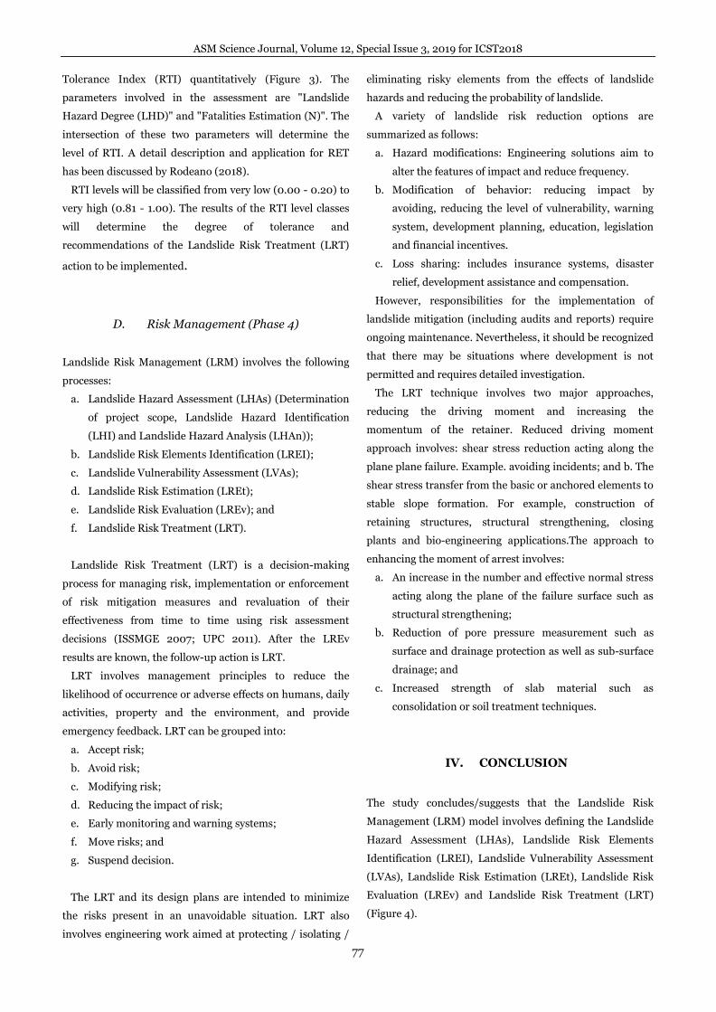
The study concludes/suggests that the Landslide Risk
Management (LRM) model involves defining the Landslide
Hazard Assessment (LHAs), Landslide Risk Elements
Identification (LREI), Landslide Vulnerability Assessment
(LVAs), Landslide Risk Estimation (LREt), Landslide Risk
Evaluation (LREv) and Landslide Risk Treatment (LRT)
(Figure 4).
ASM Science Journal, Volume 12, Special Issue 3, 2019 for ICST2018
78
Figure 4. Recommendation of Landslide Risk Management
(LRM) model for Malaysia (Rodeano, 2015).
Situations where Landslide Risk Management (LRM) must
be summed:
a. Where the element at risk is exposed to a number of
types of landslide;
b. Where the landslide may be triggered by more than
one phenomena e.g. rainfall,
c. earthquake, human activity;
d. Where the element at risk is exposed to a number of
different sizes of landslide of the same classification;
e. Where the element at risk is exposed to a number of
slopes on which landslide can occur; and
f. Sum taking account of dependence.
The LRM model presented has been successfully used for
engineered and natural slopes. The model may be adapted
to suit a variety of problems, with due regard to the nature
of the issues involved. However recent practice involves the
use of risk-based qualitative, quantitative and semi-
quantitative methods in many applications.
Acceptability/tolerability also requires risk perception
research in different countries and societies. Therefore, this
LRM model is suitable development planning, the selection
of land use suitability, control and manage the landslide
hazard/risk in the study area and potentially to be extended
with different background environments for Disaster Risk
Reduction (DRR) Programme.
V. ACKNOWLEDGEMENTS
Deep gratitude to Universiti Malaysia Sabah (UMS) for
providing easy access to laboratories and research
equipment. Highest appreciations also to UMS for the
research grant award (Pemetaan dan Penyediaan
Pangkalan Data Kawasan Berisiko Tinggi Gempa Bumi,
Banjir dan Tanah Runtuh di Sabah (STD0008)) to finance
all the costs of this research.
VI. REFERENCES
[1] AGS, Australian Geomechanics Society 2000,
‘Landslide risk management concepts and
guidelines. Australian Geomechanics Society, Sub-
Committee on Landslide Risk Management’,
Australian Geomechanics, vol. 35, pp. 49-92.
[2] AGS, Australian Geomechanics Society 2007a,
‘Guideline for Landslide Susceptibility, Hazard and
Risk Zoning for Land Use Planning’, ISSN 0818-
9110, Journal and News of the Australian
Geomechanics Society, vol. 42 no. 1, pp. 1-36.
[3] AGS, Australian Geomechanics Society 2007b,
‘Commentary on Guideline for Landslide
Susceptibility, Hazard and Risk Zoning for Land Use
Planning’, Journal and News of the Australian
Geomechanics Society, vol. 42 no.1, pp. 37-62.
[4] AGS, Australian Geomechanics Society 2007c,
‘Practice Note Guidelines for Landslide Risk
Management 2007’, Journal and News of the
Australian Geomechanics Society, vol. 42 no. 1, pp.
63-114.
[5] AGS, Australian Geomechanics Society 2007d,
‘Commentary on Practice Note Guidelines for
Landslide Risk Management 2007’, Journal and
News of the Australian Geomechanics Society, vol.
42 no. 1, pp. 115-158.
[6] AGS, Australian Geomechanics Society 2007e, ‘The
Australian GeoGuides for Slope Management and
Maintenance’, Journal and News of the Australian
Geomechanics Society, vol. 42 no.1, pp. 159-182.
[7] Aleotti, P and Chowdhury, R 1999, ‘Landslide hazard
assessment: summary review and new perspectives’,
Bulletin of Engineering Geology and Environment,
vol. 58, pp. 21-4.
[8] Alexander, D 2000, ‘Confronting Catastrophe: New
Perspectives on Natural Disasters’, New York:
Oxford University Press. pp. 282
ASM Science Journal, Volume 12, Special Issue 3, 2019 for ICST2018
79
[9] Alexander, D 2005, ‘Vulnerability to landslides’,
Glade, T., Anderson, M. & Crozier M. J. (eds.).
Landslide hazard and risk. John Wiley & Sons, Ltd.,
Chichester, West Sussex. pp. 175-198.
[10] Bell, R and Glade, T 2004, ‘Quantitative risk analysis
for landslides – Examples from Bíldudalur, NW-
Iceland’, Natural Hazards and Earth System
Sciences, vol. 4, pp. 117-131.
[11] Bell, R, Glade, T and Danscheid, M 2004,
‘Challenges in defining acceptable risk levels’
Ammann, W & Dannemann, S (eds.). Coping with
Risks Due to Natural Hazards in the 21st Century:
"RISK 21". vol. 28. September-03. December 2004.
Balkema, Monte Vérita (CH), pp. 1-10.
[12] Bell, R, Glade, T and Danscheid, M 2005, ‘Risks in
defining acceptable Risk Levels’, Oldrich H., Fell, R.,
Coulture, R. & Eberhardt, E. (eds.). International
Conference on Landslide Risk Management. 31 May
- 03 June 2005. Balkema, Vancouver, Canada. pp. 7.
[13] Castellanos Abella, EA 2008, ‘Multi-scale landslide
risk assessment in Cuba’, PhD Thesis, International
Institute for Geo-information Science and Earth
Observation, Enschede, The Netherlands.
[14] Chowdhury, RN 1988, ‘Special lecture: analysis
methods for assessing landslide risk – recent
developments’, Bonnard, C (eds.), Proc 5th
International Symposium on Landslides,
Rotterdam: A.A Balkema, Lausanne. pp. 515-524.
[15] Chowdhury, R and Flentje, P 2003, ‘Role of slope
reliability analysis in landslide risk management’,
Bulletin of Engineering Geology and Environment,
vol. 62, pp: 41-46.
[16] Corominas, J, Copons, R, Vilaplana, JM, Altimir, J
and Amigo, J 2003, ‘Integrated Landslide
Susceptibility Analysis and Hazard Assessment in
the Principality of Andorra’, Natural Hazards, vol.
30, pp. 421–435.
[17] Crozier, MJ 2010, ‘Deciphering the effect of climate
change on landslide activity: A review’,
Geomorphology, vol.124, pp. 260–267.
[18] Crozier, MJ and Glade, T 2005, ‘Landslide Hazard
and Risk: Issues, Concepts and Approach’, In Glade,
T, Anderson, M & Crozier, MJ, Landslide Hazard
and Risk, West Sussex: John Wiley & Sons Ltd. pp.
1-40.
[19] Dai, FC, Lee, CF and Ngai, YY 2002, ‘Landslide risk
assessment and management: an overview’,
Engineering Geology, vol. 64, pp: 65–87.
[20] Einstein, HH 1988, ‘Special lecture: Landslide risk
assessment procedure’, Bonnard, C. (eds.), Proc. 5th
International Symposium on Landslides, Publ.
Rotterdam: A.A Balkema, Lausanne. pp. 1075-1090.
[21] Fedra, K 1998, ‘Integrated risk assessment and
management: Overview and State of the Art’,
Journal of Hazardous Material, vol. 61 no. 1-3, pp.
5-22.
[22] Fell, R 1994, ‘Landslide risk assessment and
acceptable risk’, Canadian Geotechnical Journal,
vol. 31, pp. 261-272.
[23] Fell, R 1995, ‘Landslides in Australia’. Bell, D (eds.),
Landslides. Proc. of 6th International Symposium
on Landslides, Christchurch. Balkema, Rotterdam,
ISBN 90 5410032 X.
[24] Fell, R and Hartford, D 1997, ‘Landslide risk
management’, Cruden, D.M. & Fell, R. (eds.),
Landslide risk assessment – Proc. of the Workshop
on Landslide Risk Assessment, Honolulu, Hawaii,
USA, 19-21 February 1997. Rotterdam, A.A.
Balkema: pp. 51-109.
[25] Fell, R, Ho, KKS, Lacasse, S and Leroi, E 2005, ‘A
framework for landslide risk assessment and
management’, Hungr, O, Fell, R, Couture, R &
Eberthardt, E (eds.), Landslide Risk Management,
Taylor and Francis, London. pp. 3–26.
[26] Finlay, PJ and Fell, R 1997, ‘Landslides: Risk
perception and acceptance’, Canadian Geotechnical
Journal, vol. 34, pp. 169-88.
[27] Fischhoff, B, Lichtensetin, BS, Slovic, P, Derby, SL
and Kenney, RL 1981, ‘Acceptable Risk’, Cambridge:
Cambridge University Press.
[28] Fuchs, S, Heiss, K and Hubl, J 2007, ‘Towards an
emprocal vulnerability function for use in debris
flow risk assessment’, Natural Hazards Earth
System Science, vol. 7, pp. 495-506.
[29] Galli, M and Guzzetti, F 2007, ‘Landslide
vulnerability criteria: A case study from Imbria,
Central Italy’, Environmental Management, vol. 40,
pp. 649-664.
[30] GEO, Geotechnical Engineering Office 1999,
‘Landslides and Boulder Falls from Natural Terrain:
Interim Risk Guidelines’, GEO Report 75,
ASM Science Journal, Volume 12, Special Issue 3, 2019 for ICST2018
80
Geotechnical Engineering Office, Civil Engineering
Department, Government of the Hong Kong SAR.
[31] Glade, T 2003, ‘Vulnerability assessment in
landslide risk analysis’, Die Erde, vol. 134, pp. 123–
146.
[32] Guzzetti, F 2002, ‘Landslide Cartography, Hazard
Assessment and Risk Evaluation: Overview, Limits
and Prospective’, Proc. of 3rd MITCH Workshop
Floods, droughts and landslides who plans, who
pays, Potsdam, Germany.
http://geomorphology.irpi.cnr.it/publications/repos
itory/public/proceedings/2002/
[33] Ho, K, Leroi, E and Roberds, B 2000, ‘Quantitative
risk assessment. Application, myths and future
directions’, GeoEng 2000, Technomic Publishing,
pp. 269-312.
[34] Hufschmidt, G, Crozier, M and Glade, T 2005,
‘Evolution of natural risk: research framework and
perspectives’, Natural Hazards and Earth System
Sciences, vol. 5, pp. 375-387.
[35] IAEG, International Association of Engineering
Geology-Commission on Landslides 1990,
‘Suggested nomenclature for landslides’, Bull. of the
International Association of Engineering Geology,
vol. 41, pp. 13-16.
[36] ICG, International Centre for Geohazards 2003,
‘Risk assessment’, Basic terms for landslides.
Norway: ICG. pp. 32
[37] ISSMGE, International Society of Soil Mechanics
and Geotechnical Engineering 2007, TC304
Engineering Practice of Risk Assessment &
Management: Glossary Terms.
www.engmath.dal.ca/tc32.
[38] IUGS-Working Group on landslide 1995, ‘A
suggested method for describing the rate of
movement of a landslide’, Bulletin of the
International Association of Engineering Geology,
vol. 52, pp. 75-78.
[39] IUGS Working Group on Landslides, Committee on
Risk Assessment 1997, ‘Quantitative Risk
Assessment for Slopes and Landslides – the State of
the Art’, In Cruden, DM and Fell, R (eds.), Landslide
Risk Assessment, Balkema, Rotterdam, The
Netherlands, pp. 3–12.
[40] IUGS-Working Group on landslide 2001, ‘A
suggested method for reporting landslide remedial
measures’, Bulletin of Engineering Geology and
Environment, vol. 60, pp. 69-74.
[41] JTC-1 2008, ‘Guidelines for landslide susceptibility,
hazard and risk zoning for land use planning’, In R.
C.-1. Fell, R (eds.), Engineering Geology, vol. 102,
pp. 83-84.
[42] Jóhannesdóttir, G, and Gísladóttir, G 2010, ‘People
living under threat of volcanic hazard in southern
Iceland: vulnerability and risk perception’, Natural
Hazards Earth System Science, vol. 10, pp. 407–
420.
[43] Kunreuther, H, Novemsky, N, and Kahneman, D
2001, ‘Making low probabilities useful’, Journal of
Risk Uncertainty, vol. 23, pp. 103–120.
[44] Lacasse, S and Nadim, F 2006, ‘Hazard and risk
assessment of slopes’, Proc. of the International
Concerence on Slope, Malaysia 2006, Kuala
Lumpur, pp.1-26.
[45] Lee, EM & Jones, DKC 2004, ‘Landslide risk
assessment’, Thomas Telford: London, pp. 454
[46] Morgenstern, NR 1997, ‘Toward landslide risk
assessment in practice’, Landslide Risk Assessment,
pp. 15-23.
[47] Nadim, F and Lacasse, S 2003, ‘Review of
probabilistic methods for quantification and
mapping of geohazards’, Geohazards 2003, pp. 279-
286
[48] NRC, National Research Council, Transportation
Research Board 1996, ‘Landslides Investigation and
Mitigation’, Special Report, vol. 247, pp. 673.
[49] Powell, G 2000, ‘Discussion "landslide risk
management concepts and guidelines"’, Australian
Geomechanics, vol. 35 no. 3, pp. 105-110.
[50] Roberds, WJ 2001, ‘Quantitative landslide risk
assessment and management’, Proceedings of
International Conference on Landslides - Causes,
Impacts and Countermeasures, pp. 585-595.
[51] Roslee, R 2018, ‘Risk Evaluation Triangle (RET) For
Landslide Risk Management (LRM): A Case Study
from Kota Kinabalu, Sabah, Malaysia’, ASM Sci. J.
11: Special Issue 2018(3) for SANREM (Environmental
Management), pp: 206-214.
[52] Roslee, R 2015, ‘Model Development of Landslide
Risk Management: Case study from Kota Kinabalu,
Sabah, Malaysia’, PhD Thesis, Universiti
Kebangsaan Malaysia.
ASM Science Journal, Volume 12, Special Issue 3, 2019 for ICST2018
81
[53] UNESCO-WP/WLI 1993, ‘A suggested method for
describing the activity of a landslide’, Bulletin of the
International Association of Engineering Geology,
vol. 47, pp. 53-57.
[54] UNESCO-WP/WLI 1993, ‘Multilingual Landslide
Glossary’, Bitech Publishers Ltd, Richmond, pp. 34
[55] UNESCO-WP/WLI 1994, ‘A suggested method for
reporting landslide causes’, Bulletin of International
Association of Engineering Geology, vol. 50, pp. 71-
74.
[56] UPC, Technical University of Catalonia 2011,
‘Guidelines for landslide susceptibility, hazard and
risk assessment and zoning’, pp. 173
[57] Varnes, DJ 1978, ‘Slope movements types and
processes’, In Schuster, RL and Krizek, RL (eds.),
Landslides: Analysis and Control. Special Report
176, pp. 11-33.
[58] Varnes DJ and IAEG Commission on Landslide
1984, ‘Landslide hazard zonation - a review of
principles and practise’, Paris: UNESCO.
[59] van Westen, CJ, Van Asch, TWJ and Soeters, R
2006, ‘Landslide hazard and risk zonation - why is it
still so difficult?’, Bulletin of Engineering Geology
and the Environment, vol. 65, pp. 167–184.
[60] Walker, BF 2000, ‘Response to discussion by Powell,
G’, Australian Geomechanics, vol. 35 no. 3, pp. 111-
113.
[61] Weichselgartner, J 2001, ‘Disaster mitigation: the
concept of vulnerability revisited’, Disaster
Prevention and Management, vol. 10, pp. 85–94.
[62] Whitman, RV 1984, ‘ Evaluating calculated risk in
geotechnical engineering’, Journal of Geotechnical
Engineering, vol. 110 no. 2, pp. 145-188.
[63] Wu, TH, Tang, WH and Einstein, HH 1996,
‘Landslide hazard and risk assessment’, In AK
Turner and RL Schuster (Eds), Landslide
Investigation and Mitigation, Transportation
Research Board, National Research Council, pp.
106-128.