bengkel konsultatif pelan sains, teknologi, … · bengkel konsultatif pelan sains, teknologi,...
TRANSCRIPT
BENGKEL KONSULTATIF PELAN SAINS, TEKNOLOGI,
INOVASI BAGI PENGURANGAN RISIKO BENCANA DRR
(STI4DRR)
TAKLIMAT
STI FOR LANDSLIDE HAZARDS
Zamr i Raml i
Jabatan Minera l Dan Geosains Malays ia
ISNIN│24 JULAI 2017 │ 8.30pagi -5.00 Petang
KELAB GOLF DANAU KOTA,UKM BANGI
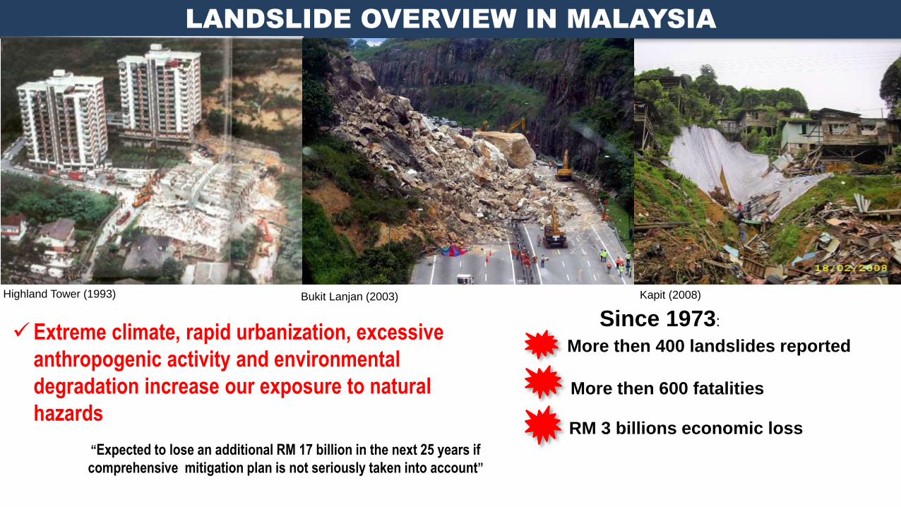
LANDSLIDE OVERVIEW IN MALAYSIA
Highland Tower (1993) Bukit Lanjan (2003)
Since 1973:
More then 400 landslides reported
More then 600 fatalities
RM 3 billions economic loss
Extreme climate, rapid urbanization, excessive
anthropogenic activity and environmental
degradation increase our exposure to natural
hazards
“Expected to lose an additional RM 17 billion in the next 25 years if
comprehensive mitigation plan is not seriously taken into account”
Kapit (2008)
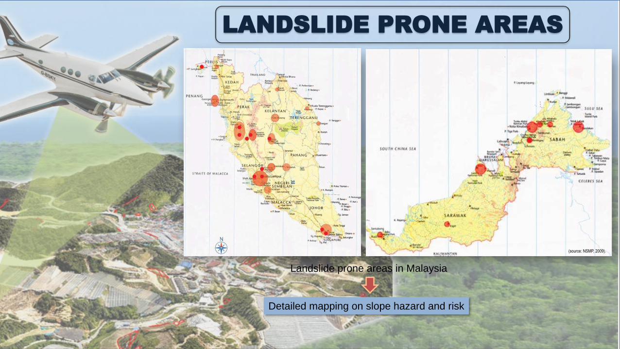
LANDSLIDE PRONE AREAS
Landslide prone areas in Malaysia
Detailed mapping on slope hazard and risk
(source: NSMP, 2009).
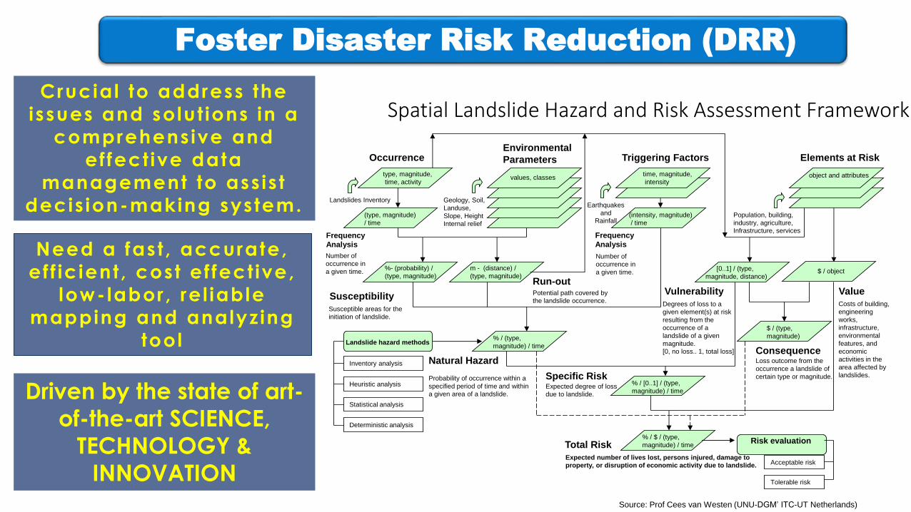
Spatial Landslide Hazard and Risk Assessment FrameworkCrucial to address the
issues and solut ions in a
comprehensive and
ef fect ive data
management to ass is t
decis ion-making system.Population, building,
industry, agriculture,
Infrastructure, services
Landslides Inventory
OccurrenceEnvironmental
Parameters Triggering Factors Elements at Risk
Susceptibility
Natural Hazard
Specific Risk
Total Risk
Vulnerability
Geology, Soil,
Landuse,
Slope, Height
Internal relief
Earthquakes
and
Rainfall
Susceptible areas for the
initiation of landslide.
Probability of occurrence within a
specified period of time and within
a given area of a landslide.Expected degree of loss
due to landslide.
Degrees of loss to a
given element(s) at risk
resulting from the
occurrence of a
landslide of a given
magnitude.
[0, no loss.. 1, total loss]
Expected number of lives lost, persons injured, damage to
property, or disruption of economic activity due to landslide.
type, magnitude,
time, activityvalues, classes
time, magnitude,
intensityobject and attributes
Frequency
Analysis
(type, magnitude)
/ time
Run-outValue
%- (probability) /
(type, magnitude)
% / (type,
magnitude) / time
Frequency
Analysis
(intensity, magnitude)
/ time
$ / object[0..1] / (type,
magnitude, distance)
% / [0..1] / (type,
magnitude) / time
% / $ / (type,
magnitude) / time
Number of
occurrence in
a given time.
Number of
occurrence in
a given time.
Landslide hazard methods
Heuristic analysis
Statistical analysis
Inventory analysis
Deterministic analysis
Consequence
$ / (type,
magnitude)
Loss outcome from the
occurrence a landslide of
certain type or magnitude.
Risk evaluation
Acceptable risk
Tolerable risk
m - (distance) /
(type, magnitude)
Costs of building,
engineering
works,
infrastructure,
environmental
features, and
economic
activities in the
area affected by
landslides.
Potential path covered by
the landslide occurrence.
Source: Prof Cees van Westen (UNU-DGM’ ITC-UT Netherlands)
Need a fast , accurate,
ef f ic ient , cost ef fect ive,
low-labor, re l iable
mapping and analyz ing
tool
Driven by the state of art-
of-the-art SCIENCE,
TECHNOLOGY &
INNOVATION
Foster Disaster Risk Reduction (DRR)
3
1
2
4 5 6 7
8
9
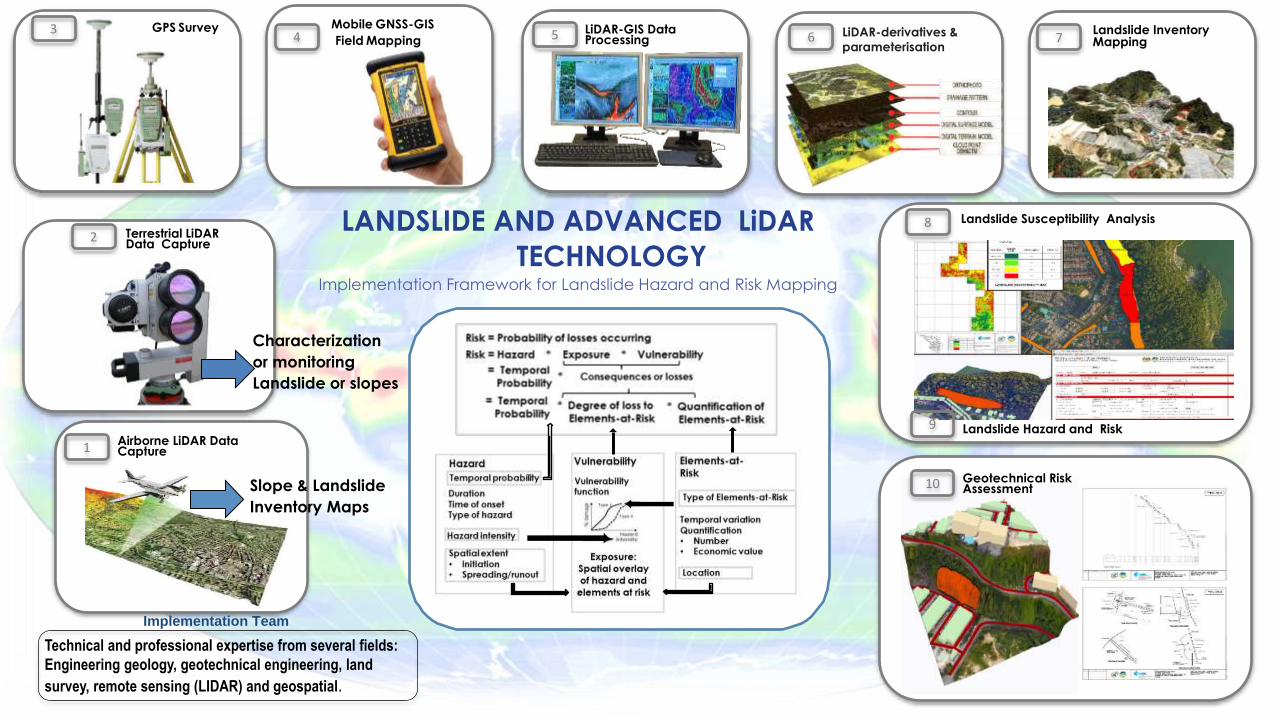
10 Geotechnical Risk Assessment
Landslide Hazard and Risk
Landslide Susceptibility AnalysisLANDSLIDE AND ADVANCED LiDAR
TECHNOLOGYImplementation Framework for Landslide Hazard and Risk Mapping
Landslide Inventory Mapping
LiDAR-derivatives & parameterisation
LiDAR-GIS Data Processing
Technical and professional expertise from several fields:
Engineering geology, geotechnical engineering, land
survey, remote sensing (LIDAR) and geospatial.
Implementation Team
Mobile GNSS-GIS
Field MappingGPS Survey
Terrestrial LiDAR Data Capture
Airborne LiDAR Data Capture
Slope & Landslide
Inventory Maps
Characterization
or monitoring
Landslide or slopes
Gunung PassKg. Raja Blue Valley
Brinchang A
Brinchang B
Kuala Terla
Tringkap
Tanah Rata A
Tanah Rata B
RingletLembah Bertam
PROJEK PBRC CAMERON HIGHLANDS
275 km2
Landslide
Critical Slope
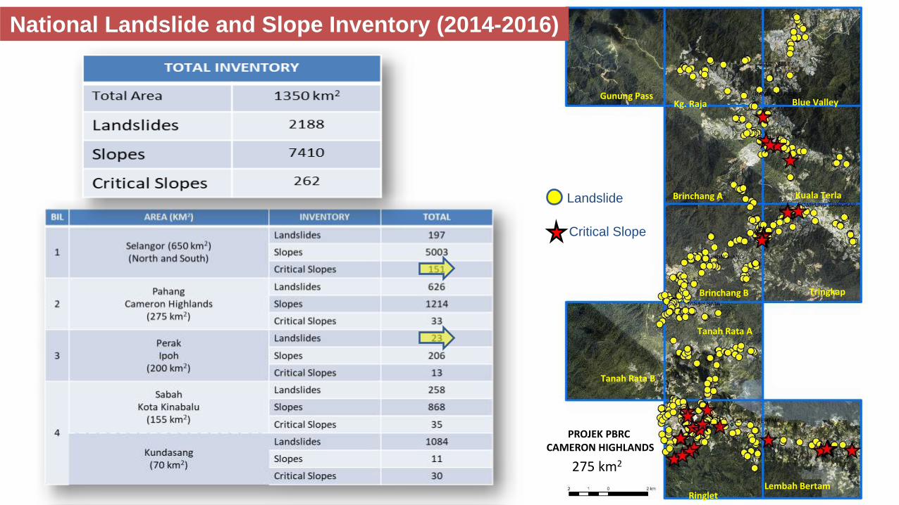
National Landslide and Slope Inventory (2014-2016)
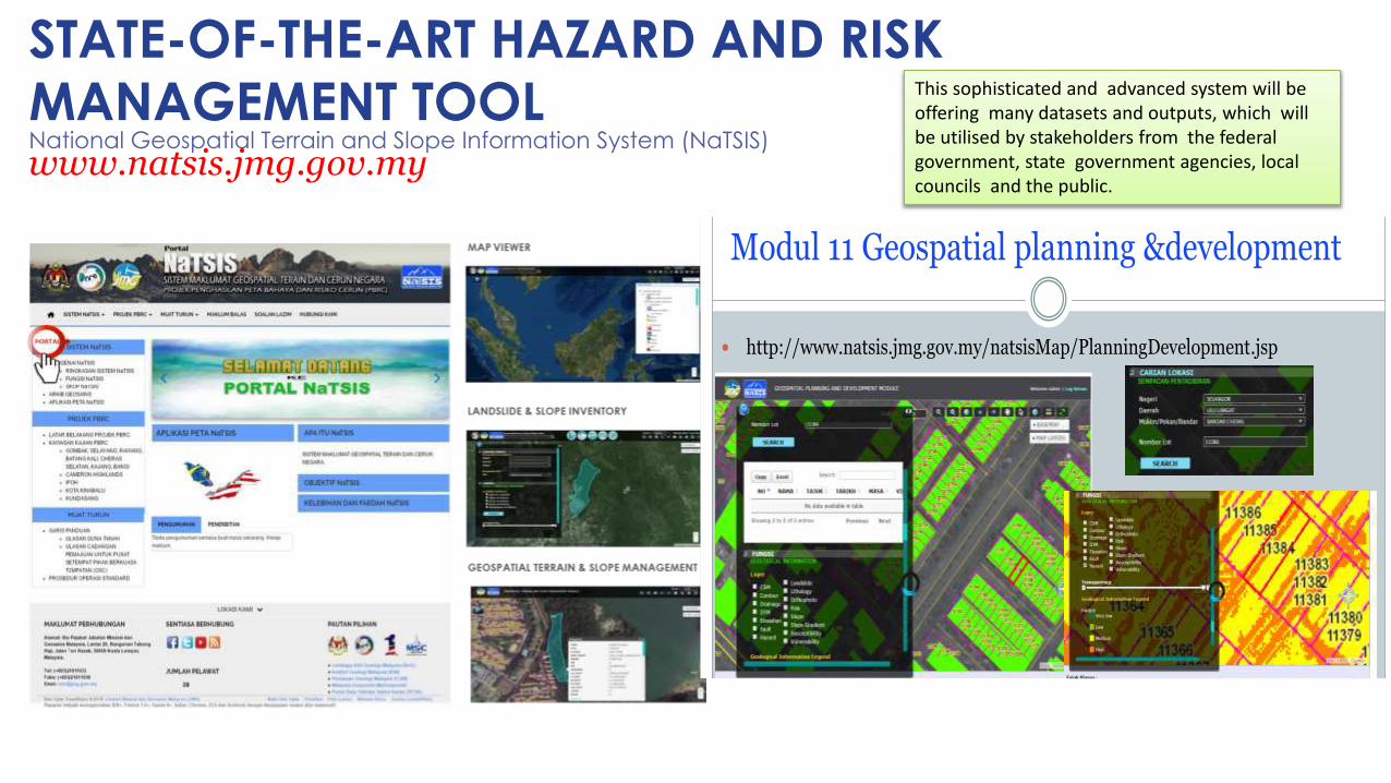
www.natsis.jmg.gov.my
STATE-OF-THE-ART HAZARD AND RISK MANAGEMENT TOOLNational Geospatial Terrain and Slope Information System (NaTSIS)
Taklimat Khas NaTSIS untuk Pengurusan Jabatan, 3 Mei 2017 BPT JMG 43
Modul 11 Geospatial planning &development
http://www.natsis.jmg.gov.my/natsisMap/PlanningDevelopment.jsp
This sophisticated and advanced system will be offering many datasets and outputs, which will be utilised by stakeholders from the federal government, state government agencies, local councils and the public.
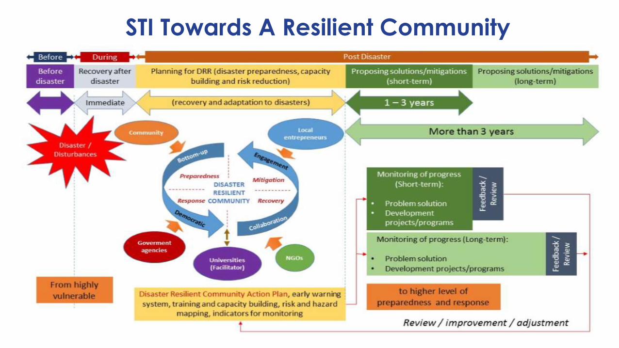
STI Towards A Resilient Community
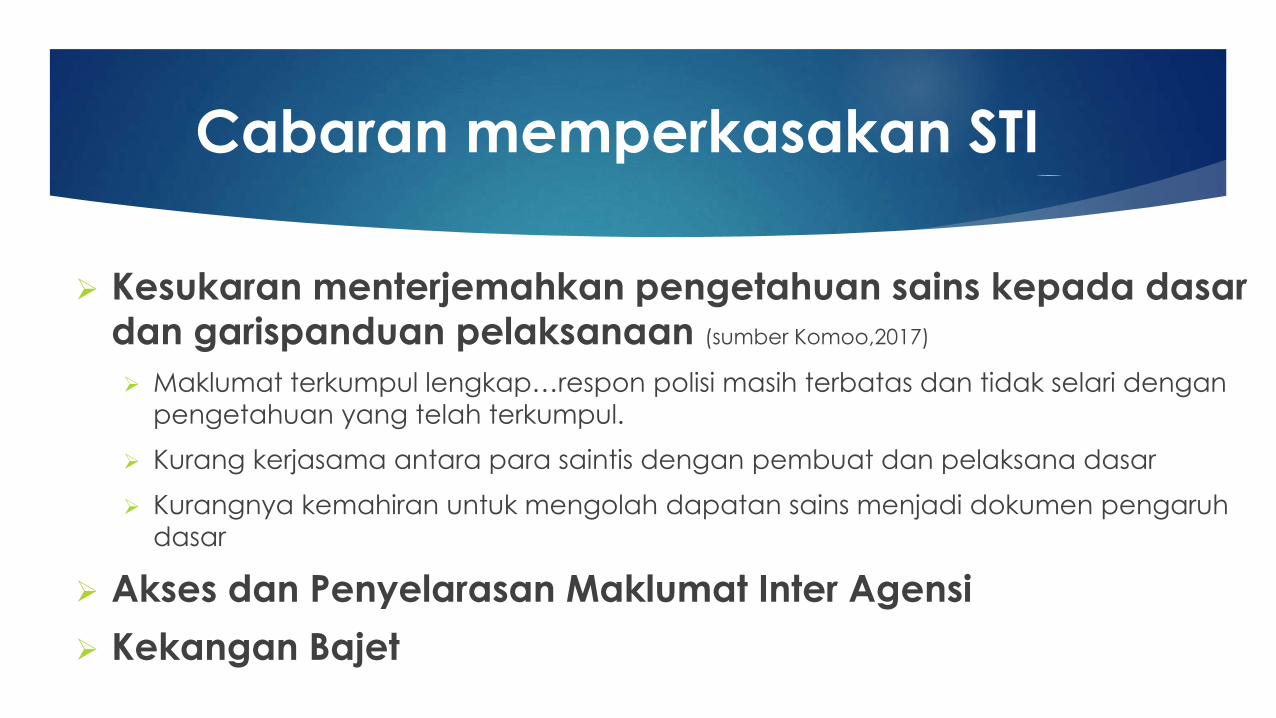
Cabaran memperkasakan STI
Kesukaran menterjemahkan pengetahuan sains kepada dasar
dan garispanduan pelaksanaan (sumber Komoo,2017)
Maklumat terkumpul lengkap…respon polisi masih terbatas dan tidak selari dengan
pengetahuan yang telah terkumpul.
Kurang kerjasama antara para saintis dengan pembuat dan pelaksana dasar
Kurangnya kemahiran untuk mengolah dapatan sains menjadi dokumen pengaruh
dasar
Akses dan Penyelarasan Maklumat Inter Agensi
Kekangan Bajet
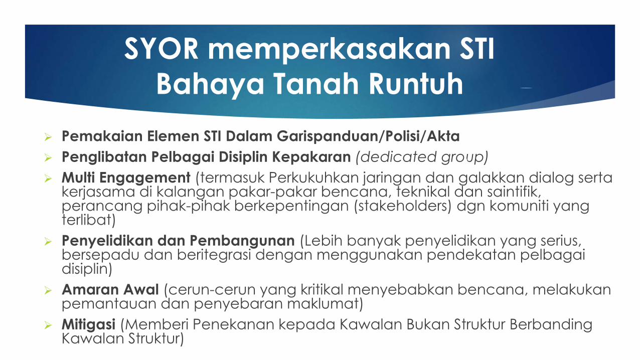
SYOR memperkasakan STI
Bahaya Tanah Runtuh
Pemakaian Elemen STI Dalam Garispanduan/Polisi/Akta
Penglibatan Pelbagai Disiplin Kepakaran (dedicated group)
Multi Engagement (termasuk Perkukuhkan jaringan dan galakkan dialog sertakerjasama di kalangan pakar-pakar bencana, teknikal dan saintifik, perancang pihak-pihak berkepentingan (stakeholders) dgn komuniti yang terlibat)
Penyelidikan dan Pembangunan (Lebih banyak penyelidikan yang serius, bersepadu dan beritegrasi dengan menggunakan pendekatan pelbagaidisiplin)
Amaran Awal (cerun-cerun yang kritikal menyebabkan bencana, melakukanpemantauan dan penyebaran maklumat)
Mitigasi (Memberi Penekanan kepada Kawalan Bukan Struktur BerbandingKawalan Struktur)