exposure of municipal solid waste disposal sites to climate … · 2017-04-28 · exposure of...
TRANSCRIPT
Exposure of municipal solid waste disposal sites to climate related geohazards: Case study of Selangor
Nurul SyazwaNi yahaya1, ChouN-SiaN lim1, mohd raihaN Taha2 & Joy JaCqueliNe Pereira1*
1Southeast Asia Disaster Prevention Research Initiative (SEADPRI), Universiti Kebangsaan Malaysia, 43600 Bangi, Selangor, Malaysia
2Faculty of Engineering, Universiti Kebangsaan Malaysia, 43600 Bangi, Selangor, Malaysia*Corresponding author: [email protected]
Abstract: In the advent of climate change, municipal solid waste (MSW) disposal sites may be exposed to climate-related geohazards such as floods and landslides, which negatively impacts humans and the environment through direct and cascading effects. A preliminary assessment was conducted on landfills and open dumps in Selangor using topographic maps, flood hazard maps, satellite imagery and field investigation. The results reveal that six out of 20 landfill sites in Selangor are highly exposed to the100-year flood while two sites are exposed to slope failure. The exposed sites are currently without any protection measures making populated areas in the vicinity vulnerable to hazards and their cascading impacts. More detailed investigation is required at the exposed sites to plan appropriate mitigation measures.
Keywords: landfill, flooding, waste mass movement, climate change impacts, Selangor
Perubahan iklim dijangka menjadikan tapak pelupusan sisa pepejal perbandaran lebih terdedah kepada bahaya berkaitan iklim seperti banjir dan kegagalan cerun yang boleh memberi impak buruk terhadap manusia dan persekitaran melalui kesan langsung dan berkasked. Penilaian awal terhadap tapak pelupusan dan tapak pembuangan terbuka di Selangor telah dijalankan melalui peta topografi, peta bahaya banjir, imej satelit serta penyiasatan di lapangan tapak pelupusan. Hasil penilaian mendapati bahawa terdapat enam daripada 20 tapak pelupusan yang terdedah kepada bahaya banjir 100-tahun manakala terdapat dua tapak pelupusan yang terdedah kepada bahaya kegagalan cerun. Tapak pelupusan yang terdedah didapati tidak dilengkapi sebarang langkah perlindungan yang menjadikan kawasan berpenduduk di sekitar tapak mudahterancam kepada bahaya dan impak berkasked. Penyiasatan yang lebih terperinci adalah diperlukan di tapak pelupusan yang terdedah bagi perancangan langkah mitigasi yang sesuai.
Kata kunci: tapak pelupusan, banjir, pergerakan jisim sisa, impak perubahan iklim, Selangor
INTRODUCTION Disposal of municipal solid waste (MSW) through
sanitary landfilling and open dumping on land is common across the globe. Sanitary landfilling is predominantly practiced in developed nations while open dumping is common in low-income and developing nations. An open dump is a primitive and non-sanitary waste disposal site where indiscriminate wastes are improperly tipped or dumped in a pre-existing hole or on the side of a hill without proper maintenance (Agamuthu, 2001; Blight, 2008). Alternatively, a sanitary landfill utilizes the principles of engineering to ensure protection of the environment and public health while providing a safe long-term disposal of solid wastes (ASCE, 1959). However, climate-related hazards (referred to as geohazards in this paper) have impacted waste disposal sites causing direct or cascading physical, chemical and biological impacts to nearby population and the environment (Blight, 2008; Young, 2004; Hwang, 2002; Flynn et al., 1984). Geographical, topographical and geological settings are important factors in considering the exposure of sites to the geohazards.
In Malaysia, municipal solid waste is disposed in both the newer sanitary landfills and older open dumps. Generally, the older waste disposal sites are improperly sited and the
status of their exposure to climate-related geohazards is unknown. Climate-related geohazards in the form of floods and landslides are among the predominant natural hazards in Malaysia (EM-DAT, 2014). Floods have affected the highest number of people and caused the highest economic damage compared to other types of disasters in Malaysia within the period of 1980 to 2015 (EM-DAT, 2014). Topographic settings of an area play a crucial role in the exposure of that area to flood hazard (Baker et al., 1988; Gasim et al., 2010). Physical characteristics of drainage basins and stream channels determine the flood flow while the amount and intensity of precipitation influence the magnitude and frequency of flood (Baker et al., 1988). Large floods typically occur following heavy monsoon rainfalls or high tides affecting low-lying areas near major rivers and coastal areas especially on the East coast of Peninsular Malaysia, while flash floods are more common in the urban areas (Gasim et al., 2010; JPS, 2013). In a warmer future climate, an increase in extreme precipitation events is expected to increase the risk of large floods events in a number of major river basins due to high river discharge, including during north east monsoon in the Southeast Asian countries (Meehl et al., 2007, Seneviratne et al., 2012; Christensen et al., 2013). An escalation of extreme sea level has also
Bulletin of the Geological Society of Malaysia, Volume 62, December 2016, pp. 57 – 63
Nurul SyazwaNi yahaya, ChouN-SiaN lim, mohd raihaN Taha & Joy JaCqueliNe Pereira
Bulletin of the Geological Society of Malaysia, Volume 62, December 201658
been observed, which may exacerbate the intensity and frequency of flooding in coastal floodplains (Meehl et al., 2007; Nicholls, 2002). These conditions will increase the frequency and exposure to flood hazards for sites located on low-lying areas of floodplains and coastal plains.
Incidentally an increase of extreme precipitation events under the effect of climate change is expected to intensify slope processes (Crozier, 2010). Hence waste disposal sites located on steep terrain or on hill slopes are subject to an increasing risk of landslides associated with climate extremes. Structural or slope failures of disposal sites following heavy or prolonged precipitation events had occurred in a number of cases (Blight, 2008). Waste slope failures can occur when the shear strength of the wastes becomes lower than the shear stress, due mostly to lack of technical control at the sites. This includes unrestrained piling up of wastes on an already steep face and lack of compaction of the wastes, among other contributing factors. Although in many cases the process are often exacerbated by extreme weather events. In the absence of cover layer, infiltrated moisture from precipitation has the ability to increase shear stress by adding weight to the slope. Moisture can also reduce the frictional contact between slope materials thus significantly lowering the angle of repose. Indication of static liquefaction has been observed in several cases of flow failures at waste disposal sites attributable to high pore water pressure condition through wastes or soils materials (Blight, 2008).
At present, investigation related to geohazards such as flooding and slope failures at waste disposal sites is limited in Malaysia although occurrences have been reported in scientific and non-peer reviewed literatures. In the advent of climate change coupled with urbanization that often drives expansion of settlements into areas at risk, it becomes more critical to identify the exposure and examine the possible direct and cascading effects on the surrounding environment and population. The paper provides a general review of potential hazards based on previously reported cases of harmful events at waste disposal sites. The findings of a preliminary assessment to identify sites that are endangered to floods and slope failures in Selangor is also reported. Recognizing the exposure of waste disposal sites to geohazards is a crucial initial step to reduce the risk of disasters and ensure the sustainability of the surrounding population and environment in a changing climate.
METHODOLOGYThe study commenced with a general review of
geohazards and landfills as well as the conditions in Selangor. This was followed by a preliminary assessment of landfill sites using spatial-proximity analysis, satellite imageries and field investigation to evaluate exposure to floods and landslide hazards.
Since most of the flood prone areas are found within the 100-year flood area, the proximities of landfill for horizontal distance were measured to the boundary of 100-year flood. Relevant recent sites information on operating and closed landfills are collected from the National Solid
Waste Management Department website (JPSPN, 2013), a report by the Town and Country Planning Department (JPBD, 2012), review of studies by Suratman & Sefie (2010) and site visits. The flood prone map and statistical 100-year recurrent interval flood map are from the Drainage and Irrigation Department (JPS), published in the 2nd National Physical Plan (JPBD, 2010). The statistical recurrence interval of 100-year flood map represents a large flood event. Using GIS, the flood prone and 100-year flood maps are overlaid on the Digital Elevation Model of Selangor with superimposed landfills distribution. Flood risk exposures are assigned based on distance from flood prone areas. Land elevation difference of the landfills to flood boundary were measured to estimate the potential depth of 100-year flood relative to the landfills, assuming the floodwater is flat boundary to boundary. Observation for potential cascading hazards at the exposed sites was made based on the land-use surrounding the landfills during the field investigation using land-use maps and satellite imageries (Google Earth).
Landfill exposure to slope failure was screened based on terrain topography and natural slope relief. Identification of the potentially exposed landfills was made using topographic map to find sites that are located above or close to topographic elevation of 100 meter. This was then followed by field investigation of the potential sites. In Selangor, wastes deposited on the slopes are not compacted or covered and is expected to have low shear strength (leading to mass movement of wastes). Based on the assumption of low shear strength, sites located on natural slope with slope angle of more than 30o are categorized as endangered to the risk of slope failure. Observation for potential cascading hazards at the exposed sites was made based on the land-use surrounding the landfills during field investigation using land-use maps as well as satellite imageries (Google Earth).
CASCADING EFFECTS OF GEOHAZARDS AT DISPOSAL SITES
Municipal solid waste disposal sites are a source of environmental hazard that could bring adverse effects on humans and surrounding ecosystems. Significant pollutants emission in the form of leachate and gases to air, water resources and soil can persevere for centuries after sites closure until they are compatible with the environment (Belevi & Baccini, 1989). Hazardous organic and inorganic substances and disease vectors from waste disposal sites endanger the health of people exposed by direct contact including through inhalation or ingestion (El-Fadel, 1997; Agamuthu, 2001; Yong et al., 2007; Giusti, 2009). Review of literatures on waste disposal facilities disrupted by geohazards has revealed pervasive cascading effects on physical environment, public health, waste management as well as the economy. The cascading effects include direct, indirect, and long term interconnected failures that propagate in a cascade of cause and effect chain sequence (May, 2007; Pescaroli & Alexander, 2014). Vulnerability of the exposed subjects is the main attribute of the propagation of the cascade as repeatedly observed in disaster events
ExposurE of municipal solid wastE disposal sitEs to climatE rElatEd gEohazards: casE study of sElangor
59Bulletin of the Geological Society of Malaysia, Volume 62, December 2016
involving critical infrastructures (Van Eeten, 2011; Pescaroli & Alexander, 2014).
Extreme rainfall or storms events at waste disposal sites followed by severe rupture of slopes had caused off-site wastes flow endangering lives and surrounding environment (Blight 2008; Hwang, 2002). Catastrophic effects can be expected from sites with large volume of waste unsafely piled on hillslopes and where developed and residential areas are nearby. In this type of condition, severe direct impacts can include loss of lives, injuries and property damages (Blight, 2008; Hwang, 2002). Waste flow also caused blockage of rivers and released great amount of pollutants off-site that resulted in severe environmental degradation. In China, failure of landfills to operate during disaster events had resulted in waste management crisis where large amount of waste were left piling on sideways (Hwang, 2002). The wastes piles congested the road and had led to traffic problems. In addition, poor hygiene due to the crisis brought about hazard to public health. During storms, greater amount of wastes were also being produced that aggravated the crisis.
Although direct casualty is not recorded from any flood case history at waste disposal sites in the low-lying areas, the ensuing cascading effects the including the long term effects are no less insidious. The impacts of riverine flood and coastal flood during storm at waste disposal sites include physical erosion, inundation, waste solution migration and saltwater intrusion (Laner et al., 2008; Flynn, 1984; Curtis & Whitney, 2003). Flood erosion especially from long duration floods could damage the infrastructures of waste disposal sites even those that are protected against flooding (Curtis & Whitney, 2003). In addition, high moisture content and high moisture flow condition during flood inundation can enhance waste decomposition and increases leachate flux and pollutant emission (Klink & Ham, 1982). Waste materials mobilized downstream by floodwater will be deposited along its flow path including on residential properties as flood receded that result in widespread environmental pollution (Flynn et al., 1984; Young, 2004; Laner et al., 2009). The impacts from periodic flooding events at landfills that pollute surface soils on floodplain may persevere for a long time. Heavy metal contamination of floodplain soils may bring potential health risk to river bank inhabitants who consume crops grown from the contaminated soils (Albering, 1999). In longer term, contaminated sediments deposited at the surface could significantly pollute the subsoil and groundwater through the process of leaching and endanger the groundwater resources in the affected areas (Rudis et al., 2009).
Storm and floodwater flowing through a waste disposal site could also become a source of biological hazards such as pathogenic bacteria that are transmitted from the site to a wider environment. Infection to humans is common as they come into direct contact with the contaminated floodwater. Bacterial infection may cause diarrhea, fever, cramps, vomiting and other diseases that result in public health risks. In the worst cases, infection to pathogenic
bacteria can lead to fatalities. During a large flood event in the City of Olongopo, Philippines, eleven fatalities were reported due to leptospirosis outbreak and over 400 people were infected with the disease. The incident was attributed to possible contact of storm water to a rat-infested dumpsite where the pathogens were derived before flowing into the city during the flood (Randy, 2013). Leptospirosis and other bacterial infection from floodwater are common public health risks in developing countries including Malaysia especially during the monsoon season.
In coastal areas, additional threats to coastal landfills due to sea level rise include increasing risk of damage from exacerbated storm flooding and erosion, inundation of lowland, saltwater intrusion and changes in water table (Bjilsma et al., 1996). Higher storm surges enables waves to move further inland and stronger wave action. Within a longer time span, significant shoreline retreat can move surf zone closer to waste site (Flynn et al., 1984). Saline intrusion and the rise of water table may also corrode and disrupt the capability of clay liners (Flynn et al., 1984). Cascading effects from subsequent pollution in the coastal areas may include disruption to marine ecosystem and possibly socio-economic impacts to local people.
Many active landfills previously affected by disaster events failed to recover from the damages and were forced to close down earlier than the expected usage life (Hwang, 2002). Reduction to the lifetime of landfills can be a critical issue especially for the urban areas that are facing land scarcity to construct new landfills (Agamuthu & Fauziah, 2011). Additionally, recovery fees and compensation expenses including relief funds are often costly and may cause a substantial distress on the local economy (Hwang, 2002). These costs may eventually result in the increase of economic burden to the affected regions.
EXPOSURE OF MUNICIPAL SOLID WASTE DISPOSAL SITES IN SELANGOR
Waste Disposal Sites in SelangorSelangor is the most developed state in Malaysia and
produces the highest MSW per capita owing to the high standard of living (Leete, 2005; Agamuthu, 2001). With ever growing economic activities and increasing population, the challenge to manage solid wastes in the urban regions of Selangor becomes greater. In Malaysia, proper disposal of solid waste at sanitary landfills constitute only a small portion and were built recently compared to open dumps which constitute around 90% of all the waste disposal sites (Agamuthu & Fauziah, 2011; Sharifah & Latifah, 2013). Landfills of both sanitary and open dumps in Selangor are classified into several different levels as follows (Department of Local Government, 2006): Level 0: Open dumping.Level I: Controlled tipping.Level II: Sanitary landfill with a bund and daily soil cover.Level III: Sanitary landfill with leachate recirculation system. Level IV: Sanitary landfill with leachate treatment facilities.
Nurul SyazwaNi yahaya, ChouN-SiaN lim, mohd raihaN Taha & Joy JaCqueliNe Pereira
Bulletin of the Geological Society of Malaysia, Volume 62, December 201660
Currently, there are a total 20 landfill sites in Selangor, six of which are operating and the rest already closed. Only four sites are classified as sanitary landfills (three with Level IV and one Level II) and the rest are classified as dump sites (Level 0 and Level 1). In addition to the landfills, Selangor also has one Refuse Derived Fuel (RDF) plant located in Semenyih that is being used to dispose MSW from the Municipality of Kajang. Information on open dumpsites is scarce as these sites were built prior to the Environmental Impact Assessment (EIA) implementation in 1987. However various studies reveal very high contaminants levels in the groundwater underneath the non-engineered waste disposal sites in Selangor (Bahaa-eldin et al., 2010; Taha et al., 2011; Suratman & Sefie, 2010). The subsurface soils were considerably polluted by heavy metals where wastes were dumped directly on top of unlined natural formation (Mohd et al., 2013). These poorly equipped waste disposal sites are more susceptible when subjected to geohazards due to total absence or the lack of protection measures. Unengineered active sites are particularly most vulnerable.
Limited literatures were found for cases involving geohazards at the landfills in Selangor. One of the cases includes a flooding event at Kundang landfill situated about 10 meters from Kundang River. The river overspill following a heavy rainfall had inundated the landfill area and disabled waste disposal activity. The waste dumping crisis had resulted in a dispute among the waste management parties (Suryani, 2001). Another case of flooding was revealed indirectly based on a groundwater quality study at Ampar Tenang landfill. Groundwater contamination had been observed upstream of the landfill which can be reasonably explained by flooding events in the past that would be able to mobilize the contaminants from the landfill located downstream (Bahaa-eldin et al., 2010). A dump landslide located at 200 m topographical height had been reported at an illegal dumping site at Seri Gombak site close to a village on September 2013 after prolonged rainfall event. The slides from the top of a hill slope occurred in a very close proximity to the neighborhood area, endangering the lives of 300 villagers living near the hillslope. The wastes also flowed into a small river nearby the area and blocked the stream (Norafiza, 2013). These types of failure cases at landfill sites that are exposed to geohazards can have severe environmental pollution consequences if the sites remain unmitigated. Although only three cases were discovered from available literatures, there may be others that possibly went unreported especially when involving closed landfills and dumpsites in rural parts of Selangor. A systematic analysis will facilitate ranking of the level of exposure in order to take proper actions.
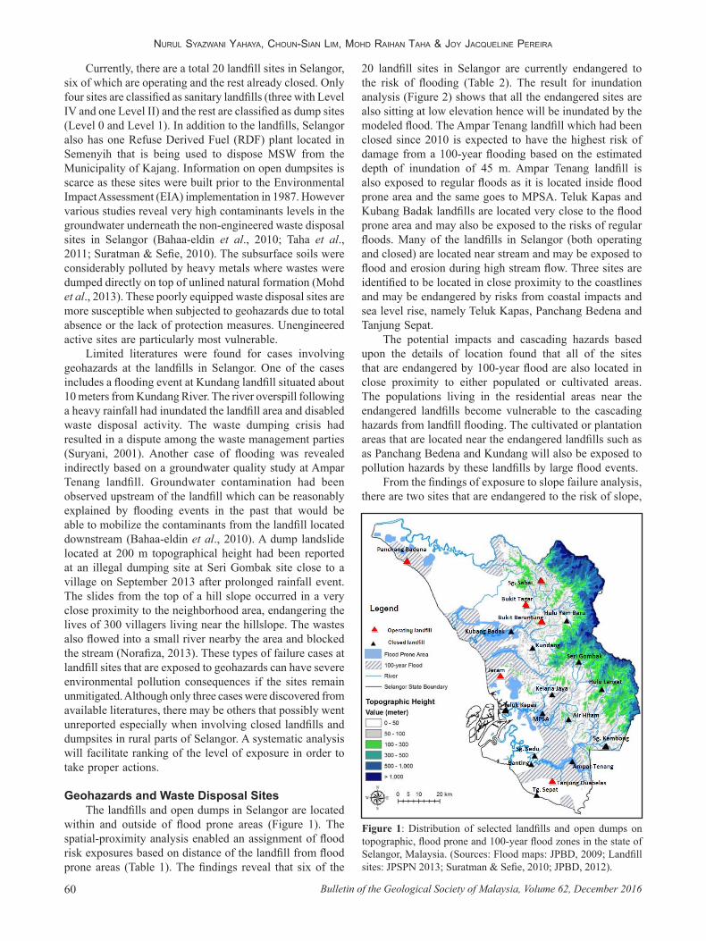
Geohazards and Waste Disposal SitesThe landfills and open dumps in Selangor are located
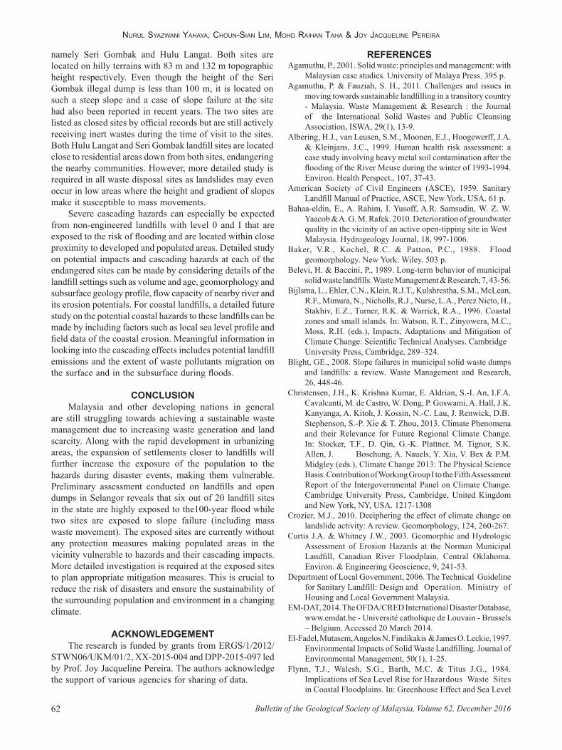
within and outside of flood prone areas (Figure 1). The spatial-proximity analysis enabled an assignment of flood risk exposures based on distance of the landfill from flood prone areas (Table 1). The findings reveal that six of the
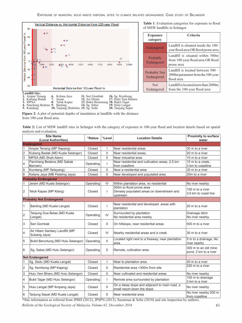
20 landfill sites in Selangor are currently endangered to the risk of flooding (Table 2). The result for inundation analysis (Figure 2) shows that all the endangered sites are also sitting at low elevation hence will be inundated by the modeled flood. The Ampar Tenang landfill which had been closed since 2010 is expected to have the highest risk of damage from a 100-year flooding based on the estimated depth of inundation of 45 m. Ampar Tenang landfill is also exposed to regular floods as it is located inside flood prone area and the same goes to MPSA. Teluk Kapas and Kubang Badak landfills are located very close to the flood prone area and may also be exposed to the risks of regular floods. Many of the landfills in Selangor (both operating and closed) are located near stream and may be exposed to flood and erosion during high stream flow. Three sites are identified to be located in close proximity to the coastlines and may be endangered by risks from coastal impacts and sea level rise, namely Teluk Kapas, Panchang Bedena and Tanjung Sepat.
The potential impacts and cascading hazards based upon the details of location found that all of the sites that are endangered by 100-year flood are also located in close proximity to either populated or cultivated areas. The populations living in the residential areas near the endangered landfills become vulnerable to the cascading hazards from landfill flooding. The cultivated or plantation areas that are located near the endangered landfills such as as Panchang Bedena and Kundang will also be exposed to pollution hazards by these landfills by large flood events.
From the findings of exposure to slope failure analysis, there are two sites that are endangered to the risk of slope,
Figure 1: Distribution of selected landfills and open dumps on topographic, flood prone and 100-year flood zones in the state of Selangor, Malaysia. (Sources: Flood maps: JPBD, 2009; Landfill sites: JPSPN 2013; Suratman & Sefie, 2010; JPBD, 2012).
ExposurE of municipal solid wastE disposal sitEs to climatE rElatEd gEohazards: casE study of sElangor
61Bulletin of the Geological Society of Malaysia, Volume 62, December 2016
Exposure category
Criteria
Endangered Landfill is situated inside the 100-year flood area OR flood prone area
Probably Endangered
Landfill is situated within 500m from 100-year flood area OR flood prone area
Probably Not Endangered
Landfill is located between 500 – 2000m parameter from the 100-year flood area
Not Endangered
Landfill is located more than 2000m from the 100-year flood area
Table 1: Evaluation categories for exposure to flood of MSW landfills in Selangor.
Figure 2: A plot of potential depths of inundation at landfills with the distance from 100-year flood area.
Landfill Site:1. Ampar Tenang 6. Kelana Jaya 11. Seri Gombak 16. Sg. Kembong2. Kubang Badak 7. Jeram 12. Air Hitam 17. Hulu Yam Baharu3. MPSA 8. Teluk Kapas 13. Bukit Beruntung 18. Bukit Tagar4. Panchang Bedena 9. Banting 14. Sg. Sabai 19. Hulu Langat5. Kundang 10. Tanjung Duabelas 15. Sg. Sedu 20. Tanjung Sepat
Table 2: List of MSW landfill sites in Selangor with the category of exposure to 100-year flood and location details based on spatial analysis and evaluation.
Site Name (Local Authorities) *Status *Level Location Details Proximity to surface
water Endangered1 Ampar Tenang (MP Sepang) Closed I Near residential areas 30 m to a river2 Kubang Badak (MD Kuala Selangor) Closed II Near residential areas, 20 m to a river3 MPSA (MD Shah Alam) Closed 0 Near industrial area 10 m to a river
4 Panchang Bedena (MD Sabak Bernam) Operating I Near residential and cultivation areas, 2.5 km
from coastline10 m to a creek,3 km to coastline
5 Kundang (MP Selayang) Closed 0 Near a residential area 30 m to a river6 Kelana Jaya (MB Petaling Jaya) Closed 0 Near developed and populated area 20m to a riverProbably Endangered1 Jeram (MD Kuala Selangor) Operating IV Within plantation area, no residential No river nearby
2 Teluk Kapas (MP Klang) Closed I300m to flood prone areaDensely populated areas on downstream and upstream
100 m to a river3.6 km to coast line
Probably Not Endangered
1 Banting (MD Kuala Langat) Closed I Near residential and developed areas with plantation 20 m to a river
2 Tanjung Dua Belas (MD Kuala Langat) Operating IV Surrounded by plantation
No residential area nearbyDrainage ditchNo river nearby.
3 Seri Gombak Closed 0 On hillslope, near residential areas 500 m to a river
4 Air Hitam Sanitary Landfill (MP Subang Jaya) Closed IV Nearby residential areas and a creek 30 m to a river
5 Bukit Beruntung (MD Hulu Selangor) Operating 0 Located right next to a freeway, near plantation area
5 m to a drainage, No river nearby
6 Sg. Sabai (MD Hulu Selangor) Operating 0 Remote, cultivation area 300 m to an old mine pond, 2 km to a river
Not Endangered1 Sg. Sedu (MD Kuala Langat) Closed I Near to plantation area 20 m to a river
2 Sg. Kembong (MP Kajang) Closed 0 Residential area <300m from site 220 m to a river
3 Hulu Yam Bharu (MD Hulu Selangor) Closed 0 Near cultivated and residential areas No river nearby
4 Bukit Tagar (MD Hulu Selangor) Operating I Remote area surrounded by plantation 100 m to drainage3 km to a river
5 Hulu Langat (MP Ampang Jaya) Closed 0 On a steep slope and adjacent to main road, a small resort down the slope No river nearby
6 Tanjung Sepat (MD Kuala Langat) Closed 0 Near residential area No river nearby 200 m from coastline
*Site information as referred from JPBD (2012), JPSPN (2013), Suratman & Sefie (2010) and site inspection by authors.
Nurul SyazwaNi yahaya, ChouN-SiaN lim, mohd raihaN Taha & Joy JaCqueliNe Pereira
Bulletin of the Geological Society of Malaysia, Volume 62, December 201662
namely Seri Gombak and Hulu Langat. Both sites are located on hilly terrains with 83 m and 132 m topographic height respectively. Even though the height of the Seri Gombak illegal dump is less than 100 m, it is located on such a steep slope and a case of slope failure at the site had also been reported in recent years. The two sites are listed as closed sites by official records but are still actively receiving inert wastes during the time of visit to the sites. Both Hulu Langat and Seri Gombak landfill sites are located close to residential areas down from both sites, endangering the nearby communities. However, more detailed study is required in all waste disposal sites as landslides may even occur in low areas where the height and gradient of slopes make it susceptible to mass movements.
Severe cascading hazards can especially be expected from non-engineered landfills with level 0 and I that are exposed to the risk of flooding and are located within close proximity to developed and populated areas. Detailed study on potential impacts and cascading hazards at each of the endangered sites can be made by considering details of the landfill settings such as volume and age, geomorphology and subsurface geology profile, flow capacity of nearby river and its erosion potentials. For coastal landfills, a detailed future study on the potential coastal hazards to these landfills can be made by including factors such as local sea level profile and field data of the coastal erosion. Meaningful information in looking into the cascading effects includes potential landfill emissions and the extent of waste pollutants migration on the surface and in the subsurface during floods.
CONCLUSIONMalaysia and other developing nations in general
are still struggling towards achieving a sustainable waste management due to increasing waste generation and land scarcity. Along with the rapid development in urbanizing areas, the expansion of settlements closer to landfills will further increase the exposure of the population to the hazards during disaster events, making them vulnerable. Preliminary assessment conducted on landfills and open dumps in Selangor reveals that six out of 20 landfill sites in the state are highly exposed to the100-year flood while two sites are exposed to slope failure (including mass waste movement). The exposed sites are currently without any protection measures making populated areas in the vicinity vulnerable to hazards and their cascading impacts. More detailed investigation is required at the exposed sites to plan appropriate mitigation measures. This is crucial to reduce the risk of disasters and ensure the sustainability of the surrounding population and environment in a changing climate.
ACKNOWLEDGEMENTThe research is funded by grants from ERGS/1/2012/
STWN06/UKM/01/2, XX-2015-004 and DPP-2015-097 led by Prof. Joy Jacqueline Pereira. The authors acknowledge the support of various agencies for sharing of data.
REFERENCESAgamuthu, P., 2001. Solid waste: principles and management: with
Malaysian case studies. University of Malaya Press. 395 p.Agamuthu, P. & Fauziah, S. H., 2011. Challenges and issues in
moving towards sustainable landfilling in a transitory country - Malaysia. Waste Management & Research : the Journal of the International Solid Wastes and Public Cleansing Association, ISWA, 29(1), 13-9.
Albering, H.J., van Leusen, S.M., Moonen, E.J., Hoogewerff, J.A. & Kleinjans, J.C., 1999. Human health risk assessment: a case study involving heavy metal soil contamination after the flooding of the River Meuse during the winter of 1993-1994. Environ. Health Perspect., 107, 37-43.
American Society of Civil Engineers (ASCE), 1959. Sanitary Landfill Manual of Practice, ASCE, New York, USA. 61 p.
Bahaa-eldin, E., A. Rahim, I. Yusoff, A.R. Samsudin, W. Z. W. Yaacob & A. G. M. Rafek. 2010. Deterioration of groundwater quality in the vicinity of an active open-tipping site in West Malaysia. Hydrogeology Journal, 18, 997-1006.
Baker, V.R., Kochel, R.C. & Patton, P.C., 1988. Flood geomorphology. New York: Wiley. 503 p.
Belevi, H. & Baccini, P., 1989. Long-term behavior of municipal solid waste landfills. Waste Management & Research, 7, 43-56.
Bijlsma, L., Ehler, C.N., Klein, R.J.T., Kulshrestha, S.M., McLean, R.F., Mimura, N., Nicholls, R.J., Nurse, L.A., Perez Nieto, H., Stakhiv, E.Z., Turner, R.K. & Warrick, R.A., 1996. Coastal zones and small islands. In: Watson, R.T., Zinyowera, M.C., Moss, R.H. (eds.), Impacts, Adaptations and Mitigation of Climate Change: Scientific Technical Analyses. Cambridge University Press, Cambridge, 289–324.
Blight, GE., 2008. Slope failures in municipal solid waste dumps and landfills: a review. Waste Management and Research, 26, 448-46.
Christensen, J.H., K. Krishna Kumar, E. Aldrian, S.-I. An, I.F.A. Cavalcanti, M. de Castro, W. Dong, P. Goswami, A. Hall, J.K. Kanyanga, A. Kitoh, J. Kossin, N.-C. Lau, J. Renwick, D.B. Stephenson, S.-P. Xie & T. Zhou, 2013. Climate Phenomena and their Relevance for Future Regional Climate Change. In: Stocker, T.F., D. Qin, G.-K. Plattner, M. Tignor, S.K. Allen, J. Boschung, A. Nauels, Y. Xia, V. Bex & P.M. Midgley (eds.), Climate Change 2013: The Physical Science Basis. Contribution of Working Group I to the Fifth Assessment Report of the Intergovernmental Panel on Climate Change. Cambridge University Press, Cambridge, United Kingdom and New York, NY, USA. 1217-1308
Crozier, M.J., 2010. Deciphering the effect of climate change on landslide activity: A review. Geomorphology, 124, 260-267.
Curtis J.A. & Whitney J.W., 2003. Geomorphic and Hydrologic Assessment of Erosion Hazards at the Norman Municipal Landfill, Canadian River Floodplain, Central Oklahoma. Environ. & Engineering Geoscience, 9, 241-53.
Department of Local Government, 2006. The Technical Guideline for Sanitary Landfill: Design and Operation. Ministry of Housing and Local Government Malaysia.
EM-DAT, 2014. The OFDA/CRED International Disaster Database, www.emdat.be - Université catholique de Louvain - Brussels – Belgium. Accessed 20 March 2014.
El-Fadel, Mutasem, Angelos N. Findikakis & James O. Leckie, 1997. Environmental Impacts of Solid Waste Landfilling. Journal of Environmental Management, 50(1), 1-25.
Flynn, T.J., Walesh, S.G., Barth, M.C. & Titus J.G., 1984. Implications of Sea Level Rise for Hazardous Waste Sites in Coastal Floodplains. In: Greenhouse Effect and Sea Level

ExposurE of municipal solid wastE disposal sitEs to climatE rElatEd gEohazards: casE study of sElangor
63Bulletin of the Geological Society of Malaysia, Volume 62, December 2016
Rise: A Challenge for this Generation. Van Nostrand Reinhold Company Inc., 271-294.
Gasim, M. B., Surif, S, Mokhtar, M., Hj Toriman, M. E., Abd. Rahim, S. & Bee, C. H., 2010. Analisis Banjir Disember 2006: Tumpuan di Kawasan Bandar Segamat, Johor (Flood Analysis of December 2006: Focus at Segamat Town, Johor). Sains Malaysiana, 39(3), 353-361.
Giusti, L., 2009. A review of waste management practices and their impact on human health. Waste Management (New York), 29, 2227-39.
Hwang, J-S, 2002. Effect and Hazard Analysis of Natural Disaster to Waste Landfill. Journal of the Chinese Institute of Environmental Engineering, 12(2), 167-174.
Jabatan Perancangan Bandar dan Desa Semenanjung Malaysia (JPBD), 2010. Kementerian Perumahan dan Kerajaan Tempatan. Rancangan Fizikal Negara Ke-2. 306 p.
Jabatan Perancangan Bandar dan Desa Semenanjung Malaysia (JPBD), 2012. Laporan Tinjauan Kajian Rancangan Struktur Negeri Selangor 2035. Bidang B Perancangan Spatial. B.13: Sisa Pepejal.
Jabatan Pengairan dan Saliran Malaysia (JPS), 2013: Fenomena Banjir Malaysia. http://www.water.gov.my/images/pdf/fenomenabanjir_msia.pdf. Accessed on 10 November, 2013.
Jabatan Pengurusan Sisa Pepejal Negara (JPSPN), 2013. Negeri Selangor. Bilangan Tapak Pelupusan Mengikut Negeri (Beroperasi & Tidak Beroperasi. http://www.kpkt.gov.my/jpspn_2013/main.php?Content=articles&ArticleID=55 IID. Accessed 27 February, 2014.
Klink R.E. & Ham R.K., 1982. Effects of moisture movement on methane production in solid waste landfill samples. Resource Conservation, 8, 29-41.
Laner, D., Fellner, J. & Brunner, P. H., 2009. Flooding of municipal solid waste landfills- An environmental hazard? Science of the Total Environment, 407, 3674-3680.
Laner, D., Fellner, J., Brunner, P. H., Neuhold, C. & Kolesar, Ch., 2008. Environmental Relevance of flood MSW Landfills in Austria. In: Proceedings ISWA/WMRAS World Congress 2008 ‘East meets Waste’. Hrsg. ISWA, 3-6. November, Singapore, 1-10.
Leete, R., 2005. Selangor’s Human Development: Progress and Challenges. United Nations Development Programme (UNDP) http://dspace.cigilibrary.org/jspui/handle/123456789/20421. Accessed 29 April 2014.
May, F., 2007. In: Butler, Bret W.; Cook, Wayne, comps The fire environment- innovations, management, and policy; conference proceedings. 26-30 March 2007; Destin, FL. Proceedings RMRS-P-46CD. Fort Collins, CO: U.S. Department of Agriculture, Forest Service, Rocky Mountain Research Station. 662 p. CD-ROM.
Meehl, G.A., T.F. Stocker, W.D. Collins, P. Friedlingstein, A.T. Gaye, J.M. Gregory, A. Kitoh, R. Knutti, J.M. Murphy, A. Noda, S.C.B. Raper, I.G. Watterson, A.J. Weaver & Z.-C. Zhao, 2007. Global Climate Projections. In: Solomon, S., D. Qin, M. Manning, Z. Chen, M. Marquis, K.B. Averyt, M. Tignor & H.L. Miller (eds.) Climate Change 2007: The Physical Science Basis. Contribution of Working Group I to the Fourth Assessment Report of the Intergovernmental Panel on Climate Change. Cambridge University Press, Cambridge, United
Manuscript received 22 May 2014Revised manuscript received 10 August 2015
Manuscript accepted 6 September 2015
Kingdom and New York, NY, USA, 747-845.Mohd, A. S. N., Yusoff, S. & Piaw, C. Y., 2013. Soil chemistry
and pollution study of a closed landfill site at Ampar Tenang, Selangor, Malaysia. Waste Management & Research : the Journal of the International Solid Wastes and Public Cleansing Association, Iswa, 31(6), 599-612.
Nicholls, R.J., 2002. Analysis of global impacts of sea-level rise: a case study of flooding. Physics and Chemistry of the Earth, 27, 1455–1466.
Norafiza Jaafar, 2013. Tapak lupus sampah runtuh. Sinar Harian, 1 Oct 2013. Accessed 15 October 2013.
Pescaroli, G. & Alexander, D., 2014. A definition of cascading disasters and cascading effects: Going beyond the "toppling dominos" metaphor. GRF Davos Planet@Risk, Special Issue on the 5th IDRC Davos 2014, March 2015, Vol. 3(1), 58-67.
Randy V. Datu, 2013. Dumpsite blamed for Olongapo leptospirosis outbreak, 14 Oct 2013. Accessed 23 Oct 2013. http://www.rappler.com/nation/41344-dumpsite-olongapo-leptospirosis outbreak.
Rudis, M., Valenta, Petr., Valentova, J. & Nol, O., 2009. Assessment of the deposition of polluted sediments transferred by a catastrophic flood and related changes in groundwater quality. Journal of Hydrology, 369, 326-335.
Seneviratne, S.I., N. Nicholls, D. Easterling, C.M. Goodes, S. Kanae, Y. Luo, J. Marengo, K. Mclnnes, M. Rahimi, M. Reichstein, A. Sorteberg, C. Vera & Zhang, 2012. Changes in climate extremes and their impacts in the natural physical environment. In: Field, C.B., V. Barros, T.F. Stocker, D. Qin, D.J. Dokken, K.L. Elbi, M.D. Mastrandrea, K.J. Mach, G.-K. Plattner, S.K. Allen, M. Tignor & P.M. Midgley (eds.). Managing the Risks of Extreme Events and Disasters to Advance Climate Change Adaptation. A Special Report of Working Groups I and II of the intergovernmental Panel on Climate Change (IPCC). Cambridge University Press, Cambridge, UK, and New York, NY, USA, 109-230.
Sharifah N. S. Ismail & Latifah Abd. Manaf, 2013. The challenge of future landfill: A case study of Malaysia. Journal of Toxicology and Environmental Health Sciences, 5(6), 86-96.
Suratman, S. & Sefie. A., 2010. Groundwater contamination at landfill sites in Selangor. IAH, Krakow. 2205-11.
Suryani Dalip, 2001. Alam Flora refutes it’s to be blamed for floods. Siraj: Problem at Kundang landfill nothing to do with us. News Strait Times. 8 May. City, page 1.
Taha, M. R., Yaacob, W. Z. W., Samsudin, A. R. & Yaakob, J., 2011. Groundwater quality at two landfill sites in Selangor, Malaysia. Bulletin of the Geological Society of Malaysia, 57, 13-18.
Van Eeten, M., Nieuwenhuijs, A., Luiijf, E., Klaver, M. & Cruz, E., 2011. The State and the Threat of Cascading Failure across Critical Infrastructures: The Implications of Empirical Evidence from Media Incident Reports, Public Administration, 89 (2), 381–400.
Yong, R. N., Mulligan, C. N. & Fukue, M., 2007. Geoenvironmental Sustainability. Boca Raton, FL: CRC Taylor & Francis. 387 p.
Young S., Balluz, L. & Malilay, J., 2004. Natural and technologic hazardous material releases during and after natural disasters: a review. Sci. Total Environ., 3223, 3-20.