unosat-maps.web.cern.chunosat-maps.web.cern.ch/unosat-maps/id/...indonesia_floods_garut.pdf · this...

1
" ) " ) Godog Haurpanggung Sindanggalih Kersamenak Ngamplangsari Situgede Sadang Karyamukti Sukasenang Jatisari Lebakagung Pamekarsari Karangmulya Situsari Lebakjaya Mekarsari Dangdeur Cinunuk Sucikaler Sukakarya Sukamantri Karangpawitan Paminggir Wanamekar Sirnajaya Sukaraja Sukamulya Sukajaya Situsaeur Tanjungsari Jayawaras Sukamukti Salakuray Sukaratu Cimurah Pakuwon Cibunar Jayaraga Wanaraja Karangsari Muara Sanding Linggamukti Mekargalih Sukarasa Maripari Tanjungkamuning Sukalaksana Rancabango Cintarasa Sindangratu Regol Mekarjaya Lengkongjaya Suci Kotawetan Binakarya Situjaya Sukabakti Margahayu Ciwalen Sukagalih Sindanglaya Karyasari Kotakulon Cipicung Sindangpalay Tegalpanjang Garut Tarogong 107°59'0"E 107°59'0"E 107°58'0"E 107°58'0"E 107°57'0"E 107°57'0"E 107°56'0"E 107°56'0"E 107°55'0"E 107°55'0"E 107°54'0"E 107°54'0"E 107°53'0"E 107°53'0"E 107°52'0"E 107°52'0"E 107°51'0"E 107°51'0"E 7°9'0"S 7°9'0"S 7°10'0"S 7°10'0"S 7°11'0"S 7°11'0"S 7°12'0"S 7°12'0"S 7°13'0"S 7°13'0"S 7°14'0"S 7°14'0"S ! I Satellite Data (1): TerraSAR-X Imagery Dates: 22 April 2012 Resolution: 3 m Copyright: DLR e. V. 2016, Distribution Airbus DS Geo GmbH Source: DLR Satellite Data (2): TerraSAR-X Imagery Date: 25 September 2016 Resolution: 3 m Copyright: DLR e. V. 2016, Distribution Airbus DS Geo GmbH Source: DLR Pre Flood Data: BIG (Indonesian Geospatial Information Agency) Road Data : OpenStreetMap (via bbbike.com) Other Data: USGS, UNCS, NASA, NGA Analysis : UNITAR - UNOSAT Production: UNITAR - UNOSAT Analysis conducted with ArcGIS v10.3 Coordinate System: WGS 1984 UTM zone 48S Projection: Transverse Mercator Datum: WGS 1984 Units: Meter The depiction and use of boundaries, geographic names and related data shown here are not warranted to be error-free nor do they imply official endorsement or acceptance by the United Nations. UNOSAT is a program of the United Nations Institute for Training and Research (UNITAR), providing satellite imagery and related geographic information, research and analysis to UN humanitarian and development agencies and their implementing partners. This work by UNITAR/UNOSAT is licensed under a Creative Commons Attribution-NonCommercial- This map illustrates satellite-detected areas of wet & saturated soils in Garut Regency, Jawa Barat Province, Indonesia, extracted from TerraSAR-X images (3 m) acquired on 22 April 2012 (pre-event) and on 25 September 2016 (post-event). Waters along the Kali Cimanuk remain in the riverbed without causing floods. Possible wet/ saturated soils are visible as of 25 September 2016 over mainly agricultural areas. As of 25 September 2016, ~ 450 ha of lands were potentially affected, mainly in Karangpawitan & Banyuresmi districts. The exact limit of flood waters is uncertain because of the low spatial resolution of the satellite data used for this analysis. Detected water bodies likely reflect an underestimation of all flood- affected areas within the map extent. This is a preliminary analysis and has not yet been validated in the field. Please send ground feedback to UNITAR-UNOSAT. ! ! , Flooding Disaster coverage by the International Charter 'Space and Major Disasters'. For more information on the Charter, which is about assisting the disaster relief organizations with multi-satellite data and information, visit www.disasterscharter.org ¥ ¦ ¬ ¥ ¦ ¬ ¥ ¦ ¬ ¥ ¦ ¬ ¥ ¦ ¬ Production Date: 28/09/2016 Version 1.0 Activation Number: FL20160924IDN Analysis with TerraSAR-X Data Acquired 25 September 2016 & 22 April 2012 0 0.4 0.8 1.2 1.6 2 0.2 Km LEGEND Map Extent F Map Scale for A3: 1:50,000 SATELLITE IMAGE DERIVED ANALYSIS Pre-Crisis Water Extent BIG (Indonesian Geospatial Information Agency) Possible Water Extent & Saturated Soils TerraSAR-X - 25 September 2016 (Satellite-Based Classification) Contact Information: [email protected] 24/7 Hotline: +41 75 411 4998 www.unitar.org/unosat City " ) Town Village Primary Road Secondary Road District Boundary Jakarta Singapore Dili Kuala Lumpur

Upload: doanhanh

Post on 02-Mar-2019

258 views

Category:

Documents


0 download

TRANSCRIPT

")

")

Godog

Haurpanggung

SindanggalihKersamenak

Ngamplangsari

Situgede

Sadang

Karyamukti

Sukasenang

Jatisari

Lebakagung

Pamekarsari

Karangmulya

Situsari

Lebakjaya

Mekarsari

Dangdeur

Cinunuk

Sucikaler

Sukakarya

SukamantriKarangpawitan

Paminggir

Wanamekar

Sirnajaya

SukarajaSukamulya

Sukajaya

Situsaeur

Tanjungsari

Jayawaras

Sukamukti

Salakuray

Sukaratu

Cimurah

Pakuwon

Cibunar

Jayaraga

Wanaraja

Karangsari

MuaraSanding

Linggamukti

Mekargalih

Sukarasa

Maripari

Tanjungkamuning

Sukalaksana

Rancabango

Cintarasa

Sindangratu

Regol

Mekarjaya

Lengkongjaya

Suci

Kotawetan

Binakarya

Situjaya

Sukabakti

Margahayu

Ciwalen

Sukagalih

Sindanglaya

Karyasari

Kotakulon

Cipicung

Sindangpalay

Tegalpanjang

Garut

Tarogong

107°59'0"E

107°59'0"E

107°58'0"E

107°58'0"E

107°57'0"E

107°57'0"E

107°56'0"E

107°56'0"E

107°55'0"E

107°55'0"E

107°54'0"E

107°54'0"E

107°53'0"E

107°53'0"E

107°52'0"E

107°52'0"E

107°51'0"E

107°51'0"E

7°9'0

"S

7°9'0

"S

7°10

'0"S

7°10

'0"S

7°11

'0"S

7°11

'0"S

7°12

'0"S

7°12

'0"S

7°13

'0"S

7°13

'0"S

7°14

'0"S

7°14

'0"S

!ISatellite Data (1): TerraSAR-XImagery Dates: 22 April 2012Resolution: 3 mCopyright: DLR e. V. 2016, Distribution Airbus DS GeoGmbHSource: DLRSatellite Data (2): TerraSAR-XImagery Date: 25 September 2016Resolution: 3 mCopyright: DLR e. V. 2016, Distribution Airbus DS GeoGmbHSource: DLRPre Flood Data: BIG (Indonesian Geospatial InformationAgency)Road Data : OpenStreetMap (via bbbike.com)Other Data: USGS, UNCS, NASA, NGAAnalysis : UNITAR - UNOSATProduction: UNITAR - UNOSATAnalysis conducted with ArcGIS v10.3Coordinate System: WGS 1984 UTM zone 48SProjection: Transverse MercatorDatum: WGS 1984Units: MeterThe depiction and use of boundaries, geographic namesand related data shown here are not warranted to beerror-free nor do they imply official endorsement oracceptance by the United Nations. UNOSAT is aprogram of the United Nations Institute for Training andResearch (UNITAR), providing satellite imagery andrelated geographic information, research and analysis toUN humanitarian and development agencies and theirimplementing partners.This work by UNITAR/UNOSAT is licensed under aCreative Commons Attribution-NonCommercial-

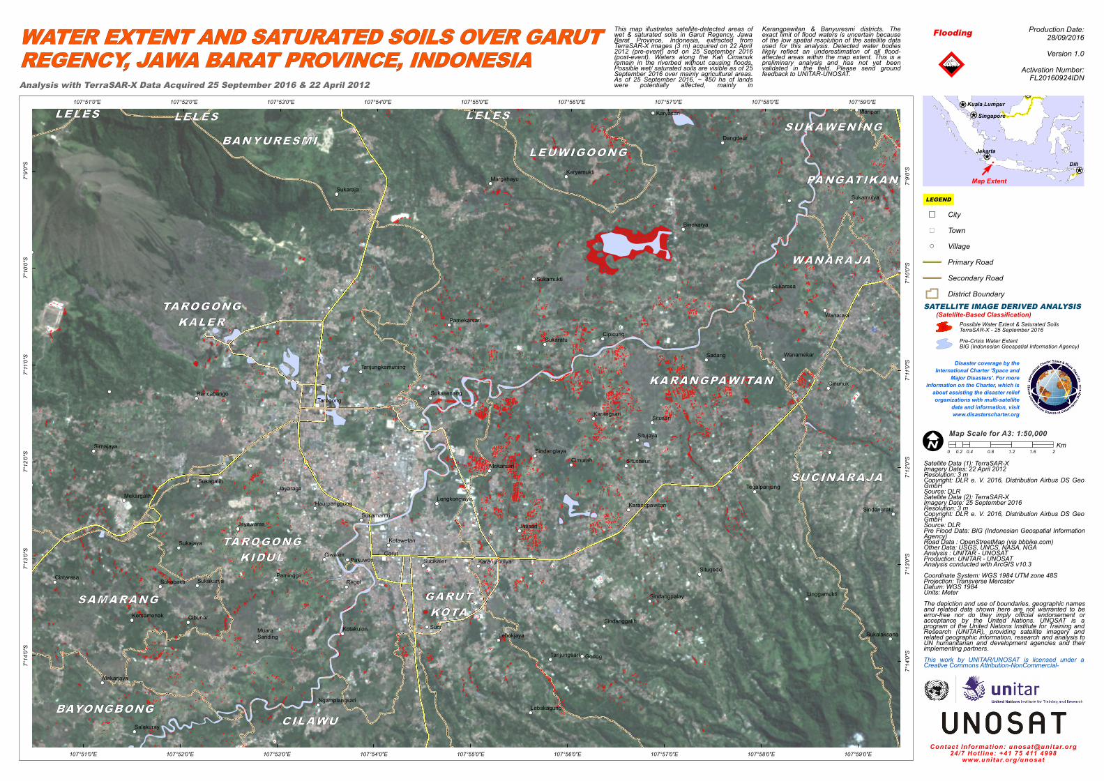
This map illustrates satellite-detected areas ofwet & saturated soils in Garut Regency, JawaBarat Province, Indonesia, extracted fromTerraSAR-X images (3 m) acquired on 22 April2012 (pre-event) and on 25 September 2016(post-event). Waters along the Kali Cimanukremain in the riverbed without causing floods.Possible wet/ saturated soils are visible as of 25September 2016 over mainly agricultural areas.As of 25 September 2016, ~ 450 ha of landswere potentially affected, mainly in

Karangpawitan & Banyuresmi districts. Theexact limit of flood waters is uncertain becauseof the low spatial resolution of the satellite dataused for this analysis. Detected water bodieslikely reflect an underestimation of all flood-affected areas within the map extent. This is apreliminary analysis and has not yet beenvalidated in the field. Please send groundfeedback to UNITAR-UNOSAT. !!,

Flooding

Disaster coverage by theInternational Charter 'Space and

Major Disasters'. For moreinformation on the Charter, which is

about assisting the disaster relieforganizations with multi-satellite

data and information, visitwww.disasterscharter.org

¥¦¬

¥¦¬

¥¦¬

¥¦¬¥¦¬

Production Date:28/09/2016Version 1.0

Activation Number:FL20160924IDNAnalysis with TerraSAR-X Data Acquired 25 September 2016 & 22 April 2012

0 0.4 0.8 1.2 1.6 20.2Km

LEGENDMap ExtentF

Map Scale for A3: 1:50,000

SATELLITE IMAGE DERIVED ANALYSIS

Pre-Crisis Water Extent BIG (Indonesian Geospatial Information Agency)

Possible Water Extent & Saturated SoilsTerraSAR-X - 25 September 2016

(Satellite-Based Classification)

Contact Information: [email protected]/7 Hotline: +41 75 411 4998

www.unitar.org/unosat

City") Town

VillagePrimary RoadSecondary RoadDistrict Boundary

Jakarta

Singapore

Dili

Kuala Lumpur