universiti putra malaysia satellite remote...
TRANSCRIPT
UNIVERSITI PUTRA MALAYSIA
SATELLITE REMOTE SENSING TECHNOLOGY FOR FOREST TYPE CLASSIFICATION AND INVENTORY IN GUNUNG STONG FOREST
RESERVE, KELANTAN, MALAYSIA
ZAILANI KHUZAIMAH
FH 2000 10
SATELLITE REMOTE SENSING TECHNOLOGY FOR FOREST TYPE CLASSIFICATION AND INVENTORY IN GUNUNG STONG FOREST
RESERVE, KELANTAN, MALAYSIA
By
ZAILANI KHUZAIMAH
Thesis Submitted in Fulfilment of the Requirement for the Degree of Master of Science in the Faculty of Forestry
Universiti Putra Malaysia
November 2000
111
Abstract of thesis submitted to the Senate of Universiti Putra Malaysia in fulfilment of the requirement for the degree of Master of Science .
SATELLITE REMOTE SENSING TECHNOLOGY FOR FOREST TYPE CLASSIFICATION AND INVENTORY IN GUNUNG STONG FOREST
RESERVE, KELANTAN, MALAYSIA
By
ZAILANI KHUZAIMAH
November 2000
Chairman : Professor Capt. Kamaruzaman Jusoff, Ph.D.
Faculty : Forestry
In Malaysia and other developing countries access to the forest
area is often difficult and forest information is inadequate. Remote
sensing in forestry is very valuable and it has become important due to
its capability to collect data from large areas and its capability to
generate information. In other words, remote sensing technology offers
reliable information essential for forest management and inventory.
The objective of this study is to develop a technique for preliminary
estimation of timber volume using satellite remote sensing imagery.
Based on data analysis of the Landsat TM imagery, six classes of land
cover were classified such as Primary Forest, Logged-Over Forest,
Degraded Forest/ Plantation, Shrub, Barren Land/ Cloud and Water
Bodies/ Shadow. Using a forest canopy density technique, three volume
intensity categories can be mapped out such as High Density (>35 m3 -
IV
1 00 m3 j ha) , Medium Density (20 m3 - 35 m3 jha) and Low Density (below
20 m3 j ha) with an overall accuracy assessment of about 97 .30 percent.
The results of these studies imply that Malaysian loggers can now utilize
these maps to have a preliminary estimate of the timber volume in the
concession areas without really "flying over" the inaccessible sites.
Consequently from the government's point of view, preliminary estimate
of the concession fees can now be imposed on the loggers.
It can be concluded that satellite remote sensing (i .e. Landsat TM)
can be successfully used in forest type classification and inventory for
macro-forest planning in Malaysia. However, high resolution satellite
remote sensing data such as IKONOS-1 or THEMAP airborne data taken
from aircraft should be further investigated for micro-planning in forest
management due to its high resolution capability for individual tree
counting and mapping.
v
Abstrak tesis yang dikemukakan kepada Senat Universiti Putra Malaysia sebagai memenuhi keperluan untuk mendapatkan ijazah Master Sains.
TEKNOLOGI SATELIT PENDERIAAN JARAK JAUH UNTUK PENGKELASAN HUTAN DAN INENTORI DI HUTAN SIMPAN GUNUNG
STONG, KELANTAN, MALAYSIA
Oleh
ZAILANI KHUZAIMAH
November 2000
Pengerusi :Profesor Kapt. Kamaruzaman Jusoff, Ph.D.
Fakulti :Perhutanan
Di Malaysia dan negara membangun yang lain, untuk masuk ke
dalam kawasan hutan adalah sukar dan kurangnya maklumat mengenai
hutan. Penggunaan penderiaan jarak jauh dalam perhutanan sangat
berkesan dan akan menjadi penting disebabkan oleh keupayaan untuk
mengumpul data dari kawasan yang luas dan berupaya untuk
menghasilkan maklumat. Dengan kata lain teknologi penderiaan jarak
jauh dapat menghasilkan maklumat yang diperlukan dengan lebih tepat
untuk pengurusan dan iventori hutan.
Objektif kajian ini adalah untuk membangunkan teknik awal bagi
mengira isipadu balak dengan menggunakan imaj satelit penderiaan
jarak jauh. Berpandukan kepada analisa data dari imej Landsat TM,
enam kelas litupan tanah dapat dikelaskan dalam kawasan kajian iaitu
vi
Hutan Prima, Hutan Lepas-Tebangan, Hutan MiskinjKawasan
Pertanian, Semak, Tanah Terbukaj Awan dan Jasad Air jBayang. Dengan
menggunakan teknik kepadatan silara hutan, tiga jenis kepadatan
isipadu dapat di petakan iaitu Kepadatan Tinggi (>35 m3 - 1 00 m3 jha) ,
Kepadatan Sederhana (20 m3 - 35 m3 jha) , dan Kepadatan Rendah
(dibawah 20 m3 jha) dengan ketepatan keseluruhan lebih kurang
97.26%. Daripada keputusan kajian ini kini pembalak di Malaysia dapat
menggunakan peta ini untuk membuat anggaran kasar nilai balak
dalam kawasan konsesi tanpa memasuki kekawasan yang sukar untuk
dimasuki. Bagi pihak kerajaan pula, dapat penganggaran jumlah cukai
konsesi boleh di perkenalkan kepada pembalak.
Pada kesimpulanya, satelit penderiaan j arak jauh boleh dengan
jayanya digunakan untuk pengkelasan hutan dan iventori di peringkat
makro dalam perancangan hutan di Malaysia. Walaubagaimanapun
penggunaan data satelit penderiaan jarak jauh yang beresolusi tinggi
seperti data IKONOS- 1 atau THEMAP yang diambil dari pesawat udara
perlu dikaji dalam penyelidikan dimasa hadapan untuk pengurusan
hutan di perigkat mikro kerana data yang beresolusi tinggi
berkeupayaan untuk pengiraan isipadu setiap pokok dan pemetaanya.

Vll
ACKNOWLEDGEMENTS
Bismillahirahmanirahim,
Praise to the Allah Almighty for His blessings, which enables me to
complete this thesis. I would like to express my deepest appreciation to
my Supervisor, Prof. Capt. Dr. Kamaruzaman Jusoff for his invaluable
guidance and constructive criticisms throughout this study.
My gratitude is also expressed to Prof. Dato' Dr. Nik Muhamad
Majid and Assoc. Prof. Dr. Faridah Hanum Ibrahim for their useful
comments.
Special appreciation goes to the staff of the Center for Precision
Agriculture and Bioresource Remote Sensing, Institute of Bioscience for
invaluable comments and ideas on writing this thesis.
Last but not least, special appreciation is also dedicated to my
beloved family and Asmidawati Ashari for her support.
viii
I certify that an Examination Committee met on 21 November 2000 to conduct the final examination of Zailani Khuzaimah on his Master of Science thesis entitled "Satellite Remote Sensing Technology for Forest Type Classification and Inventory in Gunung Stong Forest Reserve, Kelantan" in accordance with Universiti Pertanian Malaysia (Higher Degree) Act 1980 and Universiti Pertanian Malaysia (Higher Degree) Regulation 1 981. The committee recommends that the candidate be awarded the relevant degree. Members of the Examination Committee are as follows:
ISMAIL ADNAN ABD. MALEK, M.Sc. Lecturer Faculty of Forestry Universiti Putra Malaysia (Chairman)
KAMARUZAMAN JUSOFF, Ph.D. Professor Faculty of Forestry Universiti Putra Malaysia (Members)
DATO' NIK MUHAMAD AB. MAJID, Ph.D Professor Faculty of Forestry Universiti Putra Malaysia (Member)
FARIDAH HANUM IBRAHIM, Ph.D Associate Professor/ Head Department of Forest Production Faculty of Forestry Universiti Putra Malaysia (Member)
HAZALI MOHAYIDIN, Ph.D. Professor / Depu ty Dean of Graduate School Universiti Putra Malaysia
Date :
o 5 DEC 2000
ix
This thesis submitted to Senate of Universiti Putra Malaysia has been accepted as fulfilment of the requirement for the degree of Master of Science.
,7
KAMIS AWANG, Ph.D. Associate Professor Dean of Graduate School Universiti Putra Malaysia
Date : 1 1 .IAN 2001
x
DECLARATION
I hereby declare that the thesis is based on my original work except for quotations and citations, which have been duly acknowledged. I also declare that it has not been previously or concurrently submitted for any other degree at UPM or other institutions.
Date : 5 December 2000
TABLE OF CONTENT
DEDICATION ABSTRACT ABSTRAK ACKNO�EDGEMENTS APPROVAL SHEETS DECLARATION FORM LIST OF TABLE LIST OF FIGURE LIST OF ABBREVIATION
CHAPTER
I
II
III
INTRODUCTION General J u stifica tion Objective
LITERATURE REVIEW Status of Forest Inventory in Malaysia Definition of Satellite Remote Sensing Landsat MSS and TM System
Multispectral Scanner (MSS) Thematic Mapper (TM)
Thematic Mapping Bands and Combination Application of Remote Sensing in Forest Type Classification and Inventory
MATERIALS AND METHODS Description of Study Area Topography and Climate Materials Data Acquisition Image Processing System Global Positioning System (GPS) Methods Digital Image Analysis Pre-Processing Image Enhancement Technique Contrast Enhancement Spatial Filtering Thematic Mapping Bands and Combination Development of Forest Canopy Density (FCD)
Page 11
iii v
vii viii x
xiii xiv xv
1 1 4 7
8 8
13 19 19 21 23
29
50 50 52 53 53 54 55 56 58 58 60 63 64
65
67
XI
XlI
Image Classification 70 U nsu pervised Classification 72 Su pervised Classification 76 Ground Truth 79 Accuracy Assessment 82
IV RESULTS AND DISCUSSIONS 84 Band Combination and Image Enhancement 84 Forest Canopy Density 86 Image Classification 93
U nsu pervised Classification 93 Supervised Classification 96
Ground Truthing 1 00 Timber Volume Estimation 102 Accuracy Assessment 1 05
V CONCLUSIONS AND RECOMMENDATIONS 1 07 Conclusions 107 Recommendations 1 08 REFERENCE 109 APPENDICES 117 BIODATA OF AUTHORS 1 39
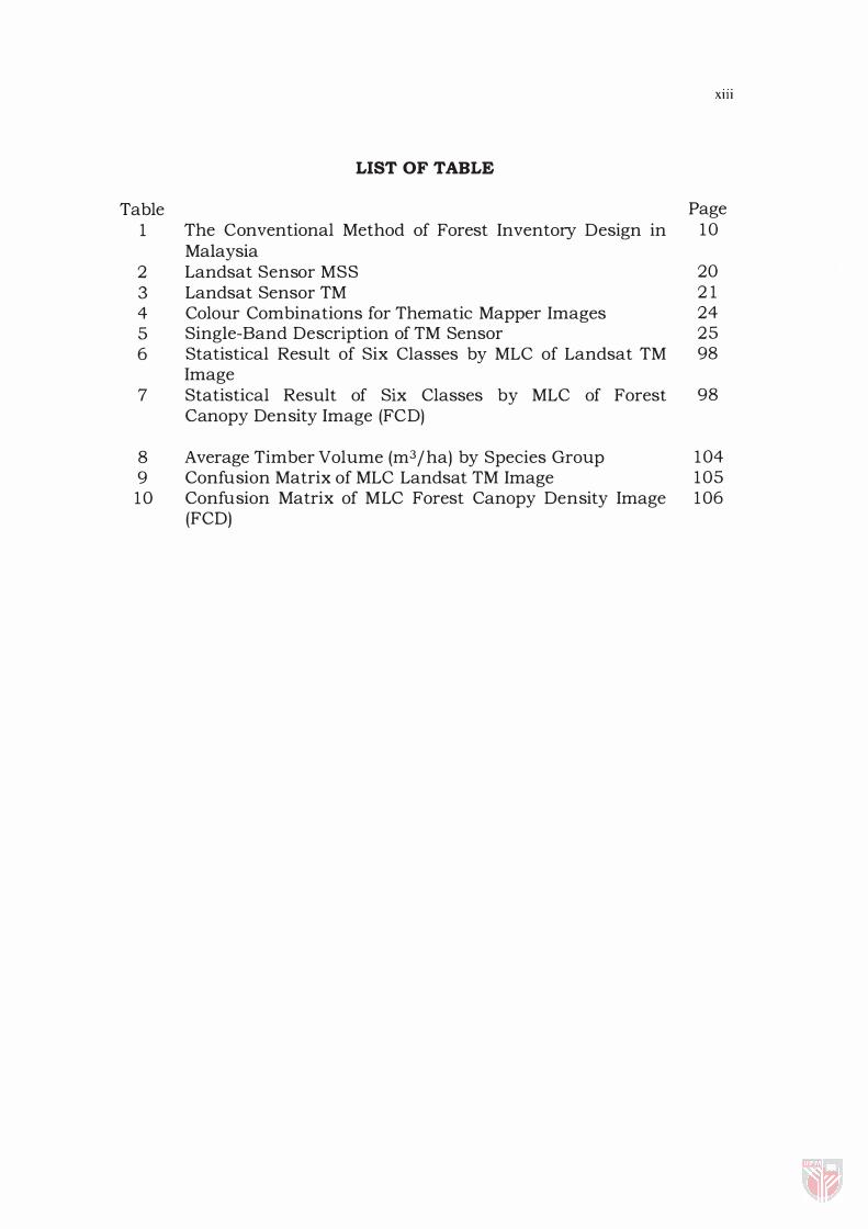
Table 1
2 3 4 5 6
7
8 9
10
LIST OF TABLE
The Conventional Method of Forest Inventory Design in Malaysia Landsat Sensor MSS Landsat Sensor TM Colour Combinations for Thematic Mapper Images Single-Band Description of TM Sensor Statistical Result of Six Classes by MLC of Landsat TM Image Statistical Result of Six Classes by MLC of Forest Canopy Density Image (FCD)
Average Timber Volume (m3 jha) by Species Group Confusion Matrix of MLC Landsat TM Image Confusion Matrix of MLC Forest Canopy Density Image (FCD)
X11I
Page 10
20 21 24 25 98
98
104 105 106
Figure 1 2 3
4a 4b 4c 4d 4e 4f 4g 5 6 7
8a 8b 8c 8d 9
10
11 1 2 13
1 4 15 1 6 17 18
19
20
21
22
LIST OF FIGURES
Diagram of Landsat Image Map Processing Data Collection by Remote Sensing Spectral Signature of Various Natural Surface Features Band 1 Landsat TM Band 2 Landsat TM Band 3 Landsat TM Band 4 Landsat TM Band 5 Landsat TM Band 6 Landsat TM Band 7 Landsat TM A Map of Kelantan Showing the Study Area Trimble GeoExplorer II
Flowchart of the Study Average Filter Laplacian Filter Median Filter Edge Sharpening Filter Relation between Forest Condition and Each Index Flowchart of FeD Development Sampling Plot Design for Ground Truthing The Location of Training Sites False Color Composite of Band 453 of Landsat TM Image Advance Vegetation Index (A VI) of the Study Area Bare Soil Index (BI) of the Study Area Shadow Index (SI) of the Study Area Forest Canopy Density Image of the Study Area Five Classes of Unsupervised Classification of Landsat TM Image of the Study Area Three Classes of Unsupervised Classification of Forest Canopy Density Image of the Study Area Six Classes of Land Cover Type of MLC on Landsat TM Image Four Classes of Supervised Classification of Forest Canopy Density Image of Gunung Stong Forest Reserve Timber Volume Estimation of Gunung Stong Forest Image
XIV
Page 15 17 18 25 26 26 27 27 28 28 51 55 57 66 66 66 66 69
80 80
85 87 89 90 92
94
95
97
99 103

AVI
BI
CCT
FCC
FCD
F.R.
GCP
GIS
GPS
ITTO
MAC RES
MLC
MSS
PC
SI
SPOT
TM
LIST OF ABBREVIATION
Advance Vegetation Index
Bare Soil Index
Computer Compatible Tape
False Colour Composite
Forest Canopy Density
Forest Reserve
Ground Control Point
Geographic Information System
Global Positioning System
International Timber Trade Organization
Malaysia Center for Remote Sensing
Maximum Likelihood Classification
Multispectral Scanner
Principal Component
Shadow Index
xv
Satellite Probatoire d 'Observation de la Terre
Thematic Mapper
CHAPTER I
INTRODUCTION
General
Forest plays a major role in supporting the life of mankind. For
example, supplying timber, storing water, preventing landslides or
debris flows, providing protection from strong winds and purifying the
atmosphere. Recently, people have come to appreciate forests not only
as a source a timber, but also as a place where contact with nature can
be enjoyed.
Malaysian tropical rainforest IS one of the most complex
ecosystems in the world. Its unique natural heritage, which has evolved
millions of years, and is rich and varied in plant and animal life . The
remarkably rich flora of Malaysia is estimated to include at least 8 ,000
species of flowering plants, of which 2 ,500 are tree species. Therefore,
there are many different rain forest formations, depending on factors
such as edaphic conditions, drainage, and altitude. At an elevation of
about 750m, there are species rich lowland and hill dipterocarp
dominated forests in dryland areas and in the wetland areas mangrove,
peat-swamp thrive . The upper montane rainforest formations grows
2
between 750m and 1 , 500m, respectively. The upper dipterocarps are
replaced by oak and laurel dominated forest above about 1 2 ,000m.
The total land area of Peninsular Malaysia is approximately 1 3 . 2
mill. ha, of which 5 . 9 7 mil. h a or 45.3% i s forested. This area comprises
5 .67 mill. ha of Diptrocarp forest, 0 .2 mil. ha mangrove forest (Anon,
1992) . Of the forested area, 5 .25 mil. ha have been designated
Permanent Forest estate (PFE) and the balance in State land Forest.
Although forest stand growth models have become increasingly
important for updates inventory information and projecting future forest
conditions, such updating are limited because of cropland abandonment,
harvesting, and urban development. Such changes are extremely difficult
to models and that is the major reason why satellite remote sensing data
need to be fully utilized. Since the mean characteristics of forest strata
change relatively little, the major inventory problem is to estimate the
amount and location of such strata.
Conventional ground surveys, even though more reliable and
accurate in forest inventory and mapping are not cost and time effective.
This method cannot be used for updating the desire information at any
short period of time. The study of growth and depletion of forest
resources and damage areas, which require constant monitoring, is very
slow with these methods. This is why it becomes imperative to resort to
3
the use of advanced and sophisticated technique of remote sensing for
data collection and monitoring the changes (Tomar 1976 ) .
New methods of mapping vegetation must b e considered to meet
the demand for timely and accurate information about ecosystems. This
method must consider the entire landscape, including adjacent land
under separate ownership, land designated as wilderness, and other land
often excluded from inventories and analyses. Remote sensing and GIS
are providing new tools for advancing ecosystem management. Satellite
imagery is only one of the many remote sensing tools available to
resources managers, yet it offers the most comprehensive perspectives of
all. It allows users to view and manipulate large areas of land, such as an
entire forest or region.
Remote sensing is a particularly useful tool for forestry
applications. The spectral resolution of the sensors, and the repetitive
coverage and digital nature of data allow detecting forest conditions
which cannot be recognized by the human eye. Different techniques exist
for differentiating and mapping forest units. For studying large area, data
can be processed in an automated way; for thematic mapping, images
are visually interpreted, enabling the forestry experts to use their
knowledge and experience.
4
Justification
The area of tropical forest decreases and the ecosystem become
poorer at an alarming rate due to shifting cultivation, uncontrolled
logging and unplanned land uses. The most serious problems occur in
the zones of tropical rain forest. Data collection is difficult and ground
measurements are expensive due to poor infrastructure (Mikael et al.
1 995) .
In Malaysia and other developing countries access to the forest
area is often lacking and forest information is inadequate. Remote
sensing in forestry is very valuable and it has become important due to
the capability of collecting data for large areas and transforming
information without wasting a lot of time and cost (Kamaruzaman,
1 992) . In other words, remote sensing technology offers reliable
information essential for forest management.
However, in recent years, tropical forest resources have
contributed significantly to socio-economic development of this country.
Consequently, there is growing awareness of its importance and prudent
measures have been undertaken to ensure the conservation and
management of the tropical forest as renewable resources.
5
During the last decade a number of studies have been conducted
to determine the possible contributions of Landsat imagery for forest
mapping, inventory and other uses using both visual as well as
computer-aided techniques. However, much remain to be learned about
the spectral characteristics of much different vegetation and the factors
that influence the spectral response patterns that are measured by
remote sensing systems.
In Malaysia, limited research has been done on forest typing. Most
researcher emphasize on classification and mapping of degraded
forestlands. For example, Wan Yusoff ( 1 988) reported that by using
Landsat MSS and SPOT data, recent logged-over forest compartments
that have been intensively harvested were easily detected and mapped.
The needs for research on the potential of remote sensing for forest
typing are therefore deemed necessary.
Management of various economic aspects of forest is characterized
by long production intervals. Consequently sound long-term planning is
required, for which detailed forest maps and inventories are vital. In the
course of preparation of forest maps and inventories, forested areas are
divided into homogenous units (strata) . Recent forest conditions in the
strata are described in detail, and future management activities planned.
6
In countries where forest management is less extensive, the
inventories are often based on surveys of randomly sampled areas
resulting in accurate statistics of tree species distribution, timber volume
and quality. This practice, however, is time-consuming and costly, and
does not support the production of adequate forest maps. Satellite
remote sensing helps by providing a synoptic view of large region and by
displaying forest patterns. Forest mapping by remote sensing methods
can be complemented by detailed ground survey; thus both accurate
statistics and thematic maps can be obtained.
By applying remote sensing techniques, timber volume and forest
stand structure data can be successfully analyzed with combination of
additional ground data. The final output of remote sensing supported
inventories is image maps and statistics, reliably documenting up-to-date
documentation of forest conditions.
7
Objectives
The general objective of this study is therefore to assess the
usefulness of satellite remote sensing technology in forest type
classification and timber inventory. The specific objective is to estimate of
the timber volume in Gunung Stong Forest Reserve, Kelantan, Malaysia
using satellite remote sensing imagery.
8
CHAPTER II
LITERATURE REVIEW
Status of Forest Inventory in Malaysia
In Malaysia, forest inventories are carried out at the macro and
operational level. The procedure used in each of the inventory differs in
terms of sampling design, types of information being collected and the
frequency of inventory being carried out (Masran and Samsudin, 1 994) .
In general, forest inventory at the macro level aims to collect and
generate the following information on the forest resource base:-
a. to determine the acreage and location of forest areas according to the
forest type stratification;
b . to assess changes in forest resources with respect to distribution,
composition, forest stocking, forest stand and total tree volume
according to its quality and productivity;
c. to determine the standing volume of forest areas in accordance with
the forest type stratification;
9
d. to estimate the net and gross standing volumes of specific diameter
classes according to species group/types and areas with potentials for
exploitation; and
e. to determine the location and asses both the quality and quantity of
rattan, bamboo, palm and padanut resources.
As an example, in Peninsular Malaysia the third national forest
inventory was recently carried out from 1 99 1 to 1993 . As a follow-up to
the first two national forest inventories, this inventory collected the most
recent and up-to-date data on the forest resources in P. Malaysia, for use
in the present and future planning, management and development of the
forest resources. The mode of implementation and inventory design
under the third national forest inventory had been formulated through a
joint project between the United Nations Development Program and the
Food and Agriculture Organization of the United Nations. The design
formulated was to accommodate the current conditions as well as the
expected future conditions.
Currently, at the operational level, two types of forest inventory are
being carried out for the inland forest especially in P. Malaysia, which are
as follows:-
a. pre-felling (pre-F) forest inventory; and
b . post-felling (post-F) forest inventory.
10
The pre-felling forest inventory is carried out to determine the
stand structure of the forest before harvesting commences in order to
determine appropriate management (felling regimes which will be
equitable to the logger and forest owner as well as to ensure ecological
balance and environmental quality. The inventory is carried out using
systematic line plots of SOm x 20m with four sub-plots of 25m x 20m,
1 0m x 1 0m, Sm x Sm, 2m x 2m.
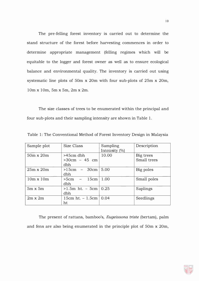
The size classes of trees to be enumerated within the principal and
four sub-plots and their sampling intensity are shown in Table 1 .
Table 1 : The Conventional Method of Forest Inventory Design in Malaysia
Sample plot Size Class Sampling Description Intensity (%)
SOm x 20m >4Scm dbh 1 0 .00 Big trees >30cm - 45 cm Small trees dbh
2Sm x 20m > l Scm - 30cm 5 .00 Big poles dbh
1 0m x 1 0m >Scm - lScm 1 .00 Small poles dbh
Sm x Sm > l .Sm ht. - Scm 0.25 Saplings dbh
2m x 2m lScm ht. - 1 .Scm 0 . 04 Seedlings ht
The present of rattans, bamboo's, Eugeissona triste (bertam) , palm
and fens are also being enumerated in the principle plot of SOm x 20m,