sedimentology and reservoir geology of the betty field .... soc. malaysia, bulletin 25, december...
TRANSCRIPT
Geol. Soc. Malaysia, Bulletin 25, December 1989; pp. 119 - 161
Sedimentology and reservoir geology of the Betty field, Baram Delta Province, offshore Sarawak.,
NW Borneo
H.D. JoHNsoN\ T. Kuun1 AND A DUNDANG2
1 Sarawak Shell Berhad, Lutong, 98009 MIRI, Sarawak, Malaysia.
2 PETRONAS Carigali Sdn. Bhd., (Baram Delta Operations)
P.O. Box 1452, Lutong, 98008 MIRI, Sarawak, Malaysia.
Abstract : The Betty field is a moderate-sized oil field situated in the Baram Delta Province, offshore Sarawak. The field displays many of the characteristics that are typical of this Tertiary deltaic province, notably: (1) the structure is a result of the interaction of delta-related growth faulting and later Pliocene compressional folding, (2) the reservoirs comprise Miocene shallow marine sandstones and shales, which accumulated during repeated phases of small-scale progadation and retrogradation within a major regressive clastic wedge (comprising the wave-dominated palaeo-Baram Delta), and (3) the hydrocarbons occur in numerous vertically-stacked sands separated by sealing shales and trapped by a combination of fault seal and dip closure. This paper discusses these aspects of the Betty field in more detail, particularly the nature and origin of the reservoirs, and relates this geological framework to the field's development and production performance.
Structurally the field is relatively simple, consisting of a NE-SW trending anticline which is bounded to the south by a major E-W trending growth fault (Betty Growth Fault). The anticline is a result of rollover associated with growth faulting combined with Pliocene compressional folding along the NE-SW trending Baronia-Betty-Bokor anticlinal trend.
The Betty reservoirs occur within a ca. 2450 ft (7 4 7 m) thick sequence (between 7200-9650 ft I 2195- 2941 m sub-sea) of Late Miocene, Upper Cycle V clastic sediments, which accumulated in a wave-/storm-dominated, inner neritic to nearshore/coastal environment within the palaeo-Baram Delta complex.
The sand bodies are mainly characterized by numerous, composite and/ or amplified coarsening upward/progradational sequences (ca. 160 ft I 49 m thick) overlain by generally thinner, fining upwardlretrogradationalsequences (ca. 20-50 ft I 6- 15 m thick). The sand bodies are vertically heterogeneous but display high lateral continuity with excellent field-wide correlation, which is consistent with the inferred high wave-energy depositional setting. Vertical heterogeneity is reflected in variations in the thickness and frequency of shale layers, and in the distribution of four distinctive reservoir facies of varying rock quality: (1) poorly stratified sandstone (porosity ca. 23%; permeability ca. 1200 mD), (2) bioturbated sandstone (22%; 500 mD), (3) laminated sandstone (19%; 90 mD), and (4) bioturbated heterolithic sandstone (17%; 50 mD).
Presented at GSM Petroleum Geology Seminar 1986
120 H. D. JoHNsoN, T. Kuuo & A. DuNDANG
The individual Betty reservoirs are interpreted as representing the repeated buildout and gradual retreat of wave-/storm-dominated sand bodies (shoreface and/or shoreface-connected bars). They probably accumulated in a coastal to inner-shelf environment, which was marginal to the axial part of the palaeo-Baram Delta. Complete coastal progradation never occurred in this area in Upper Cycle V times with the environment remaining essentially sub-littoral.
Three main types of vertical facies sequence types are recognized with distinctive gamma ray log profiles. These sequence probably reflect fluctuations in sediment supply and repeated base level changes (mainly subsidence-related), in which the latter was probably significantly influenced by movements along the nearby Betty Growth Fault. The preservation of both progradational and retrogradational deposits, including the development of thick amplified sequences, is indicative of the high subsidence and sedimentation rates within the Baram Delta Province.
Hydrocarbons are trapped within at least twenty-one stacked sand bodies separated by sealing shales. The bulk of the hydrocarbons are encountered in a single structural block where trapping is a result of anticlinal dip closure and updip seal against the Betty Growth Fault. Only minor hydrocarbons are present in subsidiary fault blocks behind the Betty Growth Fault. Within the Betty structure oil-bearing reservoirs decrease in thickness and frequency with depth, while both associated primary gas caps and unassociated gas reservoirs increase in depth (down to 9500 ft I 2895 m sub-sea). This reflects the thermal maturity profile of oil and gas migration in this area; later expulsion and migration of gas has led to the preferential displacement of oil by gas in the structurally deep reservoirs.
Finally, the field's geological model is discussed in relation to production performance and to reservoir management.
INTRODUCTION
The Betty field is situated 40 km offshore Sarawak (Fig. 1) and lies in the south western part of the Baram Delta Province (Fig. 2). The nature and origin of this oil field is typical of many others in this area. The aim of the paper is to outline the main geological characteristics and to demonstrate their impact on the field's development.
More specifically the paper discusses the following topics:
geological setting of the Betty field in relation to the Baram Delta Province,
sedimentological controls on vertical and lateral reservoir quality distribution,
relationship between the sedimentology of the reservoirs and the reservoir geological framework of the field (subdivision, correlation, etc.), and
structural and stratigraphic framework in relation to aspects ofhydrocarbon accumulation, reservoir performance and field development.

0 1!10 iiOOKM ..... _1111:::::::::=:::::1
SOUTH
BETTY FIELD
CHINA SEA
IJ ..
..
0
Figure 1 : Location map of the Betty field.
~" \ / 0 ~? "" " _/ NORTH ~· ~<r; ;.: \ )Z ./ LUCONIA / \ .,<!" / -. J> \":>::_··~a 'J ., / ~~~ v~ /.. ~ .· • ·· ... _ ·....... ,_.. ./. • ···.. / ... ._ .. '• ~ .---1'
....... I."'- . ... .. \ ,} ] '\ .• I .. ~ ... ~ x:. _.·· SABAH
[ \'%. \( ········......... \ ./ ;/ '>..-{.._ .. 0 d< ~; { ]( RIDGES
r -; r\ · lj· \ ·" /••R•o.i /f,Jlf l \ 1: \ ' WEST LUCONIA l\ ·. ,....;'<_, DELTA "i_/ \ [ ~ ~ \ .... .., DELTA -'l'\1 0 ~~~~=~L \:; "'' / }{ 0 F
"<.......,, \ 1'- I [ ..... ....,._.~ _,~/ 11 ~ o '$,r..;,-~~" '\.\ \ ~ r \~'--''-.1'-'"--~ J c; ~ o oo ~~~~~
1" \.t " u ,/......,:: (./ ~~ A ~~ ._.,'-.., '-"""" ~ -P o .a\. \ \{ \-+ ' "'-' r NATUNA ~ \ ~ ~r '~"" LU~~NIA ARCH A \l\~.~~ "\ '~
o ~\ G>IJ\ ~' ~ TATAU WEST
•, \ <g,~ ""'~~""'"HALF GRABENS "\""'> \ ~ ) \ "-... ~ "-....., ""-.., ""'-," ,k 'i- 1 i ~,.........,-....., ~ () \ j \ sA::wAK -...r..IVV\.fVv...""'
~""'- t \. -r--,_
""""' RAJAIVG GROUP -,.....: ~~ .
~ .. '\["•~ .. ~ ~+-../ .. --.._.
o toO Km I ........... '!---,. "
~ --- -. ______ / ~~ .,._ ... KUC- "~~-t
'-- ~ l.J SUNDA , .............. ·....._v- ... ~ SHIELD \...... / --
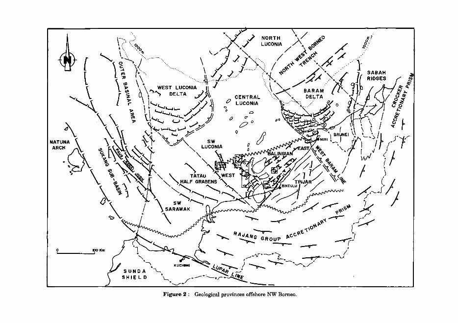
•-......./ ... Figure 2 : Geological provinces offshore NW Borneo.
SEDIMENTOLOGY AND RESERVOIR GEOLOGY OF THE BETTY FIELD 123
GEOLOGICAL SETTING
The Baram Delta Province is located in the northern part of Sarawak and extends north-eastward through Brunei and into the southern part of Sabah (Fig. 2; Scherer, 1980; James, 1984). The province is bounded to the SW by a relatively stable platform characterized by carbonate build-ups (the Central Luconia Province. Fig. 2). A major orogenic belt is situated to theSE, which comprises folded and uplifted Late Eocene deposits. The latter provided the hinterland and source area for the palaeo-baram Delta system. The NE boundary of the province is marked by the wrench fault zones of Central Sabah (Bol and van Hoorn, 1980).
Stratigraphic framework
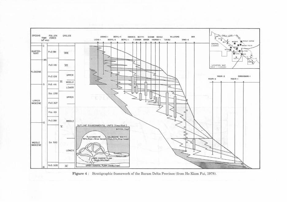
The Barron Delta stratigraphy comprises a thick (ca. 20- 30,000 ft I 6046 -9144 m)'accumulation of Middle Miocene to Recent clastic sediments, mainly comprising coastal to coastal fluviomarine sands and shales, which were deposited in a wave-influenced deltaic environment.
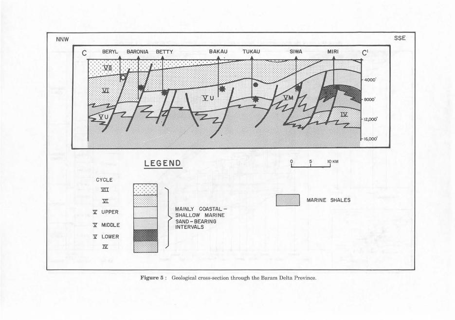
In general the stratigraphic succession comprises a major regressive, sandrich deltaic wedge, which built-out in a north- westward direction (Ho Kiam Fui, 1978). Regression was intermittently interrupted by periods of relatively rapid transgression which resulted in the deposition of laterally extensive marine shales (fig. 4). These shales form the bases of several smaller-scale regressivetransgressive clastic wedges or sedimentary "cycles". There are eight such cycles within the Baram Delta Province (Fig. 4), with the regressive sands within each cycle grading north-westward into neritic, mainly shaly sediments. The Betty field reservoirs are located within the third major regressive interval (ca. 7200 - 9650 ft I 2195 - 2941 m sub-sea) and belong to the Upper Cycle V (Figs. 4 and 5).
Structural framework
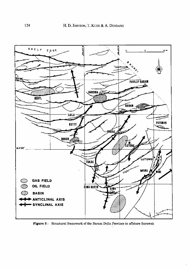
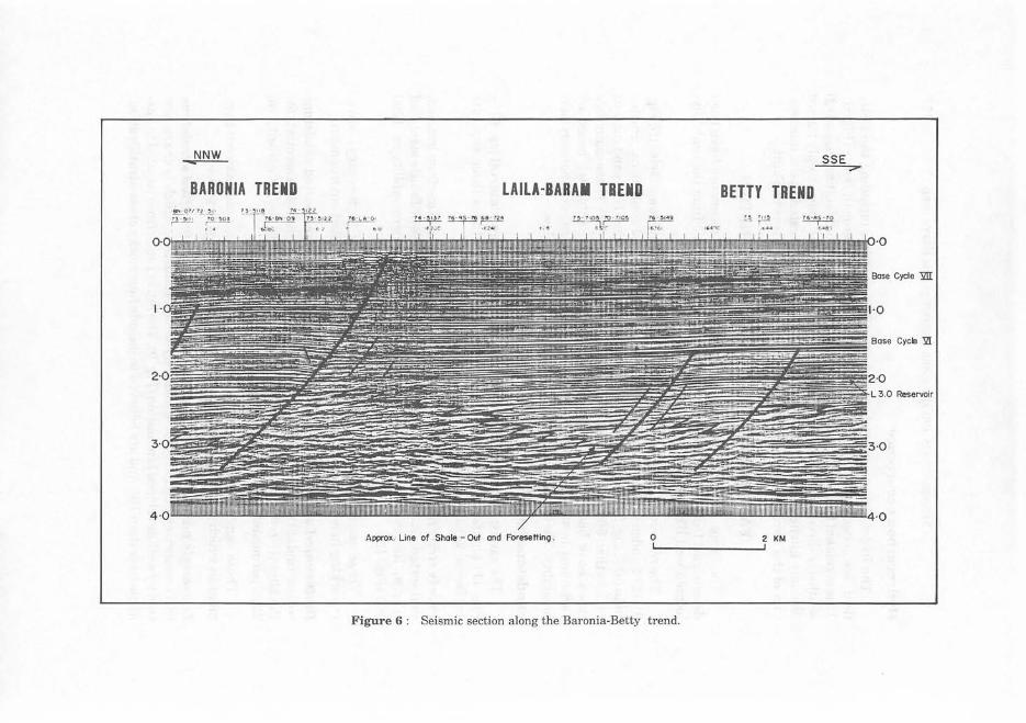
Since the Middle Miocene, the Baram Delta Province has been a rapidly subsiding area, particularly relative to the more stable Central Luconia Province. The boundary between these two areas is marked by the major NW-SE trending West Baram hinge-line which is a possible transform fault (James, 1984). A series of fractures, which are probably also related to basement faulting, are believed to have developed into counter-regional growth faults as sediment loading resulted from the north westward progradation of the Baram Delta. The major growth faults display a curvilinear trend across the basin (Fig. 2). In offshore Sarawak the growth faults are mainly SW-NE oriented in the south, becoming progressively more E-W trending in the north (Fig.3).
In addition to growth fault tectonics, superimposed late Miocene to Pliocene regional compressional deformation also took place. This deformation increases in intensity towards the SE and resulted in the formation of a series of NE-SW tren~g anticlines. These anticlines obliquely intersect the earlier growth faults and it is at these intersection points that the major hydrocarbon accumulations are located (Fig. 3).
124
SHELF
(ffiD GAS FIELD
• OIL FIELD
@ BASIN
H. D. JoHNSON, T. Kuuo & A. DUNDANG
Ill • .. ANTICLINAL AXIS
4 I SYNCLINAL AXIS
Figure 3 : Structural framework of the Baram Detta Province in offshore Sarawak
EPOCHS POLLEN
QUATERNARY
UPPER MIOCENE
MIODLE MIOCENE
TIME ZONES (IO'VRS)
Pv2.581
Sa . 300
CYCLES ZARINA- 1 BERYL-4 BARONIA BETTY• SARAH BAKAU
LYDIA- I BERVL-3 BER'tl...-1 F. BARAM BOKOO HASNAH-1
-=:
=
UPPER
W.LUTilf'«3 MIR1
TUKAU SIWA-4
L OC AT ION MA P sc •~t • z .ooo.ooo
PASIR-2
PASIR-3
Figure 4 : Stra tigraphic framework of the Baram Delta Province (from Ho Kiam Fui, 1978).
ENGKABA/IG-1
PASIR-1
NNW
c BERYL BARONIA BETTY BAKAU
CYCLE
m
:'ill
Y. UPPER
Y. MIDDLE
Y. LOWER
nz:
LEGEND
MAINLY COASTALSHALLOW MARINE SAND- BEARING INTERVALS
TUKAU SIWA MIRI
0 5 IOKM
- MARINE SHALES
Figure 5 : Geological cross-section through the Baram Delta Province.
SSE
4000'
sooo'
12,000'
16,000'

SEDIMENTOLOGY AND RESERVOIR GEOLOGY OF THE BETIY FIELD 127
Hydrocarbon occurrence
The hydrocarbon accumulations in the Baram Delta, including the Betty field, are generally found on the downthrown side of the growth faults (Fig. 6). This is related to a combination of(1) rollover structures and fault seals, and (2) southerly-directed hydrocarbon migration routes from the more deeply buried downdip kitchen areas. The Betty field accumulation is located at the intersection of the Baronia-Betty-Bokor anticline and the Betty Growth Fault.
FACIES AND RESERVOIR CHARACTERISTICS
The facies and reservoir characteristics of the Betty reservoirs have been determined from the ca. 1150 ft (350 m) of continuous core from the centrallylocated well BE-5 (Fig. 7).
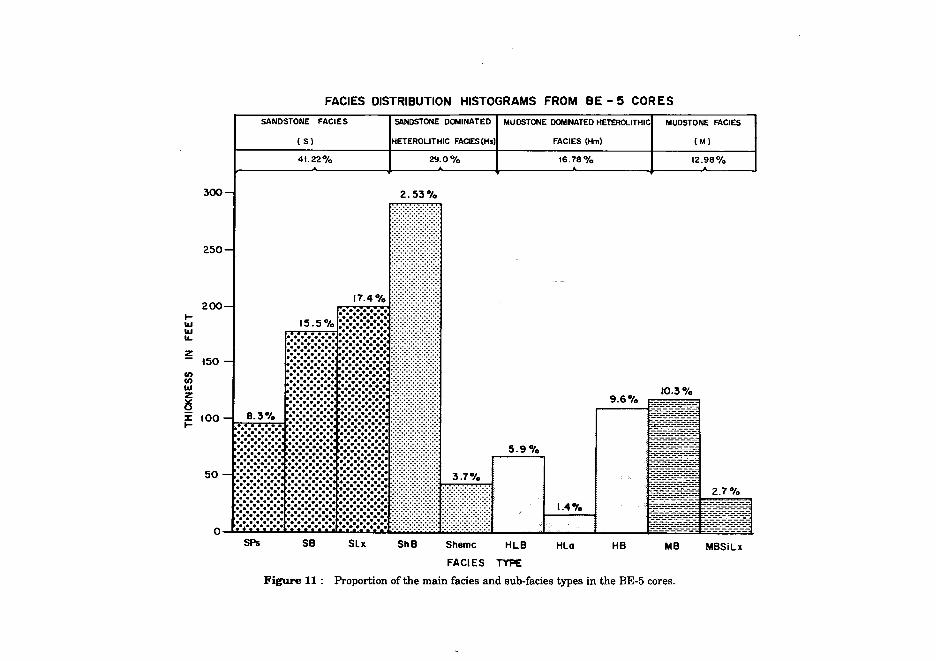
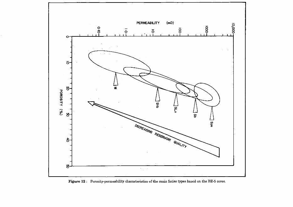
The reservoirs comprise four main facies types: (1) Sandstone facies (S; Fig. 8), (2) Sandstone-dominated heterolithic facies (Hs, sand content ca. greater than 50%; Fig. 9), (3) mudstone-dominated heterolithic facies (Hm, sand content ca.less than 50%; Fig. 10), and ( 4) Mudstone facies (M; Fig. 10). These main rock types have been further subdivided into a total of ten subfacies based on variations in texture, sedimentary structures, bioturation, and porosity/permeability. Their main characteristics are summarized below.
Sandstone facies (S)
The sandstone facies comprises the majority of the cored interval (ca. 41 %; Fig. 11) and is the dominant reservoir rock type. It includes three separate subfacies, which are summarized below (fig. 8).
Poorly stratified sandstone (Sps) consists mainly of fine to medium grained, well sorted, friable sandstone, which is either structureless or faintly stratified (Fig. 8). Reservoir quality is very good: porosity ca. 23%, permeability ca. 1200 mD (Fig. 12).
These sandstone are interpreted as the product of high-energy, wavereworking in a shallow marine (nearshore), wave-dominated environment.
Bioturbated sandstone (Sb) consists of fine grained, well sorted sandstone with abundant vertical and horizontal burrows. The finer grain size accounts for the slightly reduced reservoir quality compares to the Sps facies: porosity ca. 22%, permeability ca. 4 75 mD (Fig. 12).
These sandstones accumulated in a moderate energy, nearshore environment in which the rate of bioturbation exceeded the rate of deposition.
Low-angle/parallel laminated to hummocky cross-stratified sandstone (Slx) comprises fine grained, moderately-sorted sandstone which is characterized by well-developed lamination (Fig. 9). The latter range from parallel to lowangle (less than 10°) and are believed to include hummocky cross-stratification.
NNW ..----- SSE
BARONIA TREND LAILA~BARAI TBEIID BETTY TREND
Approx. Line of Shale -Out and Foresetting. 0 2 KM
Figure 6 : Seismic section along the Baronia-Betty trend.
:z:
-
SEDIMENTOLOGY AND RESERVOIR GEOLOGY OF THE BETTY FIELD 129
UPPER MIOCENE
UPPER CYCLE I
FLUVIOMARINE
,...
AGE
STRATIGRAPHY
,... ::::j
""a::z: == =,... ::::!:!= ,... C')
rnc:; > ,...
c; PERMEABILITY 8 MILLIDARCIES §
Figure 7: Type log of the Upper Miocene, Upper Cycle V interval in the Betty field (well BE-5)
130 H. D. JoHNSON, T. Kuun & A. D UNDANG
SAND FACIES TYPES
BETTY- 5 S•\ I{AWM\ SH ELL Ur;JU IAI)
C 13 T 251 C 15 T 289 C4T6l C4T64
765 1.3- 7653. 10" 7653. 10 -7856.8"
0
1
OS
3
Figure 8 : Core photographs illustrating the characteristics of the main sand facies type
0
0'
o;
2
...
3
SEDIMENTOLOGY AND RESERVOIR GEOLOGY OF TH E B ETTY FIELD
SANDS AND ASSOCIATED HETEROLITHIC FACIES TYPES
BETTY - 5 C 12 T 224 C Sl T UIO
8099.8- 81 0 2.8 " 7512 1.0 - 711 23.51"
C 15 T 288
8<'78.7 - 828 1.7"
~AAAWAK ~U:U IJI:UHAD
C 2 T 16
t.s211 -1s2e.r
131
Figure 9 : Core photographs illustrating the characteristics of the sand and sand-dominated heterolithic facies types
132 H. D . JoHNSON, T. K uuo & A. D uNDANG
MUD AND ASSOCIATED HETEROLITHIC FACIES
BETTY- 5 ~A I IA\Vi\K .,II(LllU:.Hi ll\0
Firure 10 : Core photographs illustrating the characteristics of the mud and mud·dominatod hoterolithic facies typos
300-
250-
200-..... 1&1 1&1 II..
z - tSO-fl) fl) 1&1 z lS i: tOO-.....
so-
FACIES DISTRIBUTION HISTOGRAMS FROM BE- 5 CORES
SANDSTONE FACIES SANDSTONE DOMINATED I MUDSTONE DOMNATED HETERa...ITHICI
HETEROLITHIC FACIES(Hs) FACIES (Hm) ( S)
41.22% 29.o% I t6.78%
2.53%
17.4%'!!!! !!1!11!
8.3%
::::::::::::: ~=~=~=~=~=~=~l=~=~=~=~=~=~==l~fffffl .•.•.•.•.•.•.• .•.•.•.•.•.•. •.•.•.•.•.•.•. :·:·:·:·:·:·:·:·:·:·:- 5. 9 Ofo ,::::::::::::: ::::::::::::: :::::::::::::: ~~~~~~~~~~~~~~~~~~~~~~ :::::::::::::: ::::::::::::: :::::::::::::::::::::::::::::::::::: 3 .7°/o '•············ ···•·····•··• ••··••·••·•··• :-:·:·:-:-:-:-:-:-:-: ·.·.·:·:-:-:-:-:-:-:-: . ·.·.········~· ··········•·• ·•·•·•·•·•·•·• -:-:-:-:-:-:-:-:-:-:- :-:-:-:-:-:-:-:-:-:-:- :
1.4.,.
9.6%
MUDSTONE FACIES
(M)
12.98%
10.3%
o~~~~~~~~~~~~~~L---~~~~----~~~====~ SPs SB SLx ShB Shemc HLB HLa HB MB MBSiLx
FACIES TYPE
Figure 11 : Proportion of the main facies and sub-facies types in the BE-5 cores.
9 i5 6
PERMEABILITY (mD)
0 8 § 0 I I I I I I I I I I I I I I I I I I I .I I I I I I I I I I I I
i5
"'0 e1 0
~ (I)
=i -<
~ ~·
8
8J---------------------~------~----------~
Figure 12 : Porosity-permeability characteristics of the main facies types based on the BE-5 cores.
SEDIMENTOLOGY AND RESERVOIR GEOLOGY OF THE BETTY FIELD 135
The fine grain size and abundant lamination result in relatively moderate reservoir quality: porosity ca. 19%, permeability ca. 90 mD (Fig.12).
These sandstones are interpreted as high-energy storm-deposits,. which were deposited rapidly, probably below fair-weather wave-base, in a nearshore to inner neritic environment.
Sandstone-dominated heterolithic facies (Sh)
The sandstone-dominatedhetero:iithic facies consists of sandstones with significant proportions of either interstitial (dispersed) or interbedded clays (sand content ca. 50- 90%). This reser\roir rock type comprises ca. 29% of the cored interval (Fig. 11) and is divided into two subfacies.
Bioturbated heterolithic.sandstone (Shb) is a common rock type (25% of cored interval) consisting offme grained, slightly argillaceous sandstone which has been completely homogenized b y extensive bioturbation (fig. 9). Biogenic mottling is the dominant macroscopic texture with frequent clay-lined burrows. The high proportion of dispersed clay is the main cause of the relatively low reservoir quality: porosity ca. 17%,permeability ca. 52 mD (Fig. 12).
This rock type was deposited in a low-energy inner neritic environment in which the rate of bioturbation exceeded the rate of deposition. ,. Interbedded sandstone and shale (Shemc) is a distinctive but subordinate rock type (ca. 4% of cored interval). It comprises individual sandstone beds (0.4 .... 3 ft I 12 em - 1 m thick) which display the following features: (i) erosive base, (ii) clay clasts, (iii) low-angle to ripple lamination, and (iv) bioturbated or sharp tops. These 'beds occur in single and amalgamated units and may be overlain by cm~thick mudstone layers. Reservoir quality is highly variable, but generally moderate: porosity ca. 1?%, permeability 139 mD (Fig. 12).
This type of deposit is interpreted as an alternation of storm-generated sandstone beds interbedded with post-storm and fair weather mudstones (Johnson and Baldwin, 1986). ·
Mudstone-dominated heterolithic facies (Hm)
The mudstone-dominated heterolithic facies comprises various mudstone lithologies (ranging from laminated t9 bioturbated) with up to 50% sandstone intercalations (Fig. 10). There separate subfacies have been identified (bioturbated, lenticular and laminated), which together constitute ca. 17% of the total ctired interval in BE-5 (Fig. 11). These lithologies form the intra-reservoirs shale layers (as seen on GR logs) which occur within the main reservoir intervals. This facies is generally non-reservoir but minor porosity/permeability occurs in some of the sandier intervals.
Microfauna indicates deposition in a fluviomarine coastal to inner neritic environment.
136 H. D. JoHNSON, T. Kuuo & A. DuNDANG
Mudstone facies (M)
The mudstone facies (Fig. 10) comprises ca. 13% of the total cores interval (Fig. 11) and is the dominant rock type of the inter-reservoir shale units (Fig. 4). This facies forms the main sealing shale-layers within the Betty field.
Microfauna is often sparse but indicates deposition in a fluviomarine coastal to inner neritic environment.
DEPOSITIONAL MODEL
In general the Upper Cycle V reservoirs in the Betty field can be interpreted as having accumulated in a sand-rich coastal to fluviomarine environment. This sand-dominated sequence shales-out basinwards in the Beryl area (ca. 10- 30. km NW), while coastal plain equivalents may be present along the Tukau-West Lutongtrend (ca. 30 km to SE; Fig. 5). The main reservoir sands of the Betty field, therefore, accumulated within a board, sand-rich, shallow marine zone which was several 10's km, possibly up to 70 km, wide.
Sand body development in the Betty field, and other parts of the Delta Province, was strongly influenced by the following factors: (1) high sedimentation rates, (2) high subsidence rates (enhanced adjacent to growth faults), (3) frequent base-level fluctuations (in which rates of eustatic sea-level changes were subordinate to basin subsidence rates, Hageman, 1987), and (4) a high wave-energy regime.
The basic element of the Betty field reservoirs are coarsening upward sand bodies, which formed in a shallow marine environment mainly in response to wave-/storm-dominated processes (Elliot, 1986; Johnson and Baldwin, 1986). Individual sand bodies display the following features: (1) sharp basal contact with the underlying mudstones, (2) abrupt initial coarsening-upward trend, (3) predominance of storm-generated sandstone beds withhigh-energywave-formed sedimentary structures in the lower part of the coarsening upward sequences and only minor bioturbation, (4) increased grain-size, sortiD.g and degree of bioturbation together with a corresponding decrease in stratification and clay content, and (5) coarse, poorly stratified sands at the top, occasionally with ·shell lags.
Features notably absent from these sand bodies include the following: (1) no evidence of tidal activity (lack of clay drapes and current-formed structures), (2) lack of emergence (no coals or rootlet horizons), and (3) absence of structures characteristic of beach foreshore/upper shoreface environments.
The absence of these features seems to preclude the origin of these coarsening upward sand bodies as ( 1) axial/proximal delta frontlwave-dominated mouth bars, (2) tidal sand bars, and (3) offshore to beach/foreshore sequence (cf. Elliot, 1986 a and b).
SEDIMENTOLOGY AND RESERVOIR GEOLOGY OF THE BETTY FIELD 137
The remaining possible interpretations for these sand bodies include the following: (1) marginal delta-front sands, (2) stacked inner-shelf to lower/middle shoreface sequences, and (3) shoreface-connected shelf sand bars. It has not been possible to distinguish between these possibilities.
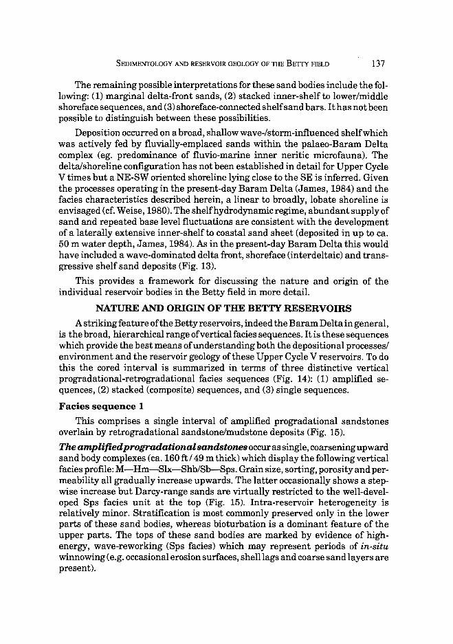
Deposition occurred on a broad, shallow wave-/storm-influenced shelf which was actively fed by fluvially-emplaced sands within the palaeo-Baram Delta complex (eg. predominance of fluvio-marine inner neritic microfauna). The delta/shoreline configuration has not been established in detail for Upper Cycle V times but a NE-SW oriented shoreline lying close to the SE is inferred. Given the processes operating in the present-day Baram Delta (James, 1984) and the facies characteristics described herein, a linear to broadly, lobate shoreline is envisaged (cf. Weise, 1980). The shelfhydrodynamic regime, abundant supply of sand and repeated base level fluctuations are consistent with the development of a laterally extensive inner-shelfto coastal sand sheet (deposited in up to ca. 50 m water depth, James, 1984). As in the present-day Baram Delta this would have included a wave-dominated delta front, shoreface (interdeltaic) and transgressive shelf sand deposits (Fig. 13).
This provides a framework for discussing the nature and origin of the individual reservoir bodies in the Betty field in more detail.
NATURE AND ORIGIN OF THE BETTY RESERVOmS
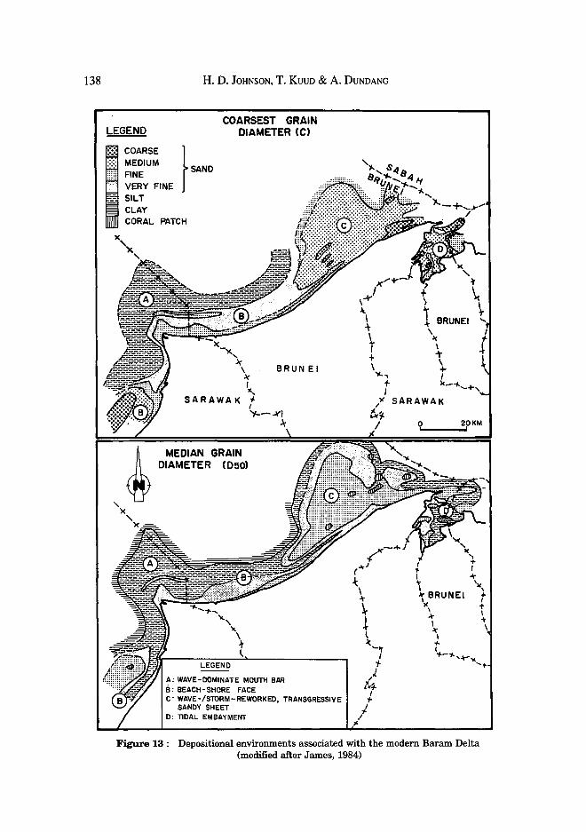
A striking feature of the Betty reservoirs, indeed the Baram Delta in general, is the broad, hierarchical range of vertical facies sequences. It is these sequences which provide the best means of understanding both the depositional processes/ environment and the reservoir geology of these Upper Cycle V reservoirs. To do this the cored interval is summarized in terms of three distinctive vertical progradational-retrogradational facies sequences (Fig. 14): (1) amplified sequences, (2) stacked (composite) sequences, and (3) single sequences.
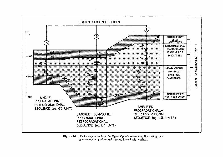
Facies sequence 1
This comprises a single interval of amplified progradational sandstones overlain by retrogradational sandstone/mudstone deposits (Fig. 15).
Theamplifiedprogradationalsandstonesoccur as single, coarsening upward sand body complexes (ca. 160ft I 49 m thick) which display the following vertical facies profile: M-Hm-Slx-Shb/Sb-Sps. Grain size, sorting, porosity and permeability all gradually increase upwards. The latter occasionally shows a stepwise increase but Darcy-range sands are virtually restricted to the well-developed Sps facies unit at the top (Fig. 15). Intra-reservoir heterogeneity is relatively minor. Stratification is most commonly preserved only in the lower parts of these sand bodies, whereas bioturbation is a dominant feature of the upper parts. The tops of these sand bodies are marked by evidence of highenergy, wave-reworking (Sps facies) which may represent periods of in-situ winnowing (e.g. occasional erosion surfaces, shell lags and coarse sand layers are present).
138 H. D. JoHNSON, T. Kuuo & A. DuNDANG
COARSEST GRAIN DIAMETER (C)
SARAWAK
MEDIAN GRAIN DIAMETER (D50)
LEGEND
BRUNEI
A: WAVE-DOMINATE MOUTH BAR B: BEACH-SHORE FACE C: WAVE-/STORM-REWORKED, TRANSGRESSIVE
SANDY SHEET D: TIDAL EMBAYMENT
0 20KM
Figure 13 : Depositional environments associated with the modern Baram Delta (modified after James, 1984)
FT 0
100
FACIES SEQUENCE TYPES
INNER NERITIC SANDSTONES
PROGRADATIONAL COASTAL/ SHOREFACE
SANDSTONES
300 SINGLE TRANSGRESSIVE
SHELF MUDSTONES
PROGRADATIONALRETROGRADATIONAL SEQUENCE (eg. M3 UNIT)
STACKED (COMPOSITE) PROGRADATIONAL -RETROGRADATIONAL SEQUENCE (eg. L7 UNIT)
AMPLIFIED PROGRADATIONALRETROGRADATIONAL SEQUENCE (eg. L3 UNITS)
Figure 14 : Facies sequences from the Upper Cycle V reservoirs, illustrating their gamma ray log profiles and inferred lateral relationships.
en ~ ~ z Q lei 0 ~ ~ en LLI
~ u:
a:
L3.0
GAMMA RAY
DOMINANT STRUCTURES
( =) POORLY STRATIFIED
~ HUMMOCKY ~ STRATIFICATION
4}> BIOTURBATION
LITHOLOGY
[;:::::: [ SANDS
[~ / I SHALES
LITHOLOGY AND
STRUCTURES
PERMEABILITY I mOl
1000
MAIN FACIES
1. POORLY STRATIFIED SANDSTONE
2 . BIOTURBATED SANDSTONE
BIOTURBATED HETEROUTHIC 3. SANDSTONE
4 . LAMINATED SANDSTONE
5 . SHALE S
FACIES INTERPRETATION
SINGLE (AMPLIFIED l
PROGRADATIONAL
++-r-.H SHOREFACE/DELTA FRONT
SEQUENCE
SEQUENCES
\j COARSENING UPWARD SEQUENCE
/J. FINING UPWARD SEQUENCE
Figure 15 : Sedimentological and reservoir characteristics of facies sequence 1 (single amplifi ed progradational I retrogradational sequence).
SEDIMENTOLOGY AND RESERVOIR GEOLOGY OF THE BETTY FIELD 141
Retrogradational sandstone/mudstone deposits from extremely heterogeneous intervals characterized by rapid alternations of sandstone beds (2 - 10 ft I 0.6 - 3 m thick) and mudstone layers (Fig. 15). Sand content is lower than in the progradational sequences and there is an overall upward decrease in reservoir quality. In detail these intervals may include both small-scale coarsening and fining upward sequences, which are separated by laterally extensive shales (correlatable fieldwide).
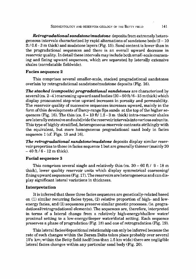
Facies sequence 2
This comprises several smaller-scale, stacked progradational sandstones overlain by retrogradational sandstone/mudstone deposits (Fig. 16).
The stacked (composite) progradational sandstones are characterized by several (ca. 2 -4 ) coarsening upward sand bodies (20-50ft I 6- 15m thick) which display pronounced step-wise upward increases in porosity and permeability. The reservoir quality of successive sequences increases upward, mainly in the form of thin developments of Darcy-range Sps sands at the top of the higher sequences (Fig. 16). The thin (ca. 5-10ft/ 1.5- 3m thick) intra-reservoir shales are laterally extensive and subdivide the reservoir intervals into various subunits. This type of highly stratified, heterogeneous reservoir contrasts strikingly with the equivalent, but more homogeneous progradational sand body in facies sequence 1 (cf. Figs. 15 and 16).
The retrogradational sandstone/mudstone deposits display similar reservoir properties to those in facies sequence 1 but are generally thinner (mainly 20 - 40 ft I 6 - 12 m thick).
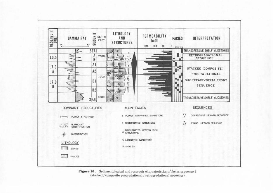
Facial sequence 3
This comprises several single and relatively thin (ca. 30-60 ft I 9- 18m thick), lower quality reservoir units which display symmetrical coarsening/ fining upward sequences (Fig. 17). The reservoirs are heterogeneous and can display significant lateral variations in thickness.
Interpretation
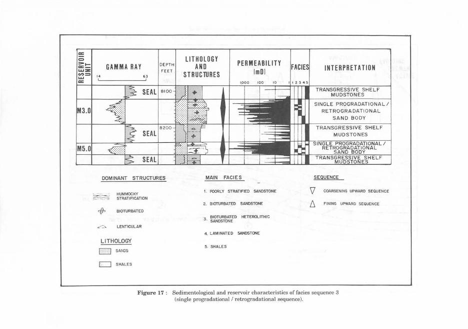
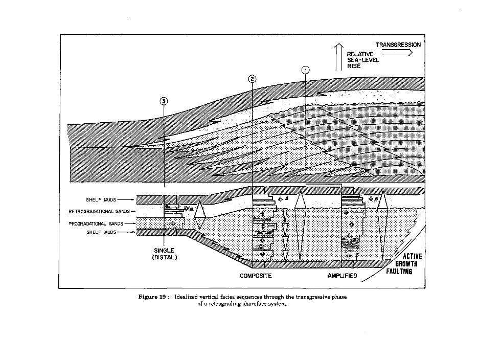
It is inferred that these three facies sequences are genetically-related based on ( 1) similar recurring facies types, (2) relative proportion of high- and lowenergy facies, and (3) sequences preserve similar genetic processes. (ie. progradational/retrogradational elements). The sequences are, therefore, interpreted in terms of a lateral change from a relatively high-energy/shallow water/ proximal setting to a low-energy/deeper water/distal setting. Each sequence preserves a phase of progradation (Fig. 18) and one of retrogradation (Fig. 19).
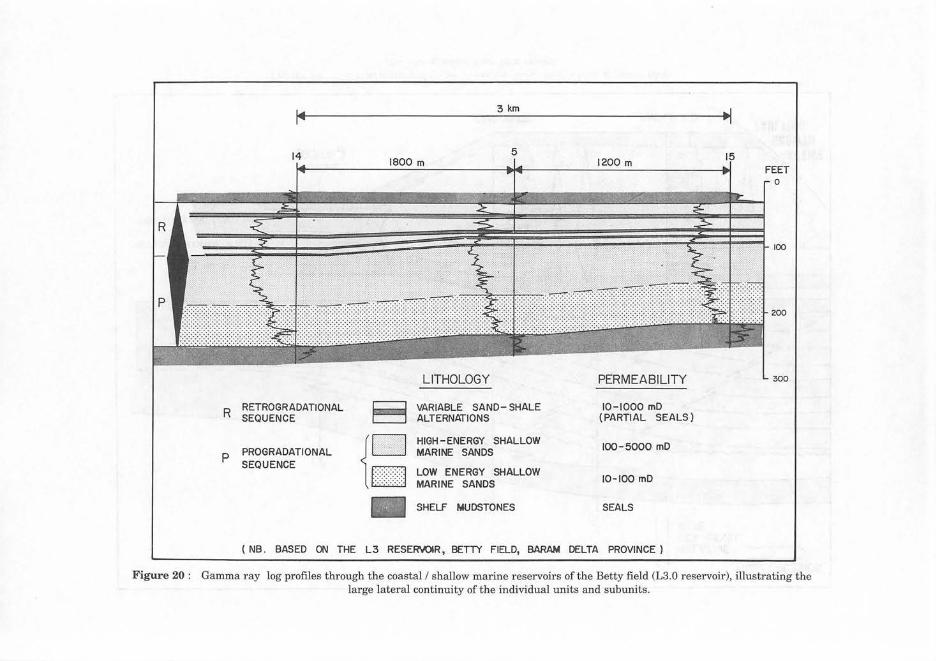
This lateral facies/depositional relationship can only be inferred because the rate of such changes within the Baram Delta takes place probably over several 10's km; within the Betty field itself (less than 1.5 km wide) there are negligible lateral facies changes within any particular sand body (Fig. 20).
a:: c
~;; GAMMA RAY LITHOlOGY
AND STRUCTURES
PERMEABILITY I mOl INTERPRETATION
l6.5
l7.0 B
14
DOMINANT STRUCTURES
(=) PCXJRLY STRATIFIED
HUMMOCKY STRATIFICATION
+ BIOTURBATION
LITHOLOGY
[2J SANDS
16'1· ) SHALES
1000
MAIN FACIES
1. PCXJRLY STRATIFIED SANDSTOIIE
2 . BIOTURBATED SANDSTONE
3. BIOTURBATED HETERO...ITHlC SANDSTONE
4. LAMINATED SAHlSTONE
5.SHALES
STACKED (COMPOSITE)
PROGRADATIONAL
SHOREFACE/DELTA FRONT
SEQUENCE
TRANSGRESSIVE SHELF MUDSTONES
SEQUENCES
COARSENING UPWARD SEQUENCE
FINING UPWARD SEQUENCE
Figure 16 : Sedimentological and reservoir characteristics of facies sequence 2 (stacked I composite progradational I retrogradational sequence).
a::
= =-t-=-LLI :z: c;:):::;) LLI a::
3.0
M5 .0
GAMMA RAY DEPTH
F E ET 14 63
SEAL 8 100
8200
SEAL
SEAL
DOMINANT STRUCTURES
HUMMOCKY STRATIFICATION
4)=> BIOTURBATED
c--'- LENTICULAR
LITHOLOGY
I:::: :::J SANDS
CJ SHALES
LITHOLOGY AND PERMEABILITY
lmDI STRUClURES 1,000
MAIN FACIES
1. POORLY STRATIFIED SANDSTONE
2 . BIOTURBATED SANDSTONE
4. LAMINATED SANDSTC't<E
5. SHALE S
INTERPRETATION
TRANSGRESSIVE SHELF MUDSTONES
SINGLE PROGRADATI ON AL I
RETR OGRA DATI ONAL
S AND BODY
TRANSGR ESSIVE SHELF
I
SEQUENCE
COARSENING UPWARD SEQUENCE
/j, FINING UPWARD SEQUENCE
Figure 17 : Sedimentological and reservoir characteristics of facies sequence 3 (single progradational I retrogradational sequence).
MEAN FAIR WEATHER WAVE BASE
SINGLE (DISTAL)
PROGRADATION
COMPOSITE
Figure 18 : Idealized vertical facies sequences through the regressive phase of a variably subsiding and prograding wave-dominated shoreface.
n
RETROGRADATIONAL SANDS-
PROGRADATIONAL SANDS-
SHELF MUDS---~~~~~~~
Figure 19 : Idealized vertical facies sequences through the transgressive phase of a retrograding shoreface system.
TRANSGRESSION
RELATIVE SEA-LEVEL RISE
R RETROGRADATIONAL SEQUENCE
p PROGRADATIONAL SEQUENCE
3 km
LITHOLOGY
VARIABLE SAND- SHALE ALTERNATIONS
HIGH-ENERGY SHALLOW MARINE SANDS
LOW ENERGY SHALLOW MARINE SANDS
SHELF MUDSTONES
PERMEABILITY
10-1000 mD (PARTIAL SEALS)
100-5000 mD
10-100 mD
SEALS
( NB . BASED ON THE L3 RESER'>'OIR, BETTY FIELD, BARAM DELTA PROVINCE)
0
100
200
300
Figure 20 : Gamma ray log profiles through the coastal I shallow marine reservoirs of the Betty field (L3.0 reservoir) , illustrating the large lateral continuity of the individual units and subunits.
SEDIMENTOLOGY AND RESERVOIR GEOLOGY OF THE BETIY FIELD 147
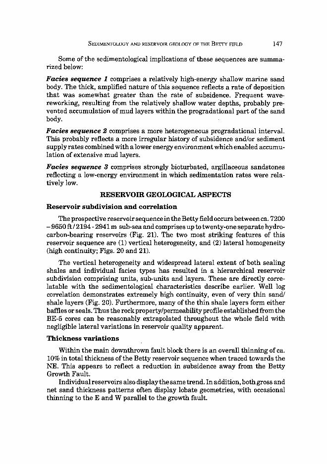
Some of the sedimentological implications of these sequences are summarized below:
Facies sequence 1 comprises a relatively high-energy shallow marine sand body. The thick, amplified nature of this sequence reflects a rate of deposition that was somewhat greater than the rate of sub~idence. Frequent wavereworking, resulting from the relatively shallow water depths, probably prevented accumulation of mud layers within the progradational part of the sand body.
Facies sequence 2 comprises a more heterogeneous progradational interval. This probably reflects a more irregular history of subsidence and/or sediment supply rates combined with a lower energy environment which enabled accumulation of extensive mud layers.
Facies sequence 3 comprises strongly bioturbated, argillaceous sandstones reflecting a low-energy environment in which sedimentation rates were relatively low.
RESERVOm GEOLOGICAL ASPECTS
Reservoir subdivision and correlation
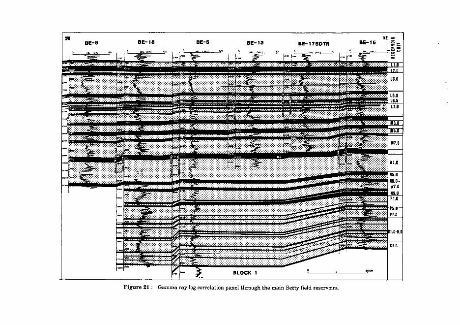
The prospective reservoir sequence in the Betty :field occurs between ca. 7200 -9650 ft/2194- 2941 m sub-sea and comprises up to twenty-one separate hydrocarbon-bearing reservoirs (Fig. 21). The two most striking features of this reservoir sequence are (1) vertical heterogeneity, and (2) lateral homogeneity (high continuity; Figs. 20 and 21).
The vertical heterogeneity and widespread lateral extent of both sealing shales and individual facies types has resulted in a hierarchical reservoir subdivision comprising units, sub-units and layers. These are directly correlatable with the sedimentological characteristics describe earlier. Well log correlation demonstrates extremely high continuity, even of very thin sand/ shale layers (Fig. 20). Furthermore, many of the thin shale layers form either baftles or seals. Thus the rock property/permeability profile established from the BE-5 cores can be reasonably extrapolated throughout the whole field with negligible lateral variations in reservoir quality apparent.
Thickness variations
Within the main downthrown fault block there is an overall thinning of ca. 10% in total thickness of the Betty reservoir sequence when traced towards the NE. This appears to reflect a reduction in subsidence away from the Betty Growth Fault.
Individual reservoirs also display the same trend. In addition, both gross and net sand thickness patterns often display lobate geometries, with occasional thinning to the E and W parallel to the growth fault.
BE-8 BE-18 BE-5 IE Sl
BE-13 BE-17SDTR BE-15
0 "!""'
Figure 21 : Gamma ray log correlation panel through the main Betty field reservoirs.
SEDIMENTOLOGY AND RESERVOIR GEOLOGY OF THE BETTY FIELD 149
Structure and hydrocarbon distribution
The Betty field is a gently-dipping (ca. 8°), dome-shaped, rollover anticline (Fig. 22) situated at the intersection of the Baronia-Betty-Bokor anticlinal trend and the north hading Betty Growth Fault (Fig. 3).
The growth fault forms the main updip seal for hydrocarbon trapping and it also controlled sediment accumulation, with a significantlythicker succession of sediment on the downthrown side ofthe fault (average growth index 2.70). The closely associated Betty Boundary Fault (Fig. 22) appears to be a secondary split on the upthrown side of the main growth fault. In this latter area correlation shows similar sediment thicknesses on either side of the Betty Boundary Fault, thereby demonstrating that it is not a growth fault (Fig. 23).
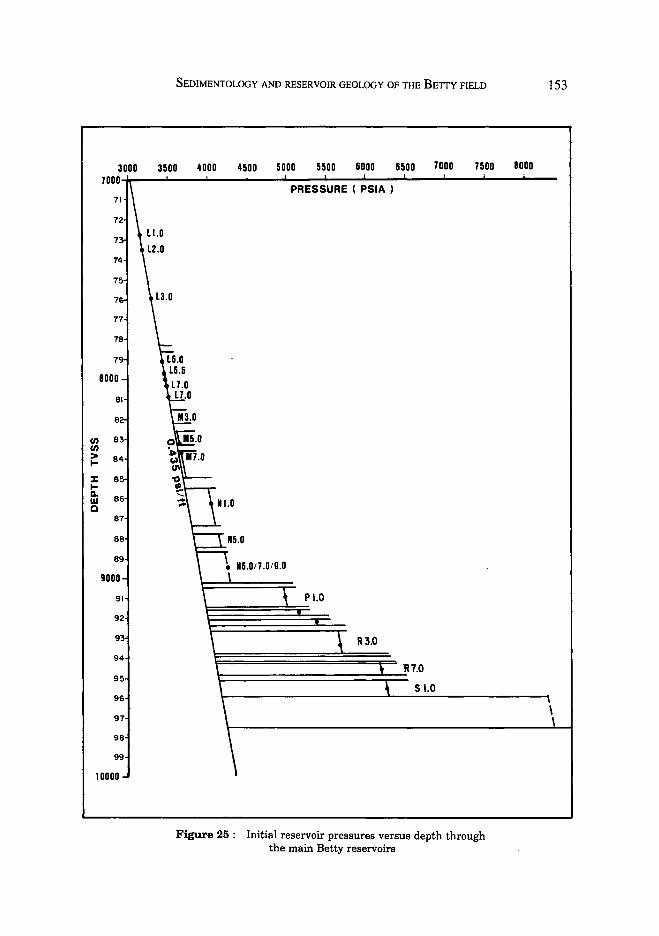
The main hydrocarbon accumulation is situated on the downthrown side of the Betty Growth Fault (Fig. 24). The accumulation comprise a series of stacked reservoirs each separated by sealing shales. There is a stepwise increase in reservoir pressure with depth (Fig. 25). This is also accompanied by an increase in gas cap size, an increase in the frequency of gas-bearing reservoirs and a corresponding decrease in oil-bearing reservoirs with depth.
Only minor hydrocarbons are found on the upthrown side ofthe growth fault (Block 2), confirming the effectiveness of this fault as a seal (Fig. 24). The overall hydrocarbon distribution suggests a southerly-directed primary migration path along the Baronia-Betty-Bokor anticlinal trend. Leakages into Block 2 may have occurred at the branch-off points of the Betty Growth Fault and the Betty Boundary Fault (Fig. 22).
FIELD APPRAISAL AND DEVELOPMENT
Betty field history
The Betty field is one of nine commercial oil fields currently under development in the Sarawak part of the Baram Delta Province (Fig. 3). The field was discovered in 1967/68 by the near crestal well BE-l. This was followed up by three largely unsuccessful exploratory appraisal wells (BE-2 in 1968, BE-3 in 1973 and BE-4 in 1975) drilled on and around the Betty West satellite structure, some 12 km west of the BE-l accumulation.
The Betty field is of moderate size (total recoverable reserves ca. 105 MMSTB) and is being developed from a single, 24-slot, centrally-located drilling platform (BEDP-A), which was installed in 1978 (Fig. 22). Initial drilling comprised a vertical appraisal/development well (BE-5), which extensively cored the main reservoir interval, and was followed by eight additional development wells. a second round of development drilling took place in 1984/85 (one appraisal well/four development wells) and a third round followed in 1987/88 (ten development well/three workovers).
LEGEND -[ililill] GAS ~- ~ .. OIL .
owe OIL WATER CONTACT
GOC GAS OIL CONTACT
A~ LINE OF CORRELATION (Ref. Fig. 15)
0 I~
0 3o0o FT.
Figure 22: Structure map of the top L3.0 reservoir.
SEDIMENTOLOGY AND RESERVOIR GEOLOGY OF THE BETIY FIELD
BETTY OOWNTHROWN BLOCK
BE-~
....
...J ~
cl ~
X .... :I 0 a::
"' >-.... .... LtJ CD
BE-14
> a:: cl 0 z ::J 0 CD
> J: LtJ CD
BE-ll
0
BOKOR BLOCK
B0-2
3000 FT
151
Figure 23 : Well log correlation from the Betty downthrown block, across the Betty Growth Fault and Betty Boundary Fault, and into the Bokor block (to 8)
N BEDP- A BE-5
TO. 967'iss
86 "SHALE-OUT" LINE ---z ____ ~::::.-~~--~ ---=--.e:::...-- -- -=- ------
UNDERCOMPACTED PRO-DELTA SHALES
BLOCK I
LEGEND
!IT] GAS
D OIL IZ2:I POSSIBLE OIL ~ HYDROCARBON ~WATER
s
e PRODUCING RESERVOIRS
0 625 ~FT.
Figure 24 : N-S structural cross-section through the Betty field illustrating hydrocarbon distribution.
92
9
94
95
96
97
98
99
10000
SEDIMENTOLOGY AND RESERVOIR GEOLOGY OF THE BE1TY FIELD
3500 4000 uoo 5000 5500 6000 6500 7000 7500 BODO
PRESSURE ( PSIA )
p 1.0
Figure 25 : Initial reservoir pressures versus depth through the main Betty reservoirs
153
\ \

154 H. D. JoHNSON, T. Kuuo & A. DuNDANG
The discovery, appraisal and initial development of the filed was undertaken by Sarawak Shell Berhad up to august 1988. Subsequently, it is now being developed by a joint venture (Baram Delta Operations) between PETRONAS Carigali (Operator) and Sarawak Shell Berhad.
Reservoir performance
The main development activity has been directed towards the shallower oilbearing reservoirs and, as discussed earlier, has been conducted in a phased manner. The three main development campaigns and associated production data enable observations to be made on the relationship between the geological model and :r:eservoir performance.
Production began at the end of 1978 and the reservoirs can be classified in terms of their main drive mechanisms as follows: (1) strong water drive reservoirs (L3.0 and L 7 .0), (2) weak/moderate water drive reservoirs (L6.0, L6.5 and M7.0), and (3) weak water drive reservoirs (M3.0, M5.0 and Nl.O). In the latter two cases solution gas and gas cap expansion provide additional reservoir energy.
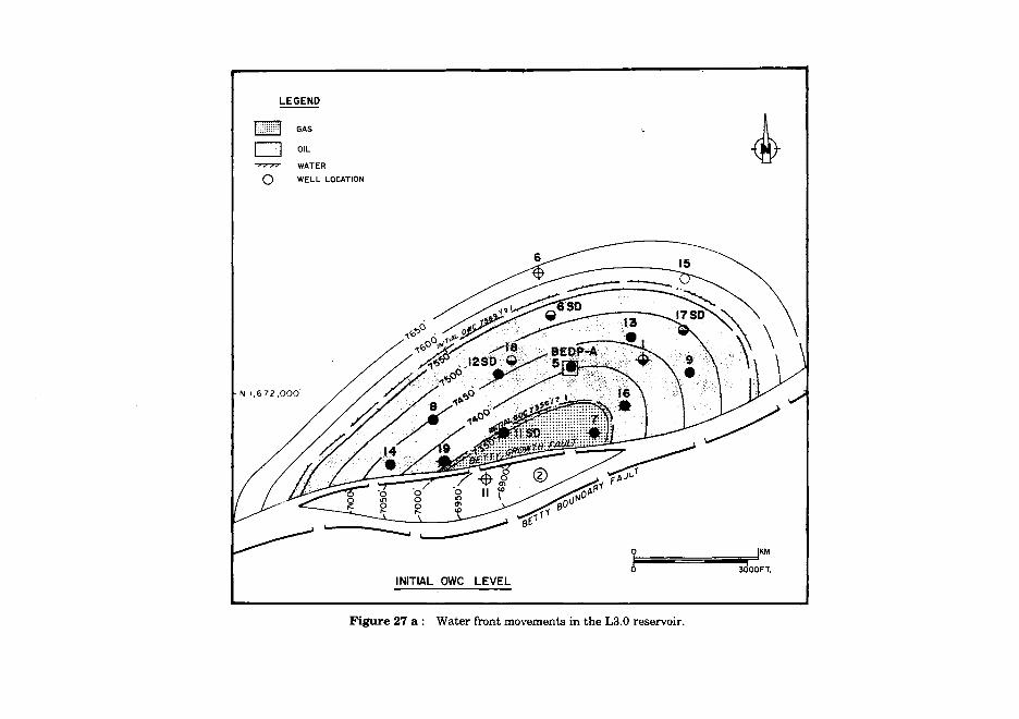
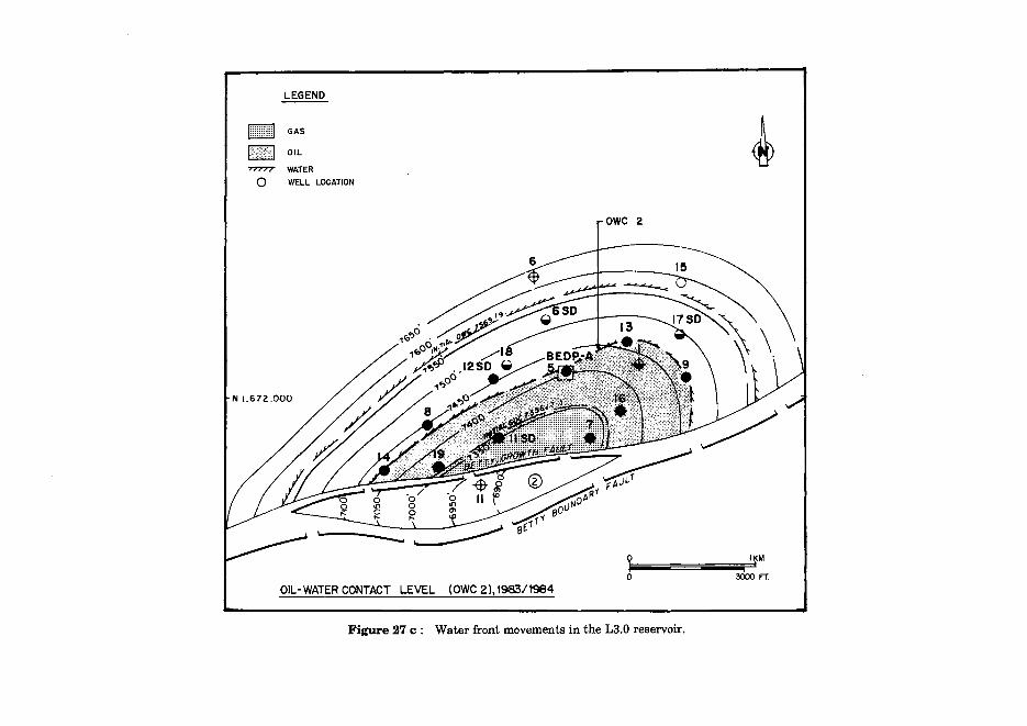
The results of infill wells demonstrate that prediction of gas/oil and oil/water contacts is difficult due to the composite nature of the reservoirs. Most significant is the variable vertical distribution of high and low quality reservoirs and the field-wide lateral extent of many of the impermeable shale layers. This has a direct impact on reservoir performance. Water production, for example, is particularly sensitive to rock quality (permeability), drainage point location, withdrawal rate and differential production, including localized water fingering along high permeability zones. This situation is apparent in the L3.0 reservoir (Fig. 26) where there is preferential upward movement of the oil/water contact within, and local increased water production from, the higher quality reservoir units (A, B, C, and D). In contrast, there is negligible contact movement within the lower quality E unit, which is relatively undrained (Fig. 26). In the case of units A, B, and C preferential water flooding must be within a few thin, high permeability layers. More uniform water encroachment within the relatively homogeneous unit D is anticipated.
Lateral variations in water front encroachment is also apparent (Fig. 27). In the L3.0 reservoir, for example, water production started in wells BE-8 and -12 in 1981/1982 but not in wells BE-9 and -13 which are located on the eastern flank of the field and were completed within the same unit and at similar structural levels. It was only later in 1983/84 that water production began to show up in BE-9 and -13. This delay in water production on the eastern flank is due mainly to the fewer drainage points compared to the west flank.
Completion strategy
The detailed reservoir subdivision based on the sedimentology and reservoir geological framework has resulted in a more optimal selection of completion intervals during the second phase of development drilling.

LEGEND
D OIL
[llijJ GAS
~ SHALE -~ WATER
I PERFORATION
NOTE .
OWC I : Contact level in 1981
owe 2 : COntact level in 1983/64.
OWC 3 : Contact level in 1964
DEPTH FT. SS.
7300
7500
/ /
//
1750
I
7 2A6
1 I 16
I
I
I ;z('---lf OV.C LEVEL FOR UNIT !j E IN 1985 REMAIN AS :::> ORIGIONAL. LI
-~=~ CONCEPTUAL X-SECTION (L3·0 RESERVOIR)
Figure 26 : Fluid distribution in the L3.0 reservoir.
LEGEND
b~g~H GAS
D OIL
"7'777 WATER
Q WELL LOCATION
1\11,672,000'
INITIAL OWC LEVEL
Figure 27 a: Water front movements in the L3.0 reservoir.

LEGEND
H ~'~~ I GAS
D OIL
WATER
Q WELL LOCATION
N 1,672,000'
OIL WATER CONTACT LEVEL (0WC1), 198111982
0 IKM
o~--~===-----3o~o~FT.
Figure 27 b: Water front movements in the L3.0 reservoir.
~
mwwm GAs
~OIL ~
7'77'77 WATER
Q WELL LOCATION
N 1,672.000
OIL-WATER CONTACT LEVEL (OWC 2),198311984
~ owe 2
y I~M I
0 3000 FT.
Figure 27 c: Water front movements in the L3.0 reservoir.
SEDIMENTOLOGY AND RESERVOIR GEOLOGY OF THE BETTY FIELD 159
In well 2A6 (Fig. 26), for example, all the reservoir sub-units of L3.0 are completed, including sub-unit A in the gas cap. In this way preferential water flooding of individual units is minimised and enables gas cap blowdown which will maximise oil recovery.
Based on the foregoing it is apparent that a correct appreciation of the detailed reservoir subdivision, permeability distribution and vertical connectivity is vital to ensure an optimum drainage/completion philosophy and to guide reservoir management. The latter is particularly important as the field's maturity increases, accompanied by higher water-cut and gas/oil ratio. The Betty reservoir model is, therefore, being used to guide the field's development (Fig. 28).
CONCLUSIONS
1. The Betty field reservoirs (late Miocene/Upper Cycle V) comprise a stacked succession of shallow marine sandstones and shales whose detailed sedimentological/reservoir geological characteristics were determined from ca. 1150 ft I 350 m of continuous core from the appraisal/development well BE-5. Early acquisition of these data helped subsequent detailed reservoir studies.
2. Facies analysis of the cores indicates that this succession comprises four main facies types (sandstone, sandstone- and mudstone-dominated heterolithic, and mudstone facies). Sedimentological and palaeontological data support deposition in a wave-/storm-influenced, inner neritic to coastal environment. As a result, this sand-rich succession is characterized by marked lateral continuity of all facies types, with even thin (eg. less than 10 ft I 3 m thick) sand and shale layers often extending field-wide.
3. Vertical facies successions are characterized by repeated progradational/ retrogradational units of which three main types are apparent:
- Facies sequence 1 includes a single amplified sequence in which the progradational unit contains well-developed high-energy sandstones.
-Facies sequence 2 is characterized by a composite progradational unit with intercalated shale layers.
-Facies sequence 3 is a single symmetrical unit with relatively low-energy facies.
These sequences have distinctive gamma ray log shapes, predictable reservoir quality (permeability) profiles and appear to partly reflect a depositional continuum form high- to low-energy.
4. Individual facies sequences occur field-wide with negligible lateral variations in reservoir quality and log response. This framework provides the basis for detailed reservoir subdivision into a hierarchy of several units, sub-units and layers.
5. Hydrocarbons are contained in numerous stacked reservoirs (up to twenty one) within a simple, dome-shaped anticlinal structure, in which updip trapping is provided by the Betty Growth Fault. The structure occurs at the intersection of the Betty Growth Fault and the Baronia-Betty-Bokor trend.

I SEDIMENTOLOGY I ROCK STUDIES I I FACIES ANALYSIS
I RESERVOIR PROPERTIES GENETIC UNITS. DEPOSITIONAL MODEL
l LOG RESPONSE
:RESERVOIR GEOLOGY I STRUCTURAL FRAMEWORK STUDIES ~
--1 RESERVOIR SUBDIVISION I-I THICKNESS AND SAND r-----1 CORRELATION (GENETIC UNITS) I QUALITY TREND STUDIES RESERVOIR AND
-I RESERVOIR HETEROGENEITY r- _____., STRUCTURAL GEOL. -~ STRUCTURAL FRAMEWORK ~ MODELS
I APPLICATION OF GEOLOGICAL MODELS I .1. ,j, ,j, ,j,
HYDROCARBON DISTR. MONITORING WELL PREDICTING FUTURE - INFILL WELL
8 PERFORMANCE PERFORMANCE -LOCATIONS
VOLUMETRICS - PRESSURE -FOP UPDATE
- E.G. WATERFLOOD - E.G. UNSWEPT - WATER CUT MOVEMENTS ZONES - GAS CUT
~ : I I i
Figure 28 : Framework and application of reservoir geological studies in the Betty field.
SEDIMENTOLOGY AND RESERVOIR GEOLOGY OF THE BETIY FIELD
6. The following trends are apparent with increasing depth:
-increase in gas cap size
- increase in frequency of gas-bearing reservoirs
-decrease in oil-bearing reservoirs
- step-wise increase in original reservoir pressures
161
7. Reservoir performance indicates that the continuity and quality of individual units/sub-units plays an important role. In reservoirs with strong water drive, for example, water-cut trends can be matched with high permeability layers, which enables changes in oil/water contacts to be better monitored. Infill wells and completion patterns can also be guided by reference to the detailed reservoir geological model in order to ensure optimum drainage/oil recovery.
8. The sedimentological framework described in this paper may be applicable to other Baram Delta Province oil fields with similar reservoirs.
ACKNOW1EDGEMENTS
The geology of the Betty field has benefitted from the work of several generations ofShellgeologists and geophysicists who are gratefully acknowledged. We would particularly like to thank the sedimentological studies of M. van Panhuys and J.A. Archer, which have been incorporated into this paper.
Permission to publish this paper was kindly granted by Shell Internationale Petroleum Maatschaapij B.V., The Hague; PETRONAS, Kuala Lumpur; and PETRONAS Carigali, Kuala Lumpur.
REFERENCES ELLIOT, T. 1986a. Deltas. In: H. G. Reading (Ed.) Sedimentary Environments and Facies, 2nd Ed.,
(pp 113 - 154) ELLIOT, T. 1986b. Siliclastic Shorelines. In: H.G. Reading (Ed.) Sedimentary Environments and
Facies, 2nd Ed., (pp 115 - 188) HAGEMAN, H. 1987. Palaeobathymatrical changes in NW Sarawak during Oligocene to Pliocene.
Goel. Soc. Malaysia Bull., 21, pp 91- 102 Ho KIAM Fur, 1987. Stratigraphic framework for oil exploration in Sarawak. Geol. Soc. Malaysia
Bull., 10, pp 1- 13 JAMES, D.M.D. 1984. The Geology and Hydrocarbon Resources of Negara Brunei Darussalam.
Muzium Brunei, pp 169 JoHNSON, H. D. and BALDWIN, C. T. 1986. Shallow Siliciclastic Seas. In: H. G. Reading (Ed.) Sedimen
tary Environments and Facies, 2nd Ed., (pp 229- 282) ScHERER, F.C. 1980. Exploration in East Malaysia over the last decade. In: M.t. Halbouty (Ed.)
Giant oil and gas fields of the decade 1968-78. Am. Assoc. Petrol. Geol. Mem., 30, pp 423-440 WEISE, B.R, 1980. Wave-dominated delta systems of the Upper Cretaceous San Miguel Formation,
Maverick Basin, south Texas. Report of Investigations, 107, 33 pp. Bureau of Economic Geology, University of Texas, Austin.
Manuscript received 1st November 1989.