shangri-la hotel, kuala lumpur, malaysia the structural ... · petroleum geology conference &...
TRANSCRIPT
Petroleum Geology Conference & Exhibition 2003, December 17 – 18Shangri-La Hotel, Kuala Lumpur, Malaysia
Geological Society of Malaysia, Bulletin 49, April 2006, p. 119-124
The structural style of Lower Miocene sedimentary rocks,Kudat Peninsula, Sabah
FELIX TONGKUL
Geology Program, School of Science and TechnologyUniversiti Malaysia Sabah, Kota Kinabalu, Sabah
Email: [email protected]
Abstract: Kudat Peninsula, consist mostly of Lower Miocene sedimentary rocks that shows a complex structural style due tocontinuous deformation. The deformation produced large-scale folds on three major imbricate thrust slices that trends WNW-ESEin the northern, middle and southern part of the peninsula. The northern thrust slice shows a huge fold plunging steeply to thesoutheast. The middle thrust slice shows a Z-shaped drag fold, whereas the southern thrust slice shows a W-shaped fold pattern. TheBangau Fault Zone and Parapat Fault Zone which are characterised by melange separates the northern, middle and southern thrustslice, respectively. The southern thrust slice is separated from the Crocker Formation by the Laya-laya Fault Zone. The deformationwas probably caused by progressive N-S transpression related to the collision of the Dangerous Grounds with NW Sabah along theNW Borneo Trough.
INTRODUCTIONNorthwest Sabah, which includes the Kudat Peninsula,
exhibits a complex structural style. Offshore, NE-strikingstructural grain changes sharply to E-striking (MazlanMadon et al., 1999). The E-striking structural grain changesfurther to SE-striking onshore Kudat Peninsula (Tongkul,1990). A better understanding of the geological structuresonshore Kudat Peninsula can benefit hydrocarbonexploration activities offshore. Earlier work in the KudatPeninsula by Ibrahim Abdullah et al. (1996) identified threedomains, each having different structural style and regionaltrend, but was not able to elaborate on how these structuraldomains developed. This paper presents additional insightson the structural elements and deformation mechanism ofthe Kudat Peninsula. The study utilised radar images tocomplement field work carried out intermittently over thepast few years.
REGIONAL GEOLOGICAL SETTING
Tectonic SettingThe northern part of Sabah lies adjacent to the rifted
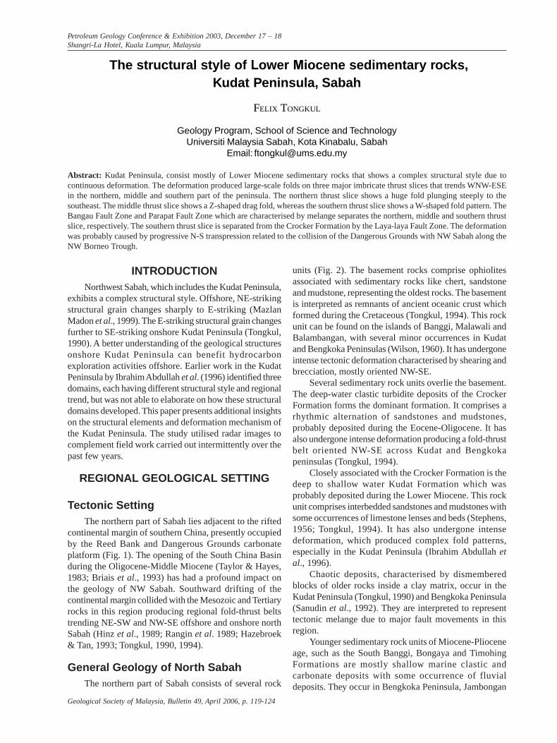
continental margin of southern China, presently occupiedby the Reed Bank and Dangerous Grounds carbonateplatform (Fig. 1). The opening of the South China Basinduring the Oligocene-Middle Miocene (Taylor & Hayes,1983; Briais et al., 1993) has had a profound impact onthe geology of NW Sabah. Southward drifting of thecontinental margin collided with the Mesozoic and Tertiaryrocks in this region producing regional fold-thrust beltstrending NE-SW and NW-SE offshore and onshore northSabah (Hinz et al., 1989; Rangin et al. 1989; Hazebroek& Tan, 1993; Tongkul, 1990, 1994).
General Geology of North SabahThe northern part of Sabah consists of several rock
units (Fig. 2). The basement rocks comprise ophiolitesassociated with sedimentary rocks like chert, sandstoneand mudstone, representing the oldest rocks. The basementis interpreted as remnants of ancient oceanic crust whichformed during the Cretaceous (Tongkul, 1994). This rockunit can be found on the islands of Banggi, Malawali andBalambangan, with several minor occurrences in Kudatand Bengkoka Peninsulas (Wilson, 1960). It has undergoneintense tectonic deformation characterised by shearing andbrecciation, mostly oriented NW-SE.
Several sedimentary rock units overlie the basement.The deep-water clastic turbidite deposits of the CrockerFormation forms the dominant formation. It comprises arhythmic alternation of sandstones and mudstones,probably deposited during the Eocene-Oligocene. It hasalso undergone intense deformation producing a fold-thrustbelt oriented NW-SE across Kudat and Bengkokapeninsulas (Tongkul, 1994).
Closely associated with the Crocker Formation is thedeep to shallow water Kudat Formation which wasprobably deposited during the Lower Miocene. This rockunit comprises interbedded sandstones and mudstones withsome occurrences of limestone lenses and beds (Stephens,1956; Tongkul, 1994). It has also undergone intensedeformation, which produced complex fold patterns,especially in the Kudat Peninsula (Ibrahim Abdullah etal., 1996).
Chaotic deposits, characterised by dismemberedblocks of older rocks inside a clay matrix, occur in theKudat Peninsula (Tongkul, 1990) and Bengkoka Peninsula(Sanudin et al., 1992). They are interpreted to representtectonic melange due to major fault movements in thisregion.
Younger sedimentary rock units of Miocene-Plioceneage, such as the South Banggi, Bongaya and TimohingFormations are mostly shallow marine clastic andcarbonate deposits with some occurrence of fluvialdeposits. They occur in Bengkoka Peninsula, Jambongan
THE STRUCTURAL STYLE OF LOWER MIOCENE SEDIMENTARY ROCKS, KUDAT PENINSULA, SABAH
Geological Society of Malaysia, Bulletin 49120
Island, Banggi Island and Balambangan Island (Stephens,1956; Wilson, 1960; Tongkul, 1990, 1991). These rockunits have undergone mild tectonic deformation producingopen fold structures.
Lithostratigraphy of Kudat PeninsulaThe stratigraphy of the Kudat Peninsula is still not
clearly understood. Based on available data, the area maybe divided into two major sedimentary rock units – theKudat Formation occupying most of the peninsula and theCrocker Formation occupying the southern part of thepeninsula (Fig. 3). The relationship between the twoformations is still uncertain – the division adopted here isbased on scarce paleontological evidence obtained byStephens (1956) and on their structural style. The CrockerFormation is interpreted to be of Eocene to Early Mioceneage, whereas the Kudat Formation of Lower Miocene age.The Crocker Formation shows characteristics of deep-waterdepositional environment, whereas the Kudat Formationshows both characteristics of deep-water and shallow-waterdepositional environments. It is possible that the KudatFormation was deposited in a shelf-slope environment.Both formations presumably lie on top of the basementrock comprising of Cretaceous-Paleocene ophioliticsequence.
Figure 1. Tectonic setting of Northern Sabah. The riftedcontinental margin of China impinging on NW Borneo-Palawanregion. Based on Rangin (1989), Hinz et al. (1991), Hamilton(1979), Taylor and Hayes (1983) and Briais et al. (1993).
The Kudat Formation has initially been subdividedinto several members (Garau, Tajau, Sikuati, Gomantong,Dudar, Sirar) by Liechti et al. (1960). This has not beenfollowed here due to the confusing nature of thesubdivisions. Instead, the Kudat Formation is divided intothere major informal unit, a Lower, Middle and Upper,referring to significant changes in the composition of thesediments (see Fig. 3). The Lower Unit comprises mostlysandstone and mudstone, where sandy beds predominate(Fig. 4). It outcrops at the northen tip of Kudat peninsula,coinciding with the Tajau Member of Liechti et al. (1960).The Middle Unit comprises sandstone and mudstone withsome occurrences of limestone beds and lenses. Here,mudstones appear to predominate occupying the middlepart of the Kudat Peninsula (Figs. 5 & 6). The sequencehas been referred to previously as the Sikuati Member.The Upper Unit comprises sandstone and mudstone ofvarious proportions and occupies the southern part of thepeninsula and was referred to previously as the GomantongMember (Fig. 7).
A chaotic deposit showing a linear distribution occurswithin the Kudat Formation. It comprises variouslithologies in a mixed grey and red mud matrix. It isreferred to informally here as a melange deposit,interpreted to have formed sometime after the depositionof the Kudat Formation.
STRUCTURAL ELEMENTSThe Kudat Peninsula shows elongate strike ridges
trending in various directions (see Fig. 3). The diverseorientation of strike ridges is due to the presence of large-scale folds and faults. The sedimentary sequences in thearea generally dip steeply and in places are closely foldedand faulted.
FoldsSeveral large-scale folds occur across the peninsula.
A huge fold plunging steeply to the ESE occurs at thenorthern part of Kudat and affects the Lower and MiddleUnit of the Kudat Formation. A Z-shaped drag fold withits axis trending approximately NW-SE affects the MiddleUnit of the Kudat Formation near Sikuati (Fig. 8). A W-shaped fold pattern occurs at the southern part of thepeninsula and affects the Upper Unit of the KudatFormation. Within the large-scale folds several outcrop-scale folds occur (Fig. 9,10 & 11). The medium and small-scale folds shows steep plunge and resemble drag folds.
FaultsSeveral large-scale strike-slip faults trend
approximately NW-SE cutting through the strike ridges(see Fig. 3). The most notable strike-slip fault, referred toas the Bangau Fault Zone, extends from Tg. Bangau toKudat Town. Along its path blocks of the Kudat Formationtogether with older basement rock units are embedded in

FELIX TONGKUL
April 2006 121
Figure 2. Regional geology of Northern Sabah. Based on Mazlanet al., (1999), Tongkul (1994) and Stephens (1956).
Figure 3. Geological map of Kudat Peninsula showing thedistribution of the Lower, Middle and Upper Units of the KudatFormation. The structural cross-section illustrates the style offolding and the location of three major fault zones.
Figure 4. Steeply dipping sandstone with thin mudstone interbedsnear Suangpai, typical of the sandy Lower Unit of the KudatFormation.
Figure 5. Vertically dipping grey mudstone with thin sandstoneinterbeds near Sikuati Town typical of the muddy Middle Unitof the Kudat Formation.
Figure 6. Steeply dipping limestone beds near Dampirit occurwithin the Middle Unit of the Kudat Formation.
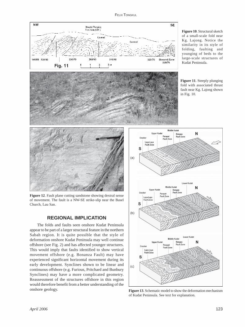
a sheared mud matrix, mapped as a melange deposit. Thefault shows a dextral sense of movement based on faultplane markings (Fig. 12). Further south another NW-SEtrending strike-slip fault, referred to as the Parapat FaultZone extends from Tg. Terongkongan to Tg. Parapatseparating the Z-shaped and W-shaped fold pattern. Blocksof the Kudat sediments inside a sheared mud matrix occurnear Kg. Parapat Darat. A NE-SW trending fault, referredto as the Laya-laya Fault Zone separates the KudatFormation from the Crocker Formation. Along this faultzone, deformed and sheared layers of the Crockersediments occur. Within the three major fault zones several

THE STRUCTURAL STYLE OF LOWER MIOCENE SEDIMENTARY ROCKS, KUDAT PENINSULA, SABAH
Geological Society of Malaysia, Bulletin 49122
outcrop-scale thrust faults occur, usually associated withabrupt change in bedding orientations. Small-scale thrustfaults associated with drag folds are common (see Fig.10).
STRUCTURAL EVOLUTION
Deformation MechanismThe occurrence of steeply plunging folds and refolded
folds clearly indicates that Kudat Peninsula experiencedpolyphase deformation. The presence of Z-shaped dragfolds suggests transpressional tectonics may have beeninvolved.
It is envisaged that early N-S directed deformationproduced several E-W trending thrust-fold slices on the
Kudat sediments and underlying ophiolitic basement. Eachslice was between 8-10 km wide and separated bydetachment or slip zones. Within each thrust slice, minorfolds (F1) and thrust faults developed causing repetitionof the Kudat sediments (Fig. 13a).
Later NW-SE directed deformation producedhorizontal movement along each of the major detachmentzones causing second generation drag folds (F2) to developwithin each thrust slice (Fig 13b). The different types offolds within individual thrust slices was possibly relatedto the competency of the Kudat sedimentary sequence.The occurrence of more competent sandy beds in theLower Kudat Unit produced a steep plunging fold structure.The development of the huge fold was possiblyaccompanied by intense shearing along the detachmentzone, producing the melange deposit here. In the moremuddy Middle and Upper Kudat Units a contorted Z andW-shaped fold pattern developed (Fig. 13c).
Origin of DeformationIt is envisaged that the N-S directed transpressional
deformation, originated from the collision of theDangerous Grounds and Reed Bank with NW Sabah alongthe NW Borneo Trough during the Middle Miocene (seeFig. 1). As the continental margin of southern Chinaprogressively impinged upon northern Sabah an E-Wtrending fold-thrust belt developed earlier was furthershortened and bent south-eastward with a significantdextral strike-slip component (Fig. 14).
Figure 8. Structural sketch map of Sikuati area showing large-scale and medium-scale Z-shaped folds.
Figure 9. Steeply plunging Z-shaped fold cut through by NW-SE trending faults near Sikuati Secondary School.
Figure 7. Overturned sandstone beds showing sole markings nearIndarasan Laut occur within the Upper Unit of the KudatFormation. Notice the conjugate sets of fractures on the sandstonesurface.
FELIX TONGKUL
April 2006 123
Figure 10. Structural sketchof a small-scale fold nearKg. Lajong. Notice thesimilarity in its style offolding, faulting andyounging of beds to thelarge-scale structures ofKudat Peninsula.
Figure 11. Steeply plungingfold with associated thrustfault near Kg. Lajong shownin Fig. 10.
Figure 12. Fault plane cutting sandstone showing dextral senseof movement. The fault is a NW-SE strike-slip near the BaselChurch, Lau San.
Figure 13. Schematic model to show the deformation mechanismof Kudat Peninsula. See text for explanation.
REGIONAL IMPLICATIONThe folds and faults seen onshore Kudat Peninsula
appear to be part of a larger structural feature in the northernSabah region. It is quite possible that the style ofdeformation onshore Kudat Peninsula may well continueoffshore (see Fig. 2) and has affected younger structures.This would imply that faults identified to show verticalmovement offshore (e.g. Bonanza Fault) may haveexperienced significant horizontal movement during itsearly development. Synclines shown to be linear andcontinuous offshore (e.g. Furious, Pritchard and BunburySynclines) may have a more complicated geometry.Reassessment of the structures offshore in this regionwould therefore benefit from a better understanding of theonshore geology.

THE STRUCTURAL STYLE OF LOWER MIOCENE SEDIMENTARY ROCKS, KUDAT PENINSULA, SABAH
Geological Society of Malaysia, Bulletin 49124
western continental margin of Sabah/Borneo.Geologisches Rundschau 78, 705-730.
HAZEBROEK, H.P. & TAN, D.N.K., 1993. Tertiary tectonicevolution of the NW Sabah continental margin. Bull.Geol. Soc. Malaysia 33, 195-210.
IBRAHIM ABDULLAH, DEWARMAN & BASIR JASIN, 1996.Deformational style of the Kudat Formation, KudatPeninsula, Sabah. Warta Geologi 22(3), 235.
LIECHTI, P., ROE, F.W. & HAILE, N.S., 1960. The geologyof Sarawak, Brunei and western part of North Borneo.British Borneo Geol. Surv. Bull. 3.
MAZLAN MADON, LEONG, K.M. & AZLINA ANUAR, 1999.Sabah Basin. The Petroleum Geology and Resourcesof Malaysia, PETRONAS, 501-538.
RANGIN, C., 1989. The Sulu Sea, a marginal setting with acollision zone. Tectonophysics 183, 305-319.
RANGIN, C., BELLON, H., BERNARD, F., LETOUZEY, J., MULLER,C. & SANUDIN, T., 1990. Neogene arc-continentcollision in Sabah, northern Borneo (Malaysia).Tectonophysics 183, 305-319.
SANUDIN, H.T., MUHAMMAD, B.G., PEREIRA, J.J. & QUEK,C.J., 1992. Occurrence of mélange in the BengkokaPeninsula, Sabah. Warta Geologi 18(1), 1-7.
STEPHENS, E.A., 1956. The geology and mineral resourcesof the Kota Belud and Kudat Area, North Borneo.British Borneo Geol. Surv. Mem. 5.
TAYLOR, B. & HAYES, D.E., 1983. Origin and history of theSouth China Sea Basin. Tectonic and geologicevolution of Southeast Asian seas and islands, Part 2.American Geophysical Union Monograph 27, 23-56.
TONGKUL, F., 1990. Structural styles and tectonics ofwestern and northern Sabah. Bull. Geol. Soc. Malaysia27, 227-239.
TONGKUL, F., 1991. Basin development and deposition ofthe Bongaya Formation in the Pitas Area, NorthernSabah. Bull. Geol. Soc. Malaysia 29, 183-193.
TONGKUL, F., 1994. The geology of northern Sabah,Malaysia: its relationship to the opening of the SouthChina Sea Basin. Tectonophysics 235, 131-137.
WILSON, R.A.M., 1960. The geology and mineral resourcesof the Banggi Island and Sugut River area, NorthBorneo. British Borneo Geol. Surv. Mem. 15.
Figure 14. Schematic tectonic model to show how the Paleogene-Neogene fold-thrust belts evolved in North Sabah.
ACKNOWLEDGEMENTSI would like to thank Universiti Malaysia Sabah for
supporting this research. I wish to thank Watin Malun andMarcus Jopony for their companionship in the field; forthe Geological Survey of Malaysia in Kota Kinabalu fortheir continued support and access to secondaryinformation; and for PETRONAS for granting me accessto their SAR imagery data. My special thanks to CharlesHutchison and two anonymous reviewers whose criticalcomments helped improved the manuscript.
REFERENCESBRIAIS, A., PATRIAT, P. & TAPPONNIER, P., 1993. Updated
interpretation of magnetic anomalies and seafloorspreading stages in the South China Sea. Implicationsfor the Tertiary tectonics of southeast Asia. Journ.Geophys. Res. 98(B4), 6299-6328.
HAMILTON, W., 1979. Tectonics of the Indonesian region.U.S. Geol. Surv. Prof. Paper 1078.
HINZ, K., FRITSCH, J., KEMPTER, E.H.K., MOHAMMAD, A.M.,MEYER, J., MOHAMED, D., VOSBERG, H., WEBER, J. &BENAVIDEZ, J., 1989. Thrust tectonics along the north-
Manuscipt received 6 August 2004Revised manuscript received 31 March 2005