fuzzy delphi for marine space stakeholder...
TRANSCRIPT
Proceedings of the World Cadastre Summit 2015, Istanbul
342 | P a g e
FUZZY DELPHI FOR MARINE SPACE STAKEHOLDER FRAMEWORK DEVELOPMENT: AN ANALYTICAL
LITERATURE REVIEW
Nazirah Mohamad Abdullah1, Abdullah Hisam Omar2, Shuib Rambat3, Rodzah Yahya4, Siti Zainon Mohamad5, Tuan Mohammad Tuan Yacob6, Wan Muhammad Aizat Wan Azhar7, Mohd Farid Al Azmi Isahak8, Mohd
Naszrie Razali9
123 Department of Geoinformation, Faculty of Geoinformation & Real Estate, UTM Skudai, 81310, Johor, Malaysia
[email protected]; [email protected]; [email protected] 4Department of Electrical Engineering, Politeknik Merlimau, PO Box 1031, Pejabat Pos
Merlimau, 77300 Merlimau, Melaka, Malaysia - [email protected] 56789 Department of Geoinformation, Faculty of Geoinformation & Real Estate, UTM Skudai,
81310, Johor, Malaysia ABSTRACT This paper presents an analytical literature review on Fuzzy Delphi Method (FDM) and Marine Space Stakeholder Issues (MSSI) of papers published between 2000 and 2013. In this review were divided into two leading groups. The main group comprise of publications which proposed some models/method to develop Marine Space Stakeholder Framework. Then the followed by Fuzzy Delphi Method used in Stakeholder Framework. Finally, all the publications were analyzed using comparable method in order to distinguish the research gaps and their future directions. This study found that FDM has a great potential to be applied in Marine Space Stakeholder Issues (MSSI) for developing the Marine Space Stakeholder Framework. This approach is emphasized on the importance of Marine Space Stakeholder framework goals on each of the strategy capabilities to satisfy with the fuzzy numbers. It takes into considerations on both goals known as tangible and intangible goals which dealing with the selection problem. Thus, the adequate ability of nature opinions of the marine space stakeholders can be measured and accessed, indeed an appropriate framework will be useful for the stakeholder’s guidance. Key words: Fuzzy Delphi Method, Stakeholder, Marine Space Stakeholder Issues INTRODUCTION The responsibility of marine area management and administrations particularly to facilitate the stakeholder effective engagement in economic perspective, social and environmental, needs participation from the rest of the world. The responsibility includes; the marine space administrations, marine governing property rights, and the use of marine and maritime. However, those activities are usually governed by various aspects which regard to the roles and responsibilities of each stakeholder as the stakeholder engagement gives a significant impact as it able to affect the success of sustainable marine space environment (Liu, Ballinger, Jaleel,
http://wcadastre.org
343 | P a g e
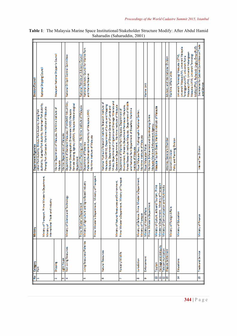
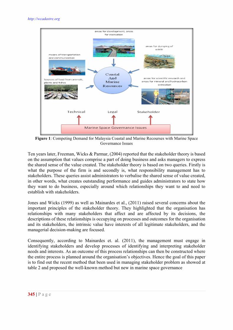
Wu, & Lin, 2012). In the early discussions on the analyses of Marine Space administrations emerged during 2004s which posed the three major issues, namely; technical, legal and stakeholders (Assessment et al., 2010; Binns, Rajabifard, Collier, & Williamson, 2003; Choon & Seng, 2013; Elisa, Michael, Tarrant, 2014; Maguire, Potts, & Fletcher, 2012; Ng’ang'a, Sutherland, Cockburn, & Nichols, 2004). The technical issue such as vertical datum, the high water mark as a jurisdictional limit and loose and overlapping jurisdictions amongst various government agencies merely able to be resolved by implementing new technology such as GPS, satellite imagery and geographic information system which greatly improved access to data collection while the legislation problem can be improved by introducing new policy instruments to the marine space area. However, the implementation and the improvement of the technical and legislation issues involve the stakeholder and an authorize individual who have interest on the marine spaces which includes various sections of the government agencies. The relationship between all stakeholders together with the technical and legislation implementation could achieve many economic goals, social, politic, and environment blocked (Nichols, S., Monahan, D., & Sutherland, 2000). There are various techniques have been used to resolve the stakeholder issue and yet the solution is usually applicable to that particular study area. Thus, this literature study is aimed to identify an identical case of study with regard to the use of FDM in solving the stakeholder issue of the marine space area. STAKEHOLDER Stakeholder can be defined as A person with an interest or concern in something, especially a business (Oxford Dictionary, 2014). However, in broad terms, stakeholder can be defined as an individual or a group of people that have common characteristic of interest, who looking forward for the system or organization success. In marine spaces, the stakeholder can be divided into three categories; known as national, state and local organizations in sustainable with various department and agencies which including government, private and education organizations (Tarmidi et al., 2014) and each of the category that has jurisdiction in the marine environment is able to create their own marine manage areas or spaces. Marine manage areas, in the widest sense, are geographic areas that been designed to protect or manage resources within the marine environment. In Malaysia, the creating agency could be a federal, state, territorial, tribal, or local government and an independent agency, or a regional entity with resource authority, such as a port management council. Table 1 shows some samples of the Malaysia Marine Space stakeholder with 15 categories of marine space activities, 14 ministries and more than 30 departments/units are responsible for the management of the marine space activities. What interesting in this data that there is visible from multiple stakeholders under various ministries? Therefore, clarity is needed in the stakeholder administrative management of the marine environment. In Malaysia, there are various stakeholders and activities in the marine environment such as in land development, coastal activities, agriculture, tourism related activities, native title or indigenous issues, marine parks or protected area, aquaculture, oil and gas exploration, shipping the international boat or local, waste management from industry, cable and pipelines for the water supply or electricity and heritage area such as shipwreck. There are many different activities occurring the ocean surface as shown in Figure 1.
Proceedings of the World Cadastre Summit 2015, Istanbul
344 | P a g e
Table 1: The Malaysia Marine Space Institutional/Stakeholder Structure Modify: After Abdul Hamid Saharudin (Saharuddin, 2001)
http://wcadastre.org
345 | P a g e
Figure 1: Competing Demand for Malaysia Coastal and Marine Recourses with Marine Space
Governance Issues Ten years later, Freeman, Wicks & Parmar, (2004) reported that the stakeholder theory is based on the assumption that values comprise a part of doing business and asks managers to express the shared sense of the value created. The stakeholder theory is based on two queries. Firstly is what the purpose of the firm is and secondly is, what responsibility management has to stakeholders. These queries assist administrators to verbalise the shared sense of value created, in other words, what creates outstanding performance and guides administrators to state how they want to do business, especially around which relationships they want to and need to establish with stakeholders. Jones and Wicks (1999) as well as Mainardes et al., (2011) raised several concerns about the important principles of the stakeholder theory. They highlighted that the organisation has relationships with many stakeholders that affect and are affected by its decisions, the descriptions of these relationships is occupying on processes and outcomes for the organisation and its stakeholders, the intrinsic value have interests of all legitimate stakeholders, and the managerial decision-making are focused. Consequently, according to Mainardes et. al. (2011), the management must engage in identifying stakeholders and develop processes of identifying and interpreting stakeholder needs and interests. As an outcome of this process relationships can then be constructed where the entire process is planned around the organisation’s objectives. Hence the goal of this paper is to find out the recent method that been used in managing stakeholder problem as showed at table 2 and proposed the well-known method but new in marine space governance
Proceedings of the World Cadastre Summit 2015, Istanbul
346 | P a g e
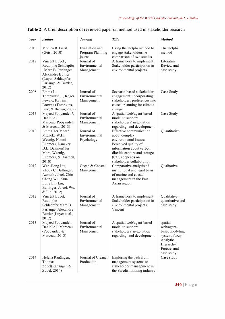
Table 2: A brief description of reviewed paper on method used in stakeholder research
Year Author Journal Title Method
2010 Monica R. Geist (Geist, 2010)
Evaluation and Program Planning journal
Using the Delphi method to engage stakeholders: A comparison of two studies
The Delphi method
2012 Vincent Luyet , Rodolphe Schlaepfer , Marc B. Parlangea, Alexandre Buttler (Luyet, Schlaepfer, Parlange, & Buttler, 2012)
Journal of Environmental Management
A framework to implement Stakeholder participation in environmental projects
Literature Review and case study
2008 Emma L. Tompkinsa,,1, Roger Fewa,c, Katrina Browna (Tompkins, Few, & Brown, 2008)
Journal of Environmental Management
Scenario-based stakeholder engagement: Incorporating stakeholders preferences into coastal planning for climate change
Case Study
2013 Majeed Pooyandeh*, Danielle J. Marceau(Pooyandeh & Marceau, 2013)
Journal of Environmental Management
A spatial web/agent-based model to support stakeholders’ negotiation regarding land development
Case Study
2010 Emma Ter Mors*, Mieneke W.H. Weenig, Naomi Ellemers, Dancker D.L. Daamen(Ter Mors, Weenig, Ellemers, & Daamen, 2010)
Journal of Environmental Psychology
Effective communication about complex environmental issues: Perceived quality of information about carbon dioxide capture and storage (CCS) depends on stakeholder collaboration
Quantitative
2012 Wen-Hong Liu, Rhoda C. Ballinger, Azmath Jaleel, Chin-Cheng Wu, Kun-Lung Lin(Liu, Ballinger, Jaleel, Wu, & Lin, 2012)
Ocean & Coastal Management
Comparative analysis of institutional and legal basis of marine and coastal management in the East Asian region
Qualitative
2012 Vincent Luyet, Rodolphe Schlaepfer,Marc B. Parlange, Alexandre Buttler (Luyet et al., 2012)
Journal of Environmental Management
A framework to implement Stakeholder participation in environmental projects Vincent
Qualitative, quantitative and case study
2013 Majeed Pooyandeh, Danielle J. Marceau (Pooyandeh & Marceau, 2013)
Journal of Environmental Management
A spatial web/agent-based model to support stakeholders’ negotiation regarding land development
spatial web/agent-based modeling system, fuzzy Analytic Hierarchy Process and case study
2014 Helena Ranängen, Thomas Zobel(Ranängen & Zobel, 2014)
Journal of Cleaner Production
Exploring the path from management systems to stakeholder management in the Swedish mining industry
Case study
http://wcadastre.org
347 | P a g e
2010 Emma Ter Mors*, Mieneke W.H. Weenig, Naomi Ellemers, Dancker D.L. Daamen Leiden(Ter Mors et al., 2010)
Journal of Environmental Psychology
Effective communication about complex environmental issues: Perceived quality of information about carbon dioxide capture and storage (CCS) depends on stakeholder collaboration
Quantitative
2014 V.M.Waligo ,J. Clarke and R. Hawkins (V.M. Waligo, Clarke, & Hawkins, 2014)
Journal of Business Research
The ‘Leadership–Stakeholder Involvement Capacity’ nexus in stakeholder management
Case study
2013 Victoria M. Waligoa,, Jackie Clarke, Rebecca Hawkins(Victoria M. Waligo, Clarke, & Hawkins, 2013)
Tourism Management
Implementing sustainable tourism: A multi-stakeholder involvement management framework
Case study
2014 Xuan-Quynh Le , Van-Hieu Vub, Luc Hensc, Bas Van Heur (Le, Vu, Hens, & Van Heur, 2014)
Journal of Cleaner Production
Stakeholder perceptions and involvement in the implementation of EMS in ports in Vietnam and Cambodia
Qualitative and Quantitative
2014 Stephanie Missonier, and Sabrina Loufrani-Fedida (Missonier & Loufrani-Fedida, 2014)
International Journal of Project Management
Stakeholder analysis and engagement in projects: From stakeholder relational perspective to stakeholder relational ontology
Qualitative longitudinal study
2012 Heidi M. Nutters and Patricia Pinto da Silva (Nutters & Pinto da Silva, 2012a)
Ocean & Coastal Management
Fishery stakeholder engagement and marine spatial planning: Lessons from the Rhode Island Ocean SAMP and the Massachusetts Ocean Management Plan
Qualitative
2014 Judith van Leeuwen, Jesper Raakjaer, Luc van Hoof, Jan van Tatenhove , Ronán Long and Kristen Ounanian (van Leeuwen et al., 2014)
Marine Policy Implementing the Marine Strategy Framework Directive: A policy perspective on regulatory, institutional and stakeholder impediments to effective implementation
Qualitative
It is apparent from this table that most researchers used qualitative and quantitative methods in their studies then, followed by case study methodology. Literature review studies seen by the authors of the study were randomly selected research papers in stakeholders issues where it started from 2010 to 2014 in 10 refereed journals. However, there are also studies that seen by the authors of marine space stakeholders. Their study has chosen qualitative method (Liu et al., 2012; Nutters & Pinto da Silva, 2012b; van Leeuwen et al., 2014).
Proceedings of the World Cadastre Summit 2015, Istanbul
348 | P a g e
In recent years there has been growing awareness of the importance of stakeholder relationship analysis related to the marine space governance focusing the need for a structured and consistent approach to the definition, maintenance and management of the marine space administrations. Several authors (Akter & Simonovic, 2005; Gray et al., 2014; Ishikawa et al., 1993; Pooyandeh & Marceau, 2013; van Vliet, Kok, & Veldkamp, 2010) have already proclaimed the potential value of the Fuzzy Delphi method to analyze stakeholder in a future setting. The authors argued that in uncertain environments it is necessary to analysed how stakeholder can impact marine space governance. The Fuzzy Delphi technique are summarized using FDMs, such as avoiding the distortion of expert opinions, clearly expressing the semantic structure of selected options, and the consideration of fuzzy nature during the survey process (Chang, Hsu, & Chang, 2011; Mohd Ridhuan Mohd Jamil, Saedah Siraj, Zaharah Hussin, Nurulrabihah Mat Noh, 2014). There-by, this method overcomes drawbacks of traditional group discussions, such as the stakeholder identification issues, stakeholder engagement and managing stakeholder data (Binns et al., 2003; Hoefnagel, de Vos, & Buisman, 2013; Plasman, 2008; Suzanne Bass et al., 2006),and produces answers quicker and more accurately than individual on the average (Ishikawa, Akira, 1993; Ma, Shao, Ma, & Ye, 2011; Mohd Ridhuan Mohd Jamil, Saedah Siraj, Zaharah Hussin, Nurulrabihah Mat Noh, 2014). Therefore this paper tries to see the current practise/model of using Fuzzy Delphi Method Therefore; this paper tries to look at the current practice / model of using FDM for obtaining consensus from experts in a particular issue and to prove this method is also suitable for developing framework for marine space stakeholder management. MARINE SPACE STAKEHOLDER ISSUES (MSSI) The successful application of Marine Space Governance to resolve conflicts in coastal regions depends on the level of stakeholder involvement, data availability and the existing knowledge. Practical problems in governance namely; first how identify who the stakeholders are; second; how to engage them effectively; and third how to manage their input, including keeping the dialogue going over time (M. Sutherland & Nichols, 2006). Author list three possibilities category marine space stakeholders, namely local, regional, and national level. The stakeholder thinking into multiple disciplines, stakeholders are predominantly defined solely by their generic economic function—to consume, invest, supply, and so on (Crane & Ruebottom, 2012). The central idea of this research is that current stakeholder involvement approaches for large-scale marine space governance are inadequate, and that effective stakeholder involvement in the representation, design and management of complex administration systems an essential part of marine space governance decision-making. The emphasis on “effective” refers to the fact that not all stakeholder involvement results in improved decision-making. Why is there so much resistance and hesitation when it comes to stakeholder involvement, if its intrinsic merits are broadly accepted? One possible answer is that many of the current approach to stakeholder involvement is inadequate and either fails at producing agreements, or fail at creating consensus between stakeholder. In recent years, there has been an increasing amount of literature on issues in marine space administration and marine space governance. More recent studies have confirmed that practical
http://wcadastre.org
349 | P a g e
problems in marine space governance include such as how identify who the stakeholders are, how to engage them effectively and how to manage stakeholder input, including keeping the dialogue going over time (Hillman, 2010; Luyet et al., 2012; Matos & Silvestre, 2013; Sutherland & Nichols, 2006). M. Sutherland & Nichols (2006) summarized this as defining the governance process in terms of liaising, listening, learning, and leading. More importantly to consider is too often agencies responsible for programs and projects focus only on the last step. One of the greatest limitations in most marine programs and projects is having a narrow approach to stakeholder participation. This is often driven by issues such as: time constraints, lack of knowledge, single issue focus, or governmental silos. It is particularly true in coastal region were there may be jurisdictional uncertainty, overlaps, and gaps (Boateng, 2006; Elisa, Michael, Tarrant, 2014; Sutherland & Nichols, 2006). Despite it importance, the identification of stakeholders, including the identification of their needs and expectations, is poorly achieved in marine space stakeholder management projects. There is essential for establishing effective relationships and collaboration between them after identification of stakeholder. Again, effective relationship is not just “this is what we are going to do for you” (Ng’ang'a et al., 2004; M. Sutherland & Nichols, 2006). Once input is obtained, consensus building strategies are required to establish priorities and identify appropriate solutions here called as managing stakeholder input based on the priority. Normally the priorities are different at the local, regional, and national level. There are many marine space stakeholders and a main function of governance is to improve the communication and collaboration among them. Most of the literature on the marine space issues focused mainly on the technical issues. In addition to these, systematic studies on the marine space stakeholder issues are still needed for better understanding of marine space governance. There is a need to create a framework for marine space stakeholder management in order to provide a foundation from which governance issues, including the global focus on sustainable development, can be addressed. In order to address this, marine space stakeholder management framework was carried out by Author. Therefore Author goes to detailed information related current practice or models were used in stakeholder research and it will be elaborated in the next topic. LITERATURE REVIEW ON CURRENT PRACTICE/MODEL Fuzzy Delphi Method introduced by Murray, Pipino and Gigch in 1985 and reviewed by Kaufman and Gupta by 1988 (Ahmad, Muhidin, Wasli, Salihin, & Mohd, 2014; Guru et al., 2014; Hsu, Lee, & Kreng, 2010; Ma, Shao, Ma, & Ye, 2011; Mohd Ridhuan Mohd Jamil, Saedah Siraj, Zaharah Hussin, Nurulrabihah Mat Noh, 2014; Mohd Ridzuan Mohd Jamil, Zaharah Hussin, Nurul Rabihah Mohd Noh, 2013). Fuzzy Delphi Method is a combination of fuzzy set numbering or fuzzy set theory with traditional Delphi Method (Lin, 2013) to overcome the weakness of the existing Delphi Method (Chang, Hsu, & Chang, 2011). Lotfi Zadeh in 1965 a great researcher and also recognized as an expert mathematician was introducing the fuzzy set numbering or fuzzy set theory Fuzzy. His serve as an extension of the classical set theory, where each element in a set is evaluated on the basis of a set of binary (‘yes” or “no”) responses. Fuzzy set theory also permits the gradual assessment of each element in a set, and the value contained in this fuzzy set is from 0 to 1 or in the unit interval (0,1).
Proceedings of the World Cadastre Summit 2015, Istanbul
350 | P a g e
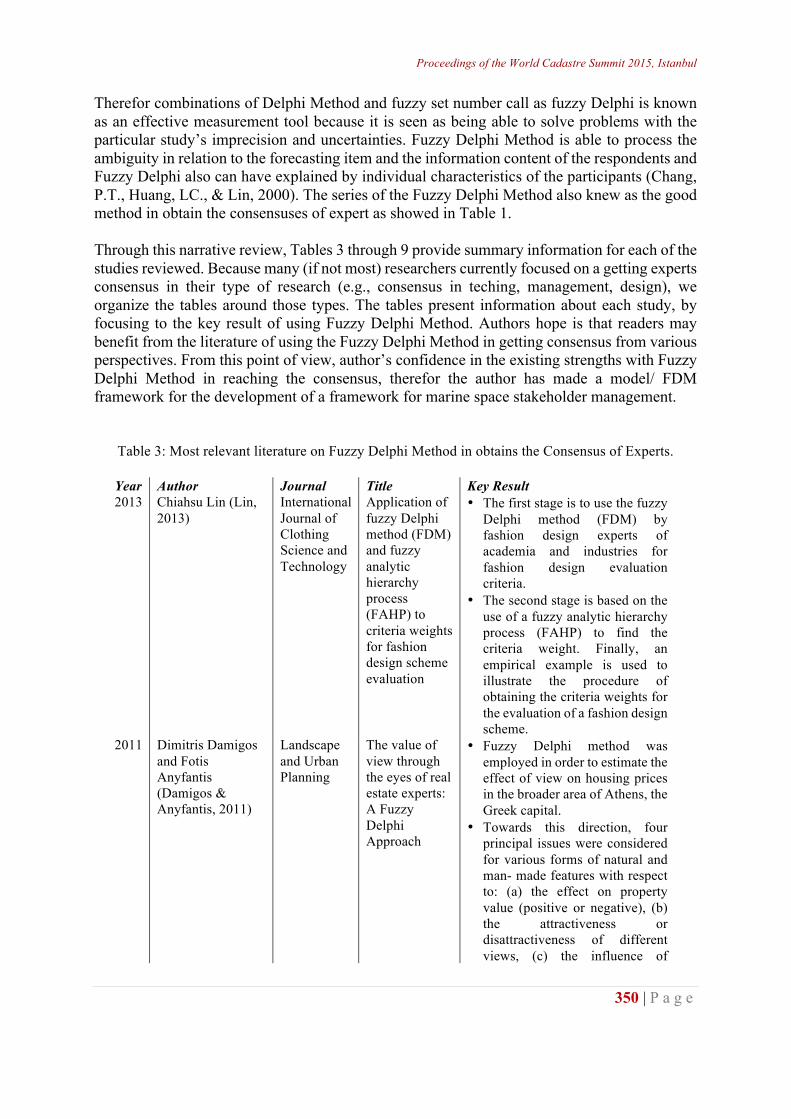
Therefor combinations of Delphi Method and fuzzy set number call as fuzzy Delphi is known as an effective measurement tool because it is seen as being able to solve problems with the particular study’s imprecision and uncertainties. Fuzzy Delphi Method is able to process the ambiguity in relation to the forecasting item and the information content of the respondents and Fuzzy Delphi also can have explained by individual characteristics of the participants (Chang, P.T., Huang, LC., & Lin, 2000). The series of the Fuzzy Delphi Method also knew as the good method in obtain the consensuses of expert as showed in Table 1. Through this narrative review, Tables 3 through 9 provide summary information for each of the studies reviewed. Because many (if not most) researchers currently focused on a getting experts consensus in their type of research (e.g., consensus in teching, management, design), we organize the tables around those types. The tables present information about each study, by focusing to the key result of using Fuzzy Delphi Method. Authors hope is that readers may benefit from the literature of using the Fuzzy Delphi Method in getting consensus from various perspectives. From this point of view, author’s confidence in the existing strengths with Fuzzy Delphi Method in reaching the consensus, therefor the author has made a model/ FDM framework for the development of a framework for marine space stakeholder management.
Table 3: Most relevant literature on Fuzzy Delphi Method in obtains the Consensus of Experts.
Year Author Journal Title Key Result 2013 Chiahsu Lin (Lin,
2013) International Journal of Clothing Science and Technology
Application of fuzzy Delphi method (FDM) and fuzzy analytic hierarchy process (FAHP) to criteria weights for fashion design scheme evaluation
• The first stage is to use the fuzzy Delphi method (FDM) by fashion design experts of academia and industries for fashion design evaluation criteria.
• The second stage is based on the use of a fuzzy analytic hierarchy process (FAHP) to find the criteria weight. Finally, an empirical example is used to illustrate the procedure of obtaining the criteria weights for the evaluation of a fashion design scheme.
2011 Dimitris Damigos and Fotis Anyfantis (Damigos & Anyfantis, 2011)
Landscape and Urban Planning
The value of view through the eyes of real estate experts: A Fuzzy Delphi Approach
• Fuzzy Delphi method was employed in order to estimate the effect of view on housing prices in the broader area of Athens, the Greek capital.
• Towards this direction, four principal issues were considered for various forms of natural and man- made features with respect to: (a) the effect on property value (positive or negative), (b) the attractiveness or disattractiveness of different views, (c) the influence of
http://wcadastre.org
351 | P a g e
distance and (d) the price alteration
2011 Pao-Long Changa, Chiung-Wen Hsub, Po-Chien Chang (Chang et al., 2011)
International Journal of Hydrogen
Fuzzy Delphi method for evaluating hydrogen production technologies
• The linguistic scores are then converted into fuzzy numbers, and a consensus of the decision makers’ opinions on weights and ratings is mathematically derived using fuzzy Delphi methodology.
2014 Farzad Tahriri, Maryam Mousavi Siamak Hozhabri Haghighi, Siti Zawiah Md Dawal (Tahriri, Mousavi, Hozhabri Haghighi, & Zawiah Md Dawal, 2014)
Journal of Industrial Engineering International
The application of fuzzy Delphi and fuzzy inference system in supplier ranking and selection
• Fuzzy Delphi method used to defining aspects and criteria for hierarchical structure.
• Fuzzy Delphi method to adjust the consensus condition
2014 Ying Wang a, Gi-Tae Yeo a,n, Adolf K.Y. Ng (Wang, Yeo, & Ng, 2014)
Transport Policy
Choosing optimal bunkering ports for liner shipping companies: A hybrid Fuzzy-Delphi–TOPSIS approach
• Fuzzy-Delphi–TOPSIS is a methodology combining the Fuzzy Delphi and Fuzzy TOPSIS methods for optimal decision making strategies.
• Fuzzy has four advantages: (1) to decrease the times of questionnaire surveys, (2) to avoid distorting individual expert opinions, (3) to clearly express the semantic structure of predicted items, and (4) to consider the fuzzy nature during the interview process
2012 Okan Durua, Emrah Bulut, and Shigeru Yoshida
Expert Systems with Applications
A fuzzy extended DELPHI method for adjustment of statistical time series prediction: An empirical study on dry bulk freight market case
• The Fuzzy Delphi based adjustment procedure is investigated in a dry bulk shipping example, and the results are promising.
• One critical conclusion is that the consensus of the group was ensured successfully since a reduction on variance is gained.
• Fuzzy Delphi based study provided superior predictions, as compared with the statistical benchmark results. In fact, statistical approach could not success over no-change strategy, but proposed method improved its accuracy by expert aided design.
2010 Yu-Lung Hsua, Cheng-Haw Lee a, and V.B. Kreng (Hsu et al., 2010)
Expert Systems with Applications
The application of Fuzzy Delphi Method and
• Fuzzy Delphi Method used to establish a hierarchical framework by reached a general consensus among experts.
Proceedings of the World Cadastre Summit 2015, Istanbul
352 | P a g e
Fuzzy AHP in lubricant regenerative technology selection
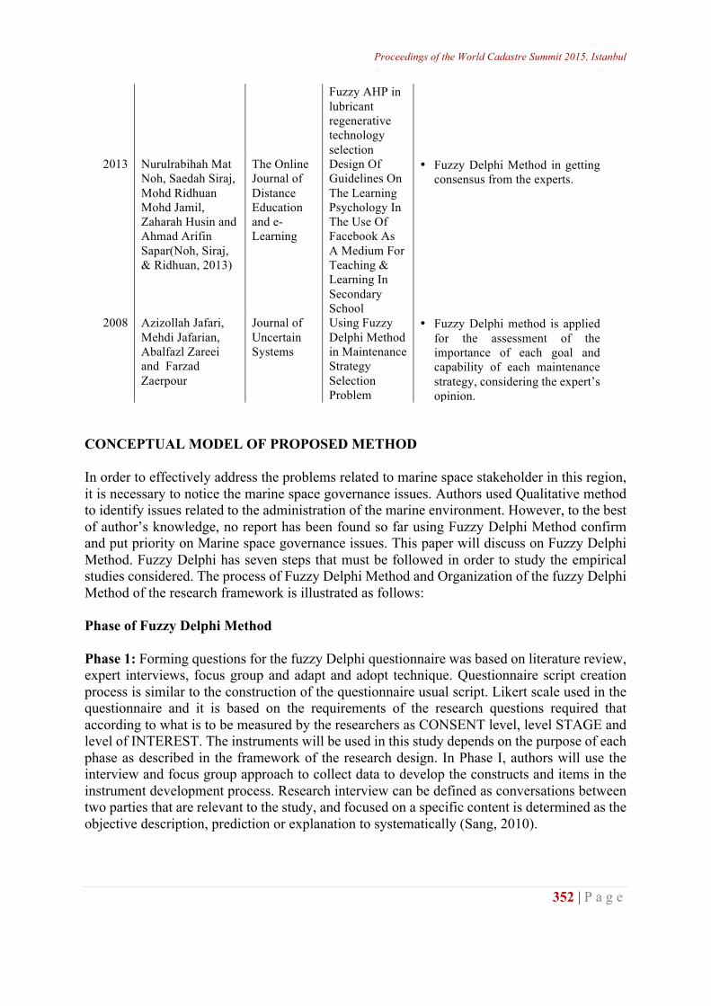
2013 Nurulrabihah Mat Noh, Saedah Siraj, Mohd Ridhuan Mohd Jamil, Zaharah Husin and Ahmad Arifin Sapar(Noh, Siraj, & Ridhuan, 2013)
The Online Journal of Distance Education and e-Learning
Design Of Guidelines On The Learning Psychology In The Use Of Facebook As A Medium For Teaching & Learning In Secondary School
• Fuzzy Delphi Method in getting consensus from the experts.
2008 Azizollah Jafari, Mehdi Jafarian, Abalfazl Zareei and Farzad Zaerpour
Journal of Uncertain Systems
Using Fuzzy Delphi Method in Maintenance Strategy Selection Problem
• Fuzzy Delphi method is applied for the assessment of the importance of each goal and capability of each maintenance strategy, considering the expert’s opinion.
CONCEPTUAL MODEL OF PROPOSED METHOD In order to effectively address the problems related to marine space stakeholder in this region, it is necessary to notice the marine space governance issues. Authors used Qualitative method to identify issues related to the administration of the marine environment. However, to the best of author’s knowledge, no report has been found so far using Fuzzy Delphi Method confirm and put priority on Marine space governance issues. This paper will discuss on Fuzzy Delphi Method. Fuzzy Delphi has seven steps that must be followed in order to study the empirical studies considered. The process of Fuzzy Delphi Method and Organization of the fuzzy Delphi Method of the research framework is illustrated as follows: Phase of Fuzzy Delphi Method Phase 1: Forming questions for the fuzzy Delphi questionnaire was based on literature review, expert interviews, focus group and adapt and adopt technique. Questionnaire script creation process is similar to the construction of the questionnaire usual script. Likert scale used in the questionnaire and it is based on the requirements of the research questions required that according to what is to be measured by the researchers as CONSENT level, level STAGE and level of INTEREST. The instruments will be used in this study depends on the purpose of each phase as described in the framework of the research design. In Phase I, authors will use the interview and focus group approach to collect data to develop the constructs and items in the instrument development process. Research interview can be defined as conversations between two parties that are relevant to the study, and focused on a specific content is determined as the objective description, prediction or explanation to systematically (Sang, 2010).
http://wcadastre.org
353 | P a g e
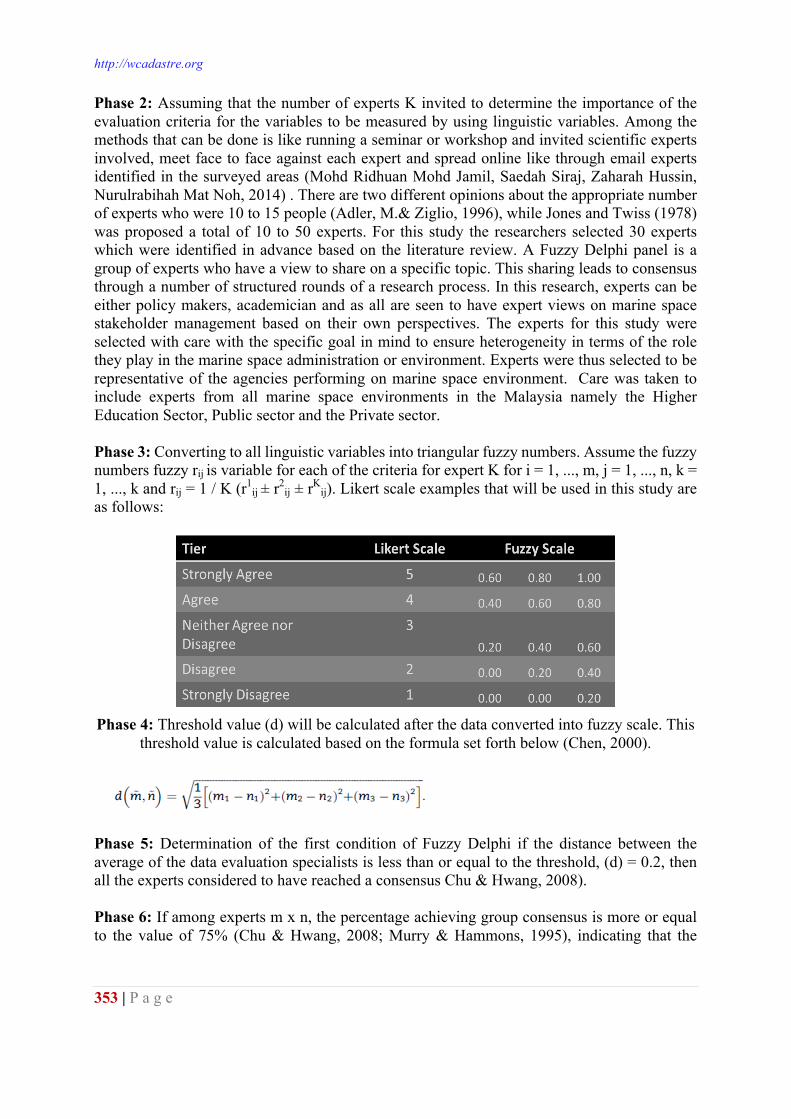
Phase 2: Assuming that the number of experts K invited to determine the importance of the evaluation criteria for the variables to be measured by using linguistic variables. Among the methods that can be done is like running a seminar or workshop and invited scientific experts involved, meet face to face against each expert and spread online like through email experts identified in the surveyed areas (Mohd Ridhuan Mohd Jamil, Saedah Siraj, Zaharah Hussin, Nurulrabihah Mat Noh, 2014) . There are two different opinions about the appropriate number of experts who were 10 to 15 people (Adler, M.& Ziglio, 1996), while Jones and Twiss (1978) was proposed a total of 10 to 50 experts. For this study the researchers selected 30 experts which were identified in advance based on the literature review. A Fuzzy Delphi panel is a group of experts who have a view to share on a specific topic. This sharing leads to consensus through a number of structured rounds of a research process. In this research, experts can be either policy makers, academician and as all are seen to have expert views on marine space stakeholder management based on their own perspectives. The experts for this study were selected with care with the specific goal in mind to ensure heterogeneity in terms of the role they play in the marine space administration or environment. Experts were thus selected to be representative of the agencies performing on marine space environment. Care was taken to include experts from all marine space environments in the Malaysia namely the Higher Education Sector, Public sector and the Private sector. Phase 3: Converting to all linguistic variables into triangular fuzzy numbers. Assume the fuzzy numbers fuzzy rij is variable for each of the criteria for expert K for i = 1, ..., m, j = 1, ..., n, k = 1, ..., k and rij = 1 / K (r1
ij ± r2ij ± rK
ij). Likert scale examples that will be used in this study are as follows:
Phase 4: Threshold value (d) will be calculated after the data converted into fuzzy scale. This
threshold value is calculated based on the formula set forth below (Chen, 2000).
Phase 5: Determination of the first condition of Fuzzy Delphi if the distance between the average of the data evaluation specialists is less than or equal to the threshold, (d) = 0.2, then all the experts considered to have reached a consensus Chu & Hwang, 2008). Phase 6: If among experts m x n, the percentage achieving group consensus is more or equal to the value of 75% (Chu & Hwang, 2008; Murry & Hammons, 1995), indicating that the
Proceedings of the World Cadastre Summit 2015, Istanbul
354 | P a g e
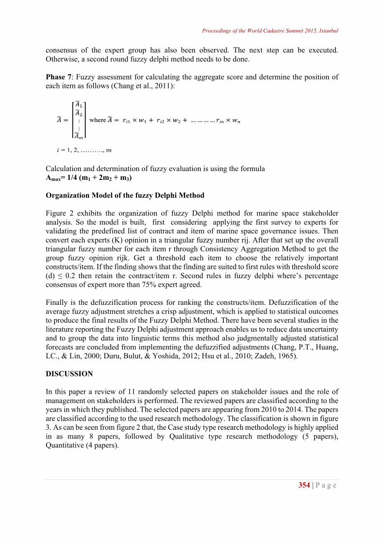
consensus of the expert group has also been observed. The next step can be executed. Otherwise, a second round fuzzy delphi method needs to be done. Phase 7: Fuzzy assessment for calculating the aggregate score and determine the position of each item as follows (Chang et al., 2011):
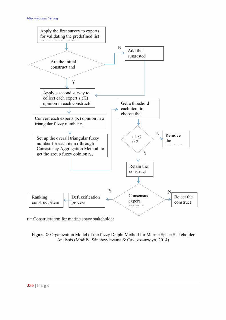
Calculation and determination of fuzzy evaluation is using the formula Amax= 1/4 (m1 + 2m2 + m3) Organization Model of the fuzzy Delphi Method Figure 2 exhibits the organization of fuzzy Delphi method for marine space stakeholder analysis. So the model is built, first considering applying the first survey to experts for validating the predefined list of contract and item of marine space governance issues. Then convert each experts (K) opinion in a triangular fuzzy number rij. After that set up the overall triangular fuzzy number for each item r through Consistency Aggregation Method to get the group fuzzy opinion rijk. Get a threshold each item to choose the relatively important constructs/item. If the finding shows that the finding are suited to first rules with threshold score (d) ≤ 0.2 then retain the contract/item r. Second rules in fuzzy delphi where’s percentage consensus of expert more than 75% expert agreed. Finally is the defuzzification process for ranking the constructs/item. Defuzzification of the average fuzzy adjustment stretches a crisp adjustment, which is applied to statistical outcomes to produce the final results of the Fuzzy Delphi Method. There have been several studies in the literature reporting the Fuzzy Delphi adjustment approach enables us to reduce data uncertainty and to group the data into linguistic terms this method also judgmentally adjusted statistical forecasts are concluded from implementing the defuzzified adjustments (Chang, P.T., Huang, LC., & Lin, 2000; Duru, Bulut, & Yoshida, 2012; Hsu et al., 2010; Zadeh, 1965). DISCUSSION In this paper a review of 11 randomly selected papers on stakeholder issues and the role of management on stakeholders is performed. The reviewed papers are classified according to the years in which they published. The selected papers are appearing from 2010 to 2014. The papers are classified according to the used research methodology. The classification is shown in figure 3. As can be seen from figure 2 that, the Case study type research methodology is highly applied in as many 8 papers, followed by Qualitative type research methodology (5 papers), Quantitative (4 papers).
http://wcadastre.org
355 | P a g e
r = Construct/item for marine space stakeholder
Figure 2: Organization Model of the fuzzy Delphi Method for Marine Space Stakeholder Analysis (Modify: Sánchez-lezama & Cavazos-arroyo, 2014)
N
Y
Retain the construct /item r
dk ≤ 0.2 thres
Apply a second survey to collect each expert’s (K) opinion in each construct/ item (r)
Convert each experts (K) opinion in a triangular fuzzy number rij
Apply the first survey to experts for validating the predefined list of construct and item
Are the initial construct and item enough?
Y
Add the suggested construct and
Get a threshold each item to choose the relatively
Remove the construct
N Set up the overall triangular fuzzy number for each item r through Consistency Aggregation Method to get the group fuzzy opinion rijk
Reject the construct /item r
Consensus expert group ≥
Defuzzification process
N Y Ranking construct /item
Proceedings of the World Cadastre Summit 2015, Istanbul
356 | P a g e
Figure 3: Methodology wise classification of papers Among the plausible explanations for these findings is that Fuzzy Delphi studies were conducted for a minimum number of rounds, without a formal criterion for consensus. Therefore, when authors conclude, as most did, that the results of the study reflect the consensus opinion, it would seem that the achievement of consensus within a Fuzzy Delphi study is implicit to be an integral part of the technique, as has been suggested in the literature (Chang, P.T., Huang, LC., & Lin, 2000; Fasanghari & Montazer, 2008; Glumac, Han, Smeets, & Schaefer, 2009; Jafari, Jafarian, Zareei, & Zaerpour, 2008). The fact that consensus was an important agenda to developed a framework for marine space stakeholder management. Despite the fact that consensus may be the expected outcome of the fuzzy Delphi method, authors believe that there is a distinctness in Fuzzy Delphi Method so o had decided to use it. These findings enhance our understanding of Fuzzy Delphi Method, is a versatile research tool that researchers can employ at various points in their research. Use of the Fuzzy Delphi method for issue identification/prioritization can be valuable in the early stages and end, particularly in selecting the topic and defining the research questions and also the final confirmation of findings. To analyze how stakeholder can impact marine space governance an issue on identification/prioritization is an important stage of analyzing. Our finding revealed that Fuzzy Delphi Method is the best method on this matter. CONCLUSION After analysis of the randomly selected research publications, it is quite evident that no study has been found in the marine space stakeholder context used fuzzy Delphi methodology to developed marine space governance framework by focusing on stakeholder issues. Although there is consistent with findings by Author, we found that Fuzzy Delphi is the ideal method in obtain consensus. In the studied papers a balance between empirical study type papers and conceptual study type papers has been observed. The result of using the fuzzy Delphi method in obtaining consensus for developing framework for marine space stakeholder management e will presented in Authors next paper. In conclusion, Authors also encourages researchers to consider integrating this method in their personal repertoire of research methods so that it is available to them to use as needed to accomplish their research objectives.
1 1 1 1 1
4 5
8
0246810
Methodology
http://wcadastre.org
357 | P a g e
ACKNOWLEDGEMENT The authors would like to express their gratitude to Ministry of Education ,Universiti Teknologi Malaysia (UTM), Jabatan Pengajian Politeknik (JPP) and Fundamental Research Grant Scheme (FRGS) – Ministry of Science, Technology and Innovation (MOSTI) for supporting, funding and contribution respectively. This research is funded by FRGS Fund Vot 4F402. REFERENCES Adler, M.& Ziglio, E. (1996). Gazing into the oracle: the Delphi method and its application to social
policy and public health. London: Jessica Kingsley. Ahmad, Z., Muhidin, M., Wasli, P., Salihin, M., & Mohd, H. (2014). Fuzzy Delphi Analysis for
Future Environmental Education Using Interactive Animation, 2014(February). Boateng, I. (2006). Institutional Frameworks in the Administration of Coast Institutionalal and Marine
Space in Africa. In Administering Marine Spaces: International Issues. Frederiksberg: The International Federation of Surveyors (publication No. 36).
Chang, P.-L., Hsu, C.-W., & Chang, P.-C. (2011). Fuzzy Delphi method for evaluating hydrogen production technologies. International Journal of Hydrogen Energy, 36(21), 14172–14179. doi:10.1016/j.ijhydene.2011.05.045
Chang, P.T., Huang, LC., & Lin, H. J. (2000). The fuzzy delphi method via fuzzy statistic and membership function fitting and an application to the human resources. Fuzzy Sets and Systems, 112(3), 511–520.
Chu, H. C., & Hwang, G. J. (2008). A Delphi-based approach to developing expert systems with the cooperation of multiple experts. Expert Systems with Applications, 34, 2826–2840. doi:10.1016/j.eswa.2007.05.034
Crane, A., & Ruebottom, T. (2012). Stakeholder Theory and Social Identity: Rethinking Stakeholder Identification. Journal of Business Ethics, 102(S1), 77–87. doi:10.1007/s10551-011-1191-4
Damigos, D., & Anyfantis, F. (2011). The value of view through the eyes of real estate experts: A Fuzzy Delphi Approach. Landscape and Urban Planning, 101(2), 171–178. doi:10.1016/j.landurbplan.2011.02.009
Duru, O., Bulut, E., & Yoshida, S. (2012). A fuzzy extended DELPHI method for adjustment of statistical time series prediction: An empirical study on dry bulk freight market case. Expert Systems with Applications, 39(1), 840–848. doi:10.1016/j.eswa.2011.07.082
Elisa, Michael, Tarrant, M. F. (2014). 2014 Marine Spatial Planning in San, (March). Fasanghari, M., & Montazer, G. A. (2008). A Stock Portfolio Selection Method through Fuzzy Delphi,
615–623. Geist, M. R. (2010). Using the Delphi method to engage stakeholders: a comparison of two studies.
Evaluation and Program Planning, 33(2), 147–54. doi:10.1016/j.evalprogplan.2009.06.006 Glumac, B., Han, Q., Smeets, J., & Schaefer, W. (2009). Rethinking Brownfield redevelopment
features : applying Fuzzy Delphi, 1–11. Guru, K., Pengurusan, T., Dan, P., Ridhuan, M., Jamil, M., & Azeez, M. I. K. (2014). Jurnal
kepimpinan pendidikan |, 77–88. Hillman, A. M. Y. J. (2010). SHAREHOLDER VALUE , STAKEHOLDER AND SOCIAL ISSUES :
WHAT ’ S MANAGEMENT , 22(2), 125–139. Hsu, Y.-L., Lee, C.-H., & Kreng, V. B. (2010). The application of Fuzzy Delphi Method and Fuzzy
AHP in lubricant regenerative technology selection. Expert Systems with Applications, 37(1), 419–425. doi:10.1016/j.eswa.2009.05.068
Jafari, A., Jafarian, M., Zareei, A., & Zaerpour, F. (2008). Using Fuzzy Delphi Method in Maintenance Strategy Selection Problem. Journal of Uncertain Systems, 2(4), 289–298.
Le, X.-Q., Vu, V.-H., Hens, L., & Van Heur, B. (2014). Stakeholder perceptions and involvement in the implementation of EMS in ports in Vietnam and Cambodia. Journal of Cleaner Production, 64, 173–193. doi:10.1016/j.jclepro.2013.07.032
Proceedings of the World Cadastre Summit 2015, Istanbul
358 | P a g e
Lin, C. (2013). Application of fuzzy Delphi method (FDM) and fuzzy analytic hierarchy process (FAHP) to criteria weights for fashion design scheme evaluation. International Journal of Clothing Science and Technology, 25(3), 171–183. doi:10.1108/09556221311300192
Liu, W.-H., Ballinger, R. C., Jaleel, A., Wu, C.-C., & Lin, K.-L. (2012). Comparative analysis of institutional and legal basis of marine and coastal management in the East Asian region. Ocean & Coastal Management, 62, 43–53. doi:10.1016/j.ocecoaman.2012.01.005
Luyet, V., Schlaepfer, R., Parlange, M. B., & Buttler, A. (2012). A framework to implement Stakeholder participation in environmental projects. Journal of Environmental Management, 111, 213–9. doi:10.1016/j.jenvman.2012.06.026
Ma, Z., Shao, C., Ma, S., & Ye, Z. (2011). Constructing road safety performance indicators using Fuzzy Delphi Method and Grey Delphi Method. Expert Systems with Applications, 38(3), 1509–1514. doi:10.1016/j.eswa.2010.07.062
Matos, S., & Silvestre, B. S. (2013). Managing stakeholder relations when developing sustainable business models: the case of the Brazilian energy sector. Journal of Cleaner Production, 45, 61–73. doi:10.1016/j.jclepro.2012.04.023
Missonier, S., & Loufrani-Fedida, S. (2014). Stakeholder analysis and engagement in projects: From stakeholder relational perspective to stakeholder relational ontology. International Journal of Project Management, 32(7), 1108–1122. doi:10.1016/j.ijproman.2014.02.010
Mohd Ridhuan Mohd Jamil, Saedah Siraj, Zaharah Hussin, Nurulrabihah Mat Noh, A. A. S. (2014). Pengenalan Asas Kaedah FUZZY DELPHI Dalam Penyelidikan Rekabentuk Pembangunan. (M. I. Agency, Ed.)The Online Journal of Islamic Education (Cetakan Pe., Vol. 2). Monosh Technologies.
Mohd Ridzuan Mohd Jamil, Zaharah Hussin, Nurul Rabihah Mohd Noh, ahmad A. S. and N. A. (2013). Applications of Fuzzy Delphi Method in Educational Research. In D. D. and Z. H. Siraj, Saedah, Norlidah Alias (Ed.), Design and Developmental Research - Emergent Trends in Educational Research (pp. 85–92). Malaysia: Pearson Malaysia Sdn Bhd.
Murry, J. W., & Hammons, J. O. (1995). Delphi: A Versatile Methodology for Conducting Qualitative Research. Review of Higher Education, 18, 423–36. Retrieved from http://search.proquest.com.myaccess.library.utoronto.ca/pao/docview/1308044902/abstract?accountid=14771
Noh, N. M., Siraj, S., & Ridhuan, M. (2013). Design Of Guidelines On The Learning Psychology In The Use Of Facebook As A Medium For Teaching & Learning In Secondary School Faculty of of Malaya Languages and of Malaya, 2(4), 103–111.
Nutters, H. M., & Pinto da Silva, P. (2012a). Fishery stakeholder engagement and marine spatial planning: Lessons from the Rhode Island Ocean SAMP and the Massachusetts Ocean Management Plan. Ocean & Coastal Management, 67, 9–18. doi:10.1016/j.ocecoaman.2012.05.020
Nutters, H. M., & Pinto da Silva, P. (2012b). Fishery stakeholder engagement and marine spatial planning: Lessons from the Rhode Island Ocean SAMP and the Massachusetts Ocean Management Plan. Ocean & Coastal Management, 67, 9–18. doi:10.1016/j.ocecoaman.2012.05.020
Pooyandeh, M., & Marceau, D. J. (2013). A spatial web/agent-based model to support stakeholders’ negotiation regarding land development. Journal of Environmental Management, 129, 309–23. doi:10.1016/j.jenvman.2013.07.028
Ranängen, H., & Zobel, T. (2014). Exploring the path from management systems to stakeholder management in the Swedish mining industry. Journal of Cleaner Production. doi:10.1016/j.jclepro.2014.04.025
Saharuddin, A. H. (2001). National ocean policy—new opportunities for Malaysian ocean development. Marine Policy, 25(6), 427–436. doi:10.1016/S0308-597X(01)00027-6
Sánchez-lezama, A. P., & Cavazos-arroyo, J. (2014). Applying the Fuzzy Delphi Method for determining socio-ecological factors that influence adherence to mammography screening in
http://wcadastre.org
359 | P a g e
rural areas of Mexico Aproximación Fuzzy Delphi para determinar los factores socioecológicos que influyen en la adherencia a la , 30(2), 245–258.
Sang, M. S. (2010). Penyelidikan dalam Pendidikan - Perancangan dan Pelaksanaan Penyelidikan Tindakan. Kuala Lumpur: Penerbitan Multimedia Sdn. Bhd.
Sutherland, M., & Nichols, S. (2006). Administering Marine Spaces : International Issues. In FIG PUBLICATION NO 36.
Tahriri, F., Mousavi, M., Hozhabri Haghighi, S., & Zawiah Md Dawal, S. (2014). The application of fuzzy Delphi and fuzzy inference system in supplier ranking and selection. Journal of Industrial Engineering International, 10(3), 66. doi:10.1007/s40092-014-0066-6
Ter Mors, E., Weenig, M. W. H., Ellemers, N., & Daamen, D. D. L. (2010). Effective communication about complex environmental issues: Perceived quality of information about carbon dioxide capture and storage (CCS) depends on stakeholder collaboration. Journal of Environmental Psychology, 30(4), 347–357. doi:10.1016/j.jenvp.2010.06.001
Tompkins, E. L., Few, R., & Brown, K. (2008). Scenario-based stakeholder engagement: incorporating stakeholders preferences into coastal planning for climate change. Journal of Environmental Management, 88(4), 1580–92. doi:10.1016/j.jenvman.2007.07.025
Van Leeuwen, J., Raakjaer, J., van Hoof, L., van Tatenhove, J., Long, R., & Ounanian, K. (2014). Implementing the Marine Strategy Framework Directive: A policy perspective on regulatory, institutional and stakeholder impediments to effective implementation. Marine Policy, 1–6. doi:10.1016/j.marpol.2014.03.004
Waligo, V. M., Clarke, J., & Hawkins, R. (2013). Implementing sustainable tourism: A multi-stakeholder involvement management framework. Tourism Management, 36, 342–353. doi:10.1016/j.tourman.2012.10.008
Waligo, V. M., Clarke, J., & Hawkins, R. (2014). The “Leadership–Stakeholder Involvement Capacity” nexus in stakeholder management. Journal of Business Research, 67(7), 1342–1352. doi:10.1016/j.jbusres.2013.08.019
Wang, Y., Yeo, G.-T., & Ng, A. K. Y. (2014). Choosing optimal bunkering ports for liner shipping companies: A hybrid Fuzzy-Delphi–TOPSIS approach. Transport Policy, 35, 358–365. doi:10.1016/j.tranpol.2014.04.009
Zadeh, L. A. (1965). Fuzzy sets. Information and Control, 8, 338–353.
Proceedings of the World Cadastre Summit 2015, Istanbul
360 | P a g e
MARINE CADASTRE LEGAL FRAMEWORK FOR MALAYSIA
Ashraf Abdullah1, Zakaria Mat Arof1, Abdullah Hisam Omar2, Nazirah Mohamad
Abdullah2 , Chee Hua Teng3, Keat Lim Chan3, Hassan Jamil3
1Department of Geomatic Science and Surveying, Faculty of Architecture, Planning and Surveying, University Teknologi MARA (Perlis), 02600 Arau, Perlis, Malaysia.
[email protected] 2Department of Geoinformation, Faculty of Geoinformation and Real Estate, University of
Teknologi Malaysia, 81310 Johor Bahru, Johor, Malaysia 3Department of Surveying and Mapping Malaysia, Jabatan Ukur Dan Pemetaan Malaysia,
Wisma JUPEM, Jalan Semarak, 50578 Kuala Lumpur. [email protected]
ABSTRACT Malaysia is the maritime country and has a long coastline of about 4,384 km which is about 1,823 km in the peninsula and the rest of 2561 km in Sabah and Sarawak This situation requires Malaysia to a better management of the marine space for marine activities in line with the concept of sustainable development. This paper underlines the highlighted pertaining issues which are related to legal framework in the implementation of marine cadastre in Malaysia. The various activities through the discussion and meetings with marine stakeholders and the focus group have been conducted. The resolutions and decision was made according the situation, cases, and activities in marine area and pertaining to related law. The result show that the detail about marine space needs to be further elaborated and legalized. The proper legal framework is finely requires to ensure the smooth implementation of the system running without the argument from any parties involved. From this study, the new marine cadastre legal framework was proposed regarding to existing legal towards the realization of marine cadastre practices in future and under the marine alienation perspective. Key words: marine cadastre, marine alienation, legal, national, administration INTRODUCTION The coastal Malays in particular regarded the seas as natural appurtenances to the land they occupy. Sovereign Nations exercised absolute sovereignty and jurisdiction in seas covering the whole of sovereignty area of Malaysia. The seas surrounding the land played a significant role in the defence, economic, and political matters of the nation concerned. The sovereignty of nation depend on concept of unity between land and water expressed by the Malay word ‘tanahair’ which literally means land and water is depict to the meaning of native land. Such was already the significance and appreciation of the seas in this region. As early as 1276 during the reign of Sultan Muhammed Shah the first sovereign of the Malacca Sultanate - it was found that the Malays had already designed a set of laws of the sea applicable in sea areas within the jurisdiction of the Malacca Sultanate. These laws were referred to as the Malaca Code.
http://wcadastre.org
361 | P a g e
Furthermore, introduction of marine cadastre is a new kinds of sea uses, spatial extension of ongoing sea uses and the need to better protect and better arrangement of marine parcel for various users, as well as between the users and the environment. Marine cadastre legal framework is the process to define the marine alienation and marine spatial planning to allocate space for specific uses which can help to avoid user conflicts, to improve the management of marine spatial claim and sustain an ecosystem-based management of ocean. However, the law is less relevant in the recent days. Current practices on handling the marines rights is not much different with on the ground. Marine phenomena in 3D parcel is actually differ and should be treated separately. This paper examines the overview of marine cadastre issues in Malaysia related to international law, the governing law, Malaysia law in land matters such as National Land Code 1965 and the propose the marine cadastre legal framework for Malaysia and several topics to amendment in NLC1965. MARINE CADASTRE IN MALAYSIA As a maritime country Malaysia had joined as a member in the Law of the Sea Convention of 1982. Marine cadastre in Malaysia was define as follows: A marine cadastre is a 3D marine parcel administration system with respect to the legal and systematic technical arrangement of marine spatial rights, restrictions and responsibilities for marine space activities covering marine natural resources, marine industry, tourism and national sea park and wildlife conservations (Ashraf et al., 2013). This definition is including the agenda of integrated coastal and marine resources management within the land policy and ocean policy framework. That is why the requirement of legal framework is needed to ensure the the ability to achieve goals to be reality. From the study literature review, the focus of implementation in marine cadastre elements currently practices and carried out but not in right perspective. That is lacking due in term of legal aspect to address several issues in right matters that can be disputed by various parties. In addition from impact of related legal needed, the technical aspects are still to be limitations where no specific procedure has been taken to put in place measures that will provide transparency, accuracy and clearly on data presentation and information display to all parties involved with the marine environment. The implementation of marine cadastre needs the level of law to put the marine cadastre in which level of implementation. Marine cadastre element is proposed to enter in the existing legal such as National Land Code 1965 where this legislation is main reference for Peninsular Malaysia but must have some modification in marine elements aspects. In Malaysia territorial water, the huge issues is in the territorial water description and the separation of power between Federal and State. In current situation, Malaysia create the new act for territorial water administration and enforce at 22 June 2012 for whole of Malaysia. This issue was continuation from replacement the Emergency (Essential Powers) Ordinance, No. 7 1969 P.U (A)307A/1969 as mentioned above to make a new jurisdiction and not under the Emergency Proclamation 1969. The Malaysia Government takes a decision to scatter three the Emergency Proclamation. The three of Emergency Proclamation is The Emergency Proclamation 1966, the Emergency Proclamation 1969 and the Emergency Proclamation 1979. Under this action, all of three Emergency Proclamation was stopped immediately and on the date 24thNovember 2011 the Dewan Rakyat was approved that all the three Proclamation was terminated on 20 Disember 2011 also done by Dewan Negara. From this condition, the new act
Proceedings of the World Cadastre Summit 2015, Istanbul
362 | P a g e
must be established to conserve Malaysian territorial waters. But from the content of new act, the consideration was similar to (Essential Powers) Ordinance, No. 7 1969 P.U (A)307A/1969 but have some changes about description in term of definition and applications and ensuring parallel to UNCLOS 1982 In this act, the conclusion it is a continuation of the Emergency Ordinance 1969 and translated into a new act since the establishment of the Ordinance is not relevant in the present situation and formulated according to the event last year. Here are some excerpts contained in this Act relating to the functions and powers between the federal and state administration. According to the statement: Paragraph 3 (1) which is related to marine territorial limits of Malaysia is like - Subject to the provisions of this Act, the width of the territorial sea of 12 nautical miles Malaysia shall for all purposes. Statement under 3(2) are mentioned about the baseline issue as stated in the quote : The baselines from which the breadth of that territorial sea is to be measured shall for all purposes be those established in accordance with section 5 of the Baseline of Maritime Zones Act 2006. Regarding to Section 5 Baseline of Maritime Zone Act 2006 state that as below 5(1) Subject to subsection (2), the baselines for the purpose of determining the maritime zones of Malaysia shall be- (a) low-water line along the coast as marked on large scale charts; (b) Seaward low-water line of a reef as shown by the appropriate symbol on charts; or (c) low-water line on a low-tide elevation that is situated wholly or partly at a distance not exceeding the breadth of the territorial sea from the mainland or an island. 5(2) Not withstanding subsection (1), in respect of any area for which geographical co-ordinates of base points have been declared under section 4, the method of straight baselines interpreted as geodesics joining the consecutive geographical coordinates of base points so declared may be employed for determining the maritime zones of Malaysia. The above indicative of the position of Malaysia recognizes the low-water line is a line on which the determination of the maritime boundaries with consideration of the matters referred to three situation of low-water line and the first situations is the position of low water line were identified and marked on the map scale, position seaward low-water line of a reef or authenticity of essays with the symbol shown on the map and the position of the low-water line where the low-tide elevation in whole or in part is not more than 12 nautical miles from the mainland or island position. In other issues, Malaysia was created the Exclusive Economic Zone 1984 Act which is focusing on determination and declaration the matters of Malaysia mastery in maritime area. In EEZ 1984, under the Section 3 (1) The exclusive economic zone of Malaysia as proclaimed by the King of Malaysia vide P.U(A) 115/80 is an area beyond and adjacent to the territorial sea of Malaysia and subject to subsections (2) and (4) extends to a distance of two hundred nautical miles from the baseline from which the breadth of the territorial sea is measured. Subsection (2) mention that where the there is an agreement in force on the matter between Malaysia and a State with an opposite or adjacent coast, questions relating to the delimitation of the exclusive economic zone shall be determined in accordance with the provisions of that agreement. Subsection (4) where having regard to international law, state practice or an agreement referred to in sub-section(2) the King of Malaysia can considers its necessary so to
http://wcadastre.org
363 | P a g e
do , he may by order published in the Gazette alter the limits of the exclusive economic zone determined in accordance with subsection(1).Malaysia is a federal state with marine jurisdiction and management responsibility split between the states and the central (federal) government. The amendments to the Emergency (Essential Powers) Ordinance, No7 1969 states that territorial water shall be constructed as a reference to such part of the sea adjacent to control the coast thereof not exceeding 3 nautical miles measured from low water mark. In this situation, the state control up to 3 nautical miles from low water mark whilst the federal government has jurisdiction and management responsibility from the said 3 nautical miles limits to the outer edge of the EEZ and continental shelf. By on 22th June 2012, The Emergency (Essential Powers) Ordinance, No. 7 1969 (P.U.(A)307 A/1969) was withdraw of power after the Territorial Water Act 2012 was established. This act is to create the Malaysia territorial water to replace the existing, The Emergency (Essential Powers) Ordinance, No. 7 1969 (P.U. (A)307 A/1969 were established under Emergency Proclamation 1969. In other issues, Malaysia also has lacking due to the LAT demarcation because not ready in proper marine legal about the determination of LAT and not highlighted the important of big scale mapping in coastal area although stated in Territorial Water Act 2012. Moreover, the legal documentation is a part of important in several issues involved the marine cadastre elements and aspect, and in Malaysia is no provision was established. It is needed to supporting the policy, rules and regulation for implementation which is it important in relating the marine alienation issues. Malaysia was practices the marine alienation indirectly and that practices is not occurred in suitable marine area and environment under the marine spatial management context. This is lacking due to zoning issue about the marine alienation involved in rights purposes that are applicable. UNITED NATION LAW OF THE SEA 1982 RELATED TO NATIONAL MARINE REGIME The administration of marine area in Malaysia is governed by legally defined boundaries and follows United Nations Convention on the Law of the Sea (UNCLOS) which is Malaysia itself can claim, manage and utilize its maritime territories (United Nations, 1983). Based on Country Report on Administering the Marine Environment by Ahmad Fauzi Nordin, 2006, Malaysia ratified UNCLOS in October 1996.In line with provisions of UNCLOS, is :
i. The Territorial Sea, which is the belt of sea measured 12 nautical miles (nm) seaward from the territorial sea baseline. On 2ndAugust 1969 an Ordinance under Article 150(2) of the Constitution known as the Emergency (Essential Powers) Ordinance, No.7, 1969 was promulgated. Under this Ordinance, the territorial waters of Malaysia (except in the Straits of Malacca, the Sulu Sea and the Celebes Sea) were declared as 12 nautical miles from the base line determined in accordance with UNCLOS.
ii. The contiguous zone which is the belt of sea, contiguous to the territorial sea, measured 24Nm seaward from the Territorial Sea Baseline.
iii. The Exclusive Economic Zone, which is the area beyond and adjacent to the territorial sea, measured 200Nm seaward from the Territorial Sea Baseline.
This provision is important to guide the marine cadastre implementation in term of legal aspect to ensure that focus of practices must parallel to UNCLOS 1982 although that legal created
Proceedings of the World Cadastre Summit 2015, Istanbul
364 | P a g e
focusing on local perspective. Malaysia rectified the UNCLOS 1982 on 14thOctober 1996 and highlighted the baseline and maritime limitation shown by the big scale chart presented by the list of base point with the geodetic datum. In the context of determination of base point and baseline, Malaysia was practices the straight base line approach. Hence, through the endorsement of Baseline of Maritime Zone Act 2006, the Malaysian baselines was established by Malaysian Government and deposit them into United Nation Convention to ensure the sovereignty of Malaysia maritime boundary was declared and avoid the conflict on the next future. NATIONAL LAND CODE 1965 IN MALAYSIA Until now, Malaysia was established 77 national laws pertain to marine matters covering diverse matters related to marine activities such as shipping, navigation, transportation, petroleum and others. The list of national laws pertaining to marine matters is attached at Appendix A. This paper focuses on National Land Code(NLC) 1965 because it was main refference and discussing on land matters in Peninsular Malaysia. NLC 1965 come into force from January 1, 1966 and contains 447 sections, 16 schedules, 6 divisions, 35 divisions and have been through about many amendments regarding the current issues.NLC1965 is nearly 48 years old and it is largely a re-enactment of earlier laws. National Land Code 1965 has undergone many changes and revisions and the latest was in February 2012 In regards to delivery system where there are more than 40 times the scale of amendments to the National Land Code, which was performed when there is an urgent need to address issues land administration. Latest amendments effected on the National Land Code 2008 can be a launching pad to the evolution of electronic land administration system for the states of Peninsular Malaysia. However, the NLC 1965 governs mainly for land administration purposes and its authority cover until HAT situation and not discussing in details beyond that situation especially on marine environment. The purpose of marine cadastre is not there and need the revision and amendments to answering the issues of marine cadastre. NLC1965 is still relevant to marine cadastre as a new practice on the water issues and limits. It needed in marine cadastre practices to amended through a special modification of any statement in related section which are connected and can be correlated with the marine cadastre factors. THE INTEGRATION OF INSTITUTION IN MARINE CADASTRE FROM MALAYSIA PERSPECTIVE However, efforts in establishing the perfect implementation of marine cadastre as a practice have been carried out over the past five years. Below in Figure 1 was shown a resolution issued as a clear picture of the marine cadastre relate to general concept from Malaysia perspective to proposed and the connection to main institutions which is suggested to driving the marine cadastre very well. Figure 1 shows there are five main components that support the general concept of marine cadastre where it covers the legal, institutional and organizational, technical aspects, the social and economic impact and sustainable development. From this aspect of the proposed major institutions involved in marine alienation is where a combination of federal and state governments work in two main aspects related to the law and institutions involved under the law stated. This state of things between federal authority and state where under 3 nautical miles
http://wcadastre.org
365 | P a g e
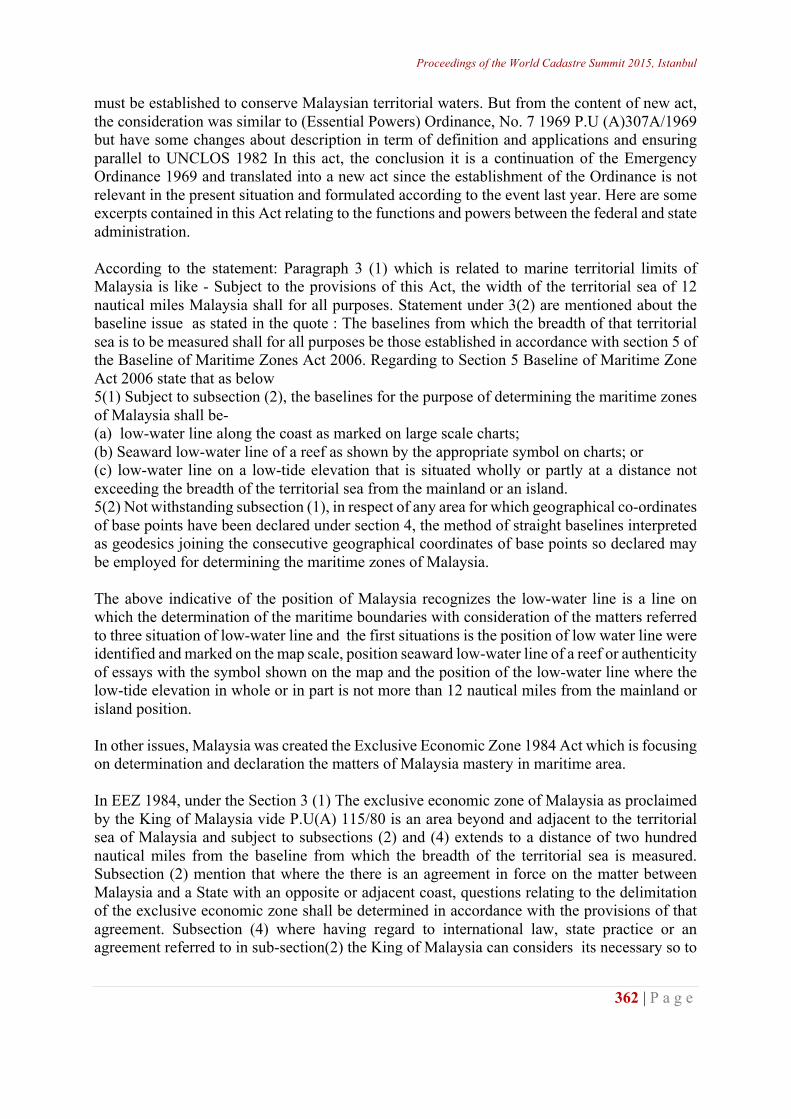
dependent on the power of the state and the State Director of Lands beyond 3 nautical miles under the Director General of the Department of Land and Minerals. For technical management, DSMM is the most appropriate institution to highlight the best technical methods to produce a robust procedure in the production of marine title. Marine cadastre also requires that institutions make a detailed study to look at the social and generating profits realized from the implementation of the marine cadastre. In addition, marine environmental should always be supervised properly established ecosystem as well as development activities. Therefore, for sustainable development has been proposed for the Ministry of natural resources and the environment to put the responsibility for carrying out the specific control activities to ensure that the marine natural resources are not damaged and cause a loss in the country.
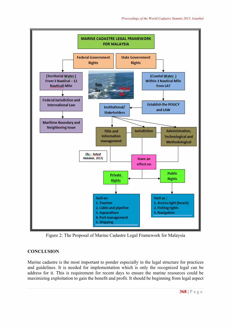
Figure 1: Marine Cadastre Component and Institution Involved THE PROPOSAL OF MARINE CADASTRE LEGAL FRAMEWORK For the purposes of marine cadastre in Malaysia, the picture below shows a proposed legal framework that to are structuring of marine cadastre applications in Malaysia. The figure below shows the position of the marine cadastre placed in two administrative authorities is clearly stated in the Territorial Water Bill 2012. For the implementation of the marine cadastre in Malaysia, it is proposed implementation in their positions only three nautical miles of the State
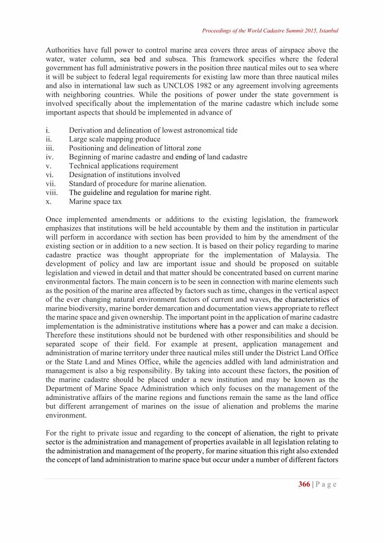
Proceedings of the World Cadastre Summit 2015, Istanbul
366 | P a g e
Authorities have full power to control marine area covers three areas of airspace above the water, water column, sea bed and subsea. This framework specifies where the federal government has full administrative powers in the position three nautical miles out to sea where it will be subject to federal legal requirements for existing law more than three nautical miles and also in international law such as UNCLOS 1982 or any agreement involving agreements with neighboring countries. While the positions of power under the state government is involved specifically about the implementation of the marine cadastre which include some important aspects that should be implemented in advance of i. Derivation and delineation of lowest astronomical tide ii. Large scale mapping produce iii. Positioning and delineation of littoral zone iv. Beginning of marine cadastre and ending of land cadastre v. Technical applications requirement vi. Designation of institutions involved vii. Standard of procedure for marine alienation. viii. The guideline and regulation for marine right. x. Marine space tax Once implemented amendments or additions to the existing legislation, the framework emphasizes that institutions will be held accountable by them and the institution in particular will perform in accordance with section has been provided to him by the amendment of the existing section or in addition to a new section. It is based on their policy regarding to marine cadastre practice was thought appropriate for the implementation of Malaysia. The development of policy and law are important issue and should be proposed on suitable legislation and viewed in detail and that matter should be concentrated based on current marine environmental factors. The main concern is to be seen in connection with marine elements such as the position of the marine area affected by factors such as time, changes in the vertical aspect of the ever changing natural environment factors of current and waves, the characteristics of marine biodiversity, marine border demarcation and documentation views appropriate to reflect the marine space and given ownership. The important point in the application of marine cadastre implementation is the administrative institutions where has a power and can make a decision. Therefore these institutions should not be burdened with other responsibilities and should be separated scope of their field. For example at present, application management and administration of marine territory under three nautical miles still under the District Land Office or the State Land and Mines Office, while the agencies addled with land administration and management is also a big responsibility. By taking into account these factors, the position of the marine cadastre should be placed under a new institution and may be known as the Department of Marine Space Administration which only focuses on the management of the administrative affairs of the marine regions and functions remain the same as the land office but different arrangement of marines on the issue of alienation and problems the marine environment. For the right to private issue and regarding to the concept of alienation, the right to private sector is the administration and management of properties available in all legislation relating to the administration and management of the property, for marine situation this right also extended the concept of land administration to marine space but occur under a number of different factors
http://wcadastre.org
367 | P a g e
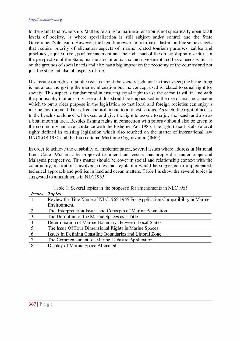
to the grant land ownership. Matters relating to marine alienation is not specifically open to all levels of society, is where specialization is still subject under control and the State Government's decision. However, the legal framework of marine cadastral outline some aspects that require priority of alienation aspects of marine related tourism purposes, cables and pipelines , aquaculture , port management and the right part of the cruise shipping sector . In the perspective of the State, marine alienation is a sound investment and basic needs which is on the grounds of social needs and also has a big impact on the economy of the country and not just the state but also all aspects of life. Discussing on rights to public issue is about the society right and in this aspect; the basic thing is not about the giving the marine alienation but the concept used is related to equal right for society. This aspect is fundamental in ensuring equal right to use the ocean is still in line with the philosophy that ocean is free and this should be emphasized in the use of marine space in which to put a clear purpose in the legislation so that local and foreign societies can enjoy a marine environment that is free and not bound to any restrictions. As such, the right of access to the beach should not be blocked, and give the right to people to enjoy the beach and also as a boat mooring area. Besides fishing rights in connection with priority should also be given to the community and in accordance with the Fisheries Act 1985. The right to sail is also a civil rights defined in existing legislation which also touched on the matter of international law UNCLOS 1982 and the International Maritime Organization (IMO). In order to achieve the capability of implementation, several issues where address in National Land Code 1965 must be proposed to amend and ensure that proposal is under scope and Malaysia perspective. This matter should be cover in social and relationship context with the community, institutions involved, rules and regulation would be suggested to implemented, technical approach and politics in land and ocean matters. Table I is show the several topics in suggested to amendments in NLC1965.
Table 1: Several topics in the proposed for amendments in NLC1965 Issues Topics 1 Review the Title Name of NLC1965 1965 For Application Compatibility in Marine
Environment. 2 The Interpretation Issues and Concepts of Marine Alienation 3 The Definition of the Marine Spaces as a Title 4 Determination of Marine Boundary Between Local States 5 The Issue Of Four Dimensional Rights in Marine Spaces 6 Issues in Defining Coastline Boundaries and Littoral Zone 7 The Commencement of Marine Cadastre Applications 8 Display of Marine Space Alienated
Proceedings of the World Cadastre Summit 2015, Istanbul
368 | P a g e
Figure 2: The Proposal of Marine Cadastre Legal Framework for Malaysia
CONCLUSION Marine cadastre is the most important to ponder especially in the legal structure for practices and guidelines. It is needed for implementation which is only the recognized legal can be address for it. This is requirement for recent days to ensure the marine resources could be maximizing exploitation to gain the benefit and profit. It should be beginning from legal aspect
http://wcadastre.org
369 | P a g e
as the driver the great implementation and solution in order to answering all the problems facing and need to update follows the changing of requirements and marine environments itself. This paper is very important and as the starting point to look deeper in term of legal involving and requires emphasis to ensure marine cadastre can be reality soon. Generally, marine cadastre is the platform to exploits as new resource for government and public to share the natural awards to them in creating the better life for future. REFERENCES Ahmad Fauzi Nordin (2006). Country Report on Marine Administration. JUPEM Pg. 23-27. A.Ashraf,(2004). Master Thesis: Pengkonsepsualan Kadaster Marine di Malaysia. UTM Skudai A.Ashraf, M.A. Zakaria (2008) Development of Marine Cadastre Model and Conceptual in
Malaysia..UiTM Perlis. Perlis. Fowler, C., & Treml, E. (2001). Building a marinecadastral information system for the United States --
a case study. Computers, Environment and Urban Systems, 25(4-5), 493-507. Liu, W.-H., Wu, C.-C., Jhan, H.-T., & Ho, C.-H. (2011). The role of local Government in marine
spatial planning and management in Taiwan. Marine Policy, 35(2), 105-115. National Oceanography Directorate, Malaysia Ocean Policy 2011-2020.(2011) Ministry of Science,
Technology and Innovation, Malaysia Ng'ang'a, S., Sutherland, M., Cockburn, S., & Nichols, S. (2004). Toward A 3D Marine Cadastre In
Support Of Good Ocean Governance: A Review Of The Technical Framework Requirement S. Computers, Environment and Urban Systems, 28(5), 443-470.
Strain, L., Rajabifard, A., & Williamson, I. (2006). Marine administration and spatial data infrastructure. Marine Policy, 30(4), 431-441.
Rizqi Abdulharis, Eka Djunarsjah And Andri Hernandi,(2008) Stakeholder Analysis On Implementation Of Marine Cadastre In Indonesia .FIG Working Week 2008 Stockholm, Sweden 14-19 June 2008
National Land Code 1965 (Act 56/1965) Kedah State Land Rule 1966 Fowler, C., & Treml, E. (2001). Building A Marine Cadastral Information System For The United
States -- A Case Study. [doi: DOI: 10.1016/S0198-9715(00)00047-8]. Computers, Environment and Urban Systems, 25(4-5), 493-507.
Sutherland M (2011) Implementing a Marine Cadastre. University of the West Indies st Augustine. Trinidad Tobago. South East Asia survey Congress.
Appendix A
NO CATEGORY LAWS AND REGULATIONS 1 Port Ø Penang Port Commission Act1955(Act 140)
Ø Port Authorities Act, 1963(Act 488) Ø Port Workers (Regulations of Employment),2000(Act607) Ø Sabah Port Authority (Consequential Provisions) Act 1968(Act25) Ø Declaration of an Area in Bintulu District to be a Federal Port Act
1979(Act217) Ø Bintulu Port Authority Act 1981(Act243) Ø Ports (Privatisation)Act 1990(Act422)
2 Shipping Ø Carriage of Goods by Sea Act, 1950(Act527) Ø Merchant Shipping Ordinance, 1952 Ø Merchant Shipping Ordinance, 1960(Sabah) Ø Merchant shipping Ordinance, 1960(Sarawak) Ø State Boat Rules
3 Light House Ø Federation Light Dues Act,1953(Act 250) 4 Non Living
Resources Ø Petroleum Mining Act, 1966(Act95) Ø Petroleum Development Act, 1974(Act144)
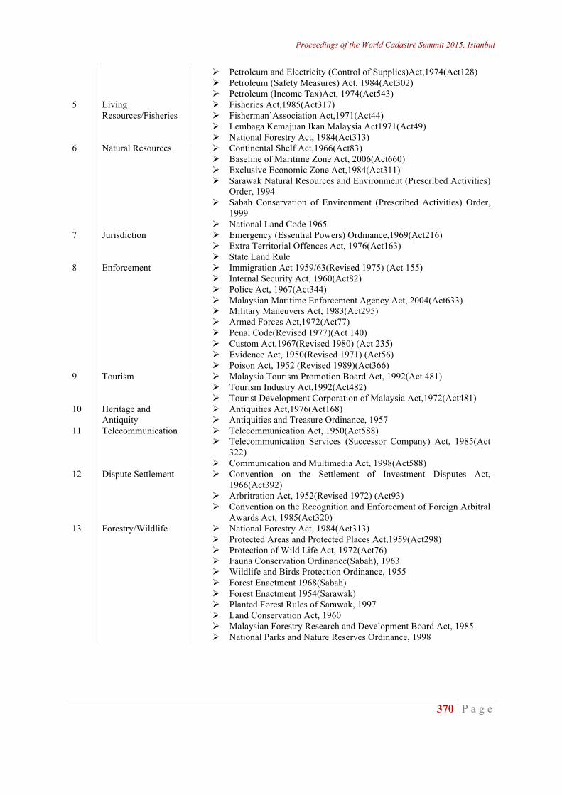
Proceedings of the World Cadastre Summit 2015, Istanbul
370 | P a g e
Ø Petroleum and Electricity (Control of Supplies)Act,1974(Act128) Ø Petroleum (Safety Measures) Act, 1984(Act302) Ø Petroleum (Income Tax)Act, 1974(Act543)
5 Living Resources/Fisheries
Ø Fisheries Act,1985(Act317) Ø Fisherman’Association Act,1971(Act44) Ø Lembaga Kemajuan Ikan Malaysia Act1971(Act49) Ø National Forestry Act, 1984(Act313)
6 Natural Resources Ø Continental Shelf Act,1966(Act83) Ø Baseline of Maritime Zone Act, 2006(Act660) Ø Exclusive Economic Zone Act,1984(Act311) Ø Sarawak Natural Resources and Environment (Prescribed Activities)
Order, 1994 Ø Sabah Conservation of Environment (Prescribed Activities) Order,
1999 Ø National Land Code 1965
7 Jurisdiction Ø Emergency (Essential Powers) Ordinance,1969(Act216) Ø Extra Territorial Offences Act, 1976(Act163) Ø State Land Rule
8 Enforcement Ø Immigration Act 1959/63(Revised 1975) (Act 155) Ø Internal Security Act, 1960(Act82) Ø Police Act, 1967(Act344) Ø Malaysian Maritime Enforcement Agency Act, 2004(Act633) Ø Military Maneuvers Act, 1983(Act295) Ø Armed Forces Act,1972(Act77) Ø Penal Code(Revised 1977)(Act 140) Ø Custom Act,1967(Revised 1980) (Act 235) Ø Evidence Act, 1950(Revised 1971) (Act56) Ø Poison Act, 1952 (Revised 1989)(Act366)
9 Tourism Ø Malaysia Tourism Promotion Board Act, 1992(Act 481) Ø Tourism Industry Act,1992(Act482) Ø Tourist Development Corporation of Malaysia Act,1972(Act481)
10 Heritage and Antiquity
Ø Antiquities Act,1976(Act168) Ø Antiquities and Treasure Ordinance, 1957
11 Telecommunication Ø Telecommunication Act, 1950(Act588) Ø Telecommunication Services (Successor Company) Act, 1985(Act
322) Ø Communication and Multimedia Act, 1998(Act588)
12 Dispute Settlement Ø Convention on the Settlement of Investment Disputes Act, 1966(Act392)
Ø Arbritration Act, 1952(Revised 1972) (Act93) Ø Convention on the Recognition and Enforcement of Foreign Arbitral
Awards Act, 1985(Act320) 13 Forestry/Wildlife Ø National Forestry Act, 1984(Act313)
Ø Protected Areas and Protected Places Act,1959(Act298) Ø Protection of Wild Life Act, 1972(Act76) Ø Fauna Conservation Ordinance(Sabah), 1963 Ø Wildlife and Birds Protection Ordinance, 1955 Ø Forest Enactment 1968(Sabah) Ø Forest Enactment 1954(Sarawak) Ø Planted Forest Rules of Sarawak, 1997 Ø Land Conservation Act, 1960 Ø Malaysian Forestry Research and Development Board Act, 1985 Ø National Parks and Nature Reserves Ordinance, 1998
http://wcadastre.org
371 | P a g e
DENİZEL ALAN COĞRAFİ BİLGİ SİSTEMİ İÇİN KADASTRO VERİ MODELİ TASARIMI: TRABZON İLİ
ÖRNEĞİ
Recep Nisanci, Yasar Selcuk Erbas, Bayram Uzun, Volkan Yildirim, Husniye Ebru Colak, Sevket Bediroglu
KTU Harita Muhendisligi GISLab, Trabzon, Turkey - [email protected]
ÖZET Üç tarafı denizlerle çevrili ülkemizin denizel alanlarına yönelik sürdürülebilir çevre yönetimi için denizel ve kıyı alanlarına ait konumsal bilgiye ihtiyaç vardır. Bilgi çağı olarak adlandırılan günümüzde, bilgiyi toplamak ve analiz etmek; doğru, hızlı ve ekonomik kararlar verebilmenin öncelikli gerekliliklerinden biridir. Denizel alanlar, deniz tabanı, deniz yüzeyi ve kıyıyı da içeren yoğun bir konumsal veri kümesine sahiptir. Denizel alanlara yönelik yönetişim bağlamında farklı kurumlar için yasal düzenlemeler vardır. İyi bir yönetişimde yoğun bilgi kümesinin en iyi bir şekilde analizini gerektirir. İdeal bir denizel alan ve kıyı yönetimi için günümüze kadar yapılan karasal ölçümlerin yanında gelecekte denizel alanların ölçümü ve kayıtlarının da gerçekleştirileceği açıktır. Denizel ve kıyı alanlarının da karasal alanlar gibi kayıt altına alınması, kullanım haklarının ve sınırlarının belirlenmesi hukuki, sosyal ve ekonomik bir gereklilik olduğu kadar sürdürülebilir bir deniz yönetimi için de gereklidir. Bu çalışmanın temel amacı, denizel alanların sürdürülebilir yönetimi ve denizel alan CBS için, temel harita altlıkları ve denizel alanların planlanmasına yönelik konumsal veri modelinin bilgi teknolojileri desteği ile tasarlanmasını sağlamaktır. CADASTRAL DATA MODEL DESIGN FOR THE MARINE AREA GEOGRAPHIC INFORMATION SYSTEM: THE TRABZON EXPERIENCE ABSTRACT Marine spatial data is needed for a sustainable environmental management of marine and coastal areas in Turkey, surrounded largely by sea. In the contemporary time, called as information age, data/information acquisition and analysis are prerequisites for rapid, precise and economical decision making. Marine areas have intensive information sets including sea bed, sea surface and coastal areas. In the context of marine governance, there are different legal arrangements for different foundations or government bodies. For good governance, intensive information sets are required to be effectively analysed. For an ideal management of marine areas and coastal, in addition to previous terrestrial surveying activities, it is evident that surveying and registration of marine areas will be carried out in the future. Registration of marine and coastal areas and related rights and boundaries similar to terrestrial areas is a legal, social and economical requirement and also required for sustainable marine and coastal management. The basic aim of this study is ensuring that the design of basic mapping coverage
Proceedings of the World Cadastre Summit 2015, Istanbul
372 | P a g e
and cadastral data model for planning marine areas with support of information technologies for sustainable management of marine area and GIS of marine area. Key words: Marine Cadastre, Marine Area, Geographic Information System, GIS. GİRİŞ Deniz ve kıyı alanları, birbirleriyle ilişkili olan ve insanlığın ortak yaşam alanlarının en önemli alanlarıdır. Dünya nüfusunun üçte ikisi yaşamını kıyı bölgelerinde sürdürmektedir. Deniz ve kıyı bilimcilerine göre büyük kentler kıyı bölgelerine kurulmuş olup dünya genel nüfusun yarısı deniz kıyısında yaşamaktadır (Cicin-Sain vd., 1998). Birleşmiş Milletler verilerine göre gelecek 50 yıl içersinde 6,3 milyar kişi deniz kıyısında yaşıyor olacaktır (BM Nüfus Raporu, 2000). Denizler yaklaşık olarak yeryüzünün üçte ikisini kaplamaktadır. BM verilerini göz önünde bulundurduğumuzda, deniz alanlarının yaşam alanına dönüştürülmesi için baskı altına alınacağı görülmektedir (Widodo, 2003). Kıyı ve deniz alanları insanların refahı için büyük öneme sahiptir. Tarih boyunca kıyılar ve denizler, gerek ekonomik gerekse kültürel anlamda en çok tercih edilen alanlar olmuş, ülkelerin kalkınmasında önemli roller üstlenmişlerdir. Geleneksel olarak, okyanusların kullanım hakları, kıyı sularının/kesimlerinin kontrol edilmesi amacıyla ülkelere ait deniz donanmalarınca elde tutulmaktadır. Mülklerin korunması ya da genişletilmesi üzerinde etkili olan nasyonalizm duygusu; okyanusların bölümlenmesi, canlı deniz kaynakları ve deniz zeminindeki kum ve mineral kaynakları gibi bir takım hakların varlığını ortaya çıkarmıştır. Haritalama uygulamalarındaki Küresel Konumlama Sistemi (GPS), Coğrafi Bilgi Sistemi (CBS) ve Elektronik Haritalama Gösterim Bilgi Sistemi (ECDIS) gibi gelişen teknolojik sistemler yukarıda bahsedilen hakların sınırlandırılması için okyanus sınırlarının belirlenmesini daha kapsamlı ele almaktadır. Günümüzde, denizciler yön hesaplamalarında eski zamanlardaki yöntemleri kullanarak hassas konumlama yapabilmektedirler. Madencilik teknolojisindeki gelişmeler kıyısal alanlardaki mineral kaynaklarının çıkarımı ticaretini arttırmıştır. Bunun sonucunda deniz yüzeyi haritalarının doğruluğu için yapılan baskılar da artmıştır. Geçmişte petrol, gaz ve sülfür madenciliği yapılmıştır. Günümüzde ise kıyı alanlarında gerçekleştirilecek projeler büyük önem arz etmektedir. Tüketilen deniz kaynakları ve insan kaynaklı kirlenmenin artması birçok ülkede kıyısal alanların kapsamlı olarak planlanmasına ve bu yöndeki yasal yaptırımların uygulanmasına olanak sunmaktadır. Sonuç olarak doğru, kullanılabilir ve erişilebilen karasal haklarla tanımlı dijital deniz sınırları ihtiyacı günümüz okyanus çalışma alanında büyük önem arz etmektedir (Nişancı, 2011). Kıyı ve deniz alanları, yaşam standartlarını arttırmada sosyal, ekonomik ve kültürel yönden büyük katkı sağlamaktadır. Bu alanların içerdiği faaliyetlerin çeşitliliği, yenilenemez ve tekrar üretilemez alanlar niteliğinde olmaları nedeniyle sürekli değişime uğramaktadır. Dolayısı ile bu alanların kontrol altına alınması gerekliliği ortaya çıkmıştır. Bu çok çeşitli faaliyetler ve taleplerin sınırlanabilmesi ve denetlenebilmesi, bir kayıt zorunluluğunu ortaya çıkarmaktadır. Bu nedenlerden dolayı gelişmiş ülkelerde “Deniz Kadastrosu” kavramı ortaya çıkmıştır (Sesli ve Çölkesen, 2007). Deniz alanlarındaki doğal ve yapay unsurların sürdürülebilir yönetimi amacıyla deniz kadastrosu kavramı ilk olarak dünya genelinde Avustralya, Kanada, ABD, Yeni Zellanda
http://wcadastre.org
373 | P a g e
(Collier vd., 2001) ve Hollanda gibi birkaç ülkede yapılan uygulamalarla gündeme gelmiştir (Binns vd., 2004). Deniz alanlarının karmaşık ve sürekli değişen yapısı nedeniyle, deniz kadastrosu ve içeriğinin kesin bir tanımı yapılamamaktadır (Binns vd., 2004). Değişik tanımlamalar söz konusudur (Ng’ang’a vd., 2002; Binns vd., 2004; Fulmer, J., 2007; Sesli ve Çölkesen, 2007). Robertson vd. (1999) deniz kadastrosu kavramını “deniz alanlarının kullanımına ilişkin hakların ve menfaatlerin, diğer komşu veya temel hak ve menfaat sınırları ile ilişki içerisinde, kaydedilmesine, konumsal olarak yönetilmesine ve fiziksel olarak tanımlanmasına imkân veren bir sistem” şeklinde tanımlamaktadır. Kadastro çalışmaları çerçevesinde araziye ilişkin konumsal veri yönetiminin deniz kadastrosu çerçevesinde de uygulanabileceği görüşü hâkimdir. Ancak yine de deniz kadastrosu karada yapılan kadastro çalışmalarından faklıdır (Collier vd., 2001). Deniz kadastrosunu farklılaştıran temel unsurlar (1) mülkiyet kavramının faklı olması, (2) sınırların belirgin olmaması, (3) hak kısıtlama ve sorumlulukların karmaşık olması ve birçok kurumu ilgilendirmesi, (4) 3B veri yönetimi gerektirmesi olarak özetlenebilir. Deniz kadastrosu deniz alanlarına ilişkin konumsal veri altyapılarının temel katmanlarından biri olarak kabul edilmektedir (Rajabifard vd., 2003). Ancak deniz kadastrosunun uygulanmasında birçok idari, yasal ve teknik sorunların aşılması gerekmektedir. Bu konuda yapılan projeler ve bilimsel çalışmalarla bu durum (Ng’ang’a vd., 2001; Fraser vd., 2003; Binns vd., 2004; Ng’ang’a vd., 2001) vurgulanmaktadır. Esasında deniz kadastrosu deniz alanlarında yasal olarak tanımlanabilen sınırların belirlenmesi, yönetimi ve idaresi için bir araçtır (Rajabifard vd., 2003). Türkiye’nin üç tarafı denizlerle çevrilidir ve 29 adet ilimiz deniz ile sınıra sahiptir. Toplam kıyı çizgisi uzunluğu 8.333 km’dir. Karadeniz Bölgesi haricindeki kıyı alanlarındaki insan baskısı genel olarak 1970’li yıllardan sonra başlamıştır (PAP/RAC, 2005). Son yıllarda, turizm ve sanayileşme girişimleriyle bu baskı daha da artmaktadır. Dolayısı ile kıyı ve deniz kaynaklarının sürdürülebilir yönetimine ihtiyaç duyulmaktadır. Ancak, Türkiye de kıyı alanlarının yönetimi için birçok çalışma olmasına karşın deniz kadastrosuna ilişkin çalışmalar sınırlıdır. Bu çerçevede, Türkiye için ilk etapta kıyı alanlarının yönetimi için yapılan çalışmaların iyileştirilmesi ve koordinasyonuna da katkı sağlayacak bir “Deniz Alanlara Yönelik Bir Veri Modeline” ihtiyaç duyulmaktadır. PROBLEMİN TANIMI Kıyı ve deniz alanları; yok olma tehlikesi ile karşı karşıya olan türler için doğal bir ortam olmakla beraber, bu türlerin yetiştirildiği ve saklandığı alanlar olma özelliğine de sahiptirler. Su arıtma tesisleri, turizm, ticaret, kültür balıkçılığı, iletişim ve madencilik kıyı ve deniz alanlarının hizmet ettiği sosyo-ekonomik kullanım alanlarından bazılarıdır. Hızla artan dünya nüfusu ve bu nüfus artışı sonucu ortaya çıkan çeşitli talepler doğal zenginliklerle dolu kıyı bölgelerini hızla tahrip etmektedir. Bunun sonucu olarak kıyılar olması gerektiği gibi, sağlıklı bir biçimde ve toplumun yaşam kalitesini arttıracak şekilde kullanılamamaktadır. Bunun bilincinde olan ülkeler, kendi insanına kıyılarını en iyi biçimde sunabilmek, bu alanları koruyup, doğal yapıyı da bozmamak için geniş çaplı kıyı politikaları geliştirmektedirler. Kıyı alanlarının sınırlarının belirlenmesi kıyı plancıları ve yöneticilerinden çok akademik anlamda bir ilgi ve yaklaşım gerektirmektedir. Akademisyenler hükümet organlarıyla işbirliği içinde pilot projeler geliştirerek özel sektöre ışık tutmalıdır ve geliştirdikleri yaklaşımlar yasal temellere oturtulmalıdır. Kıyı politikaları gündeme gelebilecek
Proceedings of the World Cadastre Summit 2015, Istanbul
374 | P a g e
bütün ihtiyaçlara cevap verebilecek düzeyde ve geleceğe dönük olmalıdırlar. Uluslararası platformda başta ‘Kıyı Alanı Yönetimi’ politikaları olmak üzere, çeşitli faaliyetler ve çalışmalar yapılmaktadır. Bu çalışmaların amacı ‘Bütünleşik ve Sürdürülebilir Kıyı Alanı Yönetimi’ni gerçekleştirmektir. Fakat deniz çevresindeki kadastro kavramı, kurumsal konular, kıyı ve deniz alanlarındaki çeşitli teknik ve yasal problemler nedeniyle hala belirsizdir (Uslu ve Sesli, 2011). Bir ülke için kıyıların ve kıyı kaynaklarının önemi çeşitli kriterlere bağlı olarak ölçülebilmektedir. Bunlardan ilki, kıyı uzunluğunun ülkenin toplam yüzölçümüne oranıdır. İkinci bir ölçüt, kıyı uzunluğunun ülke sınır uzunluğuna oranıdır (Ünal, 1997). Bu açıdan bakıldığında, kıyı uzunluğunun ülkenin sınır uzunluğuna olan oranının yüksek olması, diğer bir deyişle uzun bir kıyı şeridi, bir ülke için çok önemli bir doğal ve ekonomik kaynaktır. Diğer bir ölçüt ekonomik katkı ile belirlenmektedir. Kıyı kaynaklarının üretimi ve ihracı ile elde edilen gelir, turizmde kazanılan gelir, doğrudan ya da dolaylı olarak işgücüne katkısı gibi. Birçok tropikal iklim kuşağındaki adalar veya ada devletleri için turizm ekonomik kalkınmayı sağlayan tek sektördür. Ülkelerin kıyılara verdiği önem ise başta merkezi ve yerel hükümetlerin, daha sonra ise mevcut ve potansiyel kullanıcıların kıyılara yönelik bakış açısı ile belirlenmektedir. Merkezi ve yerel yönetimler açısından kıyılar tamamen bir ekonomik kalkınma aracı olarak değerlendirildiklerinden, çoğu zaman kısa dönemde çok kazanç sağlamak asıl amaçtır. Böyle bir yaklaşımın doğal sonucu da, kıyı kaynaklarının kısa zamanda tahribi ve giderek elden çıkmasıdır. Amaç, kıyı kaynaklarının korunarak kullanılması olduğunda, orta ve uzun vadeli stratejiler benimsenmektedir. Yasal ve yönetsel düzenlemeler ve uygulanabilirlik düzeyi, koruma ve kullanma stratejileri, bunların uygulanmasını, denetimini izleyecek mekanizmaların işleyişi, imar planı kararları ve bütüncül bir kıyı yönetim sisteminin sağlanıp sağlanmamış olması bu kapsama girmektedir ( Sesli vd., 2003). Kıyı Türkiye’de kıyı kenar çizgisinden (KKÇ) itibaren başlamaktadır. Denizler ve kıyılarla ilgili mevzuat gözden geçirildiğinde; Anayasa, Medeni Kanun, Kıyı Kanunu, Kadastro Kanunu, v.b. çok sayıda yasal düzenleme bulunduğu, deniz ve kıyıların devletin hüküm ve tasarrufunda olduğu ve bu alanlarda özel mülkiyetin söz konusu olamayacağı, başka bir deyişle bu alanların tescil edilemeyeceği belirtilmektedir. Türkiye’de de diğer ülkelerde olduğu gibi gıda, ticaret, ulaşım, hammadde temini, v.b. üretimi ve kullanımı için en çok talep edilen ve kullanılan kaynaklara denizel alanlar sahiptir. Denizel alanların sahip olduğu kaynaklar ile nüfus artışı ters orantılı olduğundan, gelecekte denizlerin önemi artacaktır. Ancak bu alanların içerdiği faaliyetlerin çeşitliliği, her geçen gün artan önemi, yenilenemez ve tekrar üretilemez alanlar niteliğinde olmaları nedeniyle, geçen süreç içersinde sürekli değişime uğramaktadır. Bu alanların kontrol altına alınması, nerede, ne kadar, ne var sorularına cevap alınabilmesi, bu denli çeşitli faaliyetlerin ve taleplerin sınırlanabilmesi ve denetlenebilmesi için bir kayıt sisteminin zorunluluğunu ortaya çıkarmaktadır (Uslu ve Sesli, 2011). Denizel alanlar üzerinde kurumsal anlamda bir yetki karmaşası oluşmaktadır. Çoğu durumda denizel alan üzerinde kurumların ellerinde bulundurdukları haklar yetki karmaşası yüzünden çakışabilmektedir. Bu haklar çatışması kurumlar arası bir işbirliği gereğini oluşturmaktadır. Kurumlar arası işbirliğinin olabilmesi, ancak net bir konumsal bilgi ile sağlanabilir. Net bir konumsal bilgi de ancak doğru ve güncel olarak verilerin toplanması ve girilmesiyle oluşur.
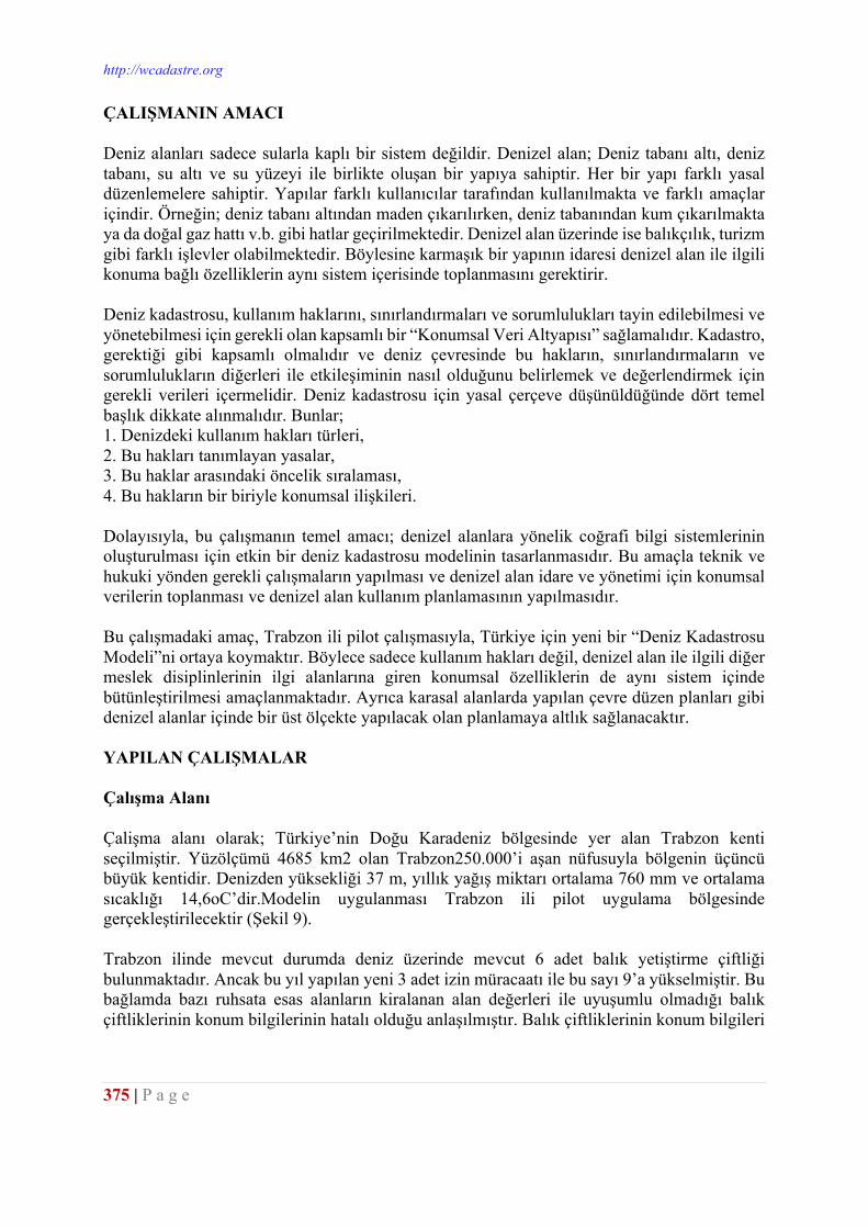
http://wcadastre.org
375 | P a g e
ÇALIŞMANIN AMACI Deniz alanları sadece sularla kaplı bir sistem değildir. Denizel alan; Deniz tabanı altı, deniz tabanı, su altı ve su yüzeyi ile birlikte oluşan bir yapıya sahiptir. Her bir yapı farklı yasal düzenlemelere sahiptir. Yapılar farklı kullanıcılar tarafından kullanılmakta ve farklı amaçlar içindir. Örneğin; deniz tabanı altından maden çıkarılırken, deniz tabanından kum çıkarılmakta ya da doğal gaz hattı v.b. gibi hatlar geçirilmektedir. Denizel alan üzerinde ise balıkçılık, turizm gibi farklı işlevler olabilmektedir. Böylesine karmaşık bir yapının idaresi denizel alan ile ilgili konuma bağlı özelliklerin aynı sistem içerisinde toplanmasını gerektirir. Deniz kadastrosu, kullanım haklarını, sınırlandırmaları ve sorumlulukları tayin edilebilmesi ve yönetebilmesi için gerekli olan kapsamlı bir “Konumsal Veri Altyapısı” sağlamalıdır. Kadastro, gerektiği gibi kapsamlı olmalıdır ve deniz çevresinde bu hakların, sınırlandırmaların ve sorumlulukların diğerleri ile etkileşiminin nasıl olduğunu belirlemek ve değerlendirmek için gerekli verileri içermelidir. Deniz kadastrosu için yasal çerçeve düşünüldüğünde dört temel başlık dikkate alınmalıdır. Bunlar; 1. Denizdeki kullanım hakları türleri, 2. Bu hakları tanımlayan yasalar, 3. Bu haklar arasındaki öncelik sıralaması, 4. Bu hakların bir biriyle konumsal ilişkileri. Dolayısıyla, bu çalışmanın temel amacı; denizel alanlara yönelik coğrafi bilgi sistemlerinin oluşturulması için etkin bir deniz kadastrosu modelinin tasarlanmasıdır. Bu amaçla teknik ve hukuki yönden gerekli çalışmaların yapılması ve denizel alan idare ve yönetimi için konumsal verilerin toplanması ve denizel alan kullanım planlamasının yapılmasıdır. Bu çalışmadaki amaç, Trabzon ili pilot çalışmasıyla, Türkiye için yeni bir “Deniz Kadastrosu Modeli”ni ortaya koymaktır. Böylece sadece kullanım hakları değil, denizel alan ile ilgili diğer meslek disiplinlerinin ilgi alanlarına giren konumsal özelliklerin de aynı sistem içinde bütünleştirilmesi amaçlanmaktadır. Ayrıca karasal alanlarda yapılan çevre düzen planları gibi denizel alanlar içinde bir üst ölçekte yapılacak olan planlamaya altlık sağlanacaktır. YAPILAN ÇALIŞMALAR Çalışma Alanı Çalişma alanı olarak; Türkiye’nin Doğu Karadeniz bölgesinde yer alan Trabzon kenti seçilmiştir. Yüzölçümü 4685 km2 olan Trabzon250.000’i aşan nüfusuyla bölgenin üçüncü büyük kentidir. Denizden yüksekliği 37 m, yıllık yağış miktarı ortalama 760 mm ve ortalama sıcaklığı 14,6oC’dir.Modelin uygulanması Trabzon ili pilot uygulama bölgesinde gerçekleştirilecektir (Şekil 9). Trabzon ilinde mevcut durumda deniz üzerinde mevcut 6 adet balık yetiştirme çiftliği bulunmaktadır. Ancak bu yıl yapılan yeni 3 adet izin müracaatı ile bu sayı 9’a yükselmiştir. Bu bağlamda bazı ruhsata esas alanların kiralanan alan değerleri ile uyuşumlu olmadığı balık çiftliklerinin konum bilgilerinin hatalı olduğu anlaşılmıştır. Balık çiftliklerinin konum bilgileri
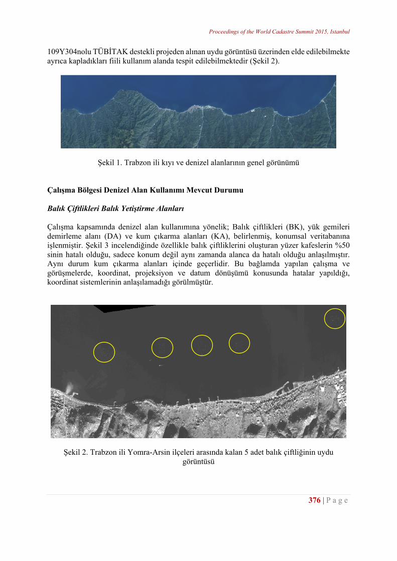
Proceedings of the World Cadastre Summit 2015, Istanbul
376 | P a g e
109Y304nolu TÜBİTAK destekli projeden alınan uydu görüntüsü üzerinden elde edilebilmekte ayrıca kapladıkları fiili kullanım alanda tespit edilebilmektedir (Şekil 2).
Şekil 1. Trabzon ili kıyı ve denizel alanlarının genel görünümü Çalışma Bölgesi Denizel Alan Kullanımı Mevcut Durumu Balık Çiftlikleri Balık Yetiştirme Alanları Çalışma kapsamında denizel alan kullanımına yönelik; Balık çiftlikleri (BK), yük gemileri demirleme alanı (DA) ve kum çıkarma alanları (KA), belirlenmiş, konumsal veritabanına işlenmiştir. Şekil 3 incelendiğinde özellikle balık çiftliklerini oluşturan yüzer kafeslerin %50 sinin hatalı olduğu, sadece konum değil aynı zamanda alanca da hatalı olduğu anlaşılmıştır. Aynı durum kum çıkarma alanları içinde geçerlidir. Bu bağlamda yapılan çalışma ve görüşmelerde, koordinat, projeksiyon ve datum dönüşümü konusunda hatalar yapıldığı, koordinat sistemlerinin anlaşılamadığı görülmüştür.
Şekil 2. Trabzon ili Yomra-Arsin ilçeleri arasında kalan 5 adet balık çiftliğinin uydu görüntüsü
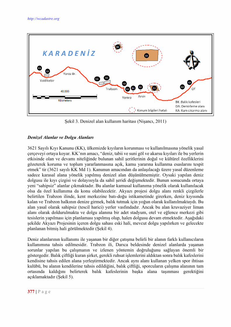
http://wcadastre.org
377 | P a g e
Şekil 3. Denizel alan kullanım haritası (Nişancı, 2011) Denizel Alanlar ve Dolgu Alanları 3621 Sayılı Kıyı Kanunu (KK), ülkemizde kıyıların korunması ve kullanılmasına yönelik yasal çerçeveyi ortaya koyar. KK’nın amacı, “deniz, tabii ve suni göl ve akarsu kıyıları ile bu yerlerin etkisinde olan ve devamı niteliğinde bulunan sahil şeritlerinin doğal ve kültürel özelliklerini gözeterek koruma ve toplum yararlanmasına açık, kamu yararına kullanma esaslarını tespit etmek” tir (3621 sayılı KK Md 1). Kanunun amacından da anlaşılacağı üzere yasal düzenleme sadece karasal alana yönelik yapılmış denizel alan düşünülmemiştir. Oysaki yapılan deniz dolgusu ile kıyı çizgisi ve dolayısıyla da sahil şeridi değişmektedir. Bunun sonucunda ortaya yeni “sahipsiz” alanlar çıkmaktadır. Bu alanlar kamusal kullanıma yönelik olarak kullanılacak olsa da özel kullanıma da konu olabilecektir. Akyazı projesi dolgu alanı renkli çizgilerle belirtilen Trabzon ilinde, kent merkezine batı-doğu istikametinde girerken, deniz kıyısında kalan ve Trabzon halkının denize girmek, balık tutmak için yoğun olarak kullanılmaktaydı. Bu alan yasal olarak sahipsiz (tescil harici) yerler vasfındadır. Ancak bu alan kruvaziyer liman alanı olarak doldurulmakta ve dolgu alanına bir adet stadyum, otel ve eğlence merkezi gibi tesislerin yapılması için planlaması yapılmış olup, halen dolgusu devam etmektedir. Aşağıdaki şekilde Akyazı Projesinin içeren dolgu sahası eski hali, mevcut dolgu yapılırken ve gelecekte planlanan bitmiş hali görülmektedir (Şekil 4). Deniz alanlarının kullanımı ile yaşanan bir diğer çatışma belirli bir alanın farklı kullanıcıların kullanımına tahsis edilmesidir. Trabzon ili, Darıca beldesinde denizel alanlarda yaşanan sorunlar yapılan bu çalışmanın ve izlenen yöntemin doğruluğunu sağlayan önemli bir göstergedir. Balık çiftliği kuran şirket, gerekli ruhsat işlemlerini aldıktan sonra balık kafeslerini kendisine tahsis edilen alana yerleştirmektedir. Ancak aynı alanı kullanan yelken spor ihtisas kulübü, bu alanın kendilerine tahsis edildiğini, balık çiftliği, sporcuların çalışma alanının tam ortasında kaldığını belirterek balık kafeslerinin başka alana taşınması gerektiğini açıklamaktadır (Şekil 5).
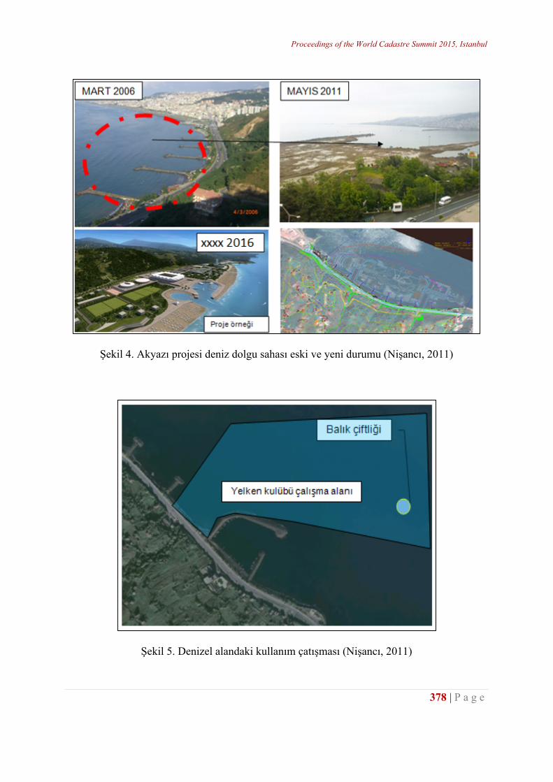
Proceedings of the World Cadastre Summit 2015, Istanbul
378 | P a g e
Şekil 4. Akyazı projesi deniz dolgu sahası eski ve yeni durumu (Nişancı, 2011)
Şekil 5. Denizel alandaki kullanım çatışması (Nişancı, 2011)
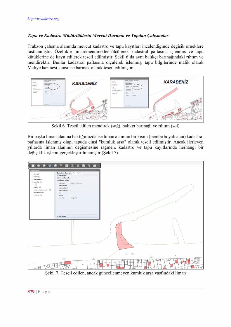
http://wcadastre.org
379 | P a g e
Tapu ve Kadastro Müdürlüklerin Mevcut Durumu ve Yapılan Çalışmalar Trabzon çalışma alanında mevcut kadastro ve tapu kayıtları incelendiğinde değişik örneklere rastlanmıştır. Özellikle liman/mendirekler ölçülerek kadastral paftasına işlenmiş ve tapu kütüklerine de kayıt edilerek tescil edilmiştir. Şekil 6’da aynı balıkçı barınağındaki rıhtım ve mendirektir. Bunlar kadastral paftasına ölçülerek işlenmiş, tapu bilgilerinde malik olarak Maliye hazinesi, cinsi ise barınak olarak tescil edilmiştir.
Şekil 6. Tescil edilen mendirek (sağ), balıkçı barınağı ve rıhtım (sol)
Bir başka liman alanına baktığımızda ise liman alanının bir kısmı (pembe boyalı alan) kadastral paftasına işlenmiş olup, tapuda cinsi "kumluk arsa" olarak tescil edilmiştir. Ancak ilerleyen yıllarda liman alanının değişmesine rağmen, kadastro ve tapu kayıtlarında herhangi bir değişiklik işlemi gerçekleştirilmemiştir (Şekil 7).
Şekil 7. Tescil edilen, ancak güncellenmeyen kumluk arsa vasfındaki liman
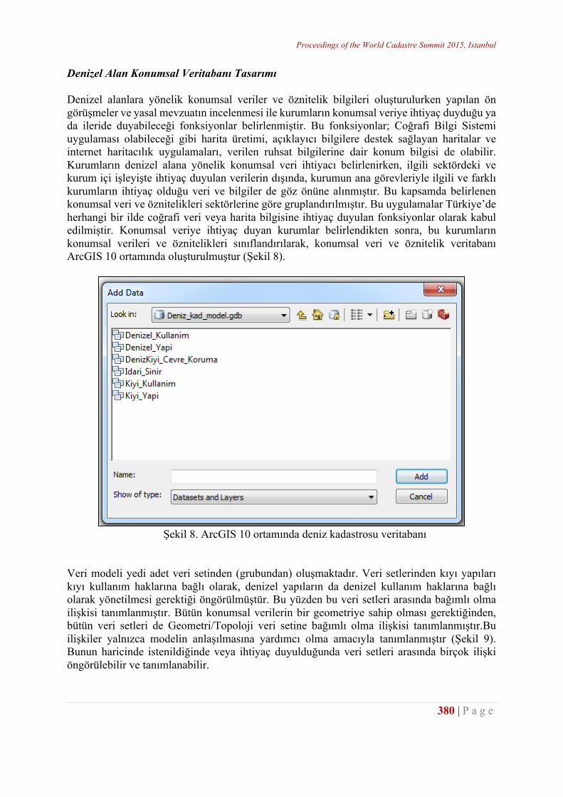
Proceedings of the World Cadastre Summit 2015, Istanbul
380 | P a g e
Denizel Alan Konumsal Veritabanı Tasarımı Denizel alanlara yönelik konumsal veriler ve öznitelik bilgileri oluşturulurken yapılan ön görüşmeler ve yasal mevzuatın incelenmesi ile kurumların konumsal veriye ihtiyaç duyduğu ya da ileride duyabileceği fonksiyonlar belirlenmiştir. Bu fonksiyonlar; Coğrafi Bilgi Sistemi uygulaması olabileceği gibi harita üretimi, açıklayıcı bilgilere destek sağlayan haritalar ve internet haritacılık uygulamaları, verilen ruhsat bilgilerine dair konum bilgisi de olabilir. Kurumların denizel alana yönelik konumsal veri ihtiyacı belirlenirken, ilgili sektördeki ve kurum içi işleyişte ihtiyaç duyulan verilerin dışında, kurumun ana görevleriyle ilgili ve farklı kurumların ihtiyaç olduğu veri ve bilgiler de göz önüne alınmıştır. Bu kapsamda belirlenen konumsal veri ve öznitelikleri sektörlerine göre gruplandırılmıştır. Bu uygulamalar Türkiye’de herhangi bir ilde coğrafi veri veya harita bilgisine ihtiyaç duyulan fonksiyonlar olarak kabul edilmiştir. Konumsal veriye ihtiyaç duyan kurumlar belirlendikten sonra, bu kurumların konumsal verileri ve öznitelikleri sınıflandırılarak, konumsal veri ve öznitelik veritabanı ArcGIS 10 ortamında oluşturulmuştur (Şekil 8).
Şekil 8. ArcGIS 10 ortamında deniz kadastrosu veritabanı
Veri modeli yedi adet veri setinden (grubundan) oluşmaktadır. Veri setlerinden kıyı yapıları kıyı kullanım haklarına bağlı olarak, denizel yapıların da denizel kullanım haklarına bağlı olarak yönetilmesi gerektiği öngörülmüştür. Bu yüzden bu veri setleri arasında bağımlı olma ilişkisi tanımlanmıştır. Bütün konumsal verilerin bir geometriye sahip olması gerektiğinden, bütün veri setleri de Geometri/Topoloji veri setine bağımlı olma ilişkisi tanımlanmıştır.Bu ilişkiler yalnızca modelin anlaşılmasına yardımcı olma amacıyla tanımlanmıştır (Şekil 9). Bunun haricinde istenildiğinde veya ihtiyaç duyulduğunda veri setleri arasında birçok ilişki öngörülebilir ve tanımlanabilir.
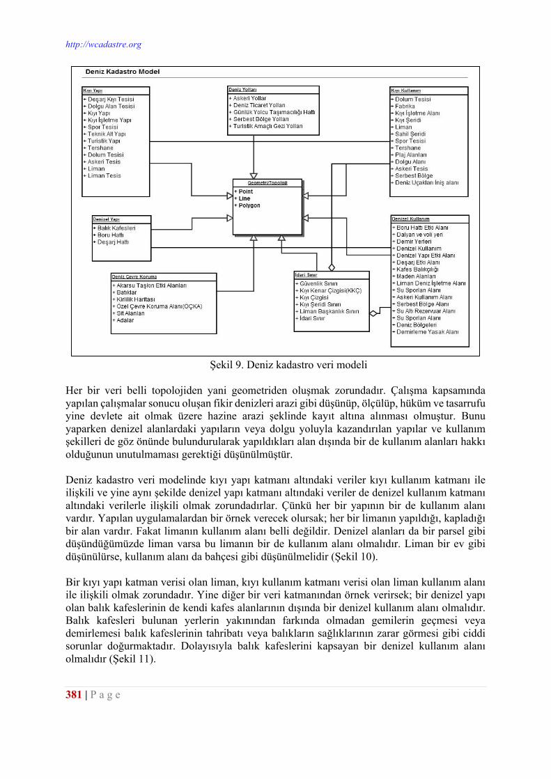
http://wcadastre.org
381 | P a g e
Şekil 9. Deniz kadastro veri modeli
Her bir veri belli topolojiden yani geometriden oluşmak zorundadır. Çalışma kapsamında yapılan çalışmalar sonucu oluşan fikir denizleri arazi gibi düşünüp, ölçülüp, hüküm ve tasarrufu yine devlete ait olmak üzere hazine arazi şeklinde kayıt altına alınması olmuştur. Bunu yaparken denizel alanlardaki yapıların veya dolgu yoluyla kazandırılan yapılar ve kullanım şekilleri de göz önünde bulundurularak yapıldıkları alan dışında bir de kullanım alanları hakkı olduğunun unutulmaması gerektiği düşünülmüştür. Deniz kadastro veri modelinde kıyı yapı katmanı altındaki veriler kıyı kullanım katmanı ile ilişkili ve yine aynı şekilde denizel yapı katmanı altındaki veriler de denizel kullanım katmanı altındaki verilerle ilişkili olmak zorundadırlar. Çünkü her bir yapının bir de kullanım alanı vardır. Yapılan uygulamalardan bir örnek verecek olursak; her bir limanın yapıldığı, kapladığı bir alan vardır. Fakat limanın kullanım alanı belli değildir. Denizel alanları da bir parsel gibi düşündüğümüzde liman varsa bu limanın bir de kullanım alanı olmalıdır. Liman bir ev gibi düşünülürse, kullanım alanı da bahçesi gibi düşünülmelidir (Şekil 10). Bir kıyı yapı katman verisi olan liman, kıyı kullanım katmanı verisi olan liman kullanım alanı ile ilişkili olmak zorundadır. Yine diğer bir veri katmanından örnek verirsek; bir denizel yapı olan balık kafeslerinin de kendi kafes alanlarının dışında bir denizel kullanım alanı olmalıdır. Balık kafesleri bulunan yerlerin yakınından farkında olmadan gemilerin geçmesi veya demirlemesi balık kafeslerinin tahribatı veya balıkların sağlıklarının zarar görmesi gibi ciddi sorunlar doğurmaktadır. Dolayısıyla balık kafeslerini kapsayan bir denizel kullanım alanı olmalıdır (Şekil 11).
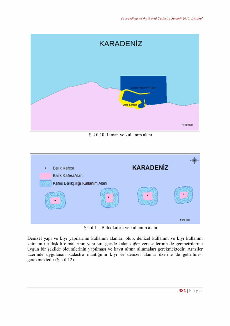
Proceedings of the World Cadastre Summit 2015, Istanbul
382 | P a g e
Şekil 10. Liman ve kullanım alanı
Şekil 11. Balık kafesi ve kullanım alanı
Denizel yapı ve kıyı yapılarının kullanım alanları olup, denizel kullanım ve kıyı kullanım katmanı ile ilişkili olmalarının yanı sıra geride kalan diğer veri setlerinin de geometrilerine uygun bir şekilde ölçümlerinin yapılması ve kayıt altına alınmaları gerekmektedir. Araziler üzerinde uygulanan kadastro mantığının kıyı ve denizel alanlar üzerine de getirilmesi gerekmektedir (Şekil 12).
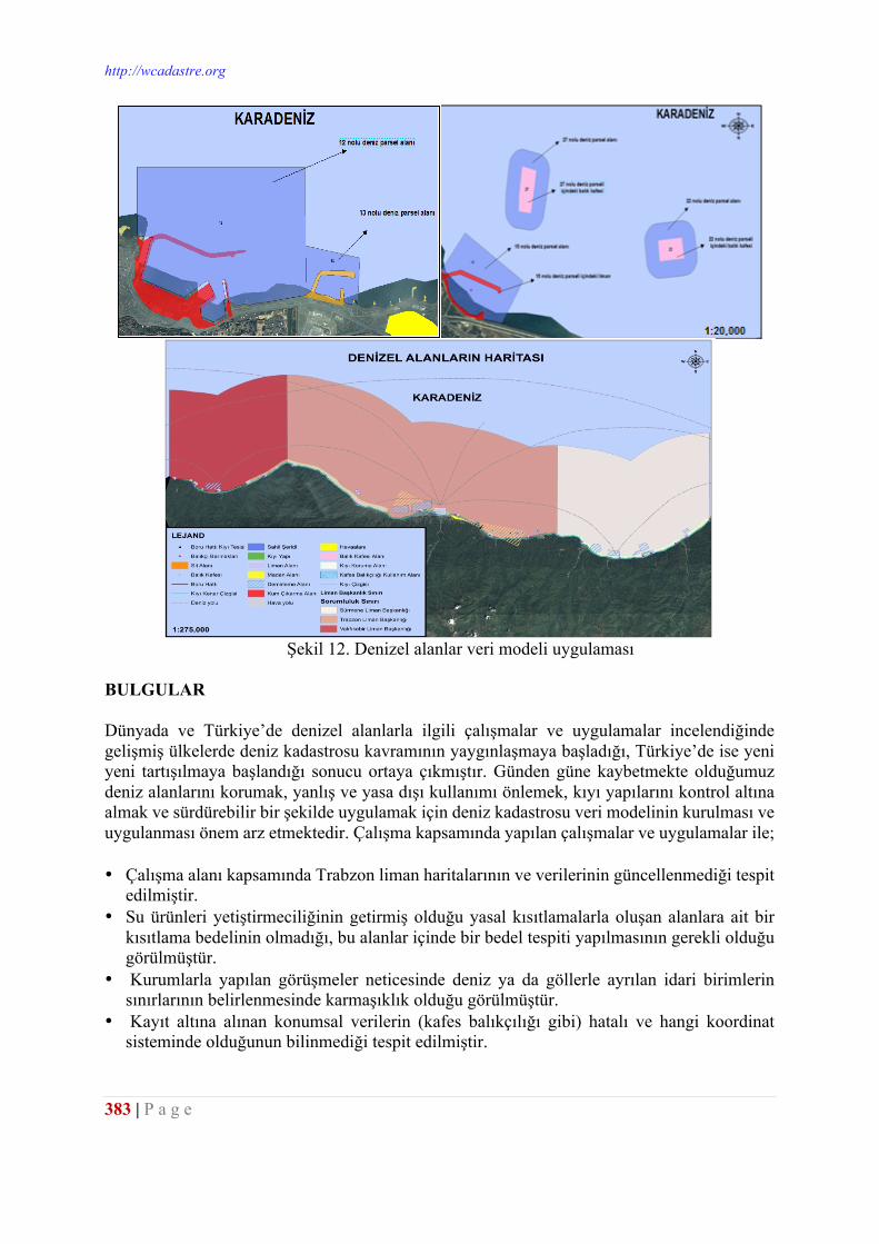
http://wcadastre.org
383 | P a g e
Şekil 12. Denizel alanlar veri modeli uygulaması
BULGULAR Dünyada ve Türkiye’de denizel alanlarla ilgili çalışmalar ve uygulamalar incelendiğinde gelişmiş ülkelerde deniz kadastrosu kavramının yaygınlaşmaya başladığı, Türkiye’de ise yeni yeni tartışılmaya başlandığı sonucu ortaya çıkmıştır. Günden güne kaybetmekte olduğumuz deniz alanlarını korumak, yanlış ve yasa dışı kullanımı önlemek, kıyı yapılarını kontrol altına almak ve sürdürebilir bir şekilde uygulamak için deniz kadastrosu veri modelinin kurulması ve uygulanması önem arz etmektedir. Çalışma kapsamında yapılan çalışmalar ve uygulamalar ile; • Çalışma alanı kapsamında Trabzon liman haritalarının ve verilerinin güncellenmediği tespit
edilmiştir. • Su ürünleri yetiştirmeciliğinin getirmiş olduğu yasal kısıtlamalarla oluşan alanlara ait bir
kısıtlama bedelinin olmadığı, bu alanlar içinde bir bedel tespiti yapılmasının gerekli olduğu görülmüştür.
• Kurumlarla yapılan görüşmeler neticesinde deniz ya da göllerle ayrılan idari birimlerin sınırlarının belirlenmesinde karmaşıklık olduğu görülmüştür.
• Kayıt altına alınan konumsal verilerin (kafes balıkçılığı gibi) hatalı ve hangi koordinat sisteminde olduğunun bilinmediği tespit edilmiştir.
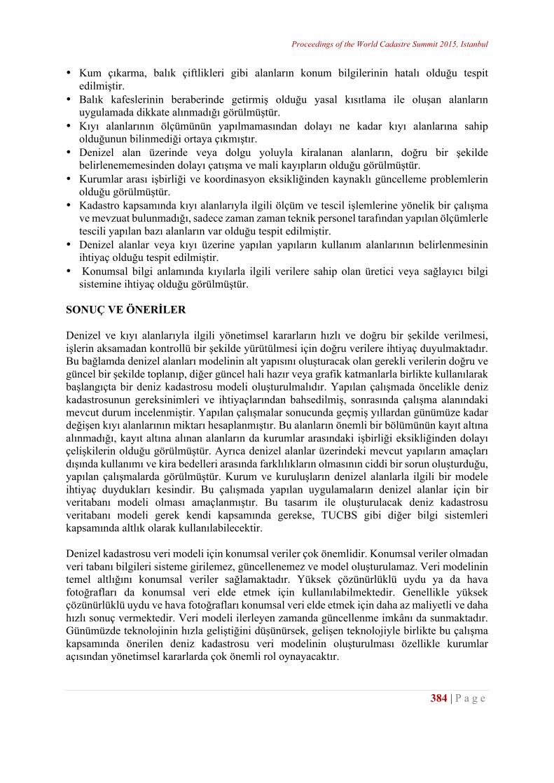
Proceedings of the World Cadastre Summit 2015, Istanbul
384 | P a g e
• Kum çıkarma, balık çiftlikleri gibi alanların konum bilgilerinin hatalı olduğu tespit edilmiştir.
• Balık kafeslerinin beraberinde getirmiş olduğu yasal kısıtlama ile oluşan alanların uygulamada dikkate alınmadığı görülmüştür.
• Kıyı alanlarının ölçümünün yapılmamasından dolayı ne kadar kıyı alanlarına sahip olduğunun bilinmediği ortaya çıkmıştır.
• Denizel alan üzerinde veya dolgu yoluyla kiralanan alanların, doğru bir şekilde belirlenememesinden dolayı çatışma ve mali kayıpların olduğu görülmüştür.
• Kurumlar arası işbirliği ve koordinasyon eksikliğinden kaynaklı güncelleme problemlerin olduğu görülmüştür.
• Kadastro kapsamında kıyı alanlarıyla ilgili ölçüm ve tescil işlemlerine yönelik bir çalışma ve mevzuat bulunmadığı, sadece zaman zaman teknik personel tarafından yapılan ölçümlerle tescili yapılan bazı alanların var olduğu tespit edilmiştir.
• Denizel alanlar veya kıyı üzerine yapılan yapıların kullanım alanlarının belirlenmesinin ihtiyaç olduğu tespit edilmiştir.
• Konumsal bilgi anlamında kıyılarla ilgili verilere sahip olan üretici veya sağlayıcı bilgi sistemine ihtiyaç olduğu görülmüştür.
SONUÇ VE ÖNERİLER Denizel ve kıyı alanlarıyla ilgili yönetimsel kararların hızlı ve doğru bir şekilde verilmesi, işlerin aksamadan kontrollü bir şekilde yürütülmesi için doğru verilere ihtiyaç duyulmaktadır. Bu bağlamda denizel alanları modelinin alt yapısını oluşturacak olan gerekli verilerin doğru ve güncel bir şekilde toplanıp, diğer güncel hali hazır veya grafik katmanlarla birlikte kullanılarak başlangıçta bir deniz kadastrosu modeli oluşturulmalıdır. Yapılan çalışmada öncelikle deniz kadastrosunun gereksinimleri ve ihtiyaçlarından bahsedilmiş, sonrasında çalışma alanındaki mevcut durum incelenmiştir. Yapılan çalışmalar sonucunda geçmiş yıllardan günümüze kadar değişen kıyı alanlarının miktarı hesaplanmıştır. Bu alanların önemli bir bölümünün kayıt altına alınmadığı, kayıt altına alınan alanların da kurumlar arasındaki işbirliği eksikliğinden dolayı çelişkilerin olduğu görülmüştür. Ayrıca denizel alanlar üzerindeki mevcut yapıların amaçları dışında kullanımı ve kira bedelleri arasında farklılıkların olmasının ciddi bir sorun oluşturduğu, yapılan çalışmalarda görülmüştür. Kurum ve kuruluşların denizel alanlarla ilgili bir modele ihtiyaç duydukları kesindir. Bu çalışmada yapılan uygulamaların denizel alanlar için bir veritabanı modeli olması amaçlanmıştır. Bu tasarım ile oluşturulacak deniz kadastrosu veritabanı modeli gerek kendi kapsamında gerekse, TUCBS gibi diğer bilgi sistemleri kapsamında altlık olarak kullanılabilecektir. Denizel kadastrosu veri modeli için konumsal veriler çok önemlidir. Konumsal veriler olmadan veri tabanı bilgileri sisteme girilemez, güncellenemez ve model oluşturulamaz. Veri modelinin temel altlığını konumsal veriler sağlamaktadır. Yüksek çözünürlüklü uydu ya da hava fotoğrafları da konumsal veri elde etmek için kullanılabilmektedir. Genellikle yüksek çözünürlüklü uydu ve hava fotoğrafları konumsal veri elde etmek için daha az maliyetli ve daha hızlı sonuç vermektedir. Veri modeli ilerleyen zamanda güncellenme imkânı da sunmaktadır. Günümüzde teknolojinin hızla geliştiğini düşünürsek, gelişen teknolojiyle birlikte bu çalışma kapsamında önerilen deniz kadastrosu veri modelinin oluşturulması özellikle kurumlar açısından yönetimsel kararlarda çok önemli rol oynayacaktır.
http://wcadastre.org
385 | P a g e
KAYNAKLAR Binns, A., Rajabifard, A., Collier, P. A. ve Williamson I., Developing the Concept of a Marine Cadastre:
An Australian Case Study, http://www.sli.unimelb.edu.au/maritime/publications/Binns%20et%20al%20 (2004) pdf, 20.01.2009.
CicinSain B., Robert W., vd., 1998. Integrated Coastland Ocean Management, Island Press, Washington. Collier, P. A., Leahy, F. J., and Williamson, I. P., 2001. Defining a Marine Cadastre for Australia, 42nd
Australian Surveyors Congress. Fraser, R., Todd, P. ve Collier, P., Issues in the Development of a Marine Cadastre,
http://www.gmat.unsw.edu.au/ablos/ABLOS03Folder/PAPER1-2.PDF, 20.01.2009. Fowler C. ve Treml E., 2001. Building a Marine Cadastral Information System For The United Stated – A
Case Study, Computers, Environment and Urban Systems, 25, 493507. Fulmer, J., 2007. The Multipurpose Marine Cadastre Web Map, 2007 ESRI Survey & Engineering GIS
Summit, June, San Diego, California. Levesque, S., Cockburn, S. ve Mcleay, C., 2010. Modern Developments in Geospatial Management in The
Field of Marine Cadastre, USA. Ng’ang’a, S., Sutherland, M. and Nichols, S., 2002. Data Integration and Visualisation Requirements for a
Canadian Marine Cadastre: Lessons from The Proposed Musquash Marine Protected Area, Symposium on Geospatial Theory, Processing and Applications, Ottawa, Canada.
Ng’ang’a, S., Nichols, S., Sutherland, M. ve Cockburn, S., 2001. Toward a Multidimensional Marine Cadastre in Support of Good Ocean Governance, International Conference on Spatial Information for Sustainable Development, Nairobi, Kenya.
Nişancı R., Uzun B., Demir O., Yıldırım V., Özçelik A.E., 2011. Denizel Alanlara Yönelik Kadastro Bilgi Sistemi Tasarımı: Trabzon Örneği, TMMOB Harita ve Kadastro Mühendisleri Odası 13. Türkiye Harita Bilimsel ve Teknik Kurultayı, Nisan, Ankara, Kurultay Cd.
Rajabifard, A., Collier, P. A. ve Williamson, I., 2003. Report on Australian Marine Cadastre Research and Activities, FIG and University of New Brunswick Meeting on Marine Cadastre Issues September, University of New Brunswick, Canada.
Robertson, B., Benwell, G. ve Hoogsteden, C., 1999. The Marine Resource: Administration Infrastructure Requirements, UN-FIG Conference on Land Tenureand Cadastral Infrastructures for Sustainable Development, October, Melbourne, Australia.
Sesli, F.A., Akyol, N. ve İnan, H.İ., 2002. Kıyı Alanlarında CBS ile Arazi Kullanım Vasfındaki Değişikliklerin Belirlenmesi, Türkiye’nin Kıyı ve Deniz Alanları IV. Ulusal Konferansı, İzmir.
Sesli, F. A. ve Çölkesen, İ., 2007. Türkiye’de Deniz Kadastrosu Gereksinimi Üzerine Bir Değerlendirme, TMMOB Harita ve Kadastro Mühendisleri Odası 11. Türkiye Harita Bilimsel ve Teknik Kurultayı, Ankara.
TÜBİTAK, 2012. Denizel Alan Coğrafi Bilgi Sistemleri İçin Deniz Kadastrosu Modellemesi (Proje Yürütücüsü: Doç. Dr. Recep NİŞANCI), TÜBİTAK CAYDAG 109Y304 Nolu Bilimsel ve Teknolojik Araştırma Projesi, Ankara.
UN 1982. United Nations Law of the Sea Convention, New York: UN. UN 1983. United Nations Law of the Sea Convention, New York: UN. Uslu G. ve Sesli F.A., 2011. Türkiye’de Deniz Kadastrosunun Önemi, TMMOB Harita ve Kadastro
Mühendisleri Odası 13. Türkiye Harita Bilimsel ve Teknik Kurultayı, Nisan, Ankara. Widodo, M. S., 2003. The Needs for Marine Cadastre and Supports of Spatial Data Infrastructures in
Marine Environment – A Case Study, FIG Working Week, April, Paris, France. Yomralıoğlu, T., Uzun, B. ve Demir, O., 2003. Kadastro 2014 Gelecekteki Kadastral Sistemler İçin Bir
Vizyon, TMMOB HKMO, Ankara, (Çeviri) Yomralıoğlu, T., 2000. Coğrafi Bilgi Sistemleri Temel Kavramlar ve Uygulamalar, 1. Baskı, Seçil Ofset. Yomralıoğlu T. "Coğrafi Bilgi Sistemleri: Temel Kavramlar ve Uygulamalar", 2000, ISBN: 975-97369-0-
X, İstanbul: İber Matbaası,5.Baskı. http://web.itu.edu.tr/tahsin/yayinlar/bookgis_dosyalar/bookgis.htm 15 Haziran 2012.
Proceedings of the World Cadastre Summit 2015, Istanbul
386 | P a g e
THE EVALUATION OF MARINE CADASTRE DEFINITIONS AMONG AUSTRALIA, CANADA AND UNITED STATES OF AMERICA BASED ON INDONESIA’S PERSPECTIVE AS AN
ARCHIPELAGIC STATE
Yackob Astor 1, Widyo Nugroho Sulasdi 2, S. Hendriatiningsih, MS 3, Dwi Wisayantono, MT 2
1 Geodesy and Geomatic Engineering Study Program, Faculty of Earth Sciences and
Technology, Bandung Institute of Technology (ITB), Indonesia - [email protected] 2 Coastal Zone Science and Engineering System Research Group, ITB, Indonesia.
3 Surveying and Cadastre Research Group, ITB, Indonesia. ABSTRACT In 1995 the International Federation of Surveyors (FIG) defined that “A Cadastre is normally a parcel-based and up-to-date land information system containing a record of interests in land (e.g. right, restrictions and responsibilities). It usually includes a geometric description of land parcels linked to other records describing the nature of the interests, the ownership or control of those interests, and often the value of the parcel and its improvements. It may be established for fiscal purposes (e.g. valuation and equitable taxation), legal purposes (conveyance), to assist in the management of land and land use (e.g. for planning and other administrative purposes), and enables sustainable development and environmental protection “. The above definition if it is implemented in Indonesia as an archipelagic state, so only 2.1 million km2 of natural resources (land based) as the object of cadastre. How about 5.8 million km2 of Indonesian marine resources? This research compared the marine resources management in some developed and non-island countries such as Australia, Canada and USA through the definition of marine cadastre which has been formulated in those countries. There is no marine cadastre definition especially for the archipelagic state up-to-now, the question is whether the marine cadastre definitions that existing in non-island countries can be implemented in Indonesian archipelago? The evaluation results which have been conducted showed that each existing marine cadastre definitions cannot be completely used in Indonesia. Therefore, it is needed to define an appropriate marine cadastre definition as the Unitary State of the Republic of Indonesia which the characteristics as archipelagic state. The marine cadastre definition must incorporate to the territorial coast competence elements in accordance with Act no.23 of 2014 based on Regional Government, Act no. 1 of 2014 on the management of Coastal Areas and Small Islands, and concerning to the existence of customary marine law recognized by the government. Keywords: marine cadastre definition, right, restriction, responsibility, archipelagic state. INTRODUCTION
http://wcadastre.org
387 | P a g e
The Unitary State of the Republic of Indonesia both in physical and geographical realities has the natural resources potential is much better than other countries. As a tropical country, Indonesia has fertilized land. It is surrounded by some unique species and some variety plants are biodiversity. The location of Indonesia lies along with the pacific track of the fire led to Indonesia is plenty of minerals, metals such as gold, silver, copper and nickel, coal, oil and geothermal energy are highly abundance. As an Indonesian islands (archipelagic state), It has oceanic territorial (6,120,673 km2, United Nations Environment Program 2003) wider than the land area (1,910,931.32 km2, The Ministry of Home Affair2010), approximately 13,466 islands (Geospatial Information Agency, 2013) along the coastline of 99,093 km (Geospatial Information Agency, 2013) makes Indonesia has greater marine resources than the natural resources on land. This marine resource conditions is seen as an opportunity for Indonesian developing country to build the excellent center in coastal and marine filed. Some problems that arise as Indonesian islands certainly cannot be separated from the conflict or problems that came out both domestics and overseas, the conflict among neighbors that related to territorial boundaries. Up-to-now, Indonesian marine setting boundaries among neighboring countries are still away from being resolved. Among ten countries that marine territorial boundaries, only Australia has been completed the marine boundaries to Indonesia. Meanwhile other neighboring countries are recently implemented to define the continental shelves limits and some partly marine territorial boundaries and also ZEE (Indonesia’s Exclusive Economic Zone). This condition frequently leads to claiming conflicts among the Indonesian and neighboring countries on marine territorial zone. As a result, it will appear instability and disrupt economic development in those territories. Under the 1945 constitution of the Republic of Indonesia Article 18 verse (1) The Unitary State of Republic of Indonesia shall be divided into provinces and those provinces shall be divided into regencies and municipalities, each of which shall have regional authorities which shall be regulated by law. Article 25 states that The Unitary State of the Republic of Indonesia is an archipelagic state, the boundaries and rights of whose territory shall be established by law. Both articles above declare that each province, district and municipal boundaries and their right must be defined by law. To determine the normatively boundaries that regulated in Act number 2 of 1999 amended Act number 32 of 2004 and then amended by Act number 23 of 2014 on Regional Government, and operationally set out in The Ministry of home Affair Regulation number 1 of 2006 amended The Ministry of Home Affair Regulation number 76 of 2012 on Guidelines Region Emphasis. Whereas, to determine the rights stipulated in Act number 27 of 2007 amended Act number 1 of 2014 on the Management of Coastal Territories and Small Islands. Issued Act number 32 of 2014 on Marine is one progress in marine resources management had been managed by sectorial laws and regional regulations. By the issued of Act number 32 of 2004, the central government gives some authorities to the Regional Government are not only limited to the government affairs, but also in terms of utilization and management of its wealthy resources including marine resources. This is confirmed that the Indonesian marine managed by some regional governments have the authority to the local marine territorial boundaries. The authority to manage all waters surrounding its islands to 12 nautical miles from the coastline to the open sea and / or in the direction of shores of the province and one third of the jurisdiction of the province to the districts/municipals.
Proceedings of the World Cadastre Summit 2015, Istanbul
388 | P a g e
The management of coastal and marine territories in Indonesian archipelago based on the regional autonomy system has a high degree of difficulty. It is because the given number of regencies /municipals in this state as many as 479 regencies / municipals, 324 regencies / municipals those have coastal areas (Ministry of Home Affairs, 2010). Each part of Indonesian coastal areas has different characteristics from other areas, so it has different ways to manage them. If that so, the policies and intuitional instruments are not the same. As a result, it will also effect on data provision management information of coastal and marine areas along with each region will be varied as well. The national marine resources are not only managed by local but also managed by sector. Based on the identifications result is shown that at least 12 ministries get involved in the resource marine management in Indonesia. This condition that occurred in these ministries for instance (the Ministry of Maritime Affairs and Fisheries, the Ministry of Energy and Mineral Resources, the Ministry of Environment, the Ministry of Transportation, the Ministry of Culture and Tourism, the Ministry of Commerce, the Ministry of Industry, the Ministry of Home Affairs, the Ministry of National Development Planning, the Ministry of Agriculture, the Ministry of Defence and Security, the Ministry of Public Works) has their own policies and regulation systems (not-integrated among each other’s). Their points of views and various management objectives and undirected well (without clear management and shared planning together among the ministries) cause the exploitation activities and marine areas functions (marine boundaries) are limited and overlapped among them. For example: marine parcels uses for fish farming overlapping with shipping lanes owing by revenues disruption in fish farming sector, or other example: the fishing areas uses for fishing overlapping with Navy space areas as a result the revenue disruption for fishermen in getting fishes. These uncertain conditions of marine boundary activities in the areas make some barriers among marine economic activities such as fisheries, aquacultures, biotechnology industries, marine tourisms, marine transportations, conservations, explorations and exploitations sectors. Based on cultural aspect, the Unitary State of the Republic of Indonesia as an archipelagic state has multicultural ethnicities. There are 10,640 villages (more than 14%) of village numbers in Indonesia (67,249 villages, the Board of Statistic Centre 2012)is a coastal village with an area of 35,949,021 hectare or 19% of the total area in Indonesian Villages. Approximately 92% of coastal villages in Eastern Indonesia are a traditional villagewho practiced natural resource management based on their own local custom (Grand Design of Rural Development, 2009). It is where the implementation of marine management in Eastern Indonesia is frequently confronted to the existence of customary marine management (customary marine law). The problems that occurred are the customary marine exclusivity territorial boundaries which determined based on their own implementation of custom regulations in their regions. For example, Haruku Island (the Rural Haruku) in Maluku province has its own customary boundaries among villages are determined based on an imaginary line that drawn from the land boundary straight out to sea, meanwhile to determine the limits between the limits of the village and communal marine pubic property or common property is by drawing imaginary line between the shallow and the deep seas. The impacts of customary marine delimitation are conflicting customary boundaries among the traditional villages, the rural sea customary boundary against outsiders and customary marine boundary against local marine authority
http://wcadastre.org
389 | P a g e
boundaries. Indigenous and local wisdom issues cannot be avoided due to they are being the part of cultural system in Indonesia. From the above discussion, it can be concluded that the implementation of marine management in Indonesia is strongly influenced by the regional autonomy system, the sectorial system and custom system, this condition is one of the implications as the consequences as an archipelagic state. Discussing on marine management resources in Indonesia, the first step in this research is to perform a comparison of marine resource management through marine cadastre definitions that exist in non-island developed countries such as Australia, Canada and United States. Marine cadastre can be regarded as the application of set principles of cadastre in sea area. Generally, the purpose of marine cadastre is to administer marine space and marine resources including all interests, rights, restrictions and responsibilities that exist in the marine territories. In 1999, the Australians Hoogsteden, Robertson, and Benwell defined the marine cadastre as follows “Marine cadastre is a system to enable the boundaries of maritime rights and interests to be recorded, spatially managed and physically defined in relationship to the boundaries of other neighboring or underlying rights and interests”. Then in 2004, Andre Binns defined that “Marine cadastre is a spatial boundary management tool which describes, visualizes and realizes legally defined boundaries and associated rights, restrictions, and responsibilities in the marine environment”. Marine cadastre in Australia used to create Australian’s Marine Management System which then used to regulate some activities such as oil and gas sector, fisheries, aquaculture, shipping, conservation, marine heritage, cable and pipelines, coastal zone. Australian marine cadastre concept has been implemented in several states such as Queensland and Victoria. In Canada, 2002 conducted good governance of Canada’s Oceans to resolve boundary issues as a first step to realize the effective marine management and fair. Nicholas, Monahan and Sutherland defined marine cadastre as follow “Marine cadastre is a marine information system, encompassing both the nature and a spatial extent of the interests and property rights, with respect to ownership and various rights and responsibilities in the marine jurisdiction. In 2002, United States Department of Communication (U.S DOC) - National Oceanic and Atmospheric Administration (NOAA) formulated the marine definition as follows “The U.S Marine cadastre is an information system, encompassing both nature and spatial extent of interests in property, value and use of marine areas. Marine or maritime boundaries share a common element with their land-based counterparts in that, in order to map a boundary, one must adequately interpret the relevant law and its spatial context. Marine boundaries are delimited, not demarcated, and generally there is no physical evidence of the boundary”. How about Indonesia as the largest archipelagic state in the world? The new concept of marine cadastre in Indonesia has been known for is still being introduced, in addition, since the past long the development in Indonesia is largely priority in land area, whereas as the archipelagic state, Indonesia has a wider marine area than the land area. Nevertheless there have been some researches in the field of management and coastal and marine spatial planning which relate to the element of cadastre, the right, restriction, and responsibility based on exploitation and utilization of oceanic spaces. However, from the previous marine cadastre studies that have
Proceedings of the World Cadastre Summit 2015, Istanbul
390 | P a g e
been conducted in Indonesia, they mostly used marine cadastre definition of non-island countries such as Australia, Canada, and United States of America. The existing marine cadastre definitions are internationally has been recognized by several countries around the globe. Giving the definition is very significant in a research or study. The definition defined as a statement that gives meaning to a word or phrase (Solomon, page 234). The definition is a phrase that expresses the meaning, description, or the main characteristics of the person, object, process or activity. As the main role of the definition is to provide limits (meaning), the scoop formulation and concept characteristics that became the subject or research. The importance of marine cadastre definitions in this study are the existing definitions of marine cadastre be used as an approach in building the concept model and marine management in Indonesian archipelago. This study will evaluate the definitions of existing marine cadastre in several non-island countries namely Australia, Canada and United States of America are placed in the Indonesian Perspective as an archipelagic State. METHODOLOGY To understand the concept and definition of the marine cadastre in each country, namely Australia, Canada and United States of America, the researcher conducted a literature study from various references so it is known the important things behind the marine cadastre definitions in those each non-island nations. An evaluation was conducted to the respective definitions of existing marine cadastre today, namely the definition of Australia (there are two definitions), Canada and United States of America. The evaluation conducted by the elements forming the marine cadastre definitions. And then, identifying and inventorying the key elements that forming the definitions, so it is known in common elements that exist in the four marine cadastre definitions. The similar elements then will be placed into the condition and utilization problems and the marine and coastal areas in Indonesia as an archipelagic state. LITERATURE REVIEWS The Marine Cadastre Definitions among non-Island Nations Marine Cadastre Definition from Australia (1999 and 2004): In 1999, Hoogsteden, Robertson and Benwell formulated the definition as follows: “Marine cadastre is a system to enable the boundaries of maritime rights and interests to be recorded, spatially managed and physically defined in relationship to the boundaries of the other neighboring or underlying rights and interests. The above definition has closely to the land cadastre definition, which is refers to the limits, in this case is a maritime boundary (boundaries of maritime). This definition is widely used by other countries, including United States of America (before formulating its own definition of the marine cadastre in 2002). The Australian Research Council (ARC) Marine Cadastre Project has used the marine cadastre definition as a starting point in the development of marine cadastre concept in Australia.
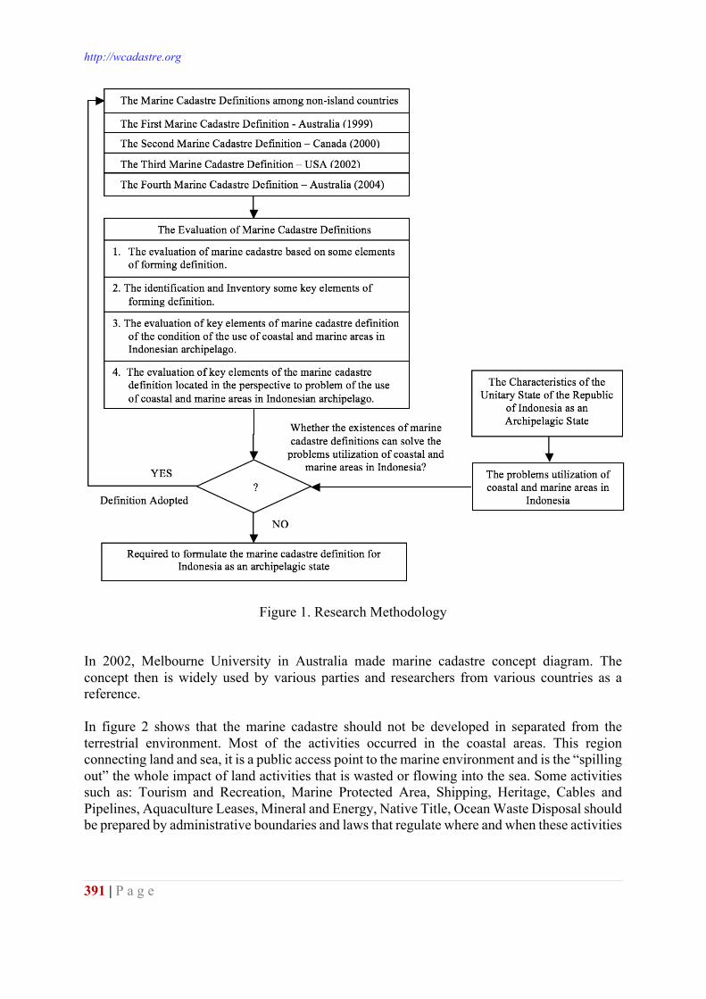
http://wcadastre.org
391 | P a g e
Figure 1. Research Methodology In 2002, Melbourne University in Australia made marine cadastre concept diagram. The concept then is widely used by various parties and researchers from various countries as a reference. In figure 2 shows that the marine cadastre should not be developed in separated from the terrestrial environment. Most of the activities occurred in the coastal areas. This region connecting land and sea, it is a public access point to the marine environment and is the “spilling out” the whole impact of land activities that is wasted or flowing into the sea. Some activities such as: Tourism and Recreation, Marine Protected Area, Shipping, Heritage, Cables and Pipelines, Aquaculture Leases, Mineral and Energy, Native Title, Ocean Waste Disposal should be prepared by administrative boundaries and laws that regulate where and when these activities
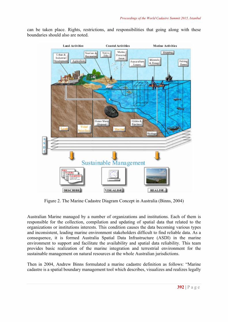
Proceedings of the World Cadastre Summit 2015, Istanbul
392 | P a g e
can be taken place. Rights, restrictions, and responsibilities that going along with these boundaries should also are noted.
Figure 2. The Marine Cadastre Diagram Concept in Australia (Binns, 2004) Australian Marine managed by a number of organizations and institutions. Each of them is responsible for the collection, compilation and updating of spatial data that related to the organizations or institutions interests. This condition causes the data becoming various types and inconsistent, leading marine environment stakeholders difficult to find reliable data. As a consequence, it is formed Australia Spatial Data Infrastructure (ASDI) in the marine environment to support and facilitate the availability and spatial data reliability. This team provides basic realization of the marine integration and terrestrial environment for the sustainable management on natural resources at the whole Australian jurisdictions. Then in 2004, Andrew Binns formulated a marine cadastre definition as follows: “Marine cadastre is a spatial boundary management tool which describes, visualizes and realizes legally
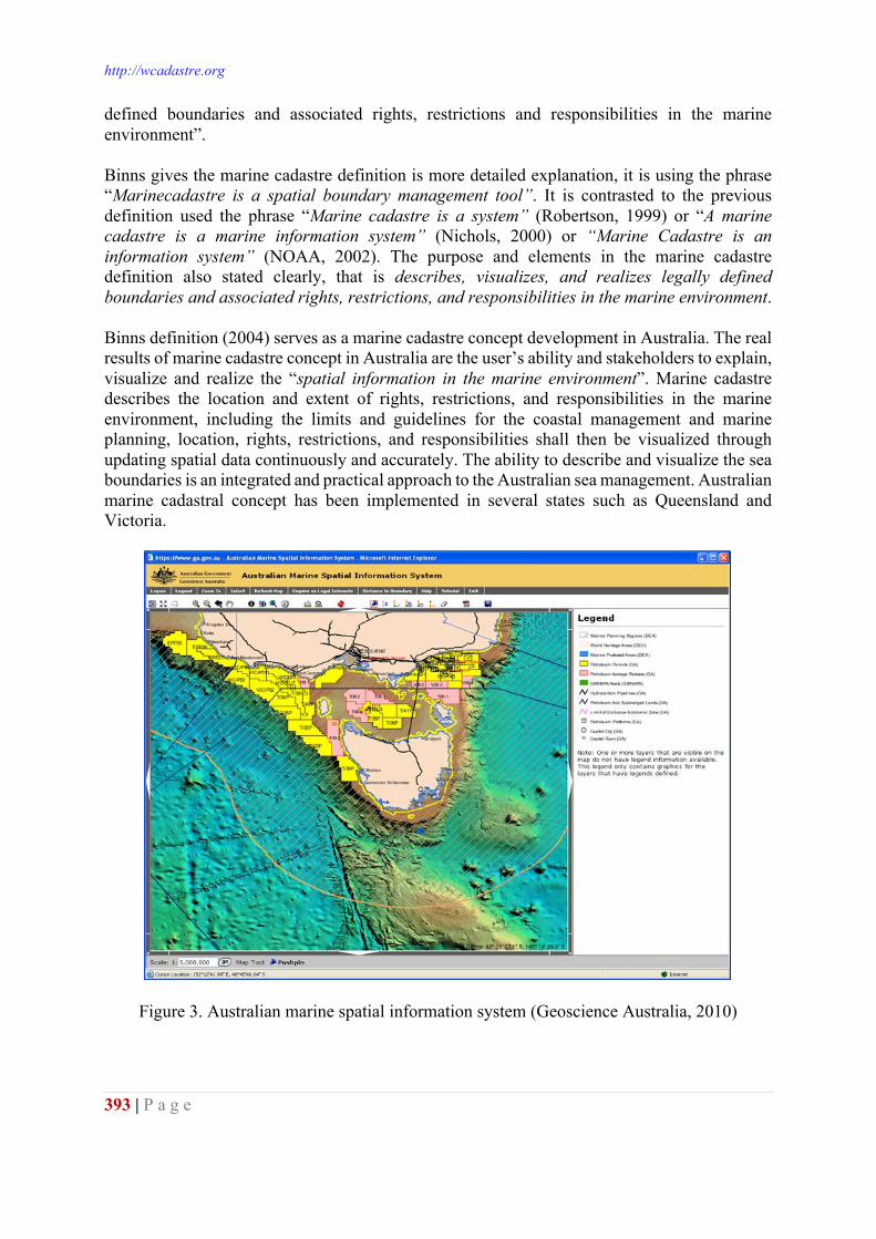
http://wcadastre.org
393 | P a g e
defined boundaries and associated rights, restrictions and responsibilities in the marine environment”. Binns gives the marine cadastre definition is more detailed explanation, it is using the phrase “Marinecadastre is a spatial boundary management tool”. It is contrasted to the previous definition used the phrase “Marine cadastre is a system” (Robertson, 1999) or “A marine cadastre is a marine information system” (Nichols, 2000) or “Marine Cadastre is an information system” (NOAA, 2002). The purpose and elements in the marine cadastre definition also stated clearly, that is describes, visualizes, and realizes legally defined boundaries and associated rights, restrictions, and responsibilities in the marine environment. Binns definition (2004) serves as a marine cadastre concept development in Australia. The real results of marine cadastre concept in Australia are the user’s ability and stakeholders to explain, visualize and realize the “spatial information in the marine environment”. Marine cadastre describes the location and extent of rights, restrictions, and responsibilities in the marine environment, including the limits and guidelines for the coastal management and marine planning, location, rights, restrictions, and responsibilities shall then be visualized through updating spatial data continuously and accurately. The ability to describe and visualize the sea boundaries is an integrated and practical approach to the Australian sea management. Australian marine cadastral concept has been implemented in several states such as Queensland and Victoria.
Figure 3. Australian marine spatial information system (Geoscience Australia, 2010)
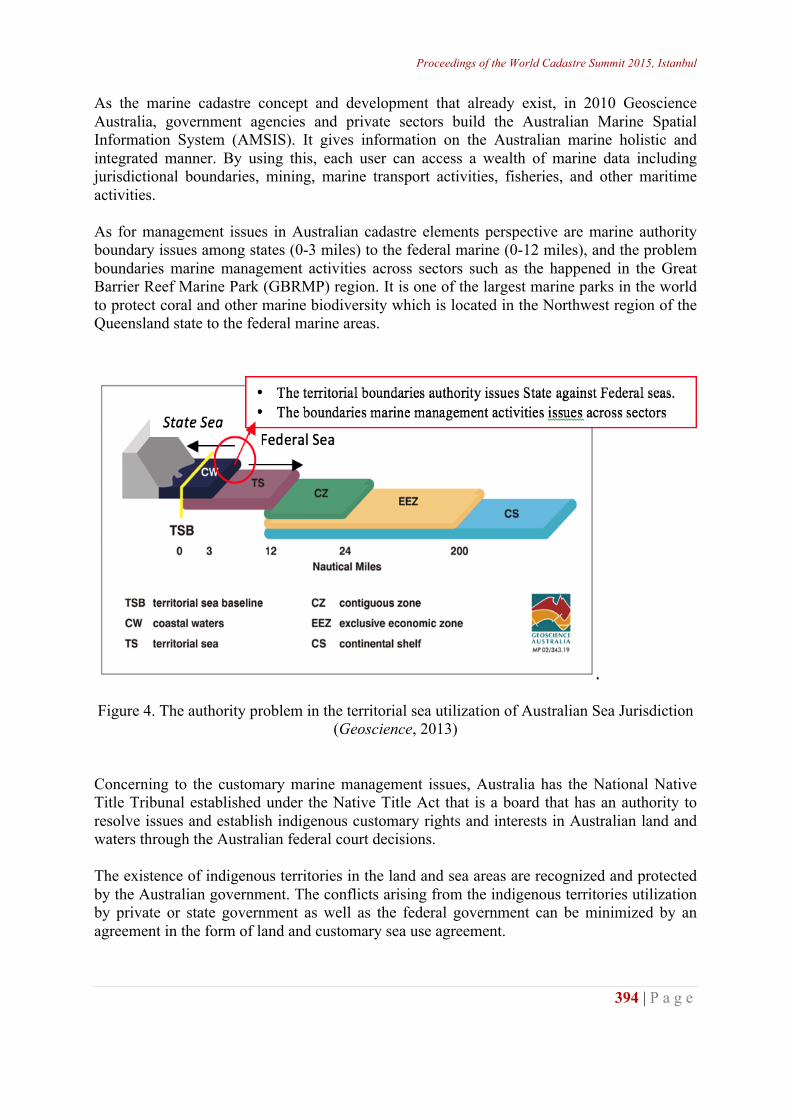
Proceedings of the World Cadastre Summit 2015, Istanbul
394 | P a g e
As the marine cadastre concept and development that already exist, in 2010 Geoscience Australia, government agencies and private sectors build the Australian Marine Spatial Information System (AMSIS). It gives information on the Australian marine holistic and integrated manner. By using this, each user can access a wealth of marine data including jurisdictional boundaries, mining, marine transport activities, fisheries, and other maritime activities. As for management issues in Australian cadastre elements perspective are marine authority boundary issues among states (0-3 miles) to the federal marine (0-12 miles), and the problem boundaries marine management activities across sectors such as the happened in the Great Barrier Reef Marine Park (GBRMP) region. It is one of the largest marine parks in the world to protect coral and other marine biodiversity which is located in the Northwest region of the Queensland state to the federal marine areas.
Figure 4. The authority problem in the territorial sea utilization of Australian Sea Jurisdiction
(Geoscience, 2013) Concerning to the customary marine management issues, Australia has the National Native Title Tribunal established under the Native Title Act that is a board that has an authority to resolve issues and establish indigenous customary rights and interests in Australian land and waters through the Australian federal court decisions. The existence of indigenous territories in the land and sea areas are recognized and protected by the Australian government. The conflicts arising from the indigenous territories utilization by private or state government as well as the federal government can be minimized by an agreement in the form of land and customary sea use agreement.
http://wcadastre.org
395 | P a g e
Table 1. The List of Territory Indigenous Land and Customary SeaUsed (up to March 32, 2013)
Marine Cadastre Definition from Canada (2000) Prior coming to 2000, Canada has defined Multipurpose Cadastre concept that linked law to fiscal cadastre and other spatial information to obtain broader spatial information related to the Geological and geophysical data, soils, vegetation, wildlife, hydrology, climate, pollution, health and safety, industry and employment, transport, water and sewerage, gas, electricity and telephone, emergency services. The implementation of multipurpose cadastre requires cooperation and integration among related institutions. It is realized by the establishment of Spatial Data Infrastructure (SDI) and Marine Geospatial Data Infrastructure as the part of Canadian Geospatial Data Infrastructure which regulated the need for laws, regulations and policies, governance structure, personal arrangements, data management and organization. The three dimensions marine cadastre concept are used to represent the rights and interest as the whole that occurred in the ocean, So making it easier to determine the rights and interests that exist at the water surface, water column, and subsoil of the bed. It includes the information related to legal tax, environmental and others. The information is then used to determine the laws, regulations and responsibilities of stakeholders. In 2000, the Canadian government conducted a research under the title: “Good Governance of Canada’s Ocean: The Use, Value and Potential of Marine Boundary Data”. The marine research focus is to consider the maritime boundaries issues and the marine boundaries activities. The purpose of this activity is to solve the boundary problem as a very beginning step to realize the effective marine management and fair. In order to achieve the objective requires an understanding of the interaction and spatial relationships among different boundaries types in the sea such as: the boundaries of private and public ownership, the cities, regencies, provinces and territorial jurisdiction and administrative boundaries, national and international, regional environmental protection, military boundaries, pipelines and subsea cables, and limit other activities. The maritime boundaries were identified and subsequently given an evaluation and visualization of each boundary, and then these boundaries serve as a conceptual framework for marine management in Canada.
Geospatial Services, National Native Title Tribunal - 11 April 2013
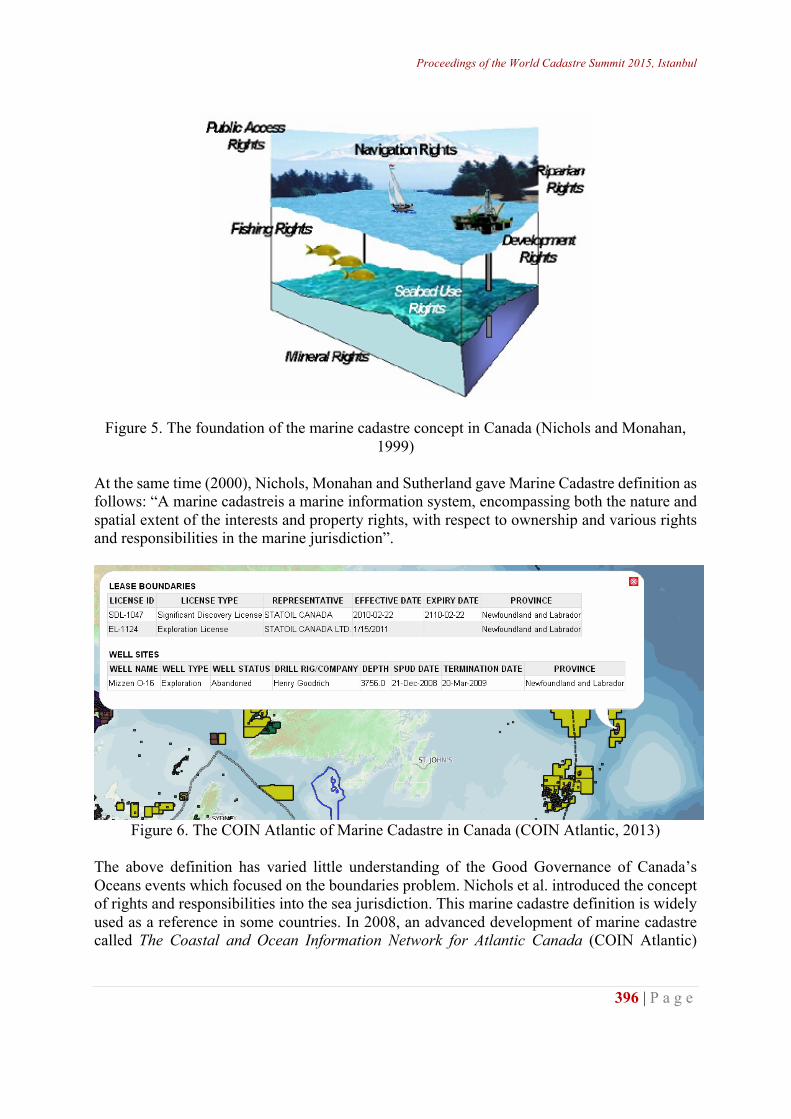
Proceedings of the World Cadastre Summit 2015, Istanbul
396 | P a g e
Figure 5. The foundation of the marine cadastre concept in Canada (Nichols and Monahan, 1999)
At the same time (2000), Nichols, Monahan and Sutherland gave Marine Cadastre definition as follows: “A marine cadastreis a marine information system, encompassing both the nature and spatial extent of the interests and property rights, with respect to ownership and various rights and responsibilities in the marine jurisdiction”.
Figure 6. The COIN Atlantic of Marine Cadastre in Canada (COIN Atlantic, 2013)
The above definition has varied little understanding of the Good Governance of Canada’s Oceans events which focused on the boundaries problem. Nichols et al. introduced the concept of rights and responsibilities into the sea jurisdiction. This marine cadastre definition is widely used as a reference in some countries. In 2008, an advanced development of marine cadastre called The Coastal and Ocean Information Network for Atlantic Canada (COIN Atlantic)
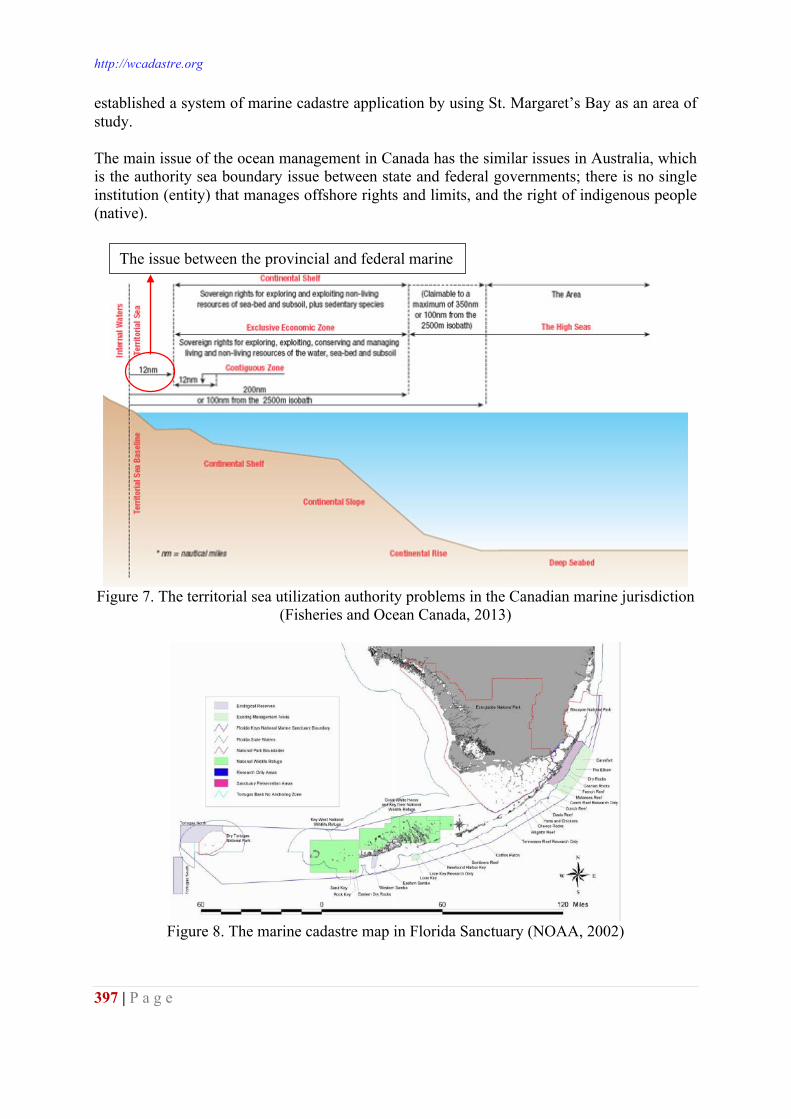
http://wcadastre.org
397 | P a g e
established a system of marine cadastre application by using St. Margaret’s Bay as an area of study. The main issue of the ocean management in Canada has the similar issues in Australia, which is the authority sea boundary issue between state and federal governments; there is no single institution (entity) that manages offshore rights and limits, and the right of indigenous people (native).
Figure 7. The territorial sea utilization authority problems in the Canadian marine jurisdiction
(Fisheries and Ocean Canada, 2013)
Figure 8. The marine cadastre map in Florida Sanctuary (NOAA, 2002)
The issue between the provincial and federal marine boundary
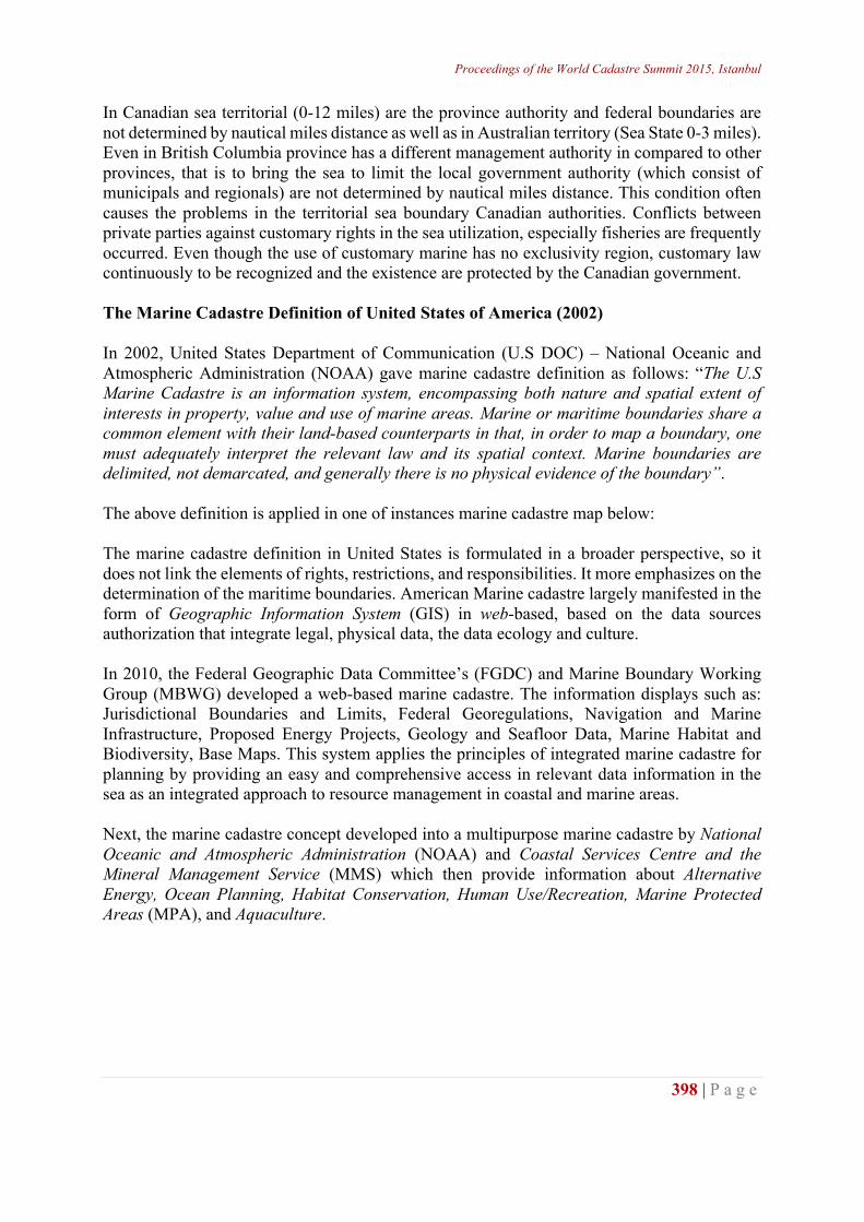
Proceedings of the World Cadastre Summit 2015, Istanbul
398 | P a g e
In Canadian sea territorial (0-12 miles) are the province authority and federal boundaries are not determined by nautical miles distance as well as in Australian territory (Sea State 0-3 miles). Even in British Columbia province has a different management authority in compared to other provinces, that is to bring the sea to limit the local government authority (which consist of municipals and regionals) are not determined by nautical miles distance. This condition often causes the problems in the territorial sea boundary Canadian authorities. Conflicts between private parties against customary rights in the sea utilization, especially fisheries are frequently occurred. Even though the use of customary marine has no exclusivity region, customary law continuously to be recognized and the existence are protected by the Canadian government. The Marine Cadastre Definition of United States of America (2002) In 2002, United States Department of Communication (U.S DOC) – National Oceanic and Atmospheric Administration (NOAA) gave marine cadastre definition as follows: “The U.S Marine Cadastre is an information system, encompassing both nature and spatial extent of interests in property, value and use of marine areas. Marine or maritime boundaries share a common element with their land-based counterparts in that, in order to map a boundary, one must adequately interpret the relevant law and its spatial context. Marine boundaries are delimited, not demarcated, and generally there is no physical evidence of the boundary”. The above definition is applied in one of instances marine cadastre map below: The marine cadastre definition in United States is formulated in a broader perspective, so it does not link the elements of rights, restrictions, and responsibilities. It more emphasizes on the determination of the maritime boundaries. American Marine cadastre largely manifested in the form of Geographic Information System (GIS) in web-based, based on the data sources authorization that integrate legal, physical data, the data ecology and culture. In 2010, the Federal Geographic Data Committee’s (FGDC) and Marine Boundary Working Group (MBWG) developed a web-based marine cadastre. The information displays such as: Jurisdictional Boundaries and Limits, Federal Georegulations, Navigation and Marine Infrastructure, Proposed Energy Projects, Geology and Seafloor Data, Marine Habitat and Biodiversity, Base Maps. This system applies the principles of integrated marine cadastre for planning by providing an easy and comprehensive access in relevant data information in the sea as an integrated approach to resource management in coastal and marine areas. Next, the marine cadastre concept developed into a multipurpose marine cadastre by National Oceanic and Atmospheric Administration (NOAA) and Coastal Services Centre and the Mineral Management Service (MMS) which then provide information about Alternative Energy, Ocean Planning, Habitat Conservation, Human Use/Recreation, Marine Protected Areas (MPA), and Aquaculture.
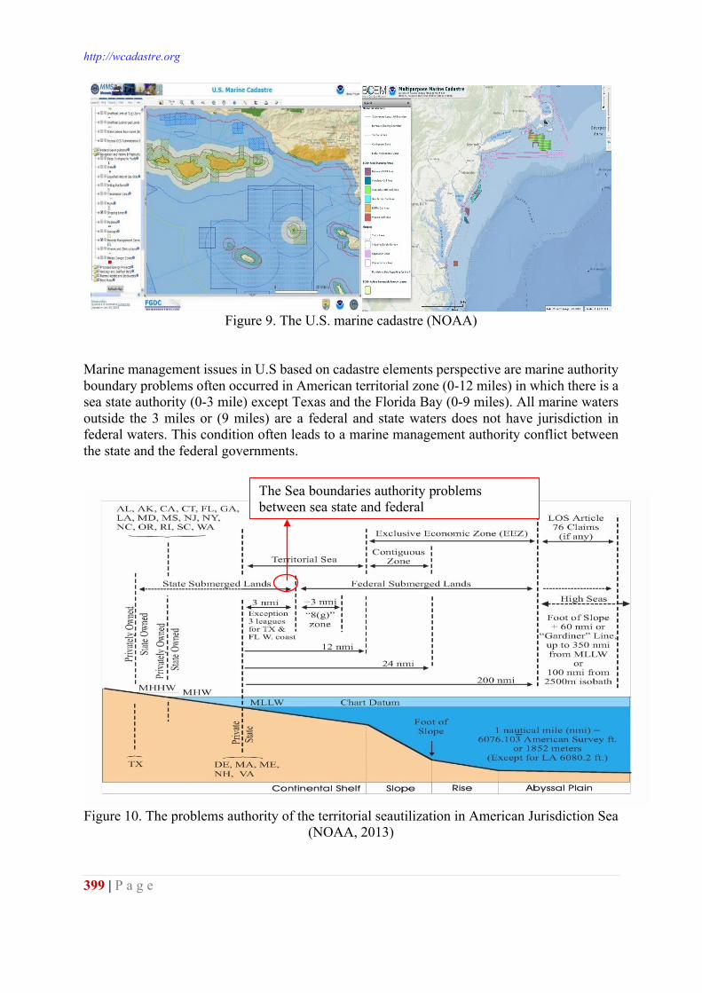
http://wcadastre.org
399 | P a g e
Figure 9. The U.S. marine cadastre (NOAA)
Marine management issues in U.S based on cadastre elements perspective are marine authority boundary problems often occurred in American territorial zone (0-12 miles) in which there is a sea state authority (0-3 mile) except Texas and the Florida Bay (0-9 miles). All marine waters outside the 3 miles or (9 miles) are a federal and state waters does not have jurisdiction in federal waters. This condition often leads to a marine management authority conflict between the state and the federal governments.
Figure 10. The problems authority of the territorial seautilization in American Jurisdiction Sea
(NOAA, 2013)
The Sea boundaries authority problems between sea state and federal
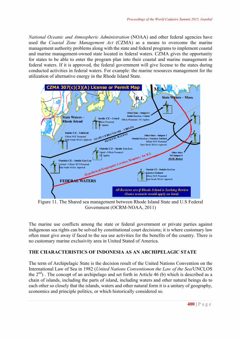
Proceedings of the World Cadastre Summit 2015, Istanbul
400 | P a g e
National Oceanic and Atmospheric Administration (NOAA) and other federal agencies have used the Coastal Zone Management Act (CZMA) as a means to overcome the marine management authority problems along with the state and federal programs to implement coastal and marine management-owned state located in federal waters. CZMA gives the opportunity for states to be able to enter the program plan into their coastal and marine management in federal waters. If it is approved, the federal government will give license to the states during conducted activities in federal waters. For example: the marine resources management for the utilization of alternative energy in the Rhode Island State.
Figure 11. The Shared sea management between Rhode Island State and U.S Federal
Government (OCRM-NOAA, 2011) The marine use conflicts among the state or federal government or private parties against indigenous sea rights can be solved by constitutional court decisions; it is where customary law often must give away if faced to the sea use activities for the benefits of the country. There is no customary marine exclusivity area in United Stated of America. THE CHARACTERISTICS OF INDONESIA AS AN ARCHIPELAGIC STATE The term of Archipelagic State is the decision result of the United Nations Convention on the International Law of Sea in 1982 (United Nations Conventionon the Law of the Sea/UNCLOS the 2nd) . The concept of an archipelago and set forth in Article 46 (b) which is described as a chain of islands, including the parts of island, including waters and other natural beings do to each other so closely that the islands, waters and other natural form it is a unitary of geography, economics and principle politics, or which historically considered so.
http://wcadastre.org
401 | P a g e
The Nation Conception is based upon the archipelago conception of islands which means the sea where there are many islands. In the archipelago term of the sea or water ratio is greater than the mainland (islands), but both of them are considered as a whole. Thus, the most important interpretation in the archipelago concept is unitary between the sea and the land (and the air above them), where the ration of the sea area is greater than the ration of land area (Djalal, 1979). The geographical conception becomes the basic for the conception of archipelagic state that consisted of one or more archipelagoes, meanwhile not every archipelago classified into archipelagic state or not to be treated as an archipelagic state. Therefore, there are three types of the archipelagoes, namely:
1. Coastal Archipelago, which is located along the coast and is generally adjacent to the seashore. It is basically completed by the Geneva Conference in 1958 on the seashore area that allows states draw the basic lines of the archipelago which lies adjacent along the coast.
2. Mid-ocean Archipelago, which is located in the middle of the sea off the coast of a country. Basically the International Law Conception concerning archipelago comes from the term archipelago-archipelago, which generally is an islands cluster that is compact and the distance between the islands is not so wide.
3. Archipelagic state, which is an islands cluster or several clusters of islands, became an independent state.
Based on the above explanations that the State island (Archipelagic State) is a country that is supposed to be composed of one or more islands may include other islands. An archipelago will be considered as a single entity, so that the waters around, surrounding, and connecting the islands (apart from the vast and different dimensions) are the part of internal waters of the state. Forming an island country is determined based upon the archipelagic straight baseline determination and the other baselines as long as not contrary to the 1982 Convention (Article 5, 7 (1) and 47 (1)). None of countries are geographically islands can establish by itself as an archipelagic state legally. At least, there are five sovereign states that obtained an approval in the United Nations Convention on United Nations Convention on the Law of the Sea (UNCLOS) and qualify as the Archipelagic Nations: Indonesia, Philippines, Papua New Guinea, Fuji and the Bahamas. These five Islands countries have to respect the agreement to other countries and should recognize the traditional fishing rights and other legitimate activities of neighbouring countries that directly bordered in certain areas in the same waters of the archipelago. The terms and conditions for the realization of the rights and further activities are regulated by bilateral agreements between the countries. In Djuanda Declaration, Indonesian government confirms an Archipelagic State principle which viewed at the sea and land areas as a unified as a whole in accordance with motherland philosophy. The Article 46 provisions of the Convention on the Law of the Sea in 1982 if it is linked to the reality in Indonesian characteristics as an archipelagic state, shows that the islands of Unitary State of the Republic of Indonesia are provincial area with some characteristics of:
Proceedings of the World Cadastre Summit 2015, Istanbul
402 | P a g e
1. Coastal archipelago, it means provincial areas which have islands along with the main seashore, for example: the Jakarta Province, North Sumatra Province, West Sumatra Province, Riau Province, the Papua Province, West Papua Province and other provinces.
2. Mid-ocean archipelago, it means provincial areas which have islands in the middle of the sea as the part of the regional territory, for example: East Java Province, South Sulawesi Province, Southeast Sulawesi Province and other provinces.
3. Archipelagic Province or it is called the Region Islands province which areas have the islands that chain of islands shaped; such as Riau Islands Province, Bangka Belitung Islands Province, West Nusa Tenggara Province, East Nusa Tenggara Province, North Sulawesi Province, North Maluku Province and Maluku Islands Province.
Furthermore, as the essence of archipelagic state are a unified as a whole territory (land space, sea space, and air space) which boundaries are determined by the sea and inside it there are islands and an islands cluster. The naming of the Unitary State of the Republic Indonesia as the country still need to be added to the islands of the archipelago characterized, it is accordance to what is written in the 1945 constitution, Article 25. It is characterized archipelago or commonly known as the Archipelago Concept which is archipelagic islands as a single political will, economics, social, cultural, defense and security (SULASDI, 2010). Based on the above explanation, it is stated that the Unitary State of the Republic of Indonesia is an archipelagic state has a functional model as follows: (Sovereignty, Geographical Spatial Planning, Governance, Multicultural, Biodiversity, Disaster Prone, Defense and Security).
1. Sovereignty = (internal waters, archipelagic waters, territorial sea, air space over the territorial sea, the air space over the archipelagic waters, the air space above the waters, seabed, underwater land and natural resources)
2. Spatial Geographic = (land, coastal areas, oceanic areas islands, islands, cays and islands).
3. Governance = (central government, provincial governments, local government, municipal government, and regional government)
4. Multicultural nationality (tribe, language, religion, culture or customs) 5. Natural resources in biodiversity = (renewable resources, non-renewable resources,
space and region resources, and geographical location). 6. Disaster Risks = (geography of the specific location, types of disasters, the impact or
risk mitigation). 7. Defense and Security = (airspace, land space, sea areas and islands).
ANALYSIS AND DISCUSSION The Evaluation of Marine Cadastre Definitions Based on Elements Definition Shaped Based on the identification and inventory of the key elements of the four marine cadastre definitions above, the next step is to perform a classification based on the similarity of the key elements in order to obtain the nine results of key elements of the marine cadastre as follows: Right, Restriction, Responsibility, Interest, Marine boundaries, the geodetic reference system, The use of marine areas, Marine jurisdiction, and Institution.
http://wcadastre.org
403 | P a g e
The Key Elements Evaluation of Marine Cadastre Definition to the Utilization Conditions Coastal and Marine in Indonesia as an Archipelagic State The key elements of the marine cadastre placed in utilization conditions of coastal and marine areas in the waters of Strait Madura East Java Province represents the western part of Indonesia and the waters in Maluku Province represents the eastern part of Indonesia. The organizing the utilization of coastal and marine areas in its western part has a higher level of complexity rather than in its eastern part, it is proven by the number of sectors get involved in the implementation and utilization of marine diversity conflicts among the sectors and the regions, such as occurred in St. Madura East Java. In contrast to the conditions and problems in the western part of Indonesia, the implementation of sea usage in eastern Indonesia is often confronted to the existence of customary sea management. Maluku Province has an area of 527,191 km2 and vest seashore 54,185 km2, which consisted of 559 cays islands (Moluccas in Figure, 2011) Maluku Province as the largest archipelago in Indonesia has many found the existence of indigenous people who use the local customary based archipelagic waters. In Maluku Province, fisheries management practices based on the local wisdom has been long known as petuanan and sasi. Table 2. The evaluation of marine cadastre definitions based on the elements forming the definition No Country Marine Cadastre
Definition The Elements of Forming Definition
The Explanation of Definition
1 Australia Marine cadastre is a system to enable the boundaries of maritime rights and interests to be recorded, spatially managed and physically defined in relationship to the boundaries of other neighboring or underlying rights and interests. (Hoogsteden, Robertson and Benwell, 1999)
1.System 2.Boundaries of Maritime 3.Rights 4.Interests 5.Recorded 6.Spatially managed 7.Physically defined 8.Relationship the boundaries 9. Neighboring 10.Underlying
• Marine cadastre is defined as a system. • This definition contains the concept of local autonomy in natural resource management perspective. • This definition is more focused on the recording, the definition, management and the relationship among the limits in the sea. • The only one (from 4 definitions) that does not mention the legal elements of the sea.
2 Canada A marine cadastre is a marine information system, encompassing both the nature and spatial extent of the interests and property rights, with respect to ownership, various rights and responsibilities in the marine jurisdiction. (Nichols, Monahan and Sutherland, 2000).
1.Marine information system 2.Nature 3.Spatial extent 4.Interests 5.Property rights 6.Ownership 7.Various rights 8.Responsibilities 9.Marine Jurisdiction
• Marine cadastre is defined as a system of marine information. • This definition introduces the concept of the rights associated with ownership of the sea. •
Proceedings of the World Cadastre Summit 2015, Istanbul
404 | P a g e
3 United States of America
The U.S. Marine Cadastre is an information system, encompassing both nature and spatial extent of interests in property, value and use of marine areas. Marine or maritime boundaries share a common element with their land-based counterparts in that, in order to map a boundary, one must adequately interpret the relevant law and its spatial context. Marine boundaries are delimited, not demarcated, and generally there is no physical evidence of the boundary.(NOAA, 2002).
1.Information system 2.Nature 3.Spatial extent 4.Interests 5.Property 6.Value 7.Use marine areas 8.Marine boundaries 9.A common element 10. Land 11.Based counterparts 12.Map a boundary 13.Adequately interpret 14.Relevant law 15.Spatial context 16.Delimited 17.Not demarcated 18.No physical evidence
• Marine cadastre is still defined as a system. This definition has little resemblance to the definition of Canada, but it is more focused on defining of the marine boundaries. • This definition contains the concept of the rule of law to resolve conflicts at sea activities. • This definition does not completely mention the cadastre elements (rights, restriction, and responsibilities).
4 Australia Marine cadastre is a spatial boundary management tool which describes, visualizes and realizes legally defined boundaries and associated rights, restrictions and responsibilities in marine environment. (Binns, 2004).
1.Spatial boundary 2.Management 3.Tool 4.Describes 5. Visualizes 6. Realizes 7.Legally defined 8.Boundaries 9.Associated 10.Rights 11.Restrictions 12.Respinsibilities 13.Marine environment
• Marine cadastre is no longer be called a system, but rather than as a tool. • This definition contains the concept of cross-sectorial activities in the national perspective.
The Identification and Inventory of Key Elements in Forming Definition Table 3. The identification and inventory of the key elements of the marine cadastre definition
The key elements of the marine cadastre definition The first Definition (Australia, 1999)
The Second Definition (Canada, 2000)
The Third Definition (United States of America, 2002)
The fourth Definition (Australia, 2004)
1.System 1.Marine information system
1. Information system 1. Management tool
2.Marine boundaries: a. The sea boundary adjacent b. The sea boundary underlying rights or interests
2. 2.a. Marine boundaries b. Boundary map c. Boundary mark
2.Boundaries
3.Rights 3.a. Property rights b. Ownership rights
3. 3. Rights
http://wcadastre.org
405 | P a g e
c. Various rights 4. 4.Responsibilities 4. 4.Responsibilities 5. 5. 5. 5.Restrictions 6. Interests 6. Interests 6. Interests 6. 7.Recorded 7. 7. 7.a. Describes
b. Visualizes c. Realizes
8.Spatially and physically managed
8.Nature and spatial extents
8.Nature and spatial extents
8.Spatial boundary
9. 9.Marine jurisdiction areas 9.Relevant laws 9.Legally 10. 10. 10.Value and use of
marine areas 10.Marine environment
Table 4. The evaluation of the key elements of marine cadastre definition to the condition use of coastal and marine areas in Indonesia as an archipelagic state The key elements of marine cadastre definitions
The marine cadastre definition in non-island countries The Unitary State of the Republic of Indonesia as an archipelagic state
A 1st Definition Australia, 1999
B 2nd Definition Canada, 2000
C 3rd Definition USA, 2002
D 4th Definition Australia, 2004
West regional section (Strait Madura, East Java)
East regional section (Waters in Maluku Province)
1. Right 1.Oil and gas development rights. 2. Traditional fishing rights. 3.Aboriginal rights 4.Coastal property rights (including riparian rights): rights for public navigation, recreation, and access.
1.Public access rights. 2.Navigation rights. 3.Riparian rights. 4.Fishing rights. 5.Development rights. 6.Mineral rights. 7.Seabed use rights.
1.Public access rights. 2.Navigation rights. 3.Riparian rights. 4.Fishing rights. 5.Development rights. 6.Mineral rights. 7.Seabed use rights.
1.Oil and gas development rights. 2.Traditional fishing rights. 3.Aboriginal rights 4.Coastal property rights (including riparian rights): rights for public navigation, recreation, and access.
-1A1, 1D1 -1A2, 1D2 -1A4, 1D4 -1B1, 1C1 -1B2, 1C2 -1B4, IC4 -1B6, 1C6 -1B7, 1C7
-1A3, 1D3
2. Restriction
Based on the Federal Waters, State Waters, and concerning Native Rights
Based on the Federal Waters, Provincial Waters, Local Government Waters and concerning Native Rights.
Based on the Federal Waters and State Waters
Based on the Federal Waters, State Waters, and concerning Native Rights
2B 2B
3. Responsibility
Under federal law, the states and customs.
Under federal law, provincial, local
Under federal law and states law.
Under federal law and states law.
3B 3B
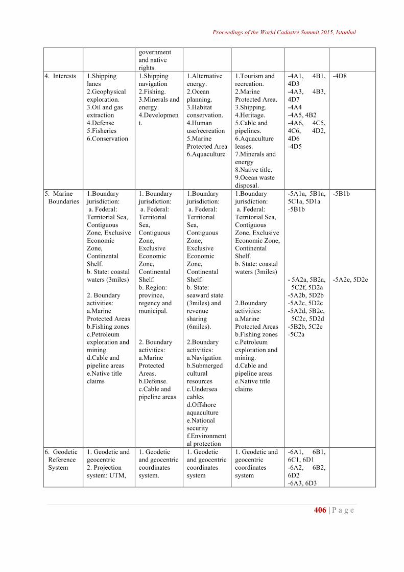
Proceedings of the World Cadastre Summit 2015, Istanbul
406 | P a g e
government and native rights.
4. Interests 1.Shipping lanes 2.Geophysical exploration. 3.Oil and gas extraction 4.Defense 5.Fisheries 6.Conservation
1.Shipping navigation 2.Fishing. 3.Minerals and energy. 4.Development.
1.Alternative energy. 2.Ocean planning. 3.Habitat conservation. 4.Human use/recreation 5.Marine Protected Area 6.Aquaculture
1.Tourism and recreation. 2.Marine Protected Area. 3.Shipping. 4.Heritage. 5.Cable and pipelines. 6.Aquaculture leases. 7.Minerals and energy 8.Native title. 9.Ocean waste disposal.
-4A1, 4B1, 4D3 -4A3, 4B3, 4D7 -4A4 -4A5, 4B2 -4A6, 4C5, 4C6, 4D2, 4D6 -4D5
-4D8
5. Marine Boundaries
1.Boundary jurisdiction: a. Federal: Territorial Sea, Contiguous Zone, Exclusive Economic Zone, Continental Shelf. b. State: coastal waters (3miles) 2. Boundary activities: a.Marine Protected Areas b.Fishing zones c.Petroleum exploration and mining. d.Cable and pipeline areas e.Native title claims
1. Boundary jurisdiction: a. Federal: Territorial Sea, Contiguous Zone, Exclusive Economic Zone, Continental Shelf. b. Region: province, regency and municipal. 2. Boundary activities: a.Marine Protected Areas. b.Defense. c.Cable and pipeline areas
1.Boundary jurisdiction: a. Federal: Territorial Sea, Contiguous Zone, Exclusive Economic Zone, Continental Shelf. b. State: seaward state (3miles) and revenue sharing (6miles). 2.Boundary activities: a.Navigation b.Submerged cultural resources c.Undersea cables d.Offshore aquaculture e.National security f.Environmental protection
1.Boundary jurisdiction: a. Federal: Territorial Sea, Contiguous Zone, Exclusive Economic Zone, Continental Shelf. b. State: coastal waters (3miles) 2.Boundary activities: a.Marine Protected Areas b.Fishing zones c.Petroleum exploration and mining. d.Cable and pipeline areas e.Native title claims
-5A1a, 5B1a, 5C1a, 5D1a -5B1b - 5A2a, 5B2a, 5C2f, 5D2a -5A2b, 5D2b -5A2c, 5D2c -5A2d, 5B2c, 5C2c, 5D2d -5B2b, 5C2e -5C2a
-5B1b -5A2e, 5D2e
6. Geodetic Reference System
1. Geodetic and geocentric 2. Projection system: UTM,
1. Geodetic and geocentric coordinates system.
1. Geodetic and geocentric coordinates system
1. Geodetic and geocentric coordinates system
-6A1, 6B1, 6C1, 6D1 -6A2, 6B2, 6D2 -6A3, 6D3
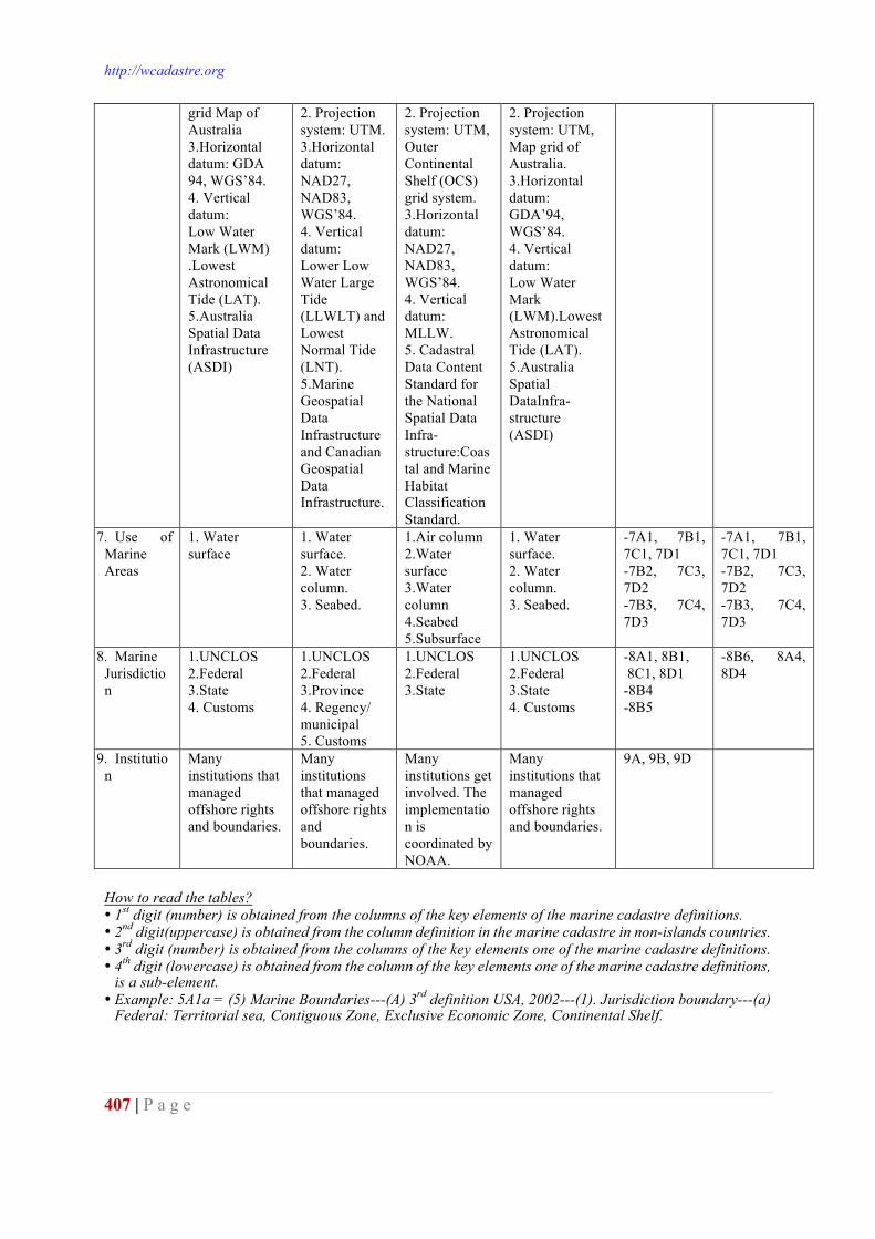
http://wcadastre.org
407 | P a g e
grid Map of Australia 3.Horizontal datum: GDA 94, WGS’84. 4. Vertical datum: Low Water Mark (LWM) .Lowest Astronomical Tide (LAT). 5.Australia Spatial Data Infrastructure (ASDI)
2. Projection system: UTM. 3.Horizontal datum: NAD27, NAD83, WGS’84. 4. Vertical datum: Lower Low Water Large Tide (LLWLT) and Lowest Normal Tide (LNT). 5.Marine Geospatial Data Infrastructure and Canadian Geospatial Data Infrastructure.
2. Projection system: UTM, Outer Continental Shelf (OCS) grid system. 3.Horizontal datum: NAD27, NAD83, WGS’84. 4. Vertical datum: MLLW. 5. Cadastral Data Content Standard for the National Spatial Data Infra-structure:Coastal and Marine Habitat Classification Standard.
2. Projection system: UTM, Map grid of Australia. 3.Horizontal datum: GDA’94, WGS’84. 4. Vertical datum: Low Water Mark (LWM).Lowest Astronomical Tide (LAT). 5.Australia Spatial DataInfra-structure (ASDI)
7. Use of Marine Areas
1. Water surface
1. Water surface. 2. Water column. 3. Seabed.
1.Air column 2.Water surface 3.Water column 4.Seabed 5.Subsurface
1. Water surface. 2. Water column. 3. Seabed.
-7A1, 7B1, 7C1, 7D1 -7B2, 7C3, 7D2 -7B3, 7C4, 7D3
-7A1, 7B1, 7C1, 7D1 -7B2, 7C3, 7D2 -7B3, 7C4, 7D3
8. Marine Jurisdiction
1.UNCLOS 2.Federal 3.State 4. Customs
1.UNCLOS 2.Federal 3.Province 4. Regency/ municipal 5. Customs
1.UNCLOS 2.Federal 3.State
1.UNCLOS 2.Federal 3.State 4. Customs
-8A1, 8B1, 8C1, 8D1 -8B4 -8B5
-8B6, 8A4, 8D4
9. Institution
Many institutions that managed offshore rights and boundaries.
Many institutions that managed offshore rights and boundaries.
Many institutions get involved. The implementation is coordinated by NOAA.
Many institutions that managed offshore rights and boundaries.
9A, 9B, 9D
How to read the tables? • 1st digit (number) is obtained from the columns of the key elements of the marine cadastre definitions. • 2nd digit(uppercase) is obtained from the column definition in the marine cadastre in non-islands countries. • 3rd digit (number) is obtained from the columns of the key elements one of the marine cadastre definitions. • 4th digit (lowercase) is obtained from the column of the key elements one of the marine cadastre definitions,
is a sub-element. • Example: 5A1a = (5) Marine Boundaries---(A) 3rd definition USA, 2002---(1). Jurisdiction boundary---(a)
Federal: Territorial sea, Contiguous Zone, Exclusive Economic Zone, Continental Shelf.
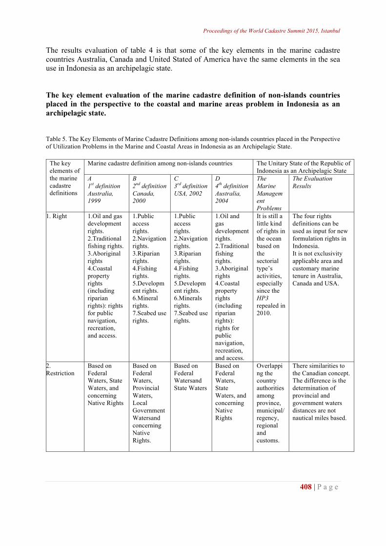
Proceedings of the World Cadastre Summit 2015, Istanbul
408 | P a g e
The results evaluation of table 4 is that some of the key elements in the marine cadastre countries Australia, Canada and United Stated of America have the same elements in the sea use in Indonesia as an archipelagic state. The key element evaluation of the marine cadastre definition of non-islands countries placed in the perspective to the coastal and marine areas problem in Indonesia as an archipelagic state. Table 5. The Key Elements of Marine Cadastre Definitions among non-islands countries placed in the Perspective of Utilization Problems in the Marine and Coastal Areas in Indonesia as an Archipelagic State.
The key elements of the marine cadastre definitions
Marine cadastre definition among non-islands countries The Unitary State of the Republic of Indonesia as an Archipelagic State
A 1st definition Australia, 1999
B 2nd definition Canada, 2000
C 3rd definition USA, 2002
D 4th definition Australia, 2004
The Marine Management Problems
The Evaluation Results
1. Right 1.Oil and gas development rights. 2.Traditional fishing rights. 3.Aboriginal rights 4.Coastal property rights (including riparian rights): rights for public navigation, recreation, and access.
1.Public access rights. 2.Navigation rights. 3.Riparian rights. 4.Fishing rights. 5.Development rights. 6.Mineral rights. 7.Seabed use rights.
1.Public access rights. 2.Navigation rights. 3.Riparian rights. 4.Fishing rights. 5.Development rights. 6.Minerals rights. 7.Seabed use rights.
1.Oil and gas development rights. 2.Traditional fishing rights. 3.Aboriginal rights 4.Coastal property rights (including riparian rights): rights for public navigation, recreation, and access.
It is still a little kind of rights in the ocean based on the sectorial type’s activities, especially since the HP3 repealed in 2010.
The four rights definitions can be used as input for new formulation rights in Indonesia. It is not exclusivity applicable area and customary marine tenure in Australia, Canada and USA.
2. Restriction
Based on Federal Waters, State Waters, and concerning Native Rights
Based on Federal Waters, Provincial Waters, Local Government Watersand concerning Native Rights.
Based on Federal Watersand State Waters
Based on Federal Waters, State Waters, and concerning Native Rights
Overlapping the country authorities among province, municipal/ regency, regional and customs.
There similarities to the Canadian concept. The difference is the determination of provincial and government waters distances are not nautical miles based.
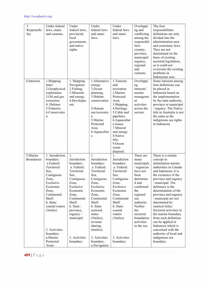
http://wcadastre.org
409 | P a g e
3. Responsibility
Under federal laws, states and customs.
Under federal laws, provincial, local government, and native rights.
Under federal laws and states laws.
Under federal laws and states laws.
Overlapping and conflicting among the responsibilities: country, province, municipal/ regency, regional and customs.
The four responsibilities definitions are only divided into the administration area and customary laws. They are not determined on the basis of existing sectorial legislation, so it could not overcome the existing problems in Indonesian seas.
4.Interests 1.Shipping lanes 2.Geophysical exploration. 3.Oil and gas extraction 4. Defense 5.Fisheries 6.Conservation
1. Shipping Navigation 2.Fishing. 3.Minerals and energy. 4.Development.
1.Alternative energy. 2.Ocean planning. 3.Habitat conservation. 4.Human use/recreation 5.Marine Protected Area 6.Aquaculture
1.Tourism and recreation. 2.Marine Protected Area. 3.Shipping. 4.Heritage. 5.Cable and pipelines. 6.Aquaculture leases. 7.Mineral and energy 8.Native title. 9.Ocean waste disposal.
Overlapping interests’marine management activities across the sectors.
Some interests among four definitions can be placed in Indonesia based on the implementation by the state authority, province or municipal / regency. The Native title in Australia is not the same as the indigenous sea rights in Indonesia.
5.Marine Boundaries
1. Jurisdiction boundary: a.Federal: Territorial Sea, Contiguous Zone, Exclusive Economic Zone, Continental Shelf. b. State: coastal waters (3miles) 2. Activities boundary: a.Marine Protected Areas
1. Jurisdiction boundary: a. Federal: Territorial Sea, Contiguous Zone, Exclusive Economic Zone, Continental Shelf. b. State : province, regency / municipal 2. Activities boundary:
1. Jurisdiction boundary: a. Federal: Territorial Sea, Contiguous Zone, Exclusive Economic Zone, Continental Shelf. b. State: seaward states (3miles), revenue sharing (6miles). 2. Activities boundary : a.Navigation
1. Jurisdiction boundary: a. Federal: Territorial Sea, Contiguous Zone, Exclusive Economic Zone, Continental Shelf. b. State: coastal waters (3miles) 2. Activities boundary:
There are many municipals/ regencies have not been determined and confirmed the regional sea authority. Neither the sectorial boundaries activities in the sea.
There is a similar concept in delimitation marine authorities in Canada and Indonesia; it is the existence of the province and regency / municipal. The deference is the determination of the province and regency / municipal are not determined by nautical miles. Sectorial activities in the marine boundary from each definition can be applied in Indonesia which is concerned with the authority of local and indigenous sea boundary.
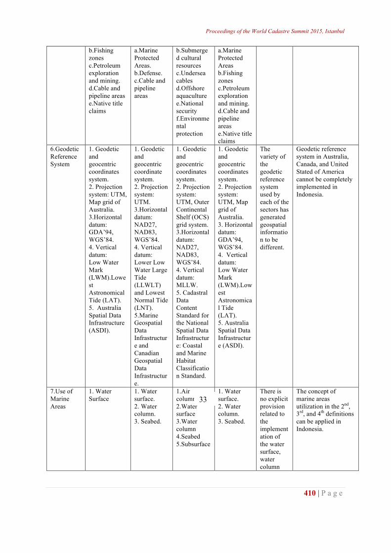
Proceedings of the World Cadastre Summit 2015, Istanbul
410 | P a g e
b.Fishing zones c.Petroleum exploration and mining. d.Cable and pipeline areas e.Native title claims
a.Marine Protected Areas. b.Defense. c.Cable and pipeline areas
b.Submerged cultural resources c.Undersea cables d.Offshore aquaculture e.National security f.Environmental protection
a.Marine Protected Areas b.Fishing zones c.Petroleum exploration and mining. d.Cable and pipeline areas e.Native title claims
6.Geodetic Reference System
1. Geodetic and geocentric coordinates system. 2. Projection system: UTM, Map grid of Australia. 3.Horizontal datum: GDA’94, WGS’84. 4. Vertical datum: Low Water Mark (LWM).Lowest Astronomical Tide (LAT). 5. Australia Spatial Data Infrastructure (ASDI).
1. Geodetic and geocentric coordinate system. 2. Projection system: UTM. 3.Horizontal datum: NAD27, NAD83, WGS’84. 4. Vertical datum: Lower Low Water Large Tide (LLWLT) and Lowest Normal Tide (LNT). 5.Marine Geospatial Data Infrastructure and Canadian Geospatial Data Infrastructure.
1. Geodetic and geocentric coordinates system. 2. Projection system: UTM, Outer Continental Shelf (OCS) grid system. 3.Horizontal datum: NAD27, NAD83, WGS’84. 4. Vertical datum: MLLW. 5. Cadastral Data Content Standard for the National Spatial Data Infrastructure: Coastal and Marine Habitat Classification Standard.
1. Geodetic and geocentric coordinates system. 2. Projection system: UTM, Map grid of Australia. 3. Horizontal datum: GDA’94, WGS’84. 4. Vertical datum: Low Water Mark (LWM).Lowest Astronomical Tide (LAT). 5. Australia Spatial Data Infrastructure (ASDI).
The variety of the geodetic reference system used by each of the sectors has generated geospatial information to be different.
Geodetic reference system in Australia, Canada, and United Stated of America cannot be completely implemented in Indonesia.
7.Use of Marine Areas
1. Water Surface
1. Water surface. 2. Water column. 3. Seabed.
1.Air column 2.Water surface 3.Water column 4.Seabed 5.Subsurface
1. Water surface. 2. Water column. 3. Seabed.
There is no explicit provision related to the implementation of the water surface, water column
The concept of marine areas utilization in the 2nd, 3rd, and 4th definitions can be applied in Indonesia.
33
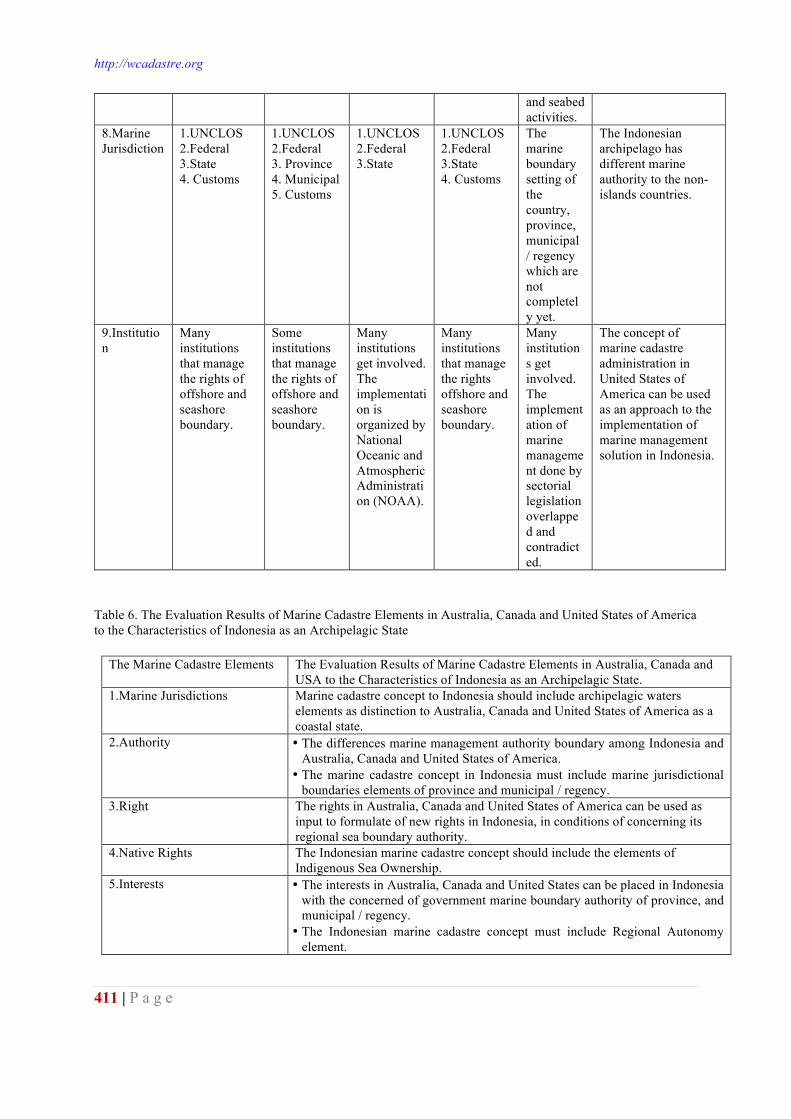
http://wcadastre.org
411 | P a g e
and seabed activities.
8.Marine Jurisdiction
1.UNCLOS 2.Federal 3.State 4. Customs
1.UNCLOS 2.Federal 3. Province 4. Municipal 5. Customs
1.UNCLOS 2.Federal 3.State
1.UNCLOS 2.Federal 3.State 4. Customs
The marine boundary setting of the country, province, municipal / regency which are not completely yet.
The Indonesian archipelago has different marine authority to the non-islands countries.
9.Institution
Many institutions that manage the rights of offshore and seashore boundary.
Some institutions that manage the rights of offshore and seashore boundary.
Many institutions get involved. The implementation is organized by National Oceanic and Atmospheric Administration (NOAA).
Many institutions that manage the rights offshore and seashore boundary.
Many institutions get involved. The implementation of marine management done by sectorial legislation overlapped and contradicted.
The concept of marine cadastre administration in United States of America can be used as an approach to the implementation of marine management solution in Indonesia.
Table 6. The Evaluation Results of Marine Cadastre Elements in Australia, Canada and United States of America to the Characteristics of Indonesia as an Archipelagic State
The Marine Cadastre Elements The Evaluation Results of Marine Cadastre Elements in Australia, Canada and USA to the Characteristics of Indonesia as an Archipelagic State.
1.Marine Jurisdictions Marine cadastre concept to Indonesia should include archipelagic waters elements as distinction to Australia, Canada and United States of America as a coastal state.
2.Authority • The differences marine management authority boundary among Indonesia and Australia, Canada and United States of America.
• The marine cadastre concept in Indonesia must include marine jurisdictional boundaries elements of province and municipal / regency.
3.Right The rights in Australia, Canada and United States of America can be used as input to formulate of new rights in Indonesia, in conditions of concerning its regional sea boundary authority.
4.Native Rights The Indonesian marine cadastre concept should include the elements of Indigenous Sea Ownership.
5.Interests • The interests in Australia, Canada and United States can be placed in Indonesia with the concerned of government marine boundary authority of province, and municipal / regency.
• The Indonesian marine cadastre concept must include Regional Autonomy element.
Proceedings of the World Cadastre Summit 2015, Istanbul
412 | P a g e
6.Restriction The restrictions in Australia, Canada and United States cannot be implemented in Indonesia caused by the elements of the archipelagic state sovereignty, regional autonomy and customary marine laws authority that applied in Indonesia.
7.Responsibility The responsibilities in Australia, Canada and United states of America cannot be implemented in Indonesia caused by the elements of the archipelagic state sovereignty, regional autonomy and customary marine laws authority that applied in Indonesia.
8.Marine Boundaries The Marine Boundaries in Australia, Canada and United States cannot be implemented in Indonesia because of: • The sovereignty distinction countries. • The marine boundary authority of the province and municipal / regency. • The prevailing customary sea boundary in Indonesia
9.Geodetic Reference System • Geodetic reference system in Australia, Canada and United States of America cannot be completely implemented in Indonesia.
• Required use the same geospatial reference system to the variety of marine utilization activities.
10.Institution The implementation of marine cadastre concept in United States of America can be used as an approach to the application of marine management solution in Indonesia.
The above results should be completed by the disaster mitigation elements. The Indonesian geographical position is located in the track of fire ring to make this country as a prone to catastrophic volcanic eruptions and earthquakes, coupled with the tsunami disaster and abrasion. The disasters impact that might occur is the loos of rights, restriction and responsibility of a person or parcel on the coastal use and marine resources, so it is needed reconstruction activities boundaries utilization and re-recording of the object and the subject of utilization. CONCLUSION AND RECOMMENDATION Australian marine cadastre definition builds upon the sea jurisdiction which provides for the authority of state marine use (3 miles) and the federal sea. In Indonesian point of views as an archipelagic state, the definition formulated by Hoogsteden, Robertson and Benweel in 1999 contains the concept of local autonomy in natural resource management perspective. While other the marine cadastre definition formulated by Binns in 2004 contains the cross-sectorial concept activities in the national view. Canadian marine cadastre definition builds upon the sea jurisdiction and is strongly influenced by the authority of sea utilization in federal, province, regency and municipal, even though it does not provide the authority of sea boundary determined by nautical distance. In Indonesian archipelago point of view, this definition contains the regional autonomy concept in natural resource management perspective. American marine cadastre definition builds upon the sea jurisdiction that sets the authority marine boundary use both federal and state (3 miles, except Texas and Florida Bay 9 miles). In Indonesian point of views, this definition contains the rule of law concept to resolve conflicts at marine activities.
http://wcadastre.org
413 | P a g e
Thus, the existing marine cadastre definitions among Australia, Canada and United States of America cannot be used in Indonesia. As a highlight, marine cadastre is concerned with how a country, especially Indonesia archipelago in managing and governing the marine resources administration. This condition causes the marine cadastre definitions among non-islands nations namely Australia, Canada and United States of America cannot be implemented in Indonesian coastal and marine areas. Required marine cadastre precise definition according to the characteristics of Indonesia as an archipelagic nation. The marine cadastre definition in this country should incorporate jurisdictional boundaries elements of the province, and regency/ municipal, the coastal and small islands areas management, and also concern the existence of customary marine law recognized by the government. REFERENCES Abdulharis, R., Djunarsjah, E., dan Hernandi, A.(2008): Stakeholder Analysis on Implementation of
Marine Cadastre in Indonesia, Proceedings FIG Working Week, Stockholm, Swedia. Binns, A. (2004): Defining a Marine Cadastre: Legal and Institutional Aspects. Thesis. Department of
Geomatics, The University of Melbourne, Australia. Binns, A., Rajabifard, A., Collier, P.A and Williamson, I. Developing the Concept of a Marine
Cadastre: An Australia Case Study, Department of Geomatics, The University of Melbourne, Australia.
Djunarsjah, E. (2008):The Study on the Technical and Legal Aspect of Marine Cadastre in Indonesia toward Natural Resources Preservation and Sustainable Development, LPPM – ITB, Bandung.
Djunarsjah, E. (2011): Measuring and Mapping Technical Procedures Waters Space (Pilot Project in the framework of Measurement and Mapping Services Waters Activities, The cooperated BPN RI and LPPM ITB.
Falah. (2010): Assessment of Marine cadastre Technical Aspects of Three Dimensional (Case Study: Coastal Tanjungpinang Riau Island Province), Final Project, Department of Geodesy Geomatics, ITB.
Faridha, D. (2010): Identification of Objects Cadastre Sea Waters Less than Twelve Nautical Miles from Base Line Islands, Final Project,Department of Geodesy Geomatics, ITB.
Fraser, R., Todd, P., and Collier, P. (2003): Issues in the Development of a Marine Cadastre, Department of Geomatics, The University of Melbourne, Australia.
Harbimaharani, H. (2010): Study on Waters Cadastre Marine Policy, Final Project, Department of Geodesy and Geomatics, ITB.
Hasymi, F. (2008): Determination Limit as Supporting implementation of Regional Sea Marine Cadastre in Indonesia, Final Project, Department of Geodesy and Geomatics, ITB.
Hendriatiningsih, S.,and Kurniawan, I. (2007):Study on Technical Aspects of Marine Cadastre, IV Annual Science Meeting of Geomatics Engineering ITS, Surabaya.
Hernandi, A., Abdulharis, R., Hendriatiningsih, S., andLing, M. (2012): An Institutional Analysis of Customary Marine Tenure in Maluku: Towards Implementation Marine Cadastre in Indonesia, Proceedings FIGWorking Week, Rome, Italia.
Imron. (2010): Identification of Objects Cadastre Sea Waters Outside 12 Nautical Miles, Final Project, Department of Geodesy and Geomatics, ITB
Ives, D., Yan, Y.C. (2004): A Report on Commonwealth Association for Public Administration and Management/ CAPAM’s 10th Anniversary Biennial Conference, Singapore.
Mårtensson. (2004): The French Ecologic Protection Zone-Developing Marine Environmental Protection in International Law.
Ng'ang'a., Nichols., Sutherland., and Cockburn. (2001): Towards A Multidimensional Marine Cadastre in Support of Good Ocean Governance, Canada.
Proceedings of the World Cadastre Summit 2015, Istanbul
414 | P a g e
Ng'ang'a., and Nichols. (2002): The Role of Bathymetry Data in a Marine Cadastre: Lessons from The Proposed Musquash Marine Protected Area, University of New Brunswick Canada.
Rais, J. (2009): Introduction to Marine Cadastre in Indonesia, ISI Journal - Diponegoro University, Semarang.
Sesli, F., and Uslu, G. (2010): The importance of marine cadastre for Turkey, African Journal of Agricultural Research Vol. 5(14), pp. 1749-1758.
Sook, H., Lee., andShin, D. (2010): Issues with Building a Marine Cadastre System in South Korea, Proceedings FIG Working Week, Sydney, Australia.
Steudler, D. (2004): A Framework for the Evaluation of Land Administration Systems, Thesis, Department of Geomatics, The University of Melbourne, Victoria 3010, Australia.
Steudler, D., Rajbifard, A., and Williamson, I.P. (2004):Evaluation of Land Administration Systems, Journal for Land Use Policy, Department of Geomatics, The University of Melbourne, Victoria 3010, Australia.
Srebo, H., Fabrikant, I., and Marom, O. (2010): Towards a Marine Cadastre in Israel, Proceedings FIG Working Week, Sydney, Australia.
Sulasdi, W.N. (2010): Actual Level Components Integrality Mapping in Coastal and Ocean Engineering in Indonesia, Professor of Speech Scientific Institute of Technology Bandung
Sulasdi, W.N. (2007): Optimization Hydrographic Engineering, Coastal and Marine Science and Engineering Research Group Hydrographic, ITB
Sulistiyo, B. (2004): A Marine Cadastre Thought as a Step toward Structuring Sea Region, Journals, Marine and Fisheries Research Agency.
Tamtomo, J.P. (2004): The Needs for Building Concept and Authorizing Implementation of Marine Cadastre in Indonesia, Journals, Indonesia.
Tamtomo, J.P. (2006): Analysis of Land Use Policies in Coastal and Marine Framework “Marine Cadastre” (Case Study in the Island of Bintan, Riau Islands), Dissertation Doctoral Program, IPB.
UN-FIG. (1999): The Bathurst Declaration on Land Administration for SustainableDevelopment. Report from the UN-FIG Workshop on "Land Tenure and Cadastral Infrastructures for Sustainable Development", Bathurst, NSW, Australia.
Vaez., S. (2009): Marine Cadastre and Marine Administration, Short Course on Modern Cadastre and Land Administration, University of Melbourne, Australia.
Wisayantono, D. (2009): Spatial Optimization Ratio in the Management of Land Resources Sustainable Coastal Zone, Dissertation Doctoral Program, ITB.
Waljiyanto. (1998): Cadastre as Based Land Information System, National Seminar Dies Natalie XXVIII KMTG FT-UGM, September 28, 1998, Yogyakarta.
Widodo, S. (2004): Relationship of Marine Cadastre and Marine Spatial Planning in Indonesia, Journals, Indonesia.
Williamson, I., Enemark, S., Wallace, J., and Rajabifard, A. (2010): Land Administration for Sustainable Development, Esri.
Yuwono. (2006): Utilization of marine Surveying and Mapping for Cadastre toward the Sea (Marine Cadastre), Journals, Geomatics Engineering, FTSP-ITS.
Zaenudin, D. (2008): Study of the Application of Legal Aspects of Marine Cadastre in Maluku Province, Final Project, Department of Geodesy and Geomatics, ITB.
http://wcadastre.org
415 | P a g e
SUSTAINABLE MARINE SPACE MANAGEMENTS: MALAYSIA PERSPECTIVE
Abdullah Hisham Omar1, Nazirah Mohamad Abdullah2, Shuib Rambat3
Noor Anim Zanariah Yahaya4 Rasheila Rahibulsadri5 Asraf Abdullah6, Rahim Yahya7, Hasan Jamil8, Teng Chee Hua9, Chan Keat Lim10
1,2,3,4,5,6Department of Geoinformation, Faculty of Geoinformation & Real Estate, UTM
Skudai, 81310, Johor, Malaysia [email protected]; [email protected]
6Faculty of Architecture, Planning and Survey, Universiti Teknologi Mara, Malaysia Kampus Perlis, 02600, Arau, Perlis - [email protected]
7SMK Tun Perak, KM 4, Jalan Salleh, 84000, Muar, Johor, Malaysia - [email protected] 8,9,10Cadastral Division, Department of Survey and Mapping Malaysia, Department of Survey
and Mapping Malaysia, Wisma JUPEM, Jalan Semarak, 50578 Kuala Lumpur ABSTRACT The management of good governance of marine space administration has been debated since at least the 2000s. An extensive literature and research report, it is hardly surprising that this marine space is under serious threat from a myriad of overlapping and conflicting interests, where the evidence of change is compelling and manifest. Therefore it is imperative to manage, administer and govern the coastal zone in a considerable, sustainable and structural manner as well as to protect and nurture the environment we live in. Failure to do so may have disastrous consequences for future generations. This includes polishing the management system, particularly the governance of marine space administrative to support marine rights. Marine space administration and management can help to improve our governance and information systems on coastal and marine areas. From the perspective of management, Malaysia has many institutions that manage and administering the marine environment. However, the developing of institutional framework is still uncertain with ambiguities, conflicts and overlapping on administration and management models due to the bill of act. This paper proposed method of the implanting marine space governance. Key words: Sustainable Marine Space Administration, Marine Space Governance, Marine Space Administrative Issues INTRODUCTION Marine administration has been defined as governing surrounding of the marine space. Governing the surrounding marine space tasks may include sustaining the natural environment, maintaining conservation and managing the resources. In Malaysia, governing such activities involves various departments at government stage as well as the stakeholder. Managing a marine space with approximately, 515,000 kilometres square area which covered by maritime realm and 4,576 km in length by coastline is a tedious task (Teo & Fauzi, 2006). Indeed,the
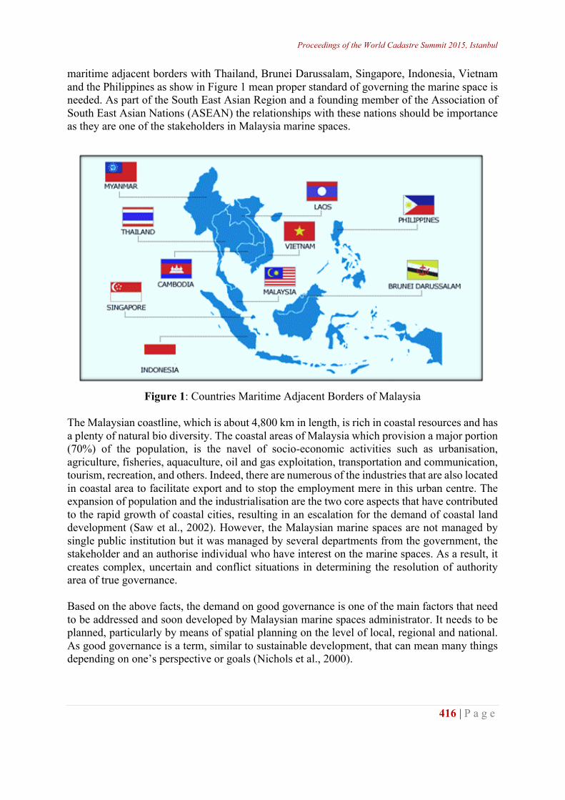
Proceedings of the World Cadastre Summit 2015, Istanbul
416 | P a g e
maritime adjacent borders with Thailand, Brunei Darussalam, Singapore, Indonesia, Vietnam and the Philippines as show in Figure 1 mean proper standard of governing the marine space is needed. As part of the South East Asian Region and a founding member of the Association of South East Asian Nations (ASEAN) the relationships with these nations should be importance as they are one of the stakeholders in Malaysia marine spaces.
Figure 1: Countries Maritime Adjacent Borders of Malaysia
The Malaysian coastline, which is about 4,800 km in length, is rich in coastal resources and has a plenty of natural bio diversity. The coastal areas of Malaysia which provision a major portion (70%) of the population, is the navel of socio-economic activities such as urbanisation, agriculture, fisheries, aquaculture, oil and gas exploitation, transportation and communication, tourism, recreation, and others. Indeed, there are numerous of the industries that are also located in coastal area to facilitate export and to stop the employment mere in this urban centre. The expansion of population and the industrialisation are the two core aspects that have contributed to the rapid growth of coastal cities, resulting in an escalation for the demand of coastal land development (Saw et al., 2002). However, the Malaysian marine spaces are not managed by single public institution but it was managed by several departments from the government, the stakeholder and an authorise individual who have interest on the marine spaces. As a result, it creates complex, uncertain and conflict situations in determining the resolution of authority area of true governance. Based on the above facts, the demand on good governance is one of the main factors that need to be addressed and soon developed by Malaysian marine spaces administrator. It needs to be planned, particularly by means of spatial planning on the level of local, regional and national. As good governance is a term, similar to sustainable development, that can mean many things depending on one’s perspective or goals (Nichols et al., 2000).
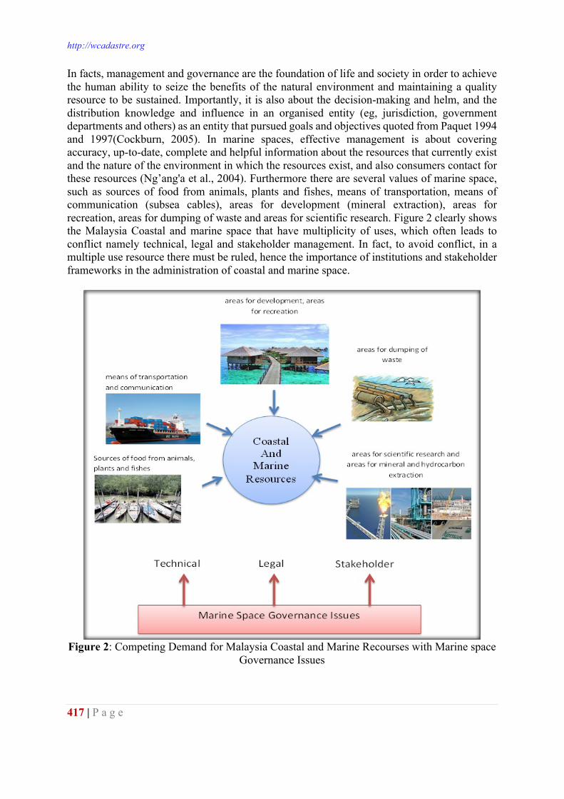
http://wcadastre.org
417 | P a g e
In facts, management and governance are the foundation of life and society in order to achieve the human ability to seize the benefits of the natural environment and maintaining a quality resource to be sustained. Importantly, it is also about the decision-making and helm, and the distribution knowledge and influence in an organised entity (eg, jurisdiction, government departments and others) as an entity that pursued goals and objectives quoted from Paquet 1994 and 1997(Cockburn, 2005). In marine spaces, effective management is about covering accuracy, up-to-date, complete and helpful information about the resources that currently exist and the nature of the environment in which the resources exist, and also consumers contact for these resources (Ng’ang'a et al., 2004). Furthermore there are several values of marine space, such as sources of food from animals, plants and fishes, means of transportation, means of communication (subsea cables), areas for development (mineral extraction), areas for recreation, areas for dumping of waste and areas for scientific research. Figure 2 clearly shows the Malaysia Coastal and marine space that have multiplicity of uses, which often leads to conflict namely technical, legal and stakeholder management. In fact, to avoid conflict, in a multiple use resource there must be ruled, hence the importance of institutions and stakeholder frameworks in the administration of coastal and marine space.
Figure 2: Competing Demand for Malaysia Coastal and Marine Recourses with Marine space
Governance Issues
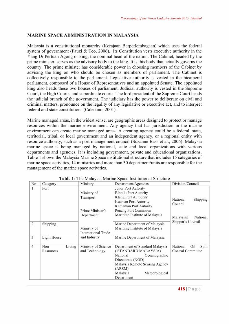
Proceedings of the World Cadastre Summit 2015, Istanbul
418 | P a g e
MARINE SPACE ADMINISTRATION IN MALAYSIA Malaysia is a constitutional monarchy (Kerajaan Berperlembagaan) which uses the federal system of government (Fauzi & Teo, 2006). Its Constitution vests executive authority in the Yang Di Pertuan Agong or king, the nominal head of the nation. The Cabinet, headed by the prime minister, serves as the advisory body to the king. It is this body that actually governs the country. The prime minister has considerable power in choosing members of the Cabinet by advising the king on who should be chosen as members of parliament. The Cabinet is collectively responsible to the parliament. Legislative authority is vested in the bicameral parliament, composed of a House of Representatives and an appointed Senate. The appointed king also heads these two houses of parliament. Judicial authority is vested in the Supreme Court, the High Courts, and subordinate courts. The lord president of the Supreme Court heads the judicial branch of the government. The judiciary has the power to deliberate on civil and criminal matters, pronounce on the legality of any legislative or executive act, and to interpret federal and state constitutions (Calestino, 2001). Marine managed areas, in the widest sense, are geographic areas designed to protect or manage resources within the marine environment. Any agency that has jurisdiction in the marine environment can create marine managed areas. A creating agency could be a federal, state, territorial, tribal, or local government and an independent agency, or a regional entity with resource authority, such as a port management council (Suzanne Bass et al., 2006). Malaysia marine space is being managed by national, state and local organizations with various departments and agencies. It is including government, private and educational organizations. Table 1 shown the Malaysia Marine Space institutional structure that includes 15 categories of marine space activities, 14 ministries and more than 30 department/units are responsible for the management of the marine space activities.
Table 1: The Malaysia Marine Space Institutional Structure No Category Ministry Department/Agencies Division/Council 1 Port
Ministry of Transport Prime Minister’s Department Ministry of International Trade and Industry
Johor Port Autority Bintulu Port Autority Klang Port Authority Kuantan Port Autority Kemaman Port Autority Penang Port Comission Maritime Institute of Malaysia
National Shipping Council Malaysian National Shipper’s Council 2 Shipping Marine Department of Malaysia
Maritime Institute of Malaysia
3 Light House Marine Department of Malaysia
4 Non Living Resources
Ministry of Science and Technology
Department of Standard Malaysia ( STANDARD MALAYSIA) National Oceanographic Directorate (NOD) Malaysia Remote Sensing Agency (ARSM) Malaysia Meteorological Department
National Oil Spill Control Committee
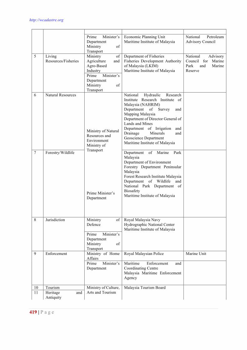
http://wcadastre.org
419 | P a g e
Prime Minister’s Department Ministry of Transport
Economic Planning Unit Maritime Institute of Malaysia
National Petroleum Advisory Council
5 Living Resources/Fisheries
Ministry of Agriculture and Agro-Based Industry
Department of Fisheries Fisheries Development Authority of Malaysia (LKIM) Maritime Institute of Malaysia
National Advisory Council for Marine Park and Marine Reserve
Prime Minister’s Department Ministry of Transport
6 Natural Resources
Ministry of Natural Resources and Environment Ministry of Transport Prime Minister’s Department
National Hydraulic Research Institute Research Institute of Malaysia (NAHRIM) Department of Survey and Mapping Malaysia Department of Director General of Lands and Mines Department of Irrigation and Drainage Minerals and Geoscience Department Maritime Institute of Malaysia
7 Forestry/Wildlife Department of Marine Park Malaysia Department of Environment Forestry Department Peninsular Malaysia Forest Research Institute Malaysia Department of Wildlife and National Park Department of Biosafety Maritime Institute of Malaysia
8 Jurisdiction Ministry of Defence
Royal Malaysia Navy Hydrographic National Center Maritime Institute of Malaysia
Prime Minister’s Department Ministry of Transport
9 Enforcement Ministry of Home Affairs
Royal Malaysian Police Marine Unit
Prime Minister’s Department
Maritime Enforcement and Coordinating Centre Malaysia Maritime Enforcement Agency
10 Tourism Ministry of Culture, Arts and Tourism
Malaysia Tourism Board
11 Heritage and
Antiquity
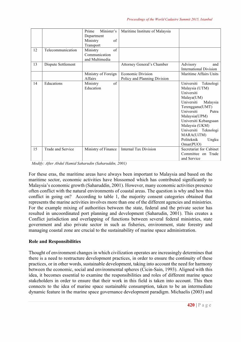
Proceedings of the World Cadastre Summit 2015, Istanbul
420 | P a g e
Modify: After Abdul Hamid Saharudin (Saharuddin, 2001) For these eras, the maritime areas have always been important to Malaysia and based on the maritime sector, economic activities have blossomed which has contributed significantly to Malaysia’s economic growth (Saharuddin, 2001). However, many economic activities presence often conflict with the natural environments of coastal areas. The question is why and how this conflict in going on? According to table 1, the majority consent categories obtained that represents the marine activities involves more than one of the different agencies and ministries. For the example mixing of authorities between the state, federal and the private sector has resulted in uncoordinated port planning and development (Saharudin, 2001). This creates a Conflict jurisdiction and overlapping of functions between several federal ministries, state government and also private sector in such as fisheries, environment, state forestry and managing coastal zone are crucial to the sustainability of marine space administration. Role and Responsibilities Thought of environment changes in which civilization operates are increasingly determines that there is a need to restructure development practices, in order to ensure the continuity of these practices, or in other words, sustainable development, taking into account the need for harmony between the economic, social and environmental spheres (Cicin-Sain, 1993). Aligned with this idea, it becomes essential to examine the responsibilities and roles of different marine space stakeholders in order to ensure that their work in this field is taken into account. This then connects to the idea of marine space sustainable consumption, taken to be an intermediate dynamic feature in the marine space governance development paradigm. Michaelis (2003) and
Prime Minister’s Department Ministry of Transport
Maritime Institute of Malaysia
12 Telecommunication Ministry of Communication and Multimedia
13 Dispute Settlement Attorney General’s Chamber Advisory and International Division
Ministry of Foreign Affairs
Economic Division Policy and Planning Division
Maritime Affairs Units
14 Educations Ministry of Education
Universiti Teknologi Malaysia (UTM) Universiti Malaya(UM) Universiti Malaysia Terengganu(UMT) Universiti Putra Malaysia(UPM) Universiti Kebangsaan Malaysia (UKM) Universiti Teknologi MARA(UiTM) Politeknik Ungku Omar(PUO)
15 Trade and Service Ministry of Finance Internal Tax Division Secretariat for Cabinet Committee on Trade and Service
http://wcadastre.org
421 | P a g e
Mont and Plepys (2007) indicate sustainable consumption as the pattern of consumption resulting from the inter-relation of stakeholders interested in achieving sustainable development. Hence, the discussions on sustainable development, it becomes increasingly clear that marine space stakeholders in different fields need to be working and assuming specific roles and responsibilities in this new context. Therefore this study tries to see the role of government, regulators and planning organisations and also role of national policy. Role of Government, Regulators and Planning Organisations Marine space administrations will be successful if supported by the appropriate law and regulation on marine management. The law and regulation is dependent on two components: local and international. The local law must be examines under marine cadastre contexts such as National Land Code 1965, Continental Shelf 1966, Territorial Sea Act 2012, State Land Rule and Baselines of Maritime Zones Act 2006. Whereas the international law is related to United Nation Convention Law of The Sea 1982 and Convention on the Territorial Sea and the Contiguous Zone 1958. Management of coastal resources management are briefly said that water and land matters fall within the jurisdiction of the State Government, which entails, development planning and zoning powers amongst others (Mokthar and Ghani Aziz, 2003). And yet the living resources are shared between the Federal and State government. The local authorities, both municipal and district councils, together with relevant government agencies (for example district land offices) act as a channel for both Federal and State government. The resourcefulness on coastal zone management in Malaysia took place when the Federal Government responded to severe coastal erosion caused by a variety of natural and man-made processes. Malaysian government consequently launched the National Coastal Erosion Study in 1984-1985 and it is become a major national concern (Mokhtar and Ghani Aziz, 2003). This research was under the responsibility of the Environment and Natural Resources Division of the Economic Planning Unit (EPU) in the Office of the Prime Minister. The important results of this research were recommendations for implementing proper long-term planning to prevent coastal erosion and establishing in 1987 two important institutions related to coastal zone management is the Coastal Engineering Technical Centre (CETC) and the National Coastal Erosion Control Council (NCECC) which lead to development of importance guidelines. The Development guidelines encapsulated in the Federal Government’s Outline Perspective Plans (which spans a period of at least 10 years) are then interpreted at State Government levels, and government agency levels, who take the directions formulated for sectors that they represent, and develop specific policy documents, programs and action plans. State government will be the actual local government of an area for all intents and purposes. They also have access and capability to raise funds, promulgate enactments and regulations, and develop development plans for areas within their boundary (Mokhtar & Ghani Aziz, 2003). There is large volume of published studies describing Malaysia has a plethora of maritime and ocean laws. With respect to the concept of unity between land and water expressed by the Malay
Proceedings of the World Cadastre Summit 2015, Istanbul
422 | P a g e
word ‘tanahair’ which literally means, ‘land and water’ depict the embodiment of the unity assumed simultaneously with the native land. In 1999, Juita Ramli (1999) described as early as 1276 during the reign of Sultan Muhammed Shah - the first sovereign of the Malacca Sultanate - it was found that the Malays has had already designed a set of laws of the sea applicable in sea areas within the jurisdiction of the Malacca Sultanate. These laws were referred to as the Malacca Code. Malacca Code is all about the laws designed were significantly related to the trading activities within the region, which thrived for centuries under the reign of the Malacca Sultanate (Ramli, 1999). It is also important to highlight that during this ancient time of living where daily lives were easily entertained, it is notable that such law and order governing matters both on land and at sea has had been well administered. Juita Ramli (1999), also pointed that the nature of victorious civilisation and it is regrettable that as beneficiaries we have failed in perpetuating or pursued to develop, in the least, the codified Malacca laws of the sea. Today, Malaysia maritime laws consist of multiple meanings and purposes established in specific needs such as to solve any disputes or issues. However, Malaysia's marine legislation does not focus on laws related to the functions of marine space and its characteristic compared to the terrestrial. Ensure success in marine space governance, Malaysian marine laws have to be first examined to have a clear understanding of the Malaysian maritime regime scenario under the scope of marine spaces. The governance of Malaysia’s maritime territory is controlled by legally defined boundaries same as on land (Fauzi, 2006) . The United Nations Convention on the Law of the Sea (UNCLOS) establishes a jurisdictional regime under which Malaysia itself can claim, manage and utilise its maritime territories. In this regards, Malaysia ratified UNCLOS in October 1996, and in line with provisions of UNCLOS, is entitled to: (i) The Territorial Sea, which is the belt of sea measured 12 nautical miles (nm) seaward
from the territorial sea baseline (Malaysia uses the straight base line approach). On 2 August 1969, an Ordinance under Article 150(2) of the Constitution known as the Emergency (Essential Powers) Ordinance, No.7, 1969 was promulgated. Under this Ordinance, the territorial waters of Malaysia (except in the Straits of Malacca, the Sulu Sea and the Celebes Sea) was declared as 12 nautical miles from the base line determined in accordance with UNCLOS.
(ii) The Contiguous Zone, which is the belt of sea, contiguous to the territorial sea, measured 24 nm seaward from the Territorial Sea Baseline.
(iii) The Exclusive Economic Zone, which is the area beyond and adjacent to the territorial sea, measured 200 nm seaward from the Territorial Sea Baseline.
Confusion occurs until precipitated the establishment of a rather irregular mix of national and international legislation in Malaysia are influence accorded by the development of world-wide laws of the sea since the advent of Western European dominance in ocean-related matters and international trading (Ramli, 1999).
http://wcadastre.org
423 | P a g e
Domestic Laws There have been several studies in the literature reporting about Malaysia’s government is modelled after the British system, somewhat modified because Malaysia’s federal structure incorporates 13 states and 3 federal territories. Nine of those states have rulers or sultans and they elect a monarch, the supreme ruler, and every five years. The government is based on a parliamentary system, headed by an elected Prime Minister. The Parliament consists of a partially appointed senate and a house of representatives whose members are elected by universal adult suffrage. The Federal Government has powers such as over external affairs, defence, internal security, civil and criminal law, federal citizenship and naturalization, finance, trade, commerce and industry, taxation, customs and excise duties, shipping, navigation and fisheries, communications and transport, federal works and power, education, medicine and health, social security and tourism. The States’ powers include over land and its administration, Islamic law, Malay customs, permits and licenses for mines prospecting, agriculture, forests, local government, states works and water, and riverside fishing. It is essential to heed at this juncture that all of the pre-Federation of Malaysia laws were derived from British domestic laws. It has conclusively been shown from paragraph below. Malaysia’s earliest recorded 20th. Century national law - considered remotely relating to management of maritime matters - is the Waters Act, 1920 enacted to provide for the control of rivers and streams. It was not until 20 years later when the Federation of Malaya became an active rubber producer in the region that the Rubber Shipping and Packing Control Ordinance, 1949 was promulgated for the purposes of regulating shipping and packing of rubber for export. In the following years we may observe that domestic laws pertinent to shipping, navigation and port were duly promulgated and enforced. These included Carriage of Goods by Sea Act, 1950; Merchant Shipping Ordinance, 1952; Federation Light Dues Act, 1953; Penang Port Commission Act, 1955; Port Authorities Act, 1963 and so on. This trend was consistent with pre-Merdeka and pre-Federation of Malaysia days when the ruling British were active in pursuing interests in maritime trade arising from an abundance of agricultural produce in the Malay States. ( Ramli, 1999) International Laws As highlighted by Aziz Meo Ngah & Nazery Khalid (2014) Malaysia is one of the world’s major trading nations and its economic wellbeing depends largely on trade, 95% of which is carried though seaborne mean. Malaysia is subjected to international laws in marine matters and various treaties and resolutions have been sealed. The international consultation needs Malaysia to take the relationship with international institutions seriously in deciding to join the international maritime legislation to clarify the rights of marine territory of a country. Malaysia should understand and defend its rights and policies in accordance to the rules of international laws for recognition as a sovereignty of country’s maritime. Until now, Malaysia has adopted the international laws in the implementation of all the functions and powers for marine administration and is related to the local legislation as showed in table 2. This information was summary from Country Report (Fauzi, 2006) and Juita Ramli (1999) writing.
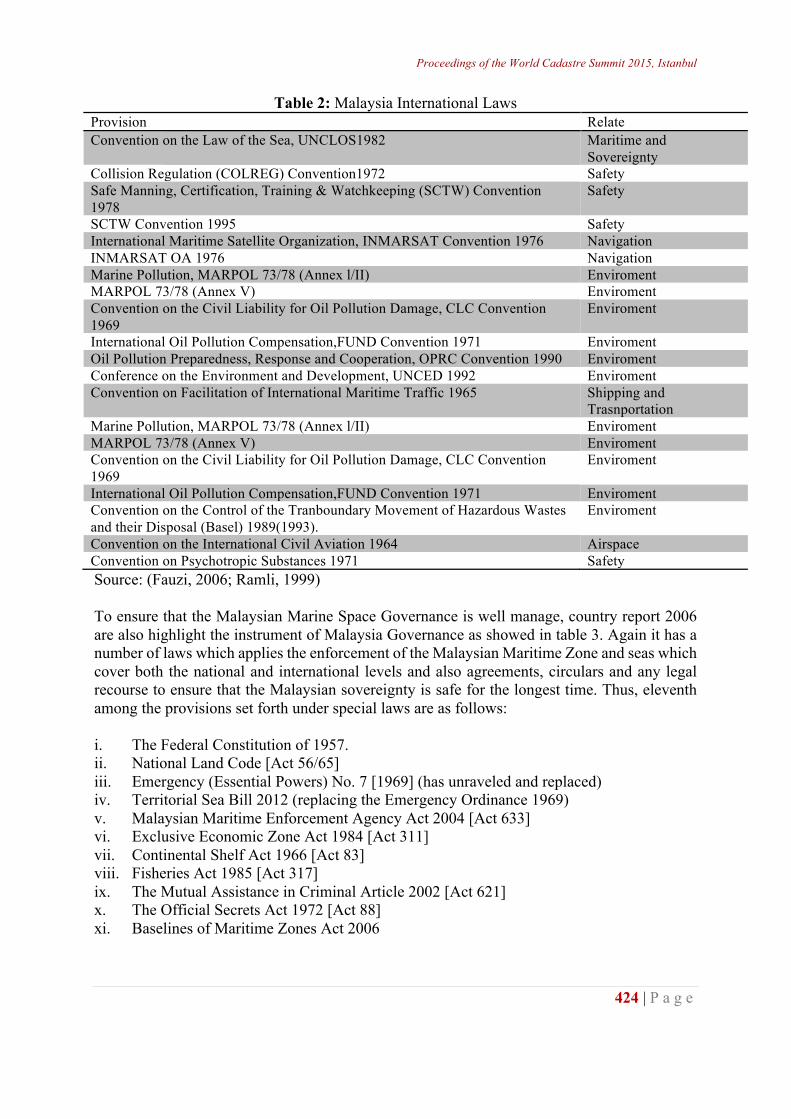
Proceedings of the World Cadastre Summit 2015, Istanbul
424 | P a g e
Table 2: Malaysia International Laws Provision Relate Convention on the Law of the Sea, UNCLOS1982
Maritime and Sovereignty
Collision Regulation (COLREG) Convention1972 Safety Safe Manning, Certification, Training & Watchkeeping (SCTW) Convention 1978
Safety
SCTW Convention 1995 Safety International Maritime Satellite Organization, INMARSAT Convention 1976 Navigation INMARSAT OA 1976 Navigation Marine Pollution, MARPOL 73/78 (Annex l/II) Enviroment MARPOL 73/78 (Annex V) Enviroment Convention on the Civil Liability for Oil Pollution Damage, CLC Convention 1969
Enviroment
International Oil Pollution Compensation,FUND Convention 1971 Enviroment Oil Pollution Preparedness, Response and Cooperation, OPRC Convention 1990 Enviroment Conference on the Environment and Development, UNCED 1992 Enviroment Convention on Facilitation of International Maritime Traffic 1965 Shipping and
Trasnportation Marine Pollution, MARPOL 73/78 (Annex l/II) Enviroment MARPOL 73/78 (Annex V) Enviroment Convention on the Civil Liability for Oil Pollution Damage, CLC Convention 1969
Enviroment
International Oil Pollution Compensation,FUND Convention 1971 Enviroment Convention on the Control of the Tranboundary Movement of Hazardous Wastes and their Disposal (Basel) 1989(1993).
Enviroment
Convention on the International Civil Aviation 1964 Airspace Convention on Psychotropic Substances 1971 Safety Source: (Fauzi, 2006; Ramli, 1999) To ensure that the Malaysian Marine Space Governance is well manage, country report 2006 are also highlight the instrument of Malaysia Governance as showed in table 3. Again it has a number of laws which applies the enforcement of the Malaysian Maritime Zone and seas which cover both the national and international levels and also agreements, circulars and any legal recourse to ensure that the Malaysian sovereignty is safe for the longest time. Thus, eleventh among the provisions set forth under special laws are as follows: i. The Federal Constitution of 1957. ii. National Land Code [Act 56/65] iii. Emergency (Essential Powers) No. 7 [1969] (has unraveled and replaced) iv. Territorial Sea Bill 2012 (replacing the Emergency Ordinance 1969) v. Malaysian Maritime Enforcement Agency Act 2004 [Act 633] vi. Exclusive Economic Zone Act 1984 [Act 311] vii. Continental Shelf Act 1966 [Act 83] viii. Fisheries Act 1985 [Act 317] ix. The Mutual Assistance in Criminal Article 2002 [Act 621] x. The Official Secrets Act 1972 [Act 88] xi. Baselines of Maritime Zones Act 2006
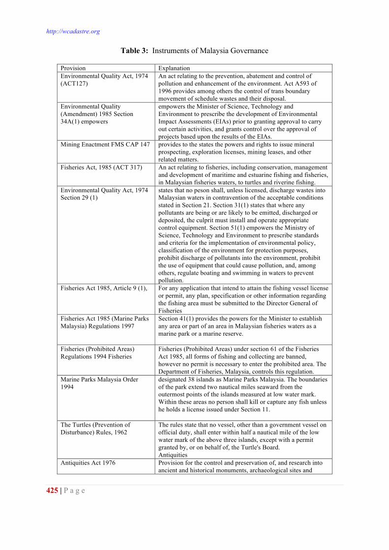
http://wcadastre.org
425 | P a g e
Table 3: Instruments of Malaysia Governance
Provision Explanation Environmental Quality Act, 1974 (ACT127)
An act relating to the prevention, abatement and control of pollution and enhancement of the environment. Act A593 of 1996 provides among others the control of trans boundary movement of schedule wastes and their disposal.
Environmental Quality (Amendment) 1985 Section 34A(1) empowers
empowers the Minister of Science, Technology and Environment to prescribe the development of Environmental Impact Assessments (EIAs) prior to granting approval to carry out certain activities, and grants control over the approval of projects based upon the results of the EIAs.
Mining Enactment FMS CAP 147 provides to the states the powers and rights to issue mineral prospecting, exploration licenses, mining leases, and other related matters.
Fisheries Act, 1985 (ACT 317) An act relating to fisheries, including conservation, management and development of maritime and estuarine fishing and fisheries, in Malaysian fisheries waters, to turtles and riverine fishing.
Environmental Quality Act, 1974 Section 29 (1)
states that no peson shall, unless licensed, discharge wastes into Malaysian waters in contravention of the acceptable conditions stated in Section 21. Section 31(1) states that where any pollutants are being or are likely to be emitted, discharged or deposited, the culprit must install and operate appropriate control equipment. Section 51(1) empowers the Ministry of Science, Technology and Environment to prescribe standards and criteria for the implementation of environmental policy, classification of the environment for protection purposes, prohibit discharge of pollutants into the environment, prohibit the use of equipment that could cause pollution, and, among others, regulate boating and swimming in waters to prevent pollution.
Fisheries Act 1985, Article 9 (1), For any application that intend to attain the fishing vessel license or permit, any plan, specification or other information regarding the fishing area must be submitted to the Director General of Fisheries
Fisheries Act 1985 (Marine Parks Malaysia) Regulations 1997
Section 41(1) provides the powers for the Minister to establish any area or part of an area in Malaysian fisheries waters as a marine park or a marine reserve.
Fisheries (Prohibited Areas) Regulations 1994 Fisheries
Fisheries (Prohibited Areas) under section 61 of the Fisheries Act 1985, all forms of fishing and collecting are banned, however no permit is necessary to enter the prohibited area. The Department of Fisheries, Malaysia, controls this regulation.
Marine Parks Malaysia Order 1994
designated 38 islands as Marine Parks Malaysia. The boundaries of the park extend two nautical miles seaward from the outermost points of the islands measured at low water mark. Within these areas no person shall kill or capture any fish unless he holds a license issued under Section 11.
The Turtles (Prevention of Disturbance) Rules, 1962
The rules state that no vessel, other than a government vessel on official duty, shall enter within half a nautical mile of the low water mark of the above three islands, except with a permit granted by, or on behalf of, the Turtle's Board. Antiquities
Antiquities Act 1976 Provision for the control and preservation of, and research into ancient and historical monuments, archaeological sites and
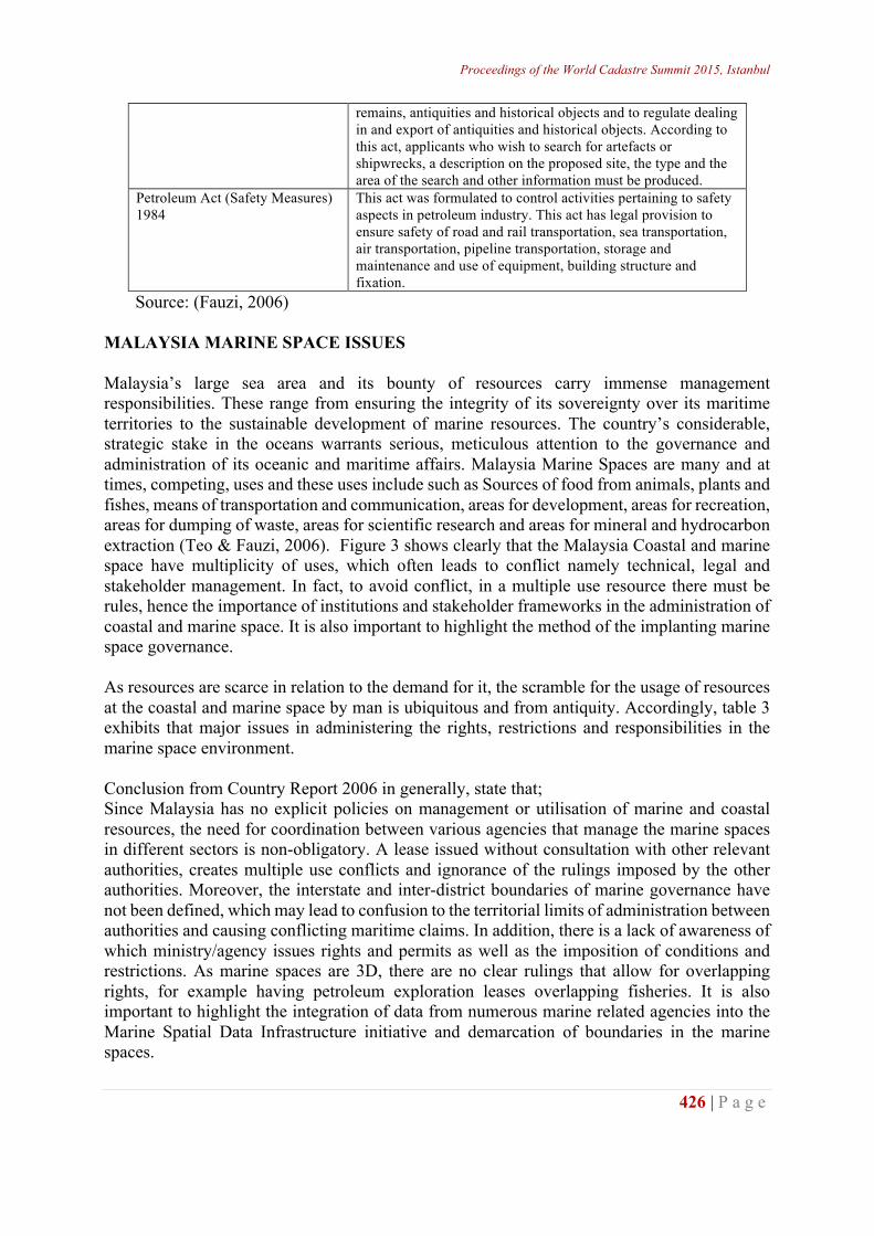
Proceedings of the World Cadastre Summit 2015, Istanbul
426 | P a g e
remains, antiquities and historical objects and to regulate dealing in and export of antiquities and historical objects. According to this act, applicants who wish to search for artefacts or shipwrecks, a description on the proposed site, the type and the area of the search and other information must be produced.
Petroleum Act (Safety Measures) 1984
This act was formulated to control activities pertaining to safety aspects in petroleum industry. This act has legal provision to ensure safety of road and rail transportation, sea transportation, air transportation, pipeline transportation, storage and maintenance and use of equipment, building structure and fixation.
Source: (Fauzi, 2006) MALAYSIA MARINE SPACE ISSUES Malaysia’s large sea area and its bounty of resources carry immense management responsibilities. These range from ensuring the integrity of its sovereignty over its maritime territories to the sustainable development of marine resources. The country’s considerable, strategic stake in the oceans warrants serious, meticulous attention to the governance and administration of its oceanic and maritime affairs. Malaysia Marine Spaces are many and at times, competing, uses and these uses include such as Sources of food from animals, plants and fishes, means of transportation and communication, areas for development, areas for recreation, areas for dumping of waste, areas for scientific research and areas for mineral and hydrocarbon extraction (Teo & Fauzi, 2006). Figure 3 shows clearly that the Malaysia Coastal and marine space have multiplicity of uses, which often leads to conflict namely technical, legal and stakeholder management. In fact, to avoid conflict, in a multiple use resource there must be rules, hence the importance of institutions and stakeholder frameworks in the administration of coastal and marine space. It is also important to highlight the method of the implanting marine space governance. As resources are scarce in relation to the demand for it, the scramble for the usage of resources at the coastal and marine space by man is ubiquitous and from antiquity. Accordingly, table 3 exhibits that major issues in administering the rights, restrictions and responsibilities in the marine space environment. Conclusion from Country Report 2006 in generally, state that; Since Malaysia has no explicit policies on management or utilisation of marine and coastal resources, the need for coordination between various agencies that manage the marine spaces in different sectors is non-obligatory. A lease issued without consultation with other relevant authorities, creates multiple use conflicts and ignorance of the rulings imposed by the other authorities. Moreover, the interstate and inter-district boundaries of marine governance have not been defined, which may lead to confusion to the territorial limits of administration between authorities and causing conflicting maritime claims. In addition, there is a lack of awareness of which ministry/agency issues rights and permits as well as the imposition of conditions and restrictions. As marine spaces are 3D, there are no clear rulings that allow for overlapping rights, for example having petroleum exploration leases overlapping fisheries. It is also important to highlight the integration of data from numerous marine related agencies into the Marine Spatial Data Infrastructure initiative and demarcation of boundaries in the marine spaces.
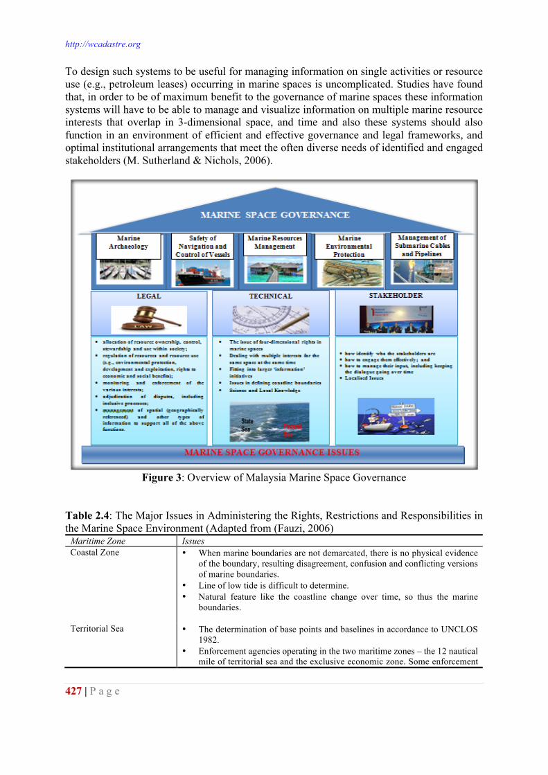
http://wcadastre.org
427 | P a g e
To design such systems to be useful for managing information on single activities or resource use (e.g., petroleum leases) occurring in marine spaces is uncomplicated. Studies have found that, in order to be of maximum benefit to the governance of marine spaces these information systems will have to be able to manage and visualize information on multiple marine resource interests that overlap in 3-dimensional space, and time and also these systems should also function in an environment of efficient and effective governance and legal frameworks, and optimal institutional arrangements that meet the often diverse needs of identified and engaged stakeholders (M. Sutherland & Nichols, 2006).
Figure 3: Overview of Malaysia Marine Space Governance
Table 2.4: The Major Issues in Administering the Rights, Restrictions and Responsibilities in the Marine Space Environment (Adapted from (Fauzi, 2006)
Maritime Zone Issues Coastal Zone • When marine boundaries are not demarcated, there is no physical evidence
of the boundary, resulting disagreement, confusion and conflicting versions of marine boundaries.
• Line of low tide is difficult to determine. • Natural feature like the coastline change over time, so thus the marine
boundaries.
Territorial Sea • The determination of base points and baselines in accordance to UNCLOS 1982.
• Enforcement agencies operating in the two maritime zones – the 12 nautical mile of territorial sea and the exclusive economic zone. Some enforcement
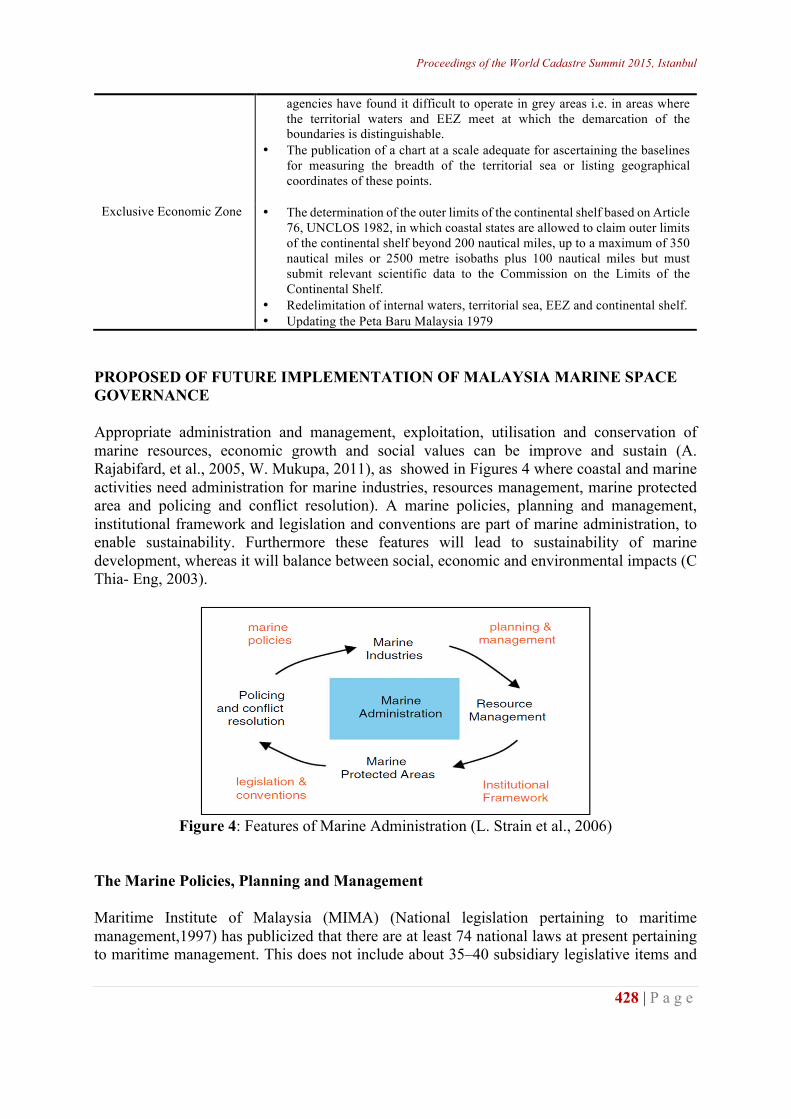
Proceedings of the World Cadastre Summit 2015, Istanbul
428 | P a g e
agencies have found it difficult to operate in grey areas i.e. in areas where the territorial waters and EEZ meet at which the demarcation of the boundaries is distinguishable.
• The publication of a chart at a scale adequate for ascertaining the baselines for measuring the breadth of the territorial sea or listing geographical coordinates of these points.
Exclusive Economic Zone • The determination of the outer limits of the continental shelf based on Article 76, UNCLOS 1982, in which coastal states are allowed to claim outer limits of the continental shelf beyond 200 nautical miles, up to a maximum of 350 nautical miles or 2500 metre isobaths plus 100 nautical miles but must submit relevant scientific data to the Commission on the Limits of the Continental Shelf.
• Redelimitation of internal waters, territorial sea, EEZ and continental shelf. • Updating the Peta Baru Malaysia 1979
PROPOSED OF FUTURE IMPLEMENTATION OF MALAYSIA MARINE SPACE GOVERNANCE Appropriate administration and management, exploitation, utilisation and conservation of marine resources, economic growth and social values can be improve and sustain (A. Rajabifard, et al., 2005, W. Mukupa, 2011), as showed in Figures 4 where coastal and marine activities need administration for marine industries, resources management, marine protected area and policing and conflict resolution). A marine policies, planning and management, institutional framework and legislation and conventions are part of marine administration, to enable sustainability. Furthermore these features will lead to sustainability of marine development, whereas it will balance between social, economic and environmental impacts (C Thia- Eng, 2003).
Figure 4: Features of Marine Administration (L. Strain et al., 2006)
The Marine Policies, Planning and Management Maritime Institute of Malaysia (MIMA) (National legislation pertaining to maritime management,1997) has publicized that there are at least 74 national laws at present pertaining to maritime management. This does not include about 35–40 subsidiary legislative items and
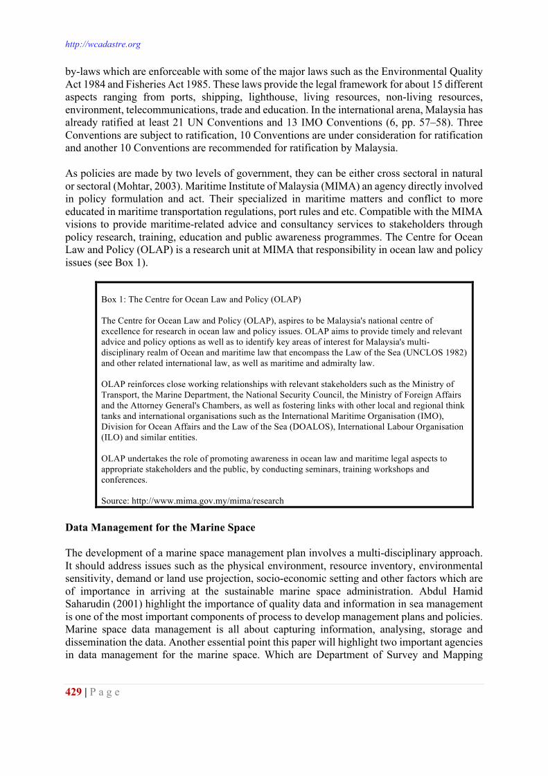
http://wcadastre.org
429 | P a g e
by-laws which are enforceable with some of the major laws such as the Environmental Quality Act 1984 and Fisheries Act 1985. These laws provide the legal framework for about 15 different aspects ranging from ports, shipping, lighthouse, living resources, non-living resources, environment, telecommunications, trade and education. In the international arena, Malaysia has already ratified at least 21 UN Conventions and 13 IMO Conventions (6, pp. 57–58). Three Conventions are subject to ratification, 10 Conventions are under consideration for ratification and another 10 Conventions are recommended for ratification by Malaysia. As policies are made by two levels of government, they can be either cross sectoral in natural or sectoral (Mohtar, 2003). Maritime Institute of Malaysia (MIMA) an agency directly involved in policy formulation and act. Their specialized in maritime matters and conflict to more educated in maritime transportation regulations, port rules and etc. Compatible with the MIMA visions to provide maritime-related advice and consultancy services to stakeholders through policy research, training, education and public awareness programmes. The Centre for Ocean Law and Policy (OLAP) is a research unit at MIMA that responsibility in ocean law and policy issues (see Box 1).
Box 1: The Centre for Ocean Law and Policy (OLAP) The Centre for Ocean Law and Policy (OLAP), aspires to be Malaysia's national centre of excellence for research in ocean law and policy issues. OLAP aims to provide timely and relevant advice and policy options as well as to identify key areas of interest for Malaysia's multi-disciplinary realm of Ocean and maritime law that encompass the Law of the Sea (UNCLOS 1982) and other related international law, as well as maritime and admiralty law. OLAP reinforces close working relationships with relevant stakeholders such as the Ministry of Transport, the Marine Department, the National Security Council, the Ministry of Foreign Affairs and the Attorney General's Chambers, as well as fostering links with other local and regional think tanks and international organisations such as the International Maritime Organisation (IMO), Division for Ocean Affairs and the Law of the Sea (DOALOS), International Labour Organisation (ILO) and similar entities. OLAP undertakes the role of promoting awareness in ocean law and maritime legal aspects to appropriate stakeholders and the public, by conducting seminars, training workshops and conferences. Source: http://www.mima.gov.my/mima/research
Data Management for the Marine Space The development of a marine space management plan involves a multi-disciplinary approach. It should address issues such as the physical environment, resource inventory, environmental sensitivity, demand or land use projection, socio-economic setting and other factors which are of importance in arriving at the sustainable marine space administration. Abdul Hamid Saharudin (2001) highlight the importance of quality data and information in sea management is one of the most important components of process to develop management plans and policies. Marine space data management is all about capturing information, analysing, storage and dissemination the data. Another essential point this paper will highlight two important agencies in data management for the marine space. Which are Department of Survey and Mapping
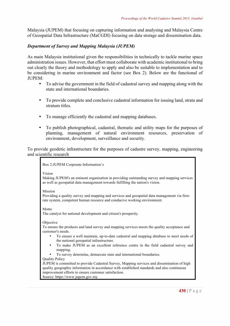
Proceedings of the World Cadastre Summit 2015, Istanbul
430 | P a g e
Malaysia (JUPEM) that focusing on capturing information and analysing and Malaysia Centre of Geospatial Data Infrastructure (MaCGDI) focusing on data storage and dissemination data. Department of Survey and Mapping Malaysia (JUPEM) As main Malaysia institutional given the responsibilities in technically to tackle marine space administration issues. However, that effort must collaborate with academic institutional to bring out clearly the theory and methodology to apply and also be suitable to implementation and to be considering in marine environment and factor (see Box 2). Below are the functional of JUPEM:
• To advise the government in the field of cadastral survey and mapping along with the state and international boundaries.
• To provide complete and conclusive cadastral information for issuing land, strata and
stratum titles.
• To manage efficiently the cadastral and mapping databases.
• To publish photographical, cadastral, thematic and utility maps for the purposes of planning, management of natural environment resources, preservation of environment, development, surveillance and security.
To provide geodetic infrastructure for the purposes of cadastre survey, mapping, engineering and scientific research
Box 2:JUPEM Corporate Information’s Vision Making JUPEM's an eminent organisation in providing outstanding survey and mapping services as well as geospatial data management towards fulfilling the nation's vision. Mission Providing a quality survey and mapping and services and geospatial data management via first-rate system, competent human resource and conducive working environment. Motto The catalyst for national development and citizen's prosperity. Objective To ensure the products and land survey and mapping services meets the quality acceptance and customer's needs.
• To ensure a well maintain, up-to-date cadastral and mapping database to meet needs of the national geospatial infrastructure.
• To make JUPEM as an excellent reference centre in the field cadastral survey and mapping.
• To survey determine, demarcate state and international boundaries. Quality Policy JUPEM is committed to provide Cadastral Survey, Mapping services and dissemination of high quality geographic information in accordance with established standards and also continuous improvement efforts to ensure customer satisfaction. Source: https://www.jupem.gov.my
http://wcadastre.org
431 | P a g e
Malaysian Centre for Geospatial Data Infrastructure (McGDI) Malaysia Geospatial Data Infrastructure (MyGDI) is an initiative by the government to develop a geospatial data infrastructure to enhance the awareness about data availability and improve access to geospatial information. This can be fulfilled by facilitating data sharing among participating agencies. MyGDI as the National Spatial Data Infrastructure (NSDI) for Malaysia, is a national infrastructure comprises of policy, data, standard, geospatial information and technology, R&D and development of human capital established by MyGDI Circular Letter no. 1 of 2006 – Guidelines for the Implementation of Malaysia Geospatial Data Infrastructure (MyGDI) for the purpose of facilitating the sharing and dissemination of geospatial information amongst government agencies, private sector and the general publics. Through this infrastructure, smart partnerships among agencies is continuously being developed to produce and share geospatial information thus providing customer-focused, cost effective and timely delivery of geospatial data. (MaCGDI) is a centre established by the government to manage and promote the development of geospatial data infrastructure for Malaysia (MyGDI). MaCGDI is also responsible for coordinating access and delivery of the geospatial information held by all government agencies. MaCGDI was established in December 2002 to replace the NaLIS Secretariat under the Minstry of Land and Cooperative Development (MLCD). On the 27th March 2004, MaCGDI was subsumed under the Ministry of Natural Resources and Environment (NRE). The main role of the centre is to continuously make available and accessible current and accurate geospatial data that promotes a sustainable living environment, economic growth and social progress for public. MaCGDI is organised with thirteen (13) sections and is set out to carry the following objectives: • To provide mechanism/infrastructure in supporting the usage and sharing of current,
accurate and reliable geospatial information among agencies by employing the latest geospatial techologies; and
• To avoid redundancy of duplicating efforts in collecting, processing, maintaining, providing and dissemination of required geospatial information.
The goal of MyGDI is to enable members of the geospatial communities in Malaysia to share and access geospatial data together seamlessly (see Box 3). Through its application MyGDI Explorer, MyGDI facilitates online access to geospatial information as an effort to avoid duplication of effort especially in the collection of geospatial data. It provides a base for geospatial data exploration, evaluation, and application for users and data providers within all levels of government, commercial, and non-profit sectors as well as the academia and the public. MyGDI governs through its committees and MaCGDI as the coordinator. In the Malaysia contexts, SDI initiatives started from the national level and are expected to filter down to all the states and gradually to all local levels. Like other countries, apart from financial and skill resources which forbid comprehensive big-bang undertaking, are knowledge and agreement
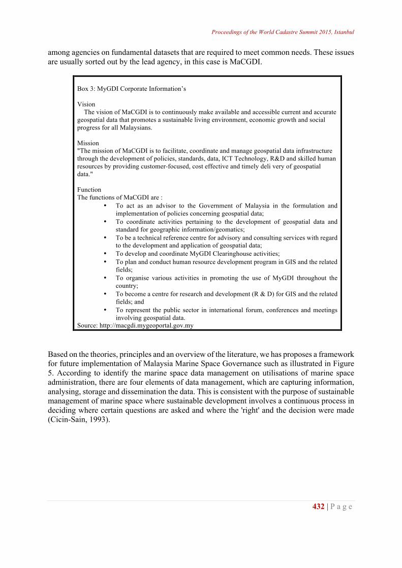
Proceedings of the World Cadastre Summit 2015, Istanbul
432 | P a g e
among agencies on fundamental datasets that are required to meet common needs. These issues are usually sorted out by the lead agency, in this case is MaCGDI.
Box 3: MyGDI Corporate Information’s Vision The vision of MaCGDI is to continuously make available and accessible current and accurate geospatial data that promotes a sustainable living environment, economic growth and social progress for all Malaysians. Mission "The mission of MaCGDI is to facilitate, coordinate and manage geospatial data infrastructure through the development of policies, standards, data, ICT Technology, R&D and skilled human resources by providing customer-focused, cost effective and timely deli very of geospatial data." Function The functions of MaCGDI are :
• To act as an advisor to the Government of Malaysia in the formulation and implementation of policies concerning geospatial data;
• To coordinate activities pertaining to the development of geospatial data and standard for geographic information/geomatics;
• To be a technical reference centre for advisory and consulting services with regard to the development and application of geospatial data;
• To develop and coordinate MyGDI Clearinghouse activities; • To plan and conduct human resource development program in GIS and the related
fields; • To organise various activities in promoting the use of MyGDI throughout the
country; • To become a centre for research and development (R & D) for GIS and the related
fields; and • To represent the public sector in international forum, conferences and meetings
involving geospatial data. Source: http://macgdi.mygeoportal.gov.my
Based on the theories, principles and an overview of the literature, we has proposes a framework for future implementation of Malaysia Marine Space Governance such as illustrated in Figure 5. According to identify the marine space data management on utilisations of marine space administration, there are four elements of data management, which are capturing information, analysing, storage and dissemination the data. This is consistent with the purpose of sustainable management of marine space where sustainable development involves a continuous process in deciding where certain questions are asked and where the 'right' and the decision were made (Cicin-Sain, 1993).
http://wcadastre.org
433 | P a g e
Table 3: Proposed Malaysia Marine Space Governance CUSTODIAN Prime Minister’s Office IMPLEMENTERS Department Of Director General Of Lands And Mines (FEDERAL) TECHNICAL SUPPORT & GEOSPATIAL DATA CENTRE Department of Survey and Mapping Malaysia (JUPEM) POLICIES SUPPORT Maritime Institute of Malaysia (MIMA) SPATIAL DATABASE INFRASTRUCTURE COORDINATOR Malaysia Centre of Geospatial Data Infrastructure (MaCGDI) USERS OF MARINE SPACE SERVICES International and Domestic Import and Export Community National Security Oil & Gas Sector Ports Freight Forwarders Supply Chain Managers Logistics Services Providers Maritime Support Service Providers FACILITATORS Ministry Of Transport Ministry of International Trade and Industry Ministry of Finance Royal Custom and Excise Department Ministry of Science and Technology Ministry of Agriculture and Agro-Based Industry Ministry of Natural Resources and Environment Ministry of Defence Ministry of Home Affairs Ministry of Culture, Arts and Tourism Ministry of Communication and Multimedia Ministry of Foreign Affairs Marine Department Financial Institutions and Insurers Legal and Arbitration and Technology Service Providers Ship Registers Classification Societies SUPPLIERS of MARINE SPACE SERVICES Ship Building and Ship Repairing Yards Shipbrokers Ship Management Companies Ship Owners Main Engine and Propulsion Manufacturers Land Transport Service Providers Warehouse Operators Aviation Companies SOURCES of HUMAN CAPITAL Maritime Academies and Technical Colleges Universities and Polytechnics Offering Courses in Marine Navigation, Engineering Oceanography, Supply Chain Management and Logistics
Modify: After Aziz Meo Ngah & Nazery Khalid (2014) Following list illustrates the Framework of Malaysia Marine Space Governance. They are eight key categories in the framework including detail parties involved namely:
Proceedings of the World Cadastre Summit 2015, Istanbul
434 | P a g e
• The Custodian of the marine space sector. Prime Ministers Department should be the lead agency to promote the development and oversee the growth of the sector, given its clout that can enable it to gather other agencies and parties involved in the maritime sector to work together (Aziz Meo Ngah & Nazery Khalid, 2014).
• The Implementers. These are parties that involved directly in marine space governance. All the activities should be under there are recommendations.
• The Technical Support & Geospatial Data Centre . Department of Survey and Mapping Malaysia (JUPEM) should lead agency in term of record activity above and under, maintaining and updating the marine space data. Again, Department of Survey and Mapping Malaysia (JUPEM) playing the role of data storage and dissemination. They would sit between the administration/management activities and the data, allowing any user access to appropriate data to support their needs.
• The Policies Support. Maritime Institute of Malaysia (MIMA) an agency directly involved in policy formulation and act. Their specialized in maritime matters and conflict to more educated in maritime transportation regulations, port rules and etc.
• The Spatial Database Infrastructure Coordinator. Malaysia Centre of Geospatial Data Infrastructure (MaCGDI) for the purpose of facilitating and responsible for coordinating the sharing and dissemination of geospatial information amongst government agencies, private sector and the general publics. Through this infrastructure, smart partnerships among agencies is continuously being developed to produce and share geospatial information thus providing customer-focused, cost effective and timely delivery of geospatial data.
• The Users of Marine Space Services. These are parties that use services in the marine space sectors such as shipping, port operations and shipyard services. Identifying them is an important step in managing the demand side of the maritime sector (Aziz Meo Ngah & Nazery Khalid, 2014).
• The Facilitators include government agencies involved in the marine space sector and support services providers in areas such as finance, ICT, legal, tax, consultancy, classification and registry (Aziz Meo Ngah & Nazery Khalid, 2014).
• The Providers of Marine Space Services. These are parties offering marine space services required by users (Aziz Meo Ngah & Nazery Khalid, 2014).
• The Sources of Human Capital, include maritime academies, universities, polytechnic and technical colleges providing marine space-related courses and programs (Aziz Meo Ngah & Nazery Khalid, 2014).
This framework show inter-related with and provides support to one another. According to Aziz Meo Ngah & Nazery Khalid, (2014) the custodian of the marine space, the regulatory authorities, industry players and users of marine space services are part of an ecosystem of marine space sector that features stakeholders working in harmony towards attaining common objective in a facilitating and pro-business and pro-investment environment towards sustainable. In such sustainable framework proposed, there is effective management of demand and supply sides of the marine space sector, supported by talented, skilled the human capital that matches the marine space governance needs and its rapid development and dynamic operating environment. CONCLUSION This research highlights the need of marine space governance seriously consider the issues that involved in role and responsibilities. By the introduction of the data management into the stakeholder management and organizational performance, the researchers propose to explain how role, responsibilities and data management in marine space administration can lead to successful sustainable marine space governance.
http://wcadastre.org
435 | P a g e
Role, responsibilities and data management, in the broad sense of the process by which stakeholder work together to accomplish a common mission is hence essential when stakeholder need to work together closely. Stakeholder must commonly agree on how they will manage the marine space administration functions of marine space tenure, marine space value, marine space-use and marine space development, and, equally important, on how they will make this information available to the wider society in order to encourage creativity, efficiency and productive development among citizens and businesses in a sustainable manner. Therefore, role, responsibilities and data management is functions an approach that must be embedded in the marine space governance. A future study investigating marine space stakeholder role, responsibilities and data management would be very interesting. ACKNOWLEDGEMENT The authors would like to express their gratitude to Ministry of Education ,Universiti Teknologi Malaysia (UTM), Jabatan Pengajian Politeknik (JPP) and Fundamental Research Grant Scheme (FRGS) – Ministry of Science, Technology and Innovation (MOSTI) for supporting, funding and contribution respectively. This research is funded by FRGS Fund Vot 4F402. REFERENCES Aziz Meor Ngah and Nazery Khalid, 2014. MIMA Bulletin. Maritime Institute of Malaysia (MIMA), pp.27–34. Calestino, A. B. 2001. Malaysia. Does it really need decentralization. In Sourcebook on decentralization in Asia.
Decentralization and power shift: An imperative for good governance, eds. A. B. Brillantes, Jr. and N. G. Cuachon, Manila: Asian Resource CenterFor Decentralization.
Cicin-Sain, B. (1993). Sustainable development and integrated coastal management. Ocean & Coastal Management, 21(1-3), 11–43. doi:10.1016/0964-5691(93)90019-U
Cockburn, S. (2005). Developments in Marine Boundary Law to Construct a Legal Framework for Offshore and Coastal Spaces. M.Sc.E. thesis, Department of Geodesy and Geomatics Engineering Technical Report No. 228, University of New Brunswick, Fredericton, New Brunswick, Canada, 132 pp.
Fauzi, A. (2006). Country Report 2006 (base on the Marine Administration Country Template 2004). Malaysia. Mokhtar, M. B., & Ghani Aziz, S. A. B. . (2003). Integrated coastal zone management using the ecosystems
approach, some perspectives in Malaysia. Ocean & Coastal Management, 46(5), 407–419. doi:10.1016/S0964-5691(03)00015-2
Ng’ang'a, S., Sutherland, M., Cockburn, S., & Nichols, S. (2004). Toward a 3D marine cadastre in support of good ocean governance: a review of the technical framework requirements. Computers, Environment and Urban Systems, 28(5), 443–470. doi:10.1016/j.compenvurbsys.2003.11.002
Ramli, J. (1999). A New Maritime Legal Regime for Malaysia Within the Context of Ocean Governance, 16–17. Saharuddin, A. H. (2001). National ocean policy—new opportunities for Malaysian ocean development. Marine
Policy, 25(6), 427–436. doi:10.1016/S0308-597X(01)00027-6 Saw, I., Seang, H., Ziauddin, I., Latif, A., Pantai, B. K., & Pengairan, J. (2002). 1 st Annual Seminar On
Sustainability Science And Management : Issues of The Coastal Zone 6-8 May 2002 Kuala Terengganu Future Management Of Shoreline Area Through Integrated Shoreline Management Plan By, (May).
Strain, L., Rajabifard, A., & Williamson, I. (2006). Marine administration and spatial data infrastructure. Marine Policy, 30(4), 431–441. doi:10.1016/j.marpol.2005.03.005
Suzanne Bass et al. (2006). Marine Managed Areas : Best Practices for Boundary Making. (N. C. S. C. Gerald G. Esch, Ed.). 2234 South Hobson Avenue Charleston, SC 29405-2413 (843) 740-1200: NOAA Coastal Services Center.
Teo, C. H., & Fauzi, A. (2006). A National Geocentric Datum and the Administration of Marine Spaces in Malaysia 2. In FIG PUBLICATION NO 36.
Mukupa, W. (2011). Land Administration to Support Sustainable Development. FIG Working Week 2011. Morocco.C Thia-Eng, S. B., M San (2003). Coastal and Ocean Governance of the Seas of East Asia: Towards an Era of New Regional Cooperation and Partnerships. Tropical Coasts.
Web Page: (URL-1, <: http://www.mima.gov.my/mima/research >, 16.10.2014) Web Page: (URL-1, <: http:// https://www.jupem.gov.my >, 16.10.2014) Web Page: (URL-1, <: https://www.jupem.gov.my >, 16.10.2014)