persatuan geologi malaysia · the salak ridge and bukit gasing. the total width of the kuala lumpur...
TRANSCRIPT
ISSN 0126-5539
PERSATUAN GEOLOGI MALAYSIA
NEWSLETTER OF THE GEOLOGICAL SOCIETY OF MALAYSIA
KANDUNGAN (Contents) CATATAN GEOLOGI (Geological Notes)
H.D. Tjia: The Kuala Lumpur fault zone revisited 225
Umar bin· Hamzah, Haryono, Abdul Rahim Samsudin, Abdul Ghani Rafek 231 and Che Aziz Ali: High resolution multichannel seismic profiling: a case study at Pak Pura, Bachok, Kelantan
PERTEMUAN PERSATUAN (Meetings of the Society)
Peter J . Cook: The role ofthe geological surveys in the 21st Century 239
Joseph J. Lambiase: Sedimentation, stratigraphy and hyrocarbon potential 241 in continental rift basins
G.R. 8hi: Terrane rafting enhanced by contemporaneous climatic 243 amelioration as a mechanism of biogeographical vicariance: Permian marine biogeography of SE Asia
G.R. 8hi: Early Permian brachiopods from the Singa Formation of Langkawi 243 Island, northwestern Peninsular Malaysia: biostratigraphical and biogeographical implications
Matthew Rajah: Geology and its impact on the environment 245
BERITA-BERITA PERSATUAN (News of the Society)
Keahlian (Membership)
Pertukaran Alamat (Change of Address)
Pertambahan Baru Perpustakaan (New Library Additions)
BERITA-BERITA LAIN (Other News)
Local News
Obituary - Dr. Jaafar bin Ahmad
Gas Habitats of 8E Asia & Australasia
Kalendar (Calendar)
247
248
248
249
273
274
275
-
Majlis (Council) 1997/98
Presiden (President) N aib Presiden (Vice-President) Setiausaha (Secretary) Penolong Setiausaha (Asst. Secretary) Bendahari (Treasurer) Pengarang (Editor)
Khalid Ngah Khoo Kay Khean Ahmad Tajuddin Ibrahim S. Paramananthan Lee Chai Peng TehGuanHoe
Presiden Yang Dahulu (Immediate Past President) : Fateh Chand
19.97-99
Ahli-Ahli Majlis (Councillors)
1997-98
Tan B<;:>on Kong Azhar Hussin KK Liew Kadderi Md. Desa
Abd. Ghani Mohd Rafek Abdul Rahim Samsudin Abdul Hadi Abd. Rahman Sia Hok Kiang
Joawatankuasa Kecil Pengarang (Editorial Subcommittee)
Teh Guan Hoe (Pengerusi/Chairman)
Fan Ah Kwai Ng Thain Fatt J .J . Pereira
Lembaga Penasihat Pengo rang (Editorial Advisory Board)
Aw Peck Chin Foo Wah Yang Mazlan Madon P.H. Stauffer Azhar Hj. Hussin C.A. Foss Ian Metcalfe Tan Boon Kong KR. Chakraborty N.S. Haile S. Paramananthan Tan Teong Ring Choo Mun Keong C.S. Hutchison John Kuna Raj Teoh Lay Hock Chu Leng Heng Lee Chai Peng Senathi Rajah H.D. Tjia Denis N.K Tan Leong Lap Sau Shu Yeoh Khoon Yeap Cheng Hock
About the Society
The Society was founded in 1967 with the aim of promoting the advancement of earth sciences particularly in Malaysia and the Southeast Asian region.
The Society has a membership of about 600 earth scientists interested in Malaysia and other Southeast Asian regions. The membership is worldwide in distribution.
Published by the Geological Society of Malaysia , Department of Geology, University of Malaya, 50603 Kuala Lumpur. Tel: 603-757 7036 Fax: 603-7563900 E-mail: [email protected]
Printed by Art Printing Works Sdn. Bhd. , 29 Jolon Riong, 59700 Kuala Lumpur.
The Kuala Lumpur fault zone revisited
H.D. TJIA
Petronas Research & Scientific Services Sdn. Bhd. Lot 1026 PKNS Industrial Estate
54200 Rulu Kelang
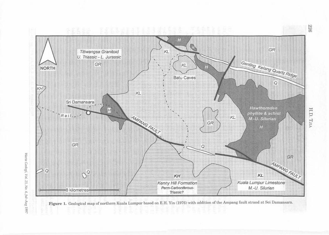
Since Stauffer (1968) and Shu (1969) proposed and highlighted the WNW -striking faults across Kuala Lumpur to possess leftlateral displacement, the structure has become established in the geological literature. Total displacement was estimated at about 20 km on the basis of offsets of geological boundaries. The so-called Kuala Lumpur fault zone consists of four major strands. The northern-most coincides with the Genting Kelang quartz ridge and about 7 km to its south lies the Ampang fault. The southern-most fault strand strikes east-west and has been placed to coincide with the Salak ridge and Bukit Gasing. The total width of the Kuala Lumpur fault zone is about 15 km. At Sri Damansara (coordinates: 05°11'55"N, 10P37'05"E) on the trunk road between Kepong and Sungai Buluh, a splay of the Ampang fault strand is well exposed as sheared, porphyritic granitoid and as striated fault planes. On Yin's geological map of Kuala Lumpur (1976) the newly interpreted fault splay occurs within granitoid (Fig. 1).
This note draws attention to the various well-developed directional markings on six sets of major, very steeply inclined to subvertical fault planes in the granitoid. The directional markings are striations or grooves that are inclined subhorizontally or very often at angles not exceeding 15 degrees. In addition, markings that indicate sense of displacement consist of
Present Address: Petronas Research & Scientific Services Sdn. Bhd.
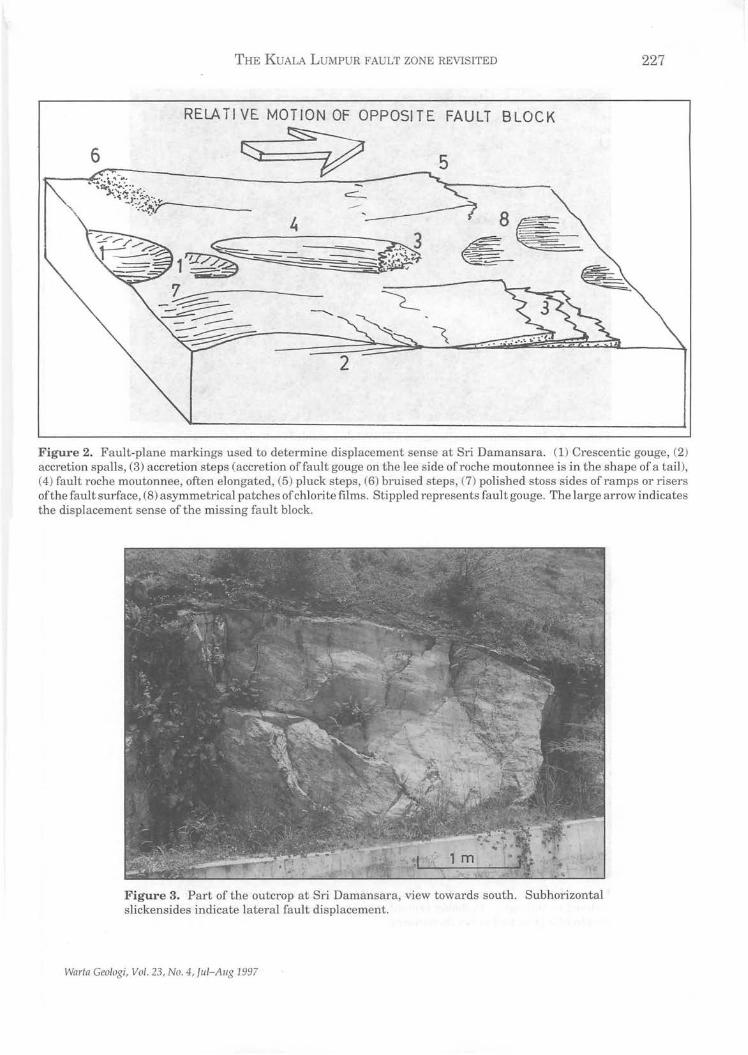
(1) crescentic gouge, (2) accretion spalls, (3) accretion steps, (4) fault roche moutonnees, (5) pluck steps, (6) bruised steps, (7) polished stosssides of knobs or of ramps of the fault plane, and (8) asymmetrical patches of chlorite films (Fig. 2). In my field experience, accretion spalls occur most commonly in gra~itoids. The photographs (Figs. 3 to 6) illustrate some of the above mentioned fault-plane markings.
The outcrop at Sri Damansara is in the lower part of a hill and faces north. The main fault set strikes 100°-105° which is the strike of the Kuala Lumpur fault zone. The other five fault sets strike North, NNE, ENE, ESE and SE (Fig. 7). The sense of displacement were determined by using the markings of Figure 2. The field readings offault-plane orientations and fault sense are plotted on an equal-area net, lower hemisphere (Fig. 8). With 2 rare exceptions the lateral sense offault displacement define a distinct sector of left-slip 114°-194° and a sector of right-slip 30°-100°. If all the fault slips in this outcrop developed in the same stress system, the maximum principal stress of that system acted horizontally and was orientated 100°-114° to 280°-294°.
Field and radiometric evidence strongly suggest that in Peninsular Malaysia tectonic fault activity ceased by the mid-Eocene. The Kuala Lumpur fault zone can also be regarded as inactive. A strike-slip fault zone is commonly
Lots 3288 & 3289, Kawasan Institusi Bangi, 43000 Bangi.
ISSN 01 26-5539 Warta Geologi, Vol. 23, No.4, Jtd- Aug 1997, pp. 225-230
Titiwangsa Granitoid Triassic - L. Jurassic
I II
Triassic?
Figure 1. Geological map of northern Kuala Lumpur based on E.H. Yin (1976) with addition of the Ampang fault strand at Sei Damansara.
THE KUALA LUMPUR FAULT ZONE REVISITED 227
RELA T I VE MOT ION OF OPPOSI T E FAULT BLOCK
6 ~ 5
2
Figure 2. Fault-plane markings used to determine displacement sense at Sri Damansara. (1) Crescentic gouge, (2) accretion spalls, (3) accretion steps (accretion offault gouge on the lee side of roche moutonnee is in the shape of a tail), (4) fault roche moutonnee, often elongated, (5) pluck steps, (6) bruised steps, (7) polished stoss sides of ramps or risers of the fault surface, (8) asymmetrical patches of chlorite films. Stippled represents fault gouge. The large arrow indicates the displacement sense of the missing fault block.
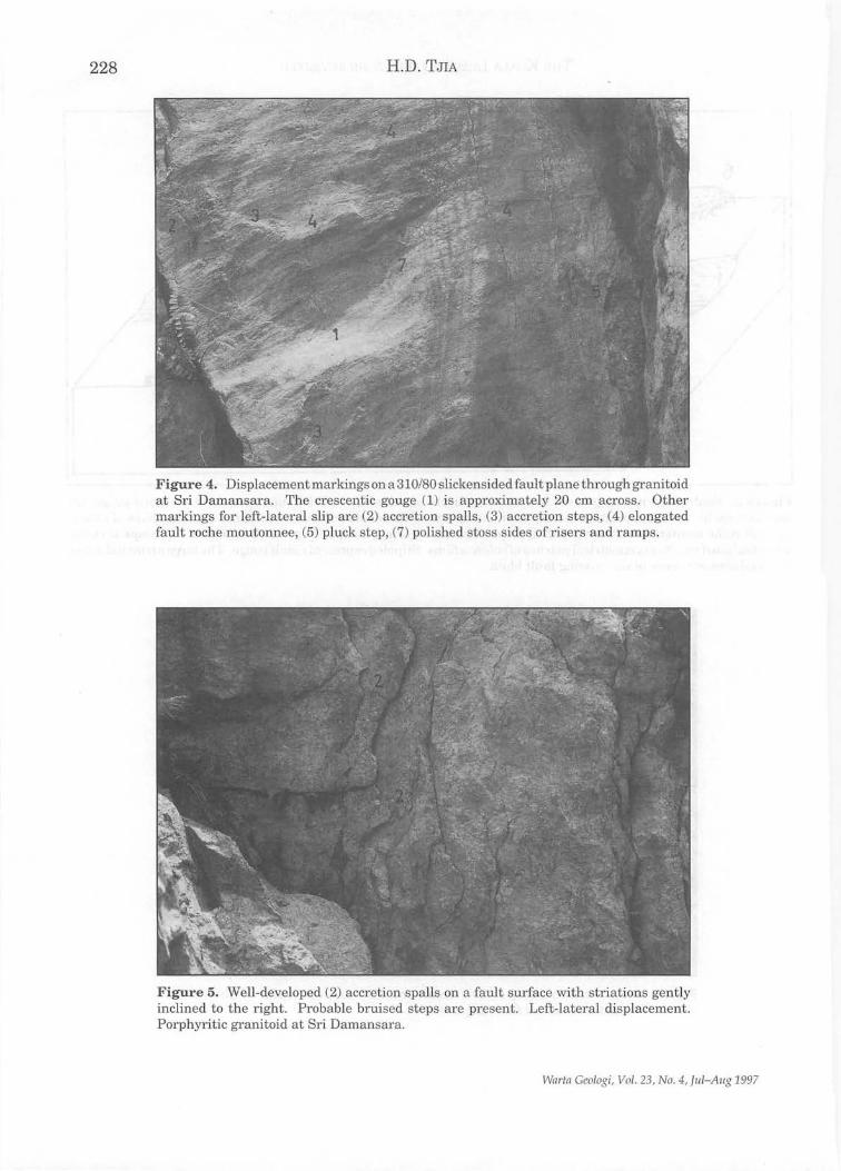
Figure 3. Part of the outcrop at Sri Damansara, view towards south. Subhorizontal slickensides indicate lateral fault displacement.
Warta Geologi, Vol. 23, No.4, JIlI-AlIg 1997
228 H.D. TJIA
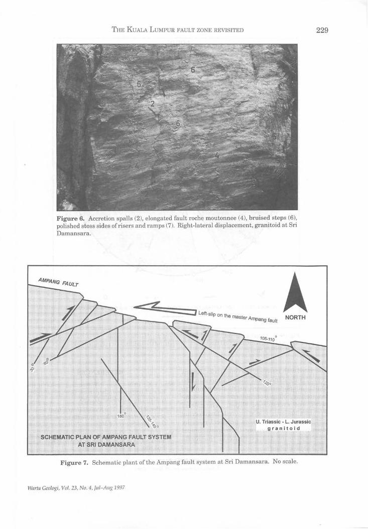
Figure 4. Displacement markings on a 310/80 slickensided fault plane through granitoid at Sri Damansara. The crescentic gouge (1) is approximately 20 cm across. Other markings for left-lateral slip are (2) accretion spalls, (3) accretion steps, (4) elongated fault roche moutonnee, (5) pluck step, (7) polished stoss sides of risers and ramps.
Figure 5. Well-developed (2) accretion spalls on a fault surface with striations gently inclined to the right. Probable bruised steps are present. Left-lateral displacement. Porphyritic granitoid at Sri Damansara.
Wnr/n Geologi, Vo l. 23, No.4 , Jul-Aug 1997
THE KUALA LUMPUR FAULT ZONE REVISITED
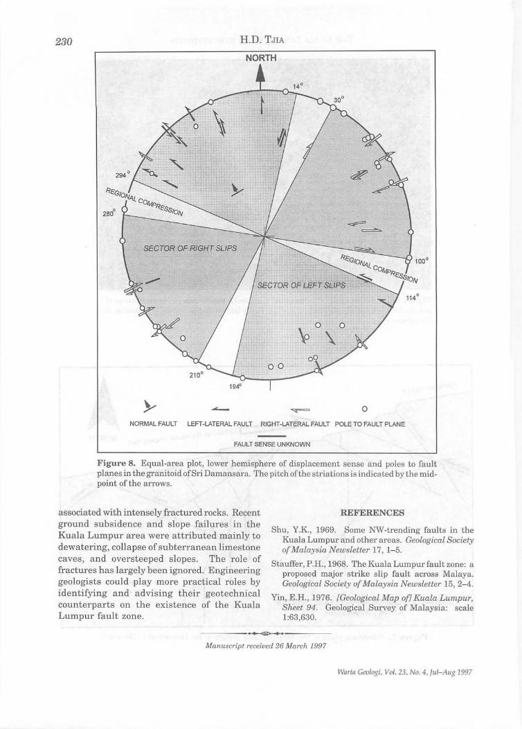
Figure 6. Accretion spalls (2), elongated fault roche moutonnee (4), bruised steps (6), polished stoss sides of risers and ramps (7). Right-lateral displacement, granitoid at Sri Damansara.
- .... -==::::=::=:~] left-slip on the m aster Ampang fault NORTH
Figure 7. Schematic plant ofthe Ampang fault system at Sri Damansara. No scale.
Wa,.ta Geologi, Vol. 23, No . 4, lul-Allg 1997
229
23() H.D. TJIA
NORTH
o NORMAL FAULT LEFT-LATERAL FAULT RIGHT-LATERAL FAULT POLE TO FAULT PLANE
FAULT SENSE UNKNOWN
Figure 8. Equal-area plot, lower hemisphere of displacement sense and poles to fault planes in the granitoid of Sri Damansara. The pitch ofthe striations is indicated by the midpoint of the arrows.
associated with intensely fractured rocks. Recent ground subsidence and slope failures in the Kuala Lumpur area were attributed mainly to dewatering, collapse of subterranean limestone caves, and oversteeped slopes. The role of fractures has largely been ignored. Engineering geologists could play more practical roles by identifying and advising their geotechnical counterparts on the existence of the Kuala Lumpur fault zone.
REFERENCES
Shu, YK., 1969. Some NW-trending faults in the Kuala Lumpur and other areas. Geological Society of Malaysia Newsletter 17, 1-5.
Stimffer, P.R., 1968. The Kuala Lumpurfault zone: a proposed major strike slip fault across Malaya. Geological Society of Malaysia Newsletter 15, 2-4.
Yin, E.R. , 1976. [Geological Map of] Kuala Lumpur, Sheet 94. Geological Survey of Malaysia: scale 1:63,630.
----------.~.~~,---------
Manuscript received 26 March 1997
Warta Geologi, Vol . 23, No.4, lui-Aug 1997
High resolution multichannel seismic profiling: a case study at Pak Pura, Bachok, Kelantan
UMAR BIN HAMZAH, HARYONO, ABDUL RAHIM SAMSUDIN, ABDUL GHANI RAFEK
AND eRE AzIZ ALI
J abatan Geologi Universiti Kebangsaan Malaysia
Bangi, Selangor D.E.
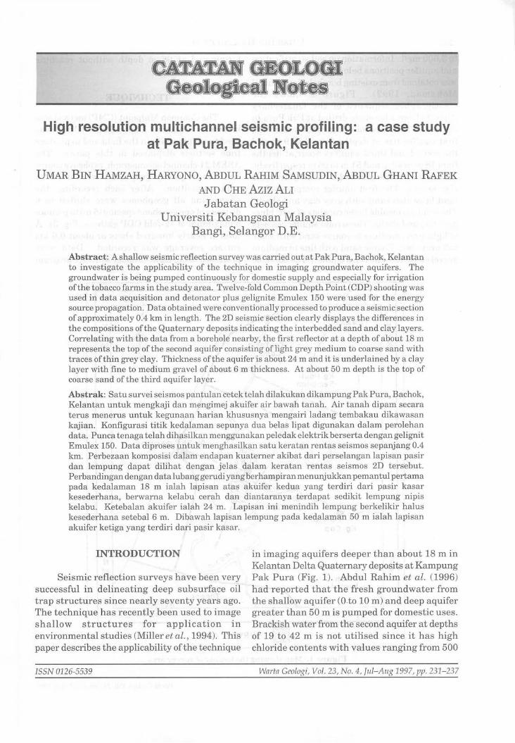
Abstract: A shallow seismic reflection survey was carried out at Pak Pura, Bachok, Kelantan to investigate the applicability of the technique in imaging groundwater aquifers. The groundwater is being pumped continuously for domestic supply and especially for irrigation ofthe tobacco farms in the study area. Twelve-fold Common Depth Point (CDP) shooting was used in data acquisition and detonator plus gelignite Emulex 150 were used for the energy source propagation. Data obtained were conventionally processed to produce a seismic section of approximately 0.4 km in length. The 2D seismic section clearly displays the differences in the compositions ofthe Quaternary deposits indicating the interbedded sand and clay layers . Correlating with the data from a borehole nearby, the first reflector at a depth of about 18 m represents the top ofthe second aquifer consisting of light grey medium to coarse sand with traces ofthin grey clay. Thickness of the aquifer is about 24 m and it is underlained by a clay layer with fine to medium gravel of about 6 m thickness . At about 50 m depth is the top of coarse sand of the third aquifer layer.
Abstrak: Satu survei seismos pantulan cetek telah dilakukan dikampung Pak Pura, Bachok, Kelantan untuk mengkaji dan mengimej akuifer air bawah tanah. Air tanah dipam secara terus menerus untuk kegunaan harian khususnya mengairi ladang tembakau dikawasan kajian. Konfigurasi titik kedalaman sepunya dua belas lipat digunakan dalam perolehan da tao Punca tenaga telah dihasilkan menggunakan peledak elektrik berserta dengan geligni t Emulex 150. Data diproses untuk menghasilkan satu keratan rentas seismos sepanjang 0.4 km. Perbezaan komposisi dalam endapan kuaterner akibat dari perselangan lapisan pasir dan lempung dapat dilihat dengan jelas dalam keratan rentas seismos 2D tersebut. Perbandingan dengan data lubang gerudiyang berhampiran menunjukkan pemantul pertama pada kedalaman 18 m ialah lapisan atas akuifer kedua yang terdiri dari pasir kasar kesederhana, berwarna kelabu cerah dan diantaranya terdapat sedikit lempung nipis kelabu. Ketebalan akuifer ialah 24 m. Lapisan ini menindih lempung berkelikir halus kesederhana setebal 6 m. Dibawah lapis an lempung pada kedalaman 50 m ialah lapisan akuifer ketiga yang terdiri dari pasir kasar.
INTRODUCTION
Seismic reflection surveys have been very successful in delineating deep subsurface oil trap structures since nearly seventy years ago. The technique has recently been used to image shallow structures for application in environmental studies (Miller et al., 1994). This paper describes the applicability ofthe technique
ISSN 0126-5539
in imaging aquifers deeper than about 18 m in Kelantan Delta Quaternary deposits at Kampung Pak Pur a (Fig. 1). Abdul Rahim et al. (1996) had reported that the fresh groundwater from the shallow aquifer (O .to 10 m) and deep aquifer greater than 50 m is pumped for domestic uses. Brackish water from the second aquifer at depths of 19 to 42 m is not utilised since it has high chloride contents with vaiues ranging from 500
Warta Geologi, Vol. 23, No.4, Jul-Aug 1997, pp. 231-237
232 UMAR BIN lIAMzAH ET AL.
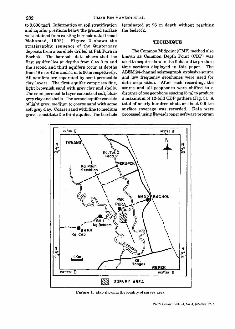
to 3,600 mg/l. Information on soil stratification and aquifer positions below the ground surface was obtained from existing borehole data.(lsmail Mohamad, 1992). Figure 2 shows the stratigraphic sequence of the Quaternary deposits from a borehole drilled at Pak Pura in Bachok. The borehole data shows that the first aquifer lies at depths from 0 to 9 m and the second and third aquifers occur at depths from 18 m to 42 m and 51 m to 96 m respectively. All aquifers are separated by semi-permeable clay layers. The first aquifer comprises fine, light brownish sand with grey clay and shells. The semi permeable layer consists of soft, bluegrey clay and shells. The second aquifer consists of light grey, medium to coarse sand with some soft grey clay. Coarse sand with fine to medium gravel constitute the third aquifer. The borehole
N 6°
05'
N 6° 01'
,..e. .... __ /BH I
___ ...... Kg.Beklam
BHIOI Kg.Cap
terminated at 96 m depth without reaching the bedrock.
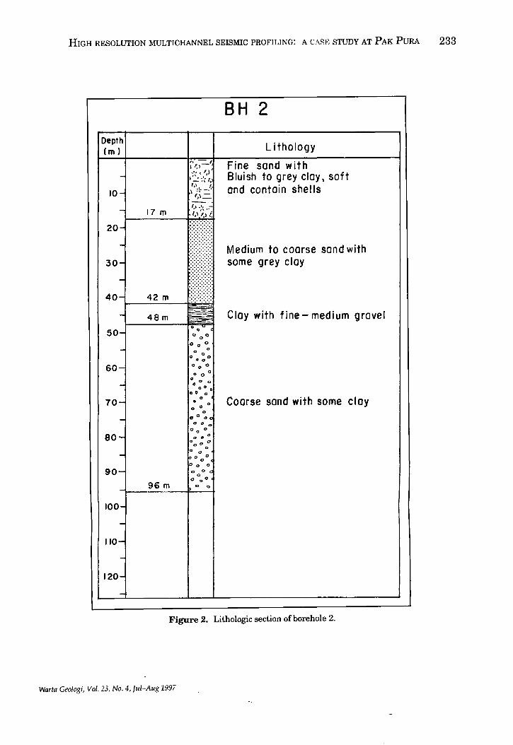
TECHNIQUE
The Common Midpoint (CMP) method also known as Common Depth Point (CDP) was used to acquire data in the field and to produce time sections displayed in this paper. The ABEM 24-channel seismograph, explosive source and low frequency geophones were used for data acquisition. After each recording, the source and all geophones were shifted to a distance of one geophone spacing (5 m) to produce a maximum of 12-fold CDP gathers (Fig. 3). A total of nearly hundred shots or about 0.6 km surface coverage was recorded. Data were processed using Eavesdropper software program
102°25 E
N
t N 6° 05'
~ SURVEY AREA
Figure 1. Map showing the locality of survey area.
Warta Geologi, Vol. 23, No.4, luI-Aug 1997
HIGH RESOLUTION MULTICHANNEL SEISMIC PROFILING: A CASE STUDY AT PAK PURA 233
Depth em)
-10-
-
50-
-60-
-70-
-80-
-90-
-100-
-110-
-120-
-
17 m
96 m
t, .' .. -;,\ '1.;';.
0 0 (
0 0 ° 0 0 0
o 0 o 0 0
00 0 0 0
00 0
°00 a o· •
00 0 o
• 0 o 0
o 0 0 0 ~ 00 0
0 0 0
o " 0
0 000° o " io 0 ,,0
0 0 0
0 00 <
" 0° o 0
BH 2
Lithology
Fine sand with Bluish to grey cloy \ soft and contain shells
Medium to coarse sand with some grey cloy
Cloy with fine - medium grovel
Coarse sand with some cloy
Figure 2. Lithologic section of borehole 2.
Warta Ceologi, Vol. 23, No.4, Jul-Aug 1997
t..:l ~
'- ~
i SURVEY --, )i
~ SPREAD 3 DIRECTION en
5~ ::r , 1 ,
, 0 SPREAD 2 9, 9'2 ~924 . I cT
§ 512 , , 1
\ SPREAD 1 9, o '2 ~924 ~
~ .', , , , 1 , ,
.g. •• • 9, 92 9 3 94 9 5 \
'" 0 ::s (1) rn ::h eo ~ d 8 ~~' ~ ~ SUBSURFACE \jj
~ Z ..... REFLECTING 0
~ ::s rn
8" .5, POINT 't:S 5 ~ C1 • ~
" 53 s:: 54 • t:t:l n
S..o.09~ (1) '. '"3
S "1:4 • ~ e- Oit'. • cT "1:('0 ~
~ g. ~O ~ ~ rn
i 0 ...., ~
n
I ~ FOLD ~ ::s -----.-.. --:- §. ~ .g. ~ 0 S Shot
.!I'" a 9 Geophone
~ (Jq
'I ~ ;:i:.
~ ~ .... !1' \J) \J) '-l
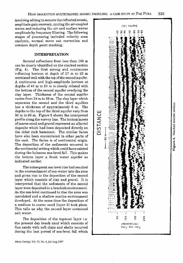
HIGH RESOLUTION MULTICHANNEL SEISMIC PROFILING: A CASE STUDY AT P AK PURA 235
involving editing to remove the refracted events, amplitude gain recovery, muting the air-coupled waves and reducing the air and surface waves amplitude by frequency filtering. The following stages of processing included velocity scan analysis, normal move out correction and common depth point stacking.
INTERPRETATION
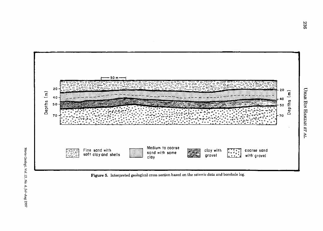
Several reflections from less than 100 m can be clearly identified on the stacked section (Fig. 4). The first strong and continuous reflecting horizon at depth of 17m to 23 m correlated well with the top ofthe second aquifer. A continuous and high-amplitude horizon at depths of 41 m to 51 m is closely related with the bottom of the second aquifer overlying the clay layer. Thickness of the second aquifer varies from 24 m to 28 m. The clay layer which separates the second and the third aquifers has a thickness of approximately 6 m. The depths to the top of the third aquifer vary from 50 m to 60 m. Figure 5 shows the interpreted profile along the survey line. The bottom layers of coarse sand and gravel represent an alluvial deposits which had been deposited directly on the older rock basement. The similar facies have also been encountered in other parts of the east. The facies is of continental origin. The deposition of the sediments occurred in the continental setting which could have existed during the holocene sea-level falL This makes the bottom layer a fresh water aquifer as indicated earlier.
The subsequent sea-level rise had resulted in the encroachment of sea-water into the area and given rise to the deposition of the second layer which consists of clay and graveL It is interpreted that the sediments of the second layer were deposited in a brackish environment. As the sea-level continued to rise the area was inundated and a shallow marine environment developed. At the same time the deposition of a medium to coarse sand (layer 2) took place. This tells us why the second layer contained salt water.
The deposition of the topmost layer i.e. the present day beach sand which consists of fine sands with soft clays and shells occurred during the last period of sea-level fall which
Warta Geologi, Vol. 23, No.4, lui-Aug 1997
w u z « I-
~ T o II')
1
(W) sludaa
o 00 0 N r<> v II')
I I I I
.' ... : i' ... j .... i' ... I o II')
o 0 o II')
(spuo:;as !I!W) awolI.0 ... -OM1
o o N
~ i3-
~ ~ .:-.
~ N ~
~ ~ ? ;C ~ ..... <0 <0 'J
20
E 40
en .c 50 .... a. Q.)
£:) 70
o 0 0 0 co 0 0°:'°40 : 0000 0 0 0 ° : °0 °00 0
°oo~O-ooQ::O:GOo-:;ooo:ooooooo o()OOOoooooo:o.:...~.!..o~~:-~ ...... -o-e--a 0 .. 0 ....Q. 0 0" 0 0" .. 0 0 0 0 0-20-,0"8'"' o. 0 0 0 0 <> 0 ,,-0 0 0 0 Co 0 "'1J -;, e-0--: 0 .. 0 0 .... 0 0 0 a 0 0 0 00'" 9..D 1: 0'0 0 0 0 ., 0 ~ <) 0
0 0 0 00",;'l4.. 0 Q 0 0 00 00 0 0 0 () 0 0 0 0 0 00 0 0 .. 0 0" 0 0 0 0 0 o'O""V-'" oti 0
:ooo:o:Qo_O_O 0 "00:: 00° oooooooo_ooo_o~o o:~oooo°c.aooooo~:: .... o 0°0°: 00 C) 000
II Fine sand with sof t cia y and shells
Medium to coarse sand with some clay
clay with gravel
Figure 5. Interpreted geological cross section based on the seismic data and borehole log.
20 E
40 en 50 ~
a. Q.)
70 Cl
coarse sand with gravel
t-J ~ en
e ~ to Z
[ ~ t;tj '""3
~
HIGH RESOLUTION MULTICHANNEL SEISMIC PROFILING: A CASE STUDY AT PAK PURA 237
took place about 5000 y B.P. (cf. Tjia, 1992). The deposition occurred progressively as the sea-level retreat to its present position. It is detected that the former coastline was about 10 km inland.
CONCLUSION
Shallow seismic reflection is a very effective technique for structural mapping especially in Quaternary deposits. In this study, the topographic variations of aquifers deeper than 20 m has been successfully determined within an accuracy of approximately one meter. The shallow aquifer located at 5 m depth unfortunately could not be detected by this technique.
ACKNOWLEDGEMENT
The authors wish to thank UKM for the research grant, En. Aminudin Mahmud from the Mines Research Institute for the explosive source handling and Lim Siew Teck for the data processing. Thanks to Assoc. Prof. Tan
Boon Kong for reading the manuscript.
REFERENCES
ABDUL RAHIM SAMSUDIN, IIARYONO, UMAR HAMZAH AND
ABDUL GHANI RAFEK, 1996. Salinity study of the groundwater in coastal aquifers ofN orth Kelantan, Malaysia. Proceeding of the International Symposium on Geology & Environment. University of Chiengmai, Thailand, 255-266.
ISMAIL MOHAMAD, 1992. Status pengawasan air tanah di Delta sungai Kelantan. Lapuran Persidangan Geologi ke 23, Penyiasatan Kajibumi Malaysia no. 4.
MAYNE, W.H., 1962. Horizontal data stacking techniques. Supplement to Geophysics, 27, 927-937.
MILLER, R.D., DOLL, W.E., MEREY, C. AND BLACK, W.E., 1994. Applications of shallow high-resolution seismic reflection to environmental problems. Environmental Geosciences 1(1), 32-39.
TJIA, H.D.,1992. Holocene sea-level changes in the Malay-Thai Peninsula, a tectonically stable environment. Geol. Soc. Malaysia Bull. 31, 157-176.
---------.~.-~~.-.--------Manuscript received 7 April 1997
Warta Geologi, Vol. 23, No.4, lui-Aug 1997
Geological Evolution of South-East Asia
CHARLES S. HUTCmSON
GEOLOGICAL SOCIETY OF MALAYSIA
SPECIAL LOW-PRICED SOFT-COVER EDITION LIMITED STOCK! GET YOUR COPY NOW!
Member RM50.00 PRICE: Non-Member : RMIOO.OO
Student Member : RM30.00 Cheques, Money Orders or Bank Drafts must accompany all orders. Orders will be invoiced for postage and bank charges. Orders should be addressed to:
The Hon. Assistant Secretary GEOLOGICAL SOCIETY OF MALAYSIA c/o Dept. of Geology, University of Malaya 50603 Kuala Lumpur, MALAYSIA
The role of the geological surveys in the 21st Century PETER J. COOK
Laporan (Report)
239
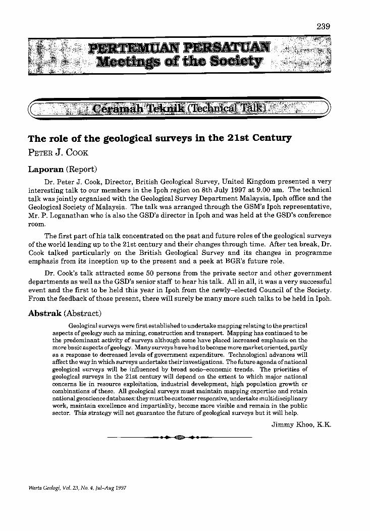
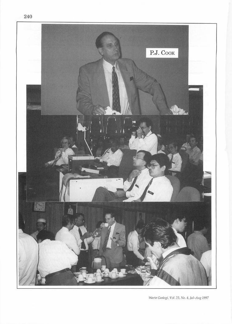
Dr. Peter J. Cook, Director, British Geological Survey, United Kingdom presented a very interesting talk to our members in the Ipoh region on 8th July 1997 at 9.00 am. The technical talk was jointly organised with the Geological Survey Department Malaysia, Ipoh office and the Geological Society of Malaysia. The talk was arranged through the GSM's Ipoh representative, Mr. P. Loganathan who is also the GSD's director in Ipoh and was held at the GSD's conference room.
The first part of his talk concentrated on the past and future roles ofthe geological surveys of the world leading up to the 21st century and their changes through time. After tea break, Dr. Cook talked particularly on the British Geological Survey and its changes in programme emphasis from its inception up to the present and a peek at BGR's future role.
Dr. Cook's talk attracted some 50 persons from the private sector and other government departments as well as the GSD's senior staff to hear his talk. All in all, it was a very successful event and the first to be held this year in Ipoh from the newly-elected Council of the Society. From the feedback ofthose present, there will surely be many more such talks to be held in Ipoh.
Abstrak (Abstract) Geological surveys were first established to undertake mapping relating to the practical
aspects of geology such as mining, construction and transport. Mapping has continued to be the predominant activity of surveys although some have placed increased emphasis on the more basic aspects of geology. Many surveys have had to become more market oriented, partly as a response to decreased levels of government expenditure. Technological advances will affect the way in which surveys undertake their investigations. The future agenda of national geological surveys will be influenced by broad socio-economic trends. The priorities of geological surveys in the 21st century will depend on the extent to which major national concerns lie in resource exploitation, industrial development, high population growth or combinations of these. All geological surveys must maintain mapping expertise and retain national geoscience databases: they must be customer responsive, undertake multidisciplinary work, maintain excellence and impartiality, become more visible and remain in the public sector. This strategy will not guarantee the future of geological surveys but it will help.
Jimmy Khoo, K.K.
-------------.~.~.--~~.~.-.-------------
Warta Ceologi, Vol. 23, No.4, Jul-Aug 1997
240
Wnrtn Geologi, Vol. 23, No. 4, ful-Aug 1997
Sedimentation, stratigraphy and hydrocarbon potential in continental rift basins JOSEPH J. LAMBIASE
Laporan (Report)
241
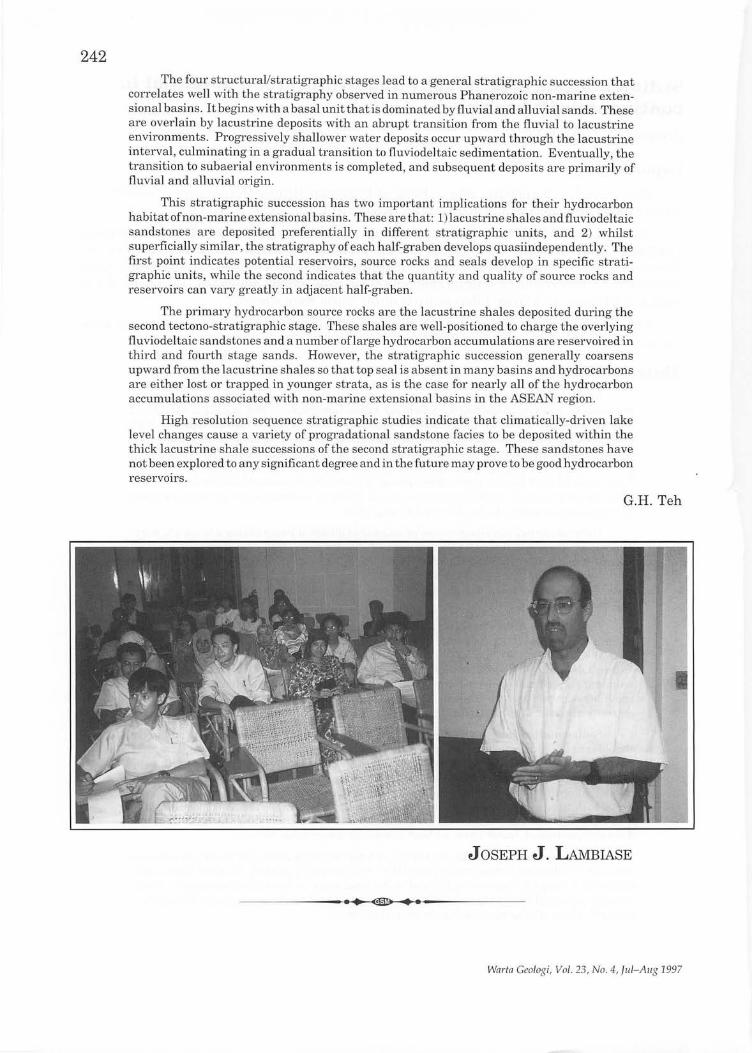
Prof. Joseph J. Lambiase, who is Head of Universiti Brunei Darussalam presented the above talk on July 15, 1997, at the Geology Department, University of Malaya.
The talk is an extended version of his keynote address at the recent Annual Geological Conference 1997 at Kijal, Terengganu. In his presentation which was well illustrated, he discussed the relationships between the structural development of continental rift basins, their sedimentation and resulting stratigraphy and their hydrocarbon potential. Examples of rift basins of different ages from different parts of the world were shown.
The talk attracted a large crowd of about 50, which included staff and students of local universities, and members from the oil industry.
Abstrak (Abstract)
Facies distributions in non-marine extensional basins are primarily the sedimentary response to evolving, tectonically-generated basin topography. Six principal structural features strongly influence sedimentation patterns. These are: 1) topographically high accommodation zones which segment the basins into discrete structural half-graben, 2) reactivation of pre-existing structural elements, 3) footwall uplift at main border faults, 4) gentle roll-over of topography on flexural margins, 5) breakup ofthe basin floor into elongate, basin-parallel fault blocks, and 6) development offault relay zones and transfer faults. Each of the six structural elements has its own specific affect on sedimentation, and consequently its own contribution to the basin's final stratigraphy.
Different structural elements are prominent at different times during a basin's history. There is a progression through four well-defined structural/stratigraphic stages, each with a specific structural morphology and associated facies distribution. Initially, riftparallel fault blocks and transfer faults are the most important structures and topographic reliefis limited. Sedimentation is dominated by fluvial processes; shallow lacustline and paludal sediments also can accumulate.
During the second stage, the rate of structurally-induced basin-floor subsidence and basin shoulder uplift exceeds the regional sedimentation rate. Accommodation zones, footwalls, and flexural margins become positive topographic features, resulting in a halfgraben morphology. The depositional patterns occur at the basin-wide scale, resulting in sediment starved half-graben. Large, deep lakes will develop in humid climatic settings and small lakes, rivers and deserts will dominate drier basins. On the basin floor, depositional patterns continue to be controlled by basin-parallel fault-blocks and transfer faults.
Sedimentation rate eventually overtakes the rate of basin-floor subsidence and basin shoulder uplift. Basin-floor topographic features such as individual fault blocks and transfer faults are buried. Accommodation zones and basin shoulder topography continue to define the basin margins and to influence sedimentation. Maximum water depth in lakes is limited by the height of the lowest basin-bounding topography, which forces a decrease in maximum depth with time as the basin fills. Generally, accommodation zones are the topographically lowest basin-bounding features and are the next to be buried, converting the basin floor to a fluvially-dominated, linear plain without along-axis topographic baniers.
Mter accommodation zones are buried, uplifted footwalls and flexural margin rollovers continue to influence sedimentation until they are ultimately eroded. In some basins, this erosion is a result of isostatic uplift and is the final stage in the basin's evolution. Other systems become thermal sag basins that continue to subside as broad, regional depocenters and still others ultimately undergo structural inversion.
Warta Geologi, Vol. 23, No.4, Jul-Aug 1997
242 The four structurallstratigraphic stages lead to a general stratigraphic succession that
correlates well with the stratigraphy observed in numerous Phanerozoic non-marine extensional basins. It begins with a basal unit that is dominated by fluvial and alluvial sands. These are overlain by lacustrine deposits with an abrupt transition from the fluvial to lacustrine environments. Progressively shallower water deposi.ts occur upward through the lacustrine interval, culminating in a gradual transition to fluviodeltaic sedimentation. Eventually, the transition to subaerial environments is completed, and subsequent deposits are primarily of fluvial and alluvial origin.
This stratigraphic succession has two important implications for their hydrocarbon habitat of non-marine extensional basins. These are that: 1) lacustrine shales and fluviodeltaic sandstones are deposited preferentially in different stratigraphic units, and 2) whilst superficially similar, the stratigraphy of each half-graben develops quasiindependently. The first point indicates potential reservoirs, source rocks and seals develop in specific stratigraphic units, while the second indicates that the quantity and quality of source rocks and reservoirs can vary greatly in adjacent half-graben.
The primary hydrocarbon source rocks are the lacustrine shales deposited during the second tectono-stratigraphic stage. These shales are well-positioned to charge the overlying flu viodeltaic sandstones and a number oflarge hydrocarbon accumulations are reservoired in third and fourth stage sands. However, the stratigraphic succession generally coarsens upward from the lacustrine shales so that top seal is absent in many basins and hydrocarbons are either lost or trapped in younger strata, as is the case for nearly all of the hydrocarbon accumulations associated with non-marine extensional basins in the ASEAN region.
High resolution sequence stratigraphic studies indicate that climatically-driven lake level changes cause a variety of progradational sandstone facies to be deposited within the thick lacustr ine shale successions of the second stratigraphic stage. These sandstones h ave not been explored to any significant degree and in the future may prove to be good hydrocarbon reservoirs.
G.H. Teh
JOSEPH J. LAMBIASE
------------___ .H .... ~~~ __ ------------
Warln Geologi, Vol. 23, No.4, lul- Allg 1997
243
Terrane rafting enhanced by contemporaneous climatic amelioration as a mechanism of biogeographical vicariance: Permian marine biogeography of SE Asia. G.R. SRI
Laporan (Report)
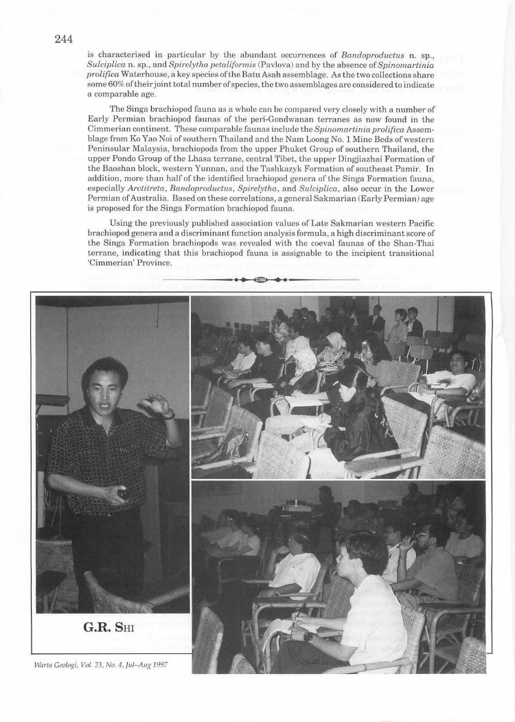
Dr. G.R. Shi of the School of Aquatic Science and Natural Resources Management, Deakin University, Melbourne, Australia, gave the above talk at the Department of Geology, Universiti Kebangsaan Malaysia Bangi, at 10.00 am on 18 July 1997.
Abstrak (Abstract) Permian marine sequences and invertebrate faunas are widely distributed in all
mainland terranes of SE Asia. A review of the spatial and temporal distributions of all major Permian marine invertebrate groups in this region, reinforced by the results of recent Permian stage-by-stage statistical analyses of western Pacific brachiopods, reveals that three biotic provinces were present in SE Asia during the Permian. The Cathaysian Province occupied the Simao, Indo-China and East Malaya blocks throughout the Permian. The Sibumasu Province ofthe Shan-Thai terrane (s.s.), Tengchong and Baoshan blocks developed in Late Sakmarian and continued to exist until, probably, the end of Midian when the same blocks joined the Cathaysian Province. Throughout this period, the Sibumasu Province carried a transitional fauna, which showed a progressively stronger affinity to the Cathaysian Province in the north and increasingly weaker affinity to the Gondwanan provinces (Westralian and Austrazean) in the south. From Asselian to Early Sakmarian, the Shan-Thai terrane, Tengchong and Baoshan blocks belonged to the short-lived Indoralian Province, which then also included Australia, India, the Himalayan and Lhasa terranes.
The marked change of marine provinciality of the Shan-Thai terrane (s.s.), Tengchong and Baoshan blocks cannot be explained by the tectonic vicariance (rift-drift) model alone, nor can it be accounted for solely by migration of climatic zones. An interplay of both of these factors during the Permian is considered to be the most likely cause responsible for this marked change of marine provinciality ofthese blocks.
Early Permian brachiopods from the Singa Formation of Langkawi Island, northwestern Peninsular Malaysia: biostratigraphical and biogeographical implications G.R. SRI
Laporan (Report)
Dr. G.R. Shi presented this second talk at 5.30 pm at the Department of Geology, University of Malaya on 18 July 1997. The natural status from a joint paper with Dr. Mohd. Shafeea Leman (Universiti Kebangsaan Malaysia) and Prof. B.K. Tan (University of Malaya).
Abstrak (Abstract)
This study is based on two brachiopod collections from the upper part of the Singa Formation on the main Langkawi Island off northwestern Peninsular Malaysia. A taxonomic examination of the first collection from Batu Asah has revealed the following brachiopod species: Kasetia cf kaseti Waterhouse, Bandoproductus n. sp., Stenoscisma sp., Rhynchopora culta Waterhouse, Sulciplica sp., Spirelytha petaliformis (Pavlova), Spinomartinia prolifica Waterhouse, ?Martiniopsis sp., Arionthia sapa Waterhouse, and ?Elasmata sp. Ofthese species Spinomartinia prolifica is most predominant, accounting for over 50% of all specimens collected.
The second collection, from the Kilim area some 7 kms northeast of the Batu Asah outcrop, bears close similarity to the Batu Asah assemblage in overall species composition but
Warta GeoJogi, Vol. 23, No.4, Jul-Aug 1997
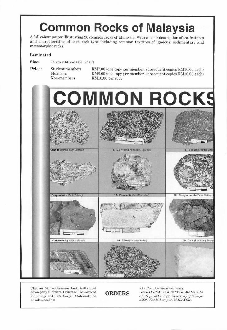
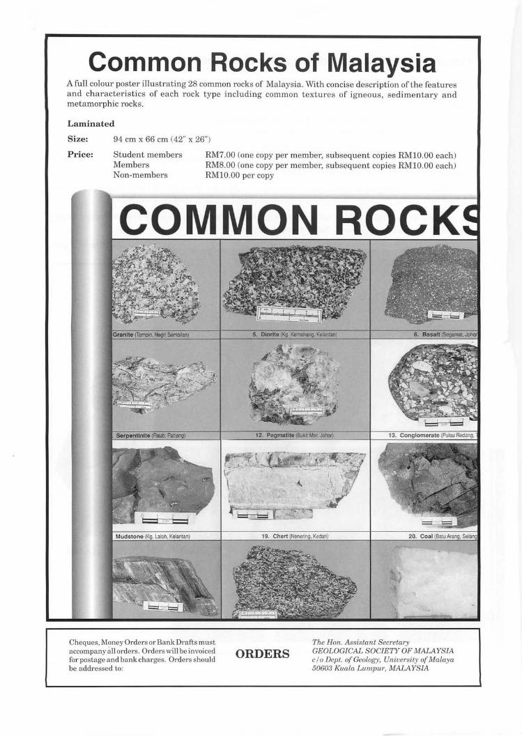
Common Rocks of Malaysia A full colour poster illustrating 28 common rocks of Malaysia. With concise description of the features and characteristics of each rock type including common textures of igneous, sedimentary and metamorphic rocks.
Laminated
Size: 94 cm x 66 cm (42" x 26")
Price: Student members Members Non-members
RM7.00 (one copy per member, subsequent copies RMIO.OO each) RM8.00 (one copy per member, subsequent copies RMIO.OO each) RMIO.OO per copy
COMMON ROCK
Cheques, Money Orders or Bank Drafts must accompany all orders. Orders will be invoiced for postage and bank charges. Orders should be addressed to:
ORDERS The Han. Assistant Secretary GEOLOGICAL SOCIETY OF MALAYSIA c / o Dept. of Geology, University of Malaya 50603 Kuala Lumpur, MALAYSIA
243
Terrane rafting enhanced by contemporaneous climatic amelioration as a mechanism of biogeographical vicariance: Permian marine biogeography of SE Asia. G.R. SHI
Laporan (Report)
Dr. G.H. Shi of the School of Aquatic Science and Natural Resources Management, Deakin University, Melbourne, Australia, gave the above talk at the Department of Geology, Universiti Kebangsaan Malaysia Bangi, at 10.00 am on 18 July 1997.
Abstrak (Abstract) Permian marine sequences and invertebrate faunas are widely distributed in all
mainland terranes of SE Asia. A review of the spatial and temporal distributions of all major Permian marine invertebrate groups in this region, reinforced by the results of recent Permian stage-by-stage statistical analyses of western Pacific brachiopods, reveals that three biotic provinces were present in SE Asia during the Permian. The Cathaysian Province occupied the Simao, Indo-China and East Malaya blocks throughout the Permian. The Sibumasu Province of the Shan-Thai terrane (s.s.), Tengchong and Baoshan blocks developed in Late Sakmarian and continued to exist until, probably, the end of Midi an when the same blocks joined the Cathaysian Province. Throughout this period, the Sibumasu Province carried a transitional fauna, which showed a progressively stronger affinity to the Cathaysian Province in the north and increasingly weaker affinity to the Gondwanan provinces (Westralian and Austrazean) in the south. From Asselian to Early Sakmarian, the Shan-Thai terrane, Tengchong and Baoshan blocks belonged to the short-lived Indoralian Province, which then also included Australia, India, the Himalayan and Lhasa terranes.
The marked change of marine provinciality of the Shan-Thai terrane (s.s.), Tengchong and Baoshan blocks cannot be explained by the tectonic vicariance (rift-drift) model alone, nor can it be accounted for solely by migration of climatic zones. An interplay of both of these factors during the Permian is considered to be the most likely cause responsible for this marked change of marine provinciality of these blocks.
Early Permian brachiopods from the Singa Formation of Langkawi Island, northwestern Peninsular Malaysia: biostratigraphical and biogeographical implications G.R. SHI
Laporan (Report)
Dr. G.R. Shi presented this second talk at 5.30 pm at the Department of Geology, University of Malaya on 18 July 1997. The natural status from a joint paper with Dr. Mohd. Shafeea Leman (Universiti Kebangsaan Malaysia) and Prof. B.K. Tan (University of Malaya).
Abstrak (Abstract) This study is based on two brachiopod collections from the upper part of the Singa
Formation on the main Langkawi Island off northwestern Peninsular Malaysia. A taxonomic examination of the first collection from Batu Asah has revealed the following brachiopod species: Kasetia cf. kaseti Waterhouse, Bandoproductus n. sp., Stenoscisma sp., Rhynchopora culta Waterhouse, Sulci plica sp., Spirelytha petaliformis (Pavlova), Spinomartinia prolifica Waterhouse, ?Martiniopsis sp.,Arionthia sapa Waterhouse, and ?Elasmata sp. Of these species Spinomartinia prolifica is most predominant, accounting for over 50% of all specimens collected.
The second collection, from the Kilim area some 7 kms northeast of the Batu Asah outcrop, bears close similarity to the BatuAsah assemblage in overall species composition but
Warta Geologi, Vol. 23, No.4, lui-Aug 1997
244 is characterised in particular by the abundant occurrences of Bandoproductus n. sp., Sulciplica n. sp., and Spirely tha petaliformis (Pavlova) and by the absence of Spinomartinia prolifica Waterhouse, a key species ofthe Batu Asah assemblage. As the two collections share some 60% oftheirjoint total number of species, the two assemblages are considered to indicate a comparable age.
The Singa brachiopod fauna as a whole can be compared very closely with a number of Early Permian brachiopod faunas of the peri-Gondwanan terranes as now found in the Cimmerian continent. These comparable faunas include the Spinomartinia prolifica Assemblage from Ko Yao N oi of southern Thailand and the N am Loong No.1 Mine Beds of western Peninsular Malaysia, brachiopods from the upper Phuket Group of southern Thailand, the upper Pondo Group of the Lhasa terrane, central Tibet, the upper Dingjiazhai Formation of the Baoshan block, western Yunnan, and the Tashkazyk Formation of southeast Pamir. In addition, more than half of the identified brachiopod genera of the Singa Formation fauna , especially Arctitreta, Bandoproductus, Spirelytha , and Sulciplica, also occur in the Lower Permian of Australia. Based on these correlations, a general Sakmarian (Early Permian) age is proposed for the Singa Formation brachiopod fauna .
U sing the previously published association values of Late Sakmarian western Pacific brachiopod genera and a discriminant function analysis formula, a high discriminant score of the Singa Formation brachiopods was revealed with the coeval faunas of the Shan-Thai terrane, indicating that this brachiopod fauna is assignable to the incipient transitional 'Cimmerian' Province.
--------------_.H.~.~~~.~.~.---------------
G.R. SRI
War/a Geologi, Vo l . 23, No.4, jlll-A llg 1997
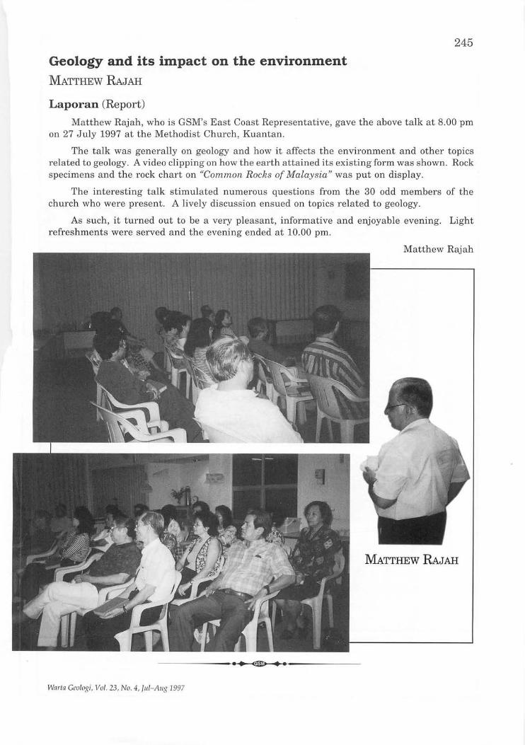
Geology and its impact on the environment MATTHEW RAJAH
Laporan (Report)
245
Matthew Rajah, who is GSM's East Coast Representative, gave the above talk at 8.00 pm on 27 July 1997 at the Methodist Church, Kuantan.
The talk was generally on geology and how it affects the environment and other topics r elated to geology. A video clipping on how the earth attained its existing form was shown. Rock specimens and the rock chart on "Common Rocks of Malaysia" was put on display.
The interesting talk stimulated numerous questions from the 30 odd members of the church who were present. A lively discussion ensued on topics related to geology.
As such, it turned out to be a very pleasant, informative and enjoyable evening. Light refreshments were served and the evening ended at 10.00 pm.
Matthew Rajah
MATrHEW RAJAH
-------------~~.H.~.------------
Wnrtn Geologi, Vol. 23, No . 4, JIll- A ug 1997
Common Rocks of Malaysia A full colour poster illustrating 28 common rocks of Malaysia. With concise description of the features and characteristics of each rock type including common textures of igneous, sedimentary a nd metamorphic rocks.
Laminated
Size: 94 cm x 66 cm (42" x 26")
Price: Student members Members Non-members
RM7.00 (one copy per member, subsequent copies RMIO.OO each) RM8.00 (one copy per member, subsequent copies RMIO.OO each) RMIO.OO per copy
COMMON ROCK
Cheques, Money Orders or Bank Drafts must accompany all orders. Orders will be invoiced for postage a nd bank charges. Orders should be addressed to:
ORDERS The Hon. Assistant Secretary GEOLOGICAL SOCIETY OF MALAYSIA c / o Dept. of Geology, University of Malaya 50603 Kuala Lumpur, MALAYSIA
247
KEAHLIAN (Membership)
The following applications for membership were approved:
Full Members
1. Ahmad Fairus Ahmad Zamri Menara ESSO, Off Jalan Kia Peng, 50450 Kuala Lumpur.
2. Honza Eiichi Jabatan Penyiasatan Kajibumi Malaysia, Ipoh.
3. William Craig Ade JASRA-FCE JV, Unit 309A, Wisma Jaya Bldg., Jalan Pemancha, Negara Brunei Darussalam.
Student Members
1. Mo Kwai Leong Jabatan Geologi, Universiti Kebangsaan Malaysia, Bangi.
2. Faizah Bt. Musa J abatan Geologi, U niversiti Malaya, 50603 Kuala Lumpur.
3. Muhammad Razi Abu Bakar Jabatan Geologi, Universiti Malaya, 50603 Kuala Lumpur.
4. Nur Sharliza Mohd Rapi'ain J abatan Geologi, Universiti Malaya, 50603 Kuala Lumpur.
Institutional Members
1. Australian Mineral Foundation Inc. 63 , Conyngham St., Glenside , South Australia 5065.
4. Guang Rong Shi 662 Blackburn Rd. , Deakin University, Rusden Campus, Clayton, Victoria, Australia.
5. Yong Kock Hui P .O. Box 21532, 88773 Luyang, Kota Kinabalu.
5. Nurmazlin Mohamed Noor J abatan Geologi, Universiti Malaya, 50603 Kuala Lumpur.
6. Rabeatul Adawiyah Zainal Abidin J abatan Geologi, Universiti Malaya, 50603 Kuala Lumpur.
7. Lee Lai Yeen Jabatan Sains Alam Sekitar, Universiti Kebangsaan Malaysia, Bangi.
----------__ H.~.~~~.~.~-----------
Wnrtn Geologi, Vol . 23, No.4, lui-Aug 1997
248
The following members have informed the Society of their new addresses:
1. James K. Blake Blk 140 Bedok North St 2, #14-200 Singapore 460140.
2. Paul Ponar Sinjeng Lot 114 'Sri Kijang', J alan Maxwell, 93000 Kuching, Sarawak
3. Chu Yun Shing 3A-10-8 Jln. 3A/155, Bukit OUG Condominium, Mukim Petaling, 57000 Kuala Lumpur.
4. Honza, Eiichi Department of Earth Sciences, Kumamoto University, 2-39-1 Kurokami, Kumamoto 860, Japan.
----------__ .~ • ._~~.H.~-----------, -,----- ,,';-' ,,;-- -; "--:-,: ---, -:
PERTAMBAHANBAHARUPERPUSTAKAAN (New Library Additions)
,:';',:£ _ _ ,,_-__ L - ":' __ ,- _ _l: _' __ ,',:
The Society has received the following publications:
1. Bulletin ofthe Geological Survey of Japan, vol. 47, no. 12, 1996 & vol. 48, nos. 1-4, 1997.
2. Journal of Geosciences, Osaka City University, vol. 40, 1997.
3. Monthly statistics on Mining Industry Malaysia. March 1997.
4. AAPG Bulletin vol. 81, no. 5, 6, 7, 8,1997.
5. Journal of the Natural History Museum & Institute, Chiba, vol. 4, no. 2, 1997.
6. Natural History Research, vol. 4, no. 2, 1997.
7. Natural History Research, Special Issue, no. 2, 1996.
8. Abstracts of the Geological Congress of Turkey, 1997.
9. Acta Micropalaeontologica Sinica, vol. 13, nos. 2 & 3, 1996.
10. Acta Palaeontologica Sinica, vol. 35, no. 2-4,1996.
11. Palaeontological Abstracts, vol. 11, nos. 2-
3,1996.
12. Bulletin of the American Museum of Natural History, no. 232,1997.
13. Monthly statistics on mining industry, Malaysia, April, 1997.
14. National Science Museum, Bulletin, vol. 23, nos. 1 & 2, 1997.
15. Journal of Shijiazhuang, University of Economics, vol. 20, nos. 1 & 2, 1997.
16. Journal of Hebei College of Geology, vol. 19, no. 6, 1996.
17. Acta Geoscientic Sinica, vol. 18, nos. 1 & 2, 1997.
18. AAPG Explorer, Aug, Sept 1997.
19. American Museum Novitates, nos. 3197, 1997.
20. Tin International, vol. 70, no. 314, 1997.
21. U.S.G.S. Bulletin 1997: nos. 2151, 2146, 1989-1,2153. 1996: 2123.
22. U.S.G.S. Circular: 1997: nos. 1131.
----------__ .~ • ._~~.H.~.-----------Warta Geologi, Vol. 23, No.4, lui-Aug 1997
249
Another step forward for beHer environment State Executive Councillors and Ministers
responsible for the environment today agreed that Macro-EIA be introduced for major land reclamation projects.
They also agreed that the EIA be implemented administratively for all hillslope development projects.
The agreements were made at the 14th meeting between Science, Technology and Environment Minister Datuk Law Hieng Ding and the relevant councillors and Ministers at the ministry.
At a Press conference later, Law described both decisions as an important milestone and a step forward for environmental conservation.
He said the meeting had agreed on the introduction of the Macro-EIA (Environmental Impact Assessment) because of the serious impact ofmajor land reclamation projects on the environment.
The impact included beach erosion, degradation of sea water quality due to excavation works and the socio-economic impact on communities living by the sea.
A macro-EIA basically requires the whole coastal stretch of a State to be studied before land reclamation work on a particular spot could proceed.
This is to determine the impact of the project on the outlying coastal line. Prior to this, EIA reports were only done on a fragmented basis at the spots identified for reclamation work.
Law said that based on the experience of several States, such a practice was not suitable as it could lead to degradation of areas adjoining the reclaimed area.
He said the issue was raised at the meeting by Malacca and Sabah which are currently carrying out reclamation projects along their coastlines.
Warta Geologi, Vol. 23, No.4, Jul-Aug 1997
Asked if the agreement would be made a requirement, Law said this was up to the State Governments.
He said one of the advantages of having a macro-EIA study done in advance was that it would avoid any delays in projects along the coastline once the EIA was approved.
As for the agreement for EIA to be implemented administratively for developments onhillslopes brought up by Selangor and Pahang, he said this was in the interest of environmental conservation and management.
Administrative implementation of EIA requires active participation oflocal authorities in monitoring development projects on hillslopes, abandoned mining land, solid waste dump sites and shore lines.
Law said following the Highland Towers condominium tragedy in December 1993, these areas were identified by the Cabinet as requiring EIA before the project can be approved.
"However, due to legalities these areas cannot be included in the EIA regulation as stipulated under the Environmental Quality (Prescribed Activities) (Environmental Impact Assessment) Order 1987."
"This is the reason why the Cabinet wants the EIA to be done administratively. "
"However, we realise that there are weaknesses among local Governments, including lack of commitment, but the meeting today believes that this can be resolved," he said.
Apart from the four areas, land plots below 50 hectares also do not require EIA. Certain developers are known to escape the EIA requirement although carrying out projects in areas in access of 50 ha by fragmenting the site into smaller plots.
NST, 4.7.1997
250
Petronas bids to enhance role in petrochemical sector Petronas is leading the nation's aim to
become a major player in the regional petrochemical industry, using its vast natural gas reserves for this purpose.
Given that it has proven reserves of over 4.8 trillion standard cubic feet - the 11th largest in the world _. Petronas has undertaken a number of ventures to exploit this resource.
It has a number of ventures for the production of various petrochemical products, including ethylene, polyethylene, propylene, polypropylene, methanol and styrene monomer.
All these products are mainly distilled from natural gas, which is supplied from its offshore platforms off the coast ofTerengganu, which can tap existing reserves for at least 30 years more.
Further, Petronas and other Asean firms have since September 1985 been involved in the Asean Bintulu fertiliser production. And Petronas itself since 1993 has been producing methyl tertiary butyl ether - which is used as
Universities told to boost R&D Local universities should give greater
emphasis to research and development (R & D) and exploit its potential as a prime revenue earner, Education Minister Datuk Seri Najib Tun Razak said.
An "R & D culture" needed to be fostered at universities to develop the country's commitment to research as underlined in the Seventh Malaysia Plan, he said.
He was speaking to reporters after presenting a Letter ofInvitation to the Malaysia University of Science and Technology (MUST) which had been given the go-ahead to become the country's fourth private university.
A member of the MUST Ehsan foundation's Board of Trustees, Datuk Effendi Norwawi, received it on behalf of MUST.
"Local universities should make full use of the relaxed criteria for grants issued under the Integrated Research Priority Areas (lRPA) scheme, whereby expenditure will be based on both fixed and variable costs of the research undertaken," he said.
The change would result in more money for
a substitute for lead in petrol. However, the biggest advantage that
Petronas has with its gas reserves is the capability to be plugged into the proposed Asean gas grid, which is aimed at alleviating the booming energy needs of the region's fast-growing economies.
Within Malaysia itself, Petronas is well advanced in building its network of transmission pipelines.
On the peninsula, the Peninsular Gas Utilisation 1 (PGU1), PGU2 and PGU3 measuring a total of 1,065 kilometres are expected to be completed by year's end.
And to supplement this network, Petronas is constructing another two pipe-lines. The first with a loop of 510 km linking Kertih, Kuantan and Port Klang will be completed by the year 2000.
The second, measuring 710 km, will link Kertih, Penang and Pauh in Perlis.
NST,7.7.1997
the universities to undertake research, said N ajib, who urged them to take full advantage of IRP A's increased allocation ofRMl billion under the 7MP.
"MUST as well as other universities should benefit from this change in criteria and realise the potential ofR & D as an important source of income."
"Universities have to become more competitive and realise that research activities need not be subsidised, which is the situation now but can be a money earner," added Najib.
N ajib cited the Massachusetts Institute of Technology (MIT) which generated one third of its RM2.75 billion revenue from R&D.
The Education Ministry's invitation paves the way for a world-class technology-based institute to be set up in collaboration with the MIT.
MUST, to be located at a 100-acre site at Ulu Bernam, Selangor, has its first intake of postgraduate students slated for September 1998.
Star, 8.7.1997
Warta Geologi, Vol. 23, No.4, Jul-Aug 1997
251
EIA a must for all sensitive area projects in Pahang The Pahang Government has made it
compulsory for developers of all projects in sensitive areas to carry out the environmental impact assessment study.
Menteri Besar Tan Sri Mohd Khalil Yaakob said today even proposed projects on a 2.5-hectare area would require an EIA.
Under the existing law, only projects on 50-ha areas or above are required to have EIA.
He said sensitive areas included highlands, islands, lakes and rivers.
"This directive comes into force with immediate effect," he said after launching the State-level Environment Day at BeIjaya Tioman Beach Resort.
Others present included Deputy Menteri Besar, Datuk Hasan Arifin, State Housing and Environment Committee chairman, Datuk Bahari Yahya, State Executive Councillors and Department of Environment direct-general Tan MengLeng.
Khalil said Pulau Tioman would be the first of the sensitive areas where the new requirement would be enforced.
"The ecology system of the resort island is very fragile and indiscriminate development can result in environmental disaster."
He said proponents of all new projects on highlands, lakes and rivers must also carry out theEIA.
"Highlands in Pahang serve as water catchment areas not only for the State but the
whole peninsula. " "Development has to be very selective.
Therefore, the EIA for all projects is vital," he said.
In an immediate response, Tan said he fully supported what the Pahang Government was doing.
In fact, the meeting of State Executive Councillors in charge of Environment in Kuala Lumpur last week had agreed that the State Government could enforce the EIA requirement for all projects in sensitives area, regardless of their size.
Tan said Pahang was the first State to announce the EIArequirement for all projects in sensitive areas.
On Monday, Selangor State Science, Technology and Environment Committee chairman Ch'ng Toh Eng said all development projects which involved environmentally sensitive areas in Selangor must be referred to the Department of Environment before approval is given.
Ch'ng said this was decided by the Executive Councillors at a meeting on March 25.
He said the Selangor Government had also recently decided to make the EIA requirement for development activities an administrative procedure.
Local authorities would, therefore, be able to implement the EIA regulations currently enforced by the DOE.
NST,9.7.1997
Water quality declining in several rivers Water quality in several river basins in the
State showed a decline last year compared to 1995, State Housing and Environment committee chairman Datuk Bahari Yahya said today.
Eroding water quality was recorded in Sungai Anak Endau, Sungai Ponti an, Sungai Rompin, Sungai Beber-Mercung, Sungai Kuantan, and Sungai Balok-Cherating.
"The first five are still in the clean category. However, Sungai Balok-Cherating has been categorised as sightly polluted," he said at the State Environment Day celebration at the BeIjaya Tioman Beach Resort.
Warta Geologi, Vol. 23, No.4, Jul-Aug 1997
He said water samples collected at 17 monitoring stations located at estuaries and sea showed that oil and grease content exceeded interim standards for recreational purposes.
"Similarly, the suspected solid content in the water is also increasing, " he said.
Five of the monitoring stations are located in Tioman.
"The trend shows the environmental quality has begun to be affected," he said, adding that effective and proper control measures were required.
NST,9.7.1997
252
Only a few applications for R&D grant scheme Response from industries and research
institutions to the Government's RMI00 million Industry Research and Development Grant Scheme has been lacklustre, according to Science, Technology and Environment Minister Datuk Law Hieng Deng.
The IGS secretariat has so far received only a few applications for the scheme aimed at boosting technology development by Malaysian companies.
Under the scheme, launched in March this year, the Government offers grants of up to 70 per cent of the project cost for research and development, to wholly-owned Malaysian companies and Malaysian majority-held joint venture companies.
The scheme is specifically aimed at encouraging companies to link up via joint ventures and technical partnerships with Malaysian universities or research institutes for R&D purposes.
The companies have also been invited to establish strategic global and regional linkages in R&D to enhance indigenous technology development to upgrade their industrialisation process.
Law was speaking to reporters after inaugurating the BASF Textile and Leather Centre Asia Sdn. Bhd. in Pasir Gudang, Johor, on Tuesday.
"One of the reasons for this slow response towards the IGS, is probably because industries or research institutions are still unaware of this scheme."
"I hope more publicity will be generated on the scheme to make them more aware as the
response received by the IGS Secretariat has not been up to expectations."
''Another reason could be industries or research institutions are still busy preparing research proposals for the scheme. "
"I urge the relevant sectors to take full advantage of the IGS scheme to conduct research in technology areas critical to our industrialisation process. "
"On our side, the IGS Secretariat is currently busy promoting this scheme throughout the country," Law added.
He said the scheme was launched by the Government as an additional facility to encourage participation by the private sector, especially the industrial sector, and divert some of its profits to R&D.
"This is in addition to the budgetary allocation allowing companies to deduct RM2 for every RM1 they spend after tax deduction for R&D. It goes to show the emphasis placed by the Government on R&D."
"Companies must realise the importance of R&D in sustaining their growth and to enhance their competitiveness in the world market."
Law said the IGS could be used by the companies to cover R&D staffs salary and travel, rental and other expenses.
He added that at present the Government was offering such aid only to Malaysian-owned companies and joint venture companies with Malaysian majority stake.
He said the Government was open to providing assistance to multi-national corporations which set up R&D facilities.
NST,1O.7.1997
Maju unit joins consortium building KL-KLIA highway Maju Holdings Sdn. Bhd.'s subsidiary Bright
Focu,s Sdn. Bhd. is taking up a 20 per cent stake in the consortium set up to develop the RM1.8 billion-RM2 billion dedicated highway project.
Maju and Bright Focus chairman Datuk Abu Sahid Mohamed told Star Business yesterday that the concession agreement was likely to be signed anytime after July 18 so that works on the project could commence. He anticipated the completion date of 1999 could be
met. Dedicated highway means there would be
one exit and entrance at both ends. The highway will begin from a proposed inter-change at Kampung Pandan in the north, and extend southwards to Putrajaya and finally end at KL International Airport.
The government had issued a letter of intent for the privatisation of the 44.7 km Kuala Lumpur-Putrajaya-KLIA Highway in May last
Warta Geologi, Vol. 23, No.4, lui-Aug 1997
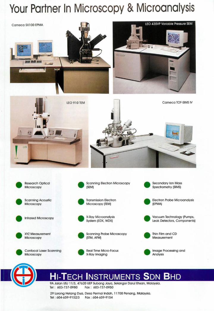
Your Partner In Microscopy & Microanalysis Cameca SX1 00 EPMA
LEO 910 TEM Cameca TOF-SIMS IV
( iii
e Research Optical Microscopy
e Scanning Electron Microscopy (SEM)
e Secondary Ion Mass Spectrometry (SIMS)
e Scanning Acoustic Microscopy
e Transmission Electron Microscopy (TEM)
e Electron Probe Microanalysis (EPMA)
e Infrared Microscopy e X-Ray Microanalysis System (EDX, WDX)
e Vacuum Technology (Pumps, Leak Detectors, Components)
e )0(Z Measurement Microscopy
e Scanning Probe Microscopy (STM, AFM)
e Thin Film and CD Measurement
e Confocal Laser Scanning Microscopy
e Real Time Micro-Focus X-Ray Imaging
e Image Processing and Analysis
.~ WI, HI-TECH INSTRUMENTS SDN BHD 9A Jalan USJ 11/3, 47620 UEP Subang Jaya, Selangor Darul Ehsan, Malaysia. Tel : 603-737-0980 Fax : 603-737-0950
29 Lorong Helang Dua, Desa Permai Indah, 11700 Penang, Malaysia. Tel : 604-659-9152/3 Fax : 604-659-9154
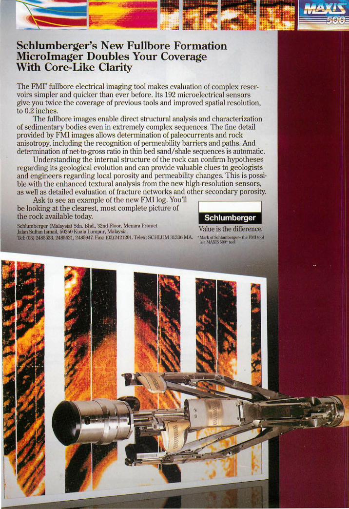
Schlumberger's New Fullbore Formation Microlmager Doubles Your Coverage With Core-Like Clarity
The FMI* fullbore electrical imaging tool makes evaluation of complex reservoirs simpler and quicker than ever before. Its 192 micro electrical sensors give you twice the coverage of previous tools and improved spatial resolution, to 0.2 inches.
The fullbore images enable direct structural analysis and characterization of seclimentary boclies even in extremely complex sequences. The fine detail provided by FMI images allows determination of paleocurrents and rock anisotropy, inclucling the recognition of permeability barriers and paths. And determination of net-to-gross ratio in thin bed sandi shale sequences is automatic.
Understanding the internal structure of the rock can confirm hypotheses regarding its geological evolution and can provide valuable clues to geologists and engineers regarding local porosity and permeability changes. This is possible with the enhanced textural analysis from the new high-resolution sensors, as well as detailed evaluation of fracture networks and other secondary porosity.
Ask to see an example of the new FMI log. You'll be looking at the clearest, most complete picture of the rock available today. Schlumberger (Malaysia) Sdn. Bhd., 32nd Floor. Menara Pro met Jalan Sultan Ismail, 50250 Kuala Lumpur, Malaysia.
~Jmii"j,l§I'M ~ Value is the difference.
Tel: (03) 2485533. 2485621, 2485947. Fax: (03)2421291. Tele.,,: SCHLUM 31336 MA. • Mark ofS<-hlumbergcr-lhe FMllool I~ " MAXIS 500+ 1001
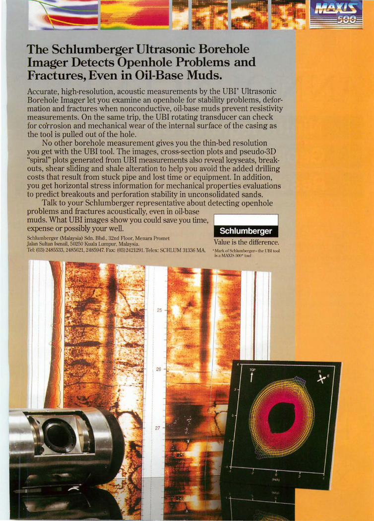
The Schlumberger Ultrasonic Borehole Imager DetectsOpenhole Problems and Fractures, Even in Oil-Base Muds. Accurate, high-resolution, acoustic measurements by the UBI· Ultrasonic Borehole Imager let you examine an openhole for stability problems, deformation and fractures when nonconductive, oil-base muds prevent resistivity measurements. On the same trip, the UBI rotating transducer can check for co'rrosion and mechanical wear of the internal surface of the casing as the tool is pulled out of the hole.
No other borehole measurement gives you the thin-bed resolution you get with the UBI tool. The images, cross-section plot and p eudo-3D "spiral" plots generated from UBI measurements also reveal keyseats, breakouts, shear sliding and shale alteration to help you avoid the added drilling costs that result from stuck pipe and lost time or equipment. In addition, you get horizontal stress information for mechanical properties evaluations to predict breakouts and perforation stability in unconsolidated sands.
Talk to your Schlumberger representative about detecting openhole problems and fractures acoustically, even in oil-base muds. What UBI images show you could save you time, expense or possibly your well. Schlumberger (Malaysia) Sdn. Bht! .. 32ml Floor, M nara PrQmel Jalan Suhan Ismail. 50250 Kuala Lumpur. Malaysia. Tel: (03) 248553:~, 2485621. 2485947. Fax: (03)242129I.TelC'x: SCHLUM 31:3:36 MA. • Mnr'k ur Schlul1Ih" "j("r-I lw 1)13110,,1
is a MAXI 5(XI' 1001
ANNOUNCEMENT Ninth Regional Congress on Geology, Mineral and Energy Resources of Southeast Asia
O1pur, Malaysia. 17-19 August 1998
The Geological .n~"u<L-v· is organising the GEOSEA '98 in Kuala umpur from 17 to 19 August 1998. Congress is held triennially in Southeast Asia and it offers an excellent to e~change scientific and technical information and advancement in geology, mineral and "'n.~1"i'Y1i r.. .r"·C'Al among geoscientists from within and outside the region. The GEOSEA Congress is a geosd entific event in the region and has been well attended by the geoscientific commUnIty
The technical pf()gr;a.m related aspects Malaysia, and technical DV-"'~'~'
the-art products aU!~tlStI~mis.
Other related activl fieldtrips. Social events __ ~~ ..... ~'"
Make a note in your diary "'~~''''~I''''''~
For further information, please contact:
GEOLOGICAL SOClETYOF
MALAYSIA
The Organising Secretary, GEOSEA '98 Geological Society of Malaysia c/o Department of Geology, University of Malaya, 50603 Kuala Lumpur Malaysia Tel: +(603) 7577036 Fax: +(603) 756 3900 Email: [email protected]
, ....,...-""' ..... '""""'..".u'-',,'-' and geological
year to Konsortium Lapangan TeIjaya Bhd. (KLTB).
The consortium members have been locked in negotiations with the Economic Planning Unit of the Prime Minister's Department on several matters including toll rates. However, the concession agreement has yet to be signed.
Works Minister Datuk Seri Samy Vellu had earlier said that the Cabinet had agreed to a change in the consortium of companies undertaking the highway.
He said the new consortium members of KLTB, set up to undertake the project are Lembaga Tabung Haji (LTH), Ansor Perdana Bhd., Hi Summit Construction Sdn. Bhd. and Bright Focus; leaving Seal Incorporated Bhd. out ofthe KLTB.
LTH and Anson will hold 30 per cent stake each in KLTB, with Hi Summit and Bright 20 per cent each.
It is not known why the Cabinet has decided
I"
257
to replace Seal with Bright. Seal senior officials could not be contacted for comments on the issue as welL
Abu Sahid said that Bright Focus had been offered to take up a 20 per cent stake in KLTB recently. Bright Focus, an investment company, is a Maju wholly-owned subsidiary.
Abu Sahid is also chairman of KL TB and was appointed by the government to KLTB's board two months ago.
He said the initial paid-up capital for KLTB was RM30 million and so far a portion of it has been utilised for preparatory works including aligning works for the project.
''We have yet to decide on the type offunding for the project but we have two theories - float KLTB under the infrastructure guidelines or seek funding from banks."
''We do not foresee any problems obtaining funding for the project," Abu Sahid said.
Star, 11.7.1997
Ensuring minimal damage in 2nd highland link works The State Government will ensure minimal
damage to the environment when construction of the second link to Cameron Highlands from Pos Slim in Perak to Kampung Raja is undertaken.
State Infrastructure and Public Amenities Committee chairman Datuk Ong Ka Chuan said today that several departments and agencies were involved in monitoring the RM282 million project.
Among them are the Perak Water Board,
the Forestry Department, Public Works Department, Department of Environment and the State Economic Planning Unit.
''We will ensure that the road construction will not encroach into the water catchment area and that tree cutting will be minimal," he said.
Ong said the State had several discussions with the contractor, Malaysian-Thailand Development Berhad, to do adjustment to the road alignment so as not to degrade the environment.
NST,11.7.1997
New highway can help spur growth for towns' The RM1.35 billion Kajang-Seremban
highway, which will be completed in the year 2000, will be a catalyst for industrial growth for towns along the 48.5 km stretch, Works Minister Datuk Seri S. Samy Vellu said today.
He said the construction of the highway would spur economic growth and rapid development in the towns of Semenyih, Bangi, Pajam, Nilai and Mantin.
Warta Geologi, Vol. 23, No.4, Jul-Aug 1997
He said the current economic activity of these towns would be converted from agricultural activities to industrial and commercial centres once the highway was completed.
"There will also be vast opportunities for housing development as people will prefer to stay in towns which are well connected to the city, "he said when witnessing the Kajang-Seremban highway concession agreement between his
258
Ministry and Kaseh Lebuhraya Sdn. Bhd., a wholly-owned subsidiary of Antah Holdings Berhad.
Under the terms of the concession, Kaseh Lebuhraya would design, construct, operate and maintain the highway for 33 years.
Work Ministry secretary general Datuk Yahya Yaacob and Malaysian Highway Authority director general Datuk Chua Soon Poh signed on behalf of the Government while Kaseh Lebuhraya was represented by its chairman, Tunku Tan Sri Imran Ibni Tuanku Jaafar, and executive director Lew Weng Ho.
Samy Vellu said the Economic Planning Unit in the Prime Minister's Department, his Ministry and Kaseh Lebuhraya were discussing the tool rates to be levied on motorists using the stretch and added that the charges would be reasonable and fair.
tool rates once every six years. Samy Vellu said the Government had agreed
to grant a RM300 million loan to the company for land acquisition along the stretch and the loan would be repaid after a five-year period.
He said the highway would also ease the traffic flow along the North-South Highway as motorists travelling to towns between Kajang and Seremban could use the new highway.
He said the highway would provide motorists with improved accesibility and reduce travelling time in driving between Kajang and Seremban.
Tunku Imran said rapid development in Kuala Lumpur and its peripheries had resulted in massive traffic congestion in once quiet towns like Kajang, semenyih, Pajam, Mantin and Nilai.
''Anticipating this, we have determined that the Kaseh Lebuhraya will provide the benefits of a much needed alternate access route between
He said under the concession terms, the Kajang and Seremban." highway operator could only review or revise the
NST,10.7.1997
Second expedition to measure peaks' height A second expedition to determine the height
of two of the highest peaks on Mount Kinabalu will be launched within a week.
The second expedition will determine the height of a horn on Victoria Peak, estimated to be 4,098 m during the first expedition last month.
The expedition will also to see if St. John's Peak or King Edward's Peak could be anywhere near the height of the Victoria horn.
State Land and Survey Department director Osman Jamal said the second expedition, to be undertaken by his department and the Survey and National Mapping Department, will take about seven days.
Senior officials of both departments will meet on Thursday to work out the technical
! ~, "
details ofthe expedition before the survey teams head up the mountain.
Osman said that due to the extreme difficulty in getting to the top, surveyors will use the Global Positioning System equipment to determine the height ofthe peaks with the aid of satellites.
Department senior surveyor Robert Cheng said the summit plateau of Victoria's Peak had been measured at 4,088 m but the survey team in the first expedition could not determine the height of a horn which has been estimated to be 10 m in height.
The expedition is also expected to map out the terrain so that a computer model could be done, Cheng said.
Star, 14.7.1997
Higher crude oil prices push up Petronas' profit Higher crude oil prices helped pump up
Petronas' pre-tax profit 44.7 per cent to RM12.39 billion for the year ended March 31,1997 from RM8.56 billion previously.
Turnover also rose 29.8 per cent to RM28.89
billion from RM22.25 billion. Group assets rose 17.4 per cent to RM68.16
billion (1996: RM58.05 billion), while shareholders funds grew to RM27.32 billion (1996: RM23.12 billion).
Warta Geologi, Vol. 23, No.4, Jul-Aug 1997
Extraordinary gain stood at about RM4 million compared to RMl.09 billion previously,· which came mainly from the listing of Petronas Gas Bhd. in 1995, said president and chief executive officer Tan Sri Mohamad Hassan Marican.
Total contributions to the Federal and State Governments, in the form of taxes and royalties, was 30 per cent higher. Dividend payout to the Government maintained at RM3.1 billion.
In announcing the results yesterday, Hassan said Malaysian crude oil prices averaged US$22.29 (RM55.05) per barrel as compared to US$18.86 the previous year.
The higher crude oil price also resulted in better prices for the liquid natural gas.
"The increase in crude oil prices was due to a combination offactors including the severe winter in the northern hemisphere, creating higher demand for energy. The low inventory level of the oil refiners further contributed to increased world crude prices."
He said crude oil prices would likely remain above the US$18 per barrel mark in the current year.
Hassan also said Petronas was not too affected by fluctuation in the currency exchange rates, as it was servicing its debts in US dollars.
In his analysis, Hassan said sales from
liM
259
refined petroleum products chalked up 13.4 per cent higher revenue despite a 7.2 per cent dip in volume sold.
On the global front, Hassan said contributions amounted to 13.84 per cent of group turnover, or RM3.998 billion, adding that this showed Petronas was on track towards achieving a 30 per cent overseas contribution by 2005.
On a sectoral basis, Hassan said RM19.47 billion or 67.4 per cent of the turn-over came from exports of crude oil, refined petroleum products, natural gas, LNG and petrochemicals.
"Natural gas and gas products remained as the largest contributor to group revenue. This year, this sector generated RMI0.098 billion." (1996: RM7.91 billion).
Of this total, RM7.64 billion (1996: RM5.57 billion) arose from export sales, primarily LNG. The remainder was sold in the domestic market, primarily to the power sector.
Petronas produced 179 million barrels (1996: 173.9 million barrels) of crude oil during the year under review. Of this, 149.19 million barrels of crude was exported, generating revenue of RM8.31 billion (1996: RM5.42 billion).
Refined petroleum products generated income ofRM7.23 billion (1996: RM6.37 billion) for the period under review.
NST, 15.7.1997
Artifacts found at Putra-LRT site Past and present collided yesterday when
work on the Putra-LRT construction site behind Central market unearthed over 100 pieces of artifacts dating as far back as the late 1700s.
Museums and Antiquities Department officials, who were contacted by Putra after the discovery at about 5 pm, converged at the site today and found that the cache of artifacts consisted largely of blue and white ceramics and clay pottery fragments.
Of the blue and white pieces, only one small bowl appeared intact. Other objects included wine jars, a small metal teapot, a large metal spoon and a one sen coin with the head of Queen Victoria and the date 189l.
Reporters were also led to a spot where two clay jars, one apparently intact, were embedded in the ground.
Warta Geologi, Vol. 23, No.4, luI-Aug 1997
Preliminary examination led officials to conclude that the pieces dated back to between the late 18th and early 19th centuries. The porcelain bowls, they said, were from the late Ming to early Ching period.
However, the department's director-general Dr. Kamarul Baharin Mohd Nor, who headed the official delegation, said officials would not call for a stop-work order on the construction.
"These are artifacts of the original Kuala Lumpur settlement and they reflect the daily existence of the early Chinese miners."
"But to carry out an archaeological excavation would technically be very difficult. There has already been so much development and everything has been jumbled up," he said, pointing to river embankments and commercial buildings surrounding the site.
260
Although this was the second such discovery reported at the construction site in the last week, this marked the first time officials were able to view and claim the artifacts.
On Saturday, the department announced an investigation into the purported sale of ceramics uncovered by construction workers.
Tipped off by an antique dealer who had been approached to buy an artifact, department officials interviewed several workers and found that some of them had stumbled across the pieces as early as three weeks ago.
Director of the museums and antiquities division Adi Taha, who was also present, appealed to anyone who might be in possession of the artifacts to turn them over to the
department. "The artifacts are historically invaluable,"
he said. "Although documents show that this site near the confluence of the Klang and Gombak rivers is where the original KL settlement was, these findings help to confirm that."
"Under the Antiquities Act of 1976, any such findings would be the sole property of the Federal Government, " he added.
The site, onJ alan Bentengnear Putra-LRT's twin-tunnelling construction project, was originally occupied by a row of thatched-roof shophouses frequented mainly by miners.
Kamarul said Putrahad agreed to co-operate by informing the department of any other finds in future.
NST, 16.7.1997
" I
Joint venture company for fibreglass production formed Malaysia's first fibreglass manufacturing
venture got a kick-start yesterday with the signing of a tripartite agreement between PJS Industries Sdn. Bhd., Japan's Central Glass Co. Ltd., and the Government's investment arm Khazanah Nasional Bhd.
Categorised as a strategic industry due to its wide usage, the fibreglass factory, to be constructed by joint venture company Malaysian Central Fibreglass Sdn. Bhd., will soon satisfy the demand for fibreglass in the country.
When completed, the factory is expected to be the biggest in the Asean region. Turnover for the first year of operation is estimated at RMBO million.
Construction of the plant, to be located on a 4.04 ha site in Cinta Sayang Industrial Estate, Sungai Petani, Kedah, will begin by the end of the year.
Production is scheduled to commence in the middle of 1999 with a capacity of 9,600 tonnes per year.
Of the total 9,600 tonnes to be produced, 5,000 tonnes will be for local consumption while the rest will be exported to the region .. The total demand for the region is estimated at 23,000 tonnes a year.
Involving a total investment of RMllO
million, the plant will produce E-glass fibre, a reinforcement composite material widely used by the high-technology manufacturing sector.
E-glass accounts for 90 per cent of all composite materials used for reinforcement in manufacturing.
Glass fibre is used in the production of disc brakes, car body parts, freighting containers and others.
The raw materials used in its production such as silica, kaolin clay, limestone and colemanite are widely found locally.
The company's paid-up capital is RM22 million.
PJS will hold a 55 per cent stake in the joint venture, Central Glass 25 per cent and the remainder 20 per cent will be taken up by Khazanah N asional.
Apart from the joint venture agreement, a technical agreement was also signed yesterday between Central Glass and Malaysian Central Fibreglass for the transfer of technology and training.
Under the agreement, Central Glass will assist local personnel in the start-up and operations of the plant and provide on-the-job training on plant equipment, operations and administrative procedures.
NST., 19.7.1997
Warta Geologi, Vol. 23, No.4, Jul-Aug 1997

261
Johor raising stake in Aussie gold firm to 32 pc The Johor State Government's investment
arm, PJB Capital Holdings Sdn. Bhd., will be raising its stake in Australian Gold Fields NL to 32 per cent, having received the approval for the proposal from the Australian Foreign Investment Review Board.
In a statement yesterday, Australian Gold Fields managing director Cyril Quek said the
. proposal follows the successful A$55 million (RMI06 million) capital raising exercise recently.
Under the earlier exercise, PJB was entitled to 20 million shares at 85 cents (RM1.64) each and also has the right to acquire a further 11.25 million shares through the conversion of convertible notes.
Other Malaysian firms that have invested in Australian Gold Fields include Permodalan N asional Bhd. and venture capital investor PICA.
Australian Gold Fields, listed on the Australian Stock Exchange, commenced
! "
operations with one project at Bannockburn, approximately 600 kilometres northeast of Perth in the Mount Margaret Goldfield of Western Australia.
Bannockburn has since been expanded and upgraded into a significant regional mine and is on track to produce 100,000 ounces of gold this current financial year.
The company has acquired two major gold deposits from Rio Tinto and Goldfields Limited in Papua New Guinea and combined them into the Morobe Gold Project with a gold resource of . six million ounces.
Australian GoldFields has received an award for the best public floatation by an Australian gold company in the past year.
"InAustralia we have the world's third biggest gold mining industry, much of it is based in WesternAustralian and we recognise that Asia is becoming our biggest consumer," said Quek.
NST,19.7.1997
, f
Work on highway expected to begin by year's end Construction of the East Coast Highway is
expected to start by the end of the year, Works Minister Datuk Seri S. Samy Vellu said today.
He said work would start after negotiations between the Economic Planning Unit and the consortium, led by Malaysian Mining Corporation Berhad, have been concluded.
The RM3.5 billion project, which was supposed to start in the middle of this year, will
be carried out in two phases linking Karak and Kuantan in the first phase and Kuantan to Kuala Terengganu in the second phase.
Samy Vellu said the highway would be another alternative route to Terengganu, which has an abundance of tourist spots including beautiful beaches and lakes.
He said this after chairing Terengganu MIC annual general meeting.
NST,19.7.1997
Realignment of expressway to be ready in nine months Projek Lebuhraya Utara-Selatan Berhad is
undertaking rehabilitation work on the hillslopes at the 308.8 km stretch of the North-South Expressway near Gua Tempurung, to prevent erosion.
A spokesman for PLUS said works were being carried out in two stages.
The first stage involves the rehabilitation of the slope by way of rock buttressing, while the second involves permanent realignment to
Warta Geologi, Vol. 23, No.4, lui-Aug 1997
conform to "required expressway standards". Realignment work is being carried out as
the temporary slip road can only be used at a slow speed.
Work has been going on since June 16 and is expected to be completed in nine months' time.
The work is being carried out by PATI Sdn. Bhd.
On Jan 6 last year, the slope caved in due to erosion, damaging the concrete embankment
262
which collapsed onto the highway killing a lorry attendant, Abdui Hamid Kodin, 33, while driver Hasri Hamid, 37, escaped unhurt.
Following the incident, a temporary 704-metre slip road was constructed to divert traffic from the slopes.
Meanwhile, State Infrastructure and Public Utilities Committee chairman Datuk Ong Ka Chuan said the area had been closely monitored by PLUS since the landslip.
"Soil tests are being conducted to determine
the extent of erosion. Where there is a need, repair works on the slopes will be carried out," he told the New Straits Times.
He added that erosion has occurred on both the collapsed section of the slope and the slope near Gunung Tempurung.
Ong said it had been agreed that a new road, built according to highway specifications, would be constructed parallel to the existing one just after the slip road.
NST, 19.7.1997
Stone quarrying industries output of RM1.26b in 1995 The stone quarrying industries recorded a
gross output value ofRM1.26 billion for 1995, a increase of 21 per cent compared with that in 1993, the Statistics Department said.
The cost of input went up by 22.3 per cent to RM566 million; census value added 20 per cent to RM694 million, total number af persons engaged was up 13.3 per cent to 13,700, salaries and wages paid increased 28.7 per cent to RM206 million while value offixed assets jumped 48 per cent to RM731 million. The number of establishments increased by 11 to 258 in 1995 from 247 in 1993.
According to the department, the decision to release the preliminary estimates of the stone quarrying industries was taken based on the awareness of the needs of the majority of users who require up-to-date data on the stone quarrying sector.
The information was canvassed through the Annual Census of Stone Quarrying Industries in 1996 for the reference year 1995. Commencing reference year 1993, the census is conducted biennially.
The final results of this census will be published in the Annual Censuses of Mining and Quarrying Industries 1996.
On principal statistics by industry, granite quarrying was the major activity in the stone quarrying sector in 1995. Of the total of 258 operating establishments, 163 were in this industry; accounting for 76.1 per cent (RM958.6 million) of the value of gross output and 69.1 per
cent (9,443 persons) of the total number of persons engaged in this sector.
Compared with reference year 1993, the industry registered a growth rate of 19.8 per cent to RM958.6 million in terms ofthe value of gross output; 23.2 per cent to RM437. 7 million in terms of the cost of input.
In terms ofthe census value added it recorded 17.2 per cent to RM520.9 million; 12.8 per cent to 9,443 persons in terms of the total number of persons engaged; 28.2 per cent to RM147.2 million of the salaries and wages paid; and 48.5 per ceni to RM554.6 million of the value offixed assets.
Limestone quarrying ranked second in the stone quarrying sector with 64 operating establishments in 1995.
It contributed 17.9 per cent (RM225.9 million)to the value of gross output and 21. 7 per cent (2,966 persons) to the total number of persons engaged in the limestone quarrying sector.
Compared to the reference year 1993, the industry registered a growth rate of 21.9 per cent to RM225.9 million in terms of the value of gross output; 9.6 per cent to RM92.8 million in terms of the cost of inputs; 32.3 per cent to RM133.1 million of the census value added; 10.5 per cent to 2,966 in terms of the total number of persons engaged; 32 per cent to RM47.1 million in respect of the salaries and wages paid and 39.9 per cent to RM114 million in terms of the value of fixed assets.
Star, 19.7.1997
Warta Geologi, Vol. 23, No.4, Jul-Aug 1997
263
Mamut not halting mining operations Mamut Copper Mine Sdn. Bhd. (MCM), the
operator of the country's largest mining project, plans to continue with its mining operations even after the June 2000 scheduled closure of the Mamut copper mine in Ranau.
Mega first Corp. Bhd. (MFCB) group managing director Datuk. Lim Keng Kay said
MCM, a wholly-owned subsidiary ofMFCB, was in the process of prospecting for metal ores around the vicinity of the present MCM mining site.
"We are planning to continue with out mining operations as far as possible. If we could not find it here, we will go overseas," he said.
Star, 19.7.1997
MP: Ensure local participation in Mamut resort Parti Bersatu Sabah Member of Parliament
for Kinabalu Henrynus Amin today expressed support for the RM2 billion plan to convert the Mamut Copper Mine area into a resort by 2000.
But Henrynus urged MCM Resort to ensure local participation in terms of employment and business opportunities.
He also cautioned against implementing the project without first getting the Environmental Impact Assessment report, which is mandatory.
"The MCM area falls within the water catchment areas of the Liwagu and Mokodou rivers and would affect thousands of people here," he said, adding that there was major concern about a potential pollution problem.
Henrynus said residents, both living in the area and those employed by MCM, should be given preference with regards to employment and business opportunities.
"As the MP, I will monitor the project closely to ensure effective local participation. "
"I would also like to see retraining programmes for the existing staff ofMCM so that they could be absorbed into the new project, " he
said. Henrynus, also the PBS Ranau Division
chief, called for transparency in the approvals of the project to protect the interests of the public.
"The 2,OOO-hectare original mining concession to MCM is easily worth a quarter of a billion ringgit at the market price. There is also a question of whether other proposals had been considered," he said.
He added that the prospect of tourism infrastructure should promote alternative economic activities to give the economy in Ranau a boost after MCM stopped its mining activities.
"My concern is for the welfare of MCM employees and their families and also for residents who are directly or indirectly dependent on MCM for their livelihood."
Chief Minister Datuk Yong Teck Lee had unveiled the conceptual plans for the MCM Resort on July 18.
The resort, to be built over 20 years, is expected to provide about 7,000 jobs once fully operational.
NST,21.7.1997
Tremors felt in the peninsula after quake in Sumatra Tremors shook parts of the peninsula
yesterday following an earthquake in northern Sumatra, sending thousands of office workers and residents scrambling out of high-rise buildings.
The tremors, which began at 3.16 pm, were felt in Petaling Jaya, Shah Alam, Penang and Alor Star.
Warta Geologi, Vol. 23, No.4, luI-Aug 1997
According to a Meteorological Department Seismology Division spokesman, preliminary data traced the earthquake's epicentre to northern Sumatra, at 4 degrees North, 97.5 degrees East.
The quake registered 6.0 on the Richter scale. An earthquake of similar strength hit J abalpur, India, in May, killing 74 people. While
264
the tremors were felt for only a few seconds, the department's instruments picked up vibrations which lasted about six minutes.
Office workers on the fifth floor of Crystal Plaza building in Petaling J aya here had a fright when they felt the building starting to sway.
"Signboards in a workshop shook and chairs moved. Some girls screamed. We were really shaken up, " said an office supervisor who declined to be named.
The tremors also shook the Nestle factory and Wisma MCIS, both in Petaling Jaya, as well as Wisma Hicom in Shah Alam.
An advertising executive who wanted to be identified as only Wong said she was on the sixth floor of Wi sma MCIS when she felt four tremors, at about two to three second intervals.
Terrified, she looked out of the window and saw the scaffolding of the construction project next door beginning to shake.
"The first thing on my mind was Highland Towers (which collapsed in December 1993). It was really scary, » she said, adding that she then rain out of the building.
Workers and other people in Wisma MCIS and Wisma Hicom similarly scurried out when they felt the tremors.
In Penang, office workers and shoppers at the 27 -storey Midlands One-Stop Centre quickly left the building when they felt the tremors. Several shops were closed temporarily.
However, four people continued swimming at the centre's rooftop water theme park, unaware of the commotion.
Star, 21.7.1997
DOE: Study on haze yet to be approved A proposed two-year study by the
Department of Environment to tackle the haze by pinpointing its specific causes has yet to begin despite being mooted almost a year ago.
DOE director-general Tan Meng Leng said the proposal for the study based on the recommendations by Australia's Commonwealth Scientific and Industrial Research Organisation (CSIRO) has not yet been approved.
"The matter is still with the Treasury Department, » he said.
Last September, the DOE had accepted a CSIRO recommendation to use a method called "finger-printing" and DOE deputy directorgeneral Rosnani Ibrahim had said that two new monitoring stations would be set up in the course of the study.
The study, expected to cost RM500,000, would help determine the complex composition of the haze and provide detailed analysis of its chemical compounds to identify the specific cause.
"This is the only way we can really combat it. Presently, we can determine the level of pollutants such as smoke but we need to find out if the smoke is due to the combustion of biomass such as trees and bushes in order to trace it, " Tan said.
On Wednesday, Science, Technology and
Environment Minister Datuk Law Hieng Ding declared the haze as a national disaster, adding that an action plan would be activated if air quality reached hazardous levels.
Tan said the DOE had begun sending daily updates on the air quality index to inform the public on the haze situation.
Meanwhile, the air quality figures released by the DOE showed that Gombak recorded a high figure of 101 and was classified "unsafe".
The status of air quality over here and Petaling Jaya was only slightly better at 94 and 95 respectively, which placed them in the "moderate" category.
Kajang also recorded a high figure of 95. Other areas which also recorded "moderate"
levels were Klang, Seberang Prai, Ipoh, Sungai Petani and Nilai. East coast towns such as Kuantan, Kota Baru and Kemaman were in the "clear" category.
The poor air quality levels also has an impact on the health of those in the affected areas.
According to a medical officer at Kuala Lumpur Hospital, more people sought outpatient treatment for asthmatic and respiratory problems during hazy periods and days when heavy pollution was recorded.
Star, 28.7.1997
Warta Geologi, Vol. 23, No.4, Jul-Aug 1997
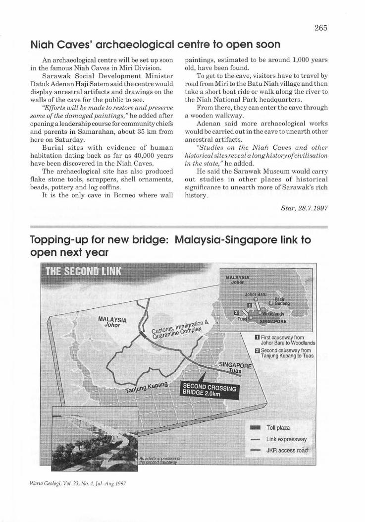
265
Niah Caves' archaeological centre to open soon An archaeological centre will be set up soon
in the famous Niah Caves in Miri Division. Sarawak Social Development Minister
DatukAdenan Haji Satem said the centre would display ancestral artifacts and drawings on the walls of the cave for the public to see.
"Efforts will be made to restore and preserve some of the damaged paintings," he added after opening a leadership course for community chiefs and parents in Samarahan, about 35 km from here on Saturday.
Burial sites with evidence of human habitation dating back as far as 40 ,000 years have been discovered in the Niah Caves.
The archaeological site has also produced flake stone tools, scrappers, shell ornaments, beads, pottery and log coffins.
It is the only cave in Borneo where wall
paintings, estimated to be around 1,000 years old, have been found.
To get to the cave, visitors have to travel by road from Miri to the Batu Niah village and then take a short boat ride or walk along the river to the Niah National Park headquarters.
From there, they can enter the cave through a wooden walkway.
Adenan said more archaeological works would be carried out in the cave to unearth other ancestral artifacts.
"Studies on the Niah Caves and other historical sites reveal a long history of civilisation in the state," he added.
He said the Sarawak Museum would carry out studies in other places of historical significance to unearth more of Sarawak's rich history.
Star, 28.7.1997
Topping-up for new bridge: Malaysia-Singapore link to open next year
Wnrtn Geologi, Vol. 23, No.4 , flll-Allg 1997
266
The topping-up ceremony for the 2 kIn second crossing bridge is scheduled for Thursday when Works Minister Datuk Seri S. Samy Vellu and his Singaporean counterpart Lim H'ng Kiang will connect the link between both countries.
However, the official opening ceremony will take place early next year by the prime ministers of both countries.
The six-lane causeway connecting Singapore from the Tanjung Kupang end will be able to cater to a maximum traffic flow of 200,000 vehicles daily and this is about four times the current traffic flow.
Samy Vellu said the total cost of the second crossing was about RM1.3 billion.
Other facilities included a Customs, Immigration and Quarantine Complex together with an additional 60-entry and exit lanes for Customs and Immigration checks.
"The opening of the second link is expected to be a boost for business for both countries."
"This will mean more business activity along Gelang Patah and the Pasir Gudang industrial zone," Samy Vellu said.
With the second link, the 72-year-old causeway now linking J ohor Baru and Singapore will be demolished and replaced with a suspension bridge to promote shipping and ease water flow along the Johor Straits.
Star, 29.7.1997
Sand from the straits for Kedah project The Langkawi Development Authority
(Lada) has received proposals to extract sand from the sea bed of the Straits of Malacca for Kedah's RM30 billion reclamation project.
Lada deputy general manager Mohd Puat Ali said sand suppliers claimed that it would be cheaper to extract sand from the straits than importing it from Acheh.
He said some suppliers had already "secured" the lease of several high-tech sand transport vessels from Netherlands.
"These vessels, costing almost RM1 00 million a unit, are able to suck sand five kilometres from where they are berthed, » he added.
A similar method was used in several land reclamation projects in Malacca and Singapore.
Puat said Lada had received a list of 16 sand suppliers interested in the project. Their prices range from RM14.50 to RM25 per cubic metre.
Prime Minister Datuk Seri Dr. Mahathir Mohamad, concerned about the spiralling cost of sand, proposed that Lada be made the sole importer.
Lada plans to get its supplies from Pulau Chermin, which is located in Acheh, Sumatra.
Some nine billion cubic metres of "fill material" is needed for the land reclamation project. More than half of this is sand.
Star, 31.7.1997
Reclamation project may well spur landbridge plan After centuries of being a major shipping
route, the Malacca Straits may finally become a minor cargo passageway following a massive economic project off the coast of Kedah.
The land reclamation project will kick off later this year, with the first phases by Samudera Barn Darul Arnan Sdn. Bhd., and will become a key development towards the establishment of a landbridge across the north of the peninsula.
While negotiations with Thailand have yet to progress significantly, the project of the Kedah shore will establish some of the key facilities
that could become the starting point of the landbridge proposal.
It will feature a multimodal cargo centre with a seaport, an adjacent airport on a reclaimed island and rail and road links to the mainland.
And with facilities already available in Penang, this cargo infrastrnctural network is set to drive the economic growth of underdeveloped areas within the Indonesia-MalaysiaThailand Growth Triangle.
Samudera Barn chairman Azizan Abdul Rahman said work on the multi-billion ringgit
Warta Geologi, Vol. 23, No.4; Jul-Aug 1997
project should take offby the end of this year and that the new international airport would be one of the first facilities to be made available by 2002.
"Work on other facilities like the seaport will also run in parallel so that they will all be ready soon after the airport is opened," he said in an interview last Friday at his office in Kuala Lumpur.
But while the overall masterplan has been adopted, the finer details have yet to be worked out.
Samudera Baru has so far only received approval to conduct the reclamation of two islands totalling 4,000 ha - subject to final approvals after the environmental impact reviews.
This work has been contracted out to Hock Seng Lee Bhd., a Sarawak firm listed on the Kuala Lumpur Stock Exchange last June which has extensive experience in land reclamation and dredging works.
However, the rest of the development contracts have yet to be given out.
On these two islands, initial approvals have been given for the development of a seaport, a new international airport, a petrochemical tanking complex and a free trade industrial zone.
c
267
The airport, which was the subject of recent controversy over the plan for it to take over the role of the existing one on Penang island, will have one of the world's longest runways measuring four kilometres.
For the next phase, land will be further reclaimed for a second runway.
Azizan said Malaysia Airports Bhd. was still studying the runway proposal in terms of its directional bearings.
In terms of funding, he said that the estimated RM6 billion reclamation cost would be easily recovered.
"For every 50 hectares of land we reclaim, the land title for that piece is immediately given to us and it can be pledged as security for bank loans. "
"But any loans we take will mainly be for bridging purposes. We intend to sell most of the land for industrial use and the estimated sales value is RM8 billion," Azizan said.
Azizan has the largest stake in Samudera Baru with 36 per cent, with Hock Seng Lee's executive chairman, Dennis Yii Chee Ming, holding the next largest block of 25 per cel).t in his own capacity.
The other two shareholders are architect Teo Ah Khing (24 per cent), who is also the brains behind the conceptual masterplan, and Samudera Baru director Kalimullah Hassan.
NST,11.8.1997
Perlis National Park likely to open next year The proposed 5,165 ha Perlis National Park
will open in the middle of next year. State Forestry Committee chairman Che Ah
Long sand the State Government had received a RM1.5 million Federal allocation to start building the park's infrastructure.
"We'll make available additional facilities as we obtain more grants."
"If work proceeds according to plan, the required infrastructure will be ready in three years," she added.
Che Ah said the State had accepted in principle the proposal on park infrastructure submitted by World Wide Fund for Nature Malaysia.
The State has commissioned WWF to work on a five-year management plan for the park.
She also said the park would be staffed by
Warta Geologi, Vol. 23, No.4, Jul-Aug 1997
the State Forestry Department, which is undergoing a reorganisation exercise expected to be completed by the year 2000.
The park is to comprise the MataAyer Forest Reserve at Wang Kelian, Wang Tangga and the adjoining proposed Wang Mu Forest Reserve on the northern tip of the 36 km-Iong Nakawan Range.
Nakawan straddles the Malaysia-Thai border and is the country's longest known continuous limestone range.
The WWF management plan aims to implement and coordinate the park establishment and management so that its natural resources can be effectively safeguarded.
"It includes recommendations on the longterm objectives for the park; its legislative and administrative framework; management
268
strategies and the development of the park for tourism," said WWF senior scientific officer, Hymeir Kamarudin.
The plan has identified park programmes and activities and for these to be carried out, buildings and other facilities have to be constructed.
"The bulk of infrastructure will be at the park headquarters at Wang Kelian."
"Other buildings and facilities will be at
various locations according to the park's zoning plan,' he said.
Hymeir said more programmes and activities had been identified to be developed and implemented.
"These included land-use management, natural resources management, research and establishment of a database and monitoring centre," he said.
o NST, 11.8.1997
Target Mining expands exploration area Perth-based Target Mining Corporation
Limited has expanded its exploration area with several deals recently to boost its total gold mining operatorship to about 1,500 sq km.
The deals are in line with the company's bid to become the dominant gold exploration firm in Malaysia, it said in a statement, without disclosing further details.
The 1,500 sq km area in Pahang includes the Selinsing gold project, presently the subject of a feasibility study for a 500,000 tonne a year mining operation, and Ulo Sukor in the northern part of Kelantan.
"Exploration drilling during the June quarter has successfully delineated additional mineralisation to the south of the contained Selinsing resource of 325,400 ounces."
''We believe this resource can be increased by 45,000 to 60,000 ounces with additional infill drilling, "said its managing director Peter Kestel.
No oil, gas off Pahang No petroleum or natural gases were found
along the Pahang coast, Deputy Minister in the Prime Minister's Department Datuk Mohamed N azri Aziz said.
Replying to a question from Senator Datuk Mohd Zuki Kamaluddin, he said eight expedition wells were dJlg in the area to see if there was any
He said the company would undertake further upgrading at the Selinsing site since recent drilling at the southern exten/iion of the site yielded 18 m at 2.6 g/t of gold, while encouraging intersections were also encountered at nearby projects.
At Daling, about 20 km northeast of Selinsing, assay results included 29 m at 1.1 g/ t and 3 m at 13.6 g/t. Only 160 metres of the estimated 1,500 m strike length have been tested:
Kestel said at Medang Ridge North, about 1.5 km to the east of Selinsing, many 3 m intersections were made averaging between 0.5 g/t and 1.1 g/t.
On development at Ulo Sukor, Kestel said regional exploration works had started at the site.
''A drilling rig is being mobilised from the Pahang project to further upgraded the 240,000 oz inferred resources. "
NST,11.8.1997
petroleum or natural gases. Meanwhile, Transport Ministry
parliamentary secretary Chor Chee Heung said the Government had no plans to extend the Batu Berendam airport in Malacca as it was large enough to handle the present and future traffic.
He was replying to Kasim Mh Yusop.
NST, 11.8.1997
Warta Geologi, Vol. 23, No. 4, Jul~Aug 1997
269
Penang wants undersea link to new airport Penang has proposed a new bridge or
undersea tunnel and a super highway linking the island with the Northern Region International Airport in Kedah.
It has also suggested that the new airport should straddle the border between the two states to spur greater development in the northern region.
Chief Minister Tan Sri Dr. Koh Tsu Koon said yesterday he was glad the Prime Minister accepted both his proposals which were submitted to him soon after his return from vacation last month.
He said his proposal for the "joint airport" was a long-term solution to Penang's as well as the northern region's development in the context of the Indonesia-Malaysia-Thailand Growth Triangle.
"Part of the new airport will be located in the northern part of the mainland, and linked to George Town by a new super highway and undersea tunnel or bridge," he told a press conference.
Dr. Koh, who expressed his sadness that the
Penang airport might be closed in a few years, said the state would work closely with the Federal Government on the matter.
Yesterday, Datuk Seri Dr. Mahathir Mohamad said the Penang airport would eventually be closed when the new airport in Kuala Muda opens.
The Prime Minister said this was because the Penang airport lacked sufficient land for expansion to cope with the increasing air and passenger traffic.
Dr. Koh said the Penang airport's new cargo complex and extension works on the passenger terminals would go on as planned, just as the Subang airport was being expanded during the planning and construction of the KL International Airport in Sepang.
The new airport and linking infrastructure would only be ready in eight to 10 years, he said.
On the super highway, he said it would be built on reclaimed land with the proposed bridge linking Penang's Jelutong Expressway, Penang Outer Ring Road and the Butterworth Outer Ring Road.
Star, 16.8.1997
Low's Peak is highest in. South-East Asia Mount Kinabalu's Low's Peak is the highest
point in South-East Asia, overshadowing the nearby Victoria Peak by 1.7 m.
An expedition mounted by the National Mapping and Survey Department last month found that the height of Low's Peak was 4,095.2 m.
Institute of Surveyors Malaysia (ISM) Sabah branch chairman Ho Kin Wong said the expedition also determined that the height of Victoria's Peak was 4,093.5 m.
The findings of the department put to rest any doubts about the status of Low's Peak after an earlier expedition on June 25 found that Victoria Peak could be several metres higher.
"The belief of the June 25 expedition organisers is not true," Ho said. The earlier expedition was jointly organised by ISM Sabah and the state Lands and Survey Department.
On Aug 17, Prime Minister Datuk Seri Dr. Mahathir. Mohamad proclaimed the official
Warta Geologi, Vol. 23, No.4, lui-Aug 1997
height of Mount Kinabalu's summit at the Sabah state assembly building and later placed the proclamation certificate in a time capsule.
Dr. Mahathir also placed a RM2 note with his signature in the capsule, while his wife, Datin Seri Dr. Siti Hasmah Mohamad Ali contributed a Piala Perdana porcelain souvenir.
Ho said the time capsule would be placed in the Kinabalu Park headquarters and would be opened on June 25, 2050.
He said the director-general of the National Survey and National Mapping Department had informed the Sabah government that the measurement of Low's Peak was done by the World Geodetic System 84 which was developed by the United States.
"In the past, all heights were measured by systems developed by the British. The June 25 measurement of Low's Peak was done with the British system," he said.
NST,20.8.1997
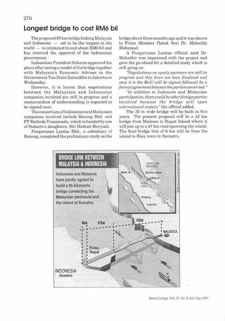
270
Longest bridge to cost RM6 bil The proposed 95 km bridge linking Malaysia
and Indonesia - set to be the longest in the world - is estimated to cost about RM6 bil and has received the approval of the Indonesian government.
Indonesian President Suharto approved the plans after seeing a model of the bridge together with Malaysia's Economic Adviser to the Government Tun Daim Zainuddin in Jakarta on Wednesday.
However, it is learnt that negotiations between the Malaysian and Indonesian companies involved are still in progress and a memorandum of understanding is expected to be signed soon.
The consortium ofIndonesian and Malaysian companies involved include Renong Bhd. and PT Malindo Transmadu, which is headed by one of Suharto's daughters , Siti Hediati Heriyadi.
Pengurusan Lantas Bhd. , a subsidiary of Renong, completed the preliminary study on the
Indonesia and Malaysia have jointly agreed to build a 95-kilometre bridge connecting the Malaysian peninsula and the island of Sumatra .
. -.. -.. -. \.
INDONESIA (Sumatra)
bridge about three months ago and it was shown to Prime Minister Datuk Seri Dr. Mahathir Mohamad.
A Pengurusan Lantas official said Dr. Mahathir was impressed with the project and gave the go-ahead for a detailed study which is still going on.
"Negotiations on equity partners are still in progress and they have not been finalised and once it is the MoU will be signed followed by a formal agreement between the parties concerned. "
"In addition to Indonesia and Malaysian participation, there could be other foreign parties involved because the bridge will spa n international waters," the official added.
The 35 m wide bridge will be built in five years. The present proposal will be a 42 km bridge from Malacca to Rupat Island where it will join up to a 47 km road spanning the island. The final bridge link of 6 km will be from the island to Riau town in Sumatra.
Wnrtn Geologi, Vol. 23, No.4, lul-Allg 1997
About 5,000 vehicles are expected to use the bridge daily which will also be equipped with power and communications cables.
"The engineering and technical staff of Linkedua (M) Sdn. Bhd., another subsidiary of Renong Bhd. which built the second MalaysiaSingapore crossing, are expected to get involved
271
in the Malaysia-Indonesia bridge," said the official.
Heriyadi said they had to seek permission from the International Maritime Organisation to build the bridge across the Straits ofMalacca, one of the busiest waterways in the world.
Star, 22.8.1997
Firm to explore marble potential in Gua Musang Tegas Bistari Sdn. Bhd. and Kelstone Sdn.
Bhd., a subsidiary of the Kelantan State Economic Development Corp., has signed a deal to explore the marble potential of the district.
As part of the 70:30 joint venture agreement between Tegas Bistari and Kelstone, they are planning to utilise the large deposit of marble found in the district and develop a viable marble industry there.
Tegas Bistari executive chairman Syed Mokhtar Syed Yassin said the company was very confident of the amount and quality of marble in Gua Musang. He said initial study showed the district had enough deposit to sustain production of 60,000 tonnes of marble per year for 200 years.
"The quality of marble found in GuaMusang
is also superior to those found in other parts of the country," he said after the agreement signing in Gua Musang, kelantan recently.
Kelstone chief executive officer Azhar Abdul J alil said the exploitation of marble in the district would be carried out in several phases.
He said phase one of the plan, which included the exploration of the area with marble deposits, would cost RM3 million.
He said the area was located within confines ofLadangSg. Terah, the road from GuaMusang to Jeli-Dabong, and the limestone hills nearby.
"The initial investment from such a project is high and we don't expect to break even for 36 months," he said, adding that the lack of infrastructure facilities in the district was also a setback.
Star, 28.8.1997
Bridge to Sumatra: Malacca gets moving The Malacca Government will take measures
to ensure that the State will be chosen as the site for the construction of the bridge linking Malaysia and Sumatra, Indonesia.
Chief Minister Datuk Abu Zahar Isnin said he had directed government agencies, including the Alor Gajah and Jasin district councils, to conduct a study and identify the site for the proposed project.
"They have been asked to identify between 1,200 and 1,600 hectares in Kuala Linggi, Alor Gajah, and Merlimau, Jasin, as the site."
"Such a mammoth project definitely requires a large area. This is also to support the facilities to be built there."
"It is my hope that the Federal Government will choose Malacca as the site, and we are going all out to ensure that our efforts will payoff," he
Warta Geologi, Vol. 23, No.4, Jul-Aug 1997
said. Abu Zahar was speaking after chairing the
weekly State Executive Council meeting at his office in Seri N egeri.
Last Thursday, Siti Hediati Heriyanto Probowo, the daughter of President Suharto, had said that a group of businessmen from the two countries would meet to begin discussions on a proposal for the building of a bridge over the Straits of Malacca linking the two countries.
The proposed bridge would have eight main towers, a toll road as well as facilities for electricity, water and gas, and installation of telecommunication cables between the t~o countries.
Abu Zahar also said the State Economic Planning Unit had been asked to chair a steering committee to promote the proposal to the Federal
272
Government. "EPU has already prepared a feasibility
report of the two areas (Kuala Linggi and Merlimau) two months ago. It will be handed over to Kuala Lumpur soon. "
"EPU is also required to co-ordinate efforts between relevantgovernment agencies, the district councils and Urban and Rural Development Planning Unit."
Abu Zahar added the State Government
would assist Kuala Lumpur to carry out the mammoth project if chosen.
The Federal Government has yet to decide on the site of the bridge.
"However, the State Government will continue with efforts to ensure that Malacca is chosen as the site. We will be very happy if Malacca can contribute towards strengthening bilateral ties between the two countries. "'
NST,28.8.1997
Penang to import sand from Sumatra Penang will import sand from Sumatra for
its major reclamation projects on both the island and mainland due to scarcity of sand in the State.
State Infrastructure and Public Utilities Committee chairman Datuk. Dr. Hilmi Yahaya said today the developer of the Jelutong Expressway would be the first to import sand from Sumatra.
The Jelutong Expressway, to be built on reclaimed land, will link the Penang Bridge directly to Georgetown city and ensure speedy flow of traffic. The project also involves mixed development of reclaimed land.
Dr. Hilmi said they had to look elsewhere to source sand because there was no supply in the State.
The shortage of sand recently caused its price to shoot up from RM7 per cubic metre to RM14.
The cost of importing sand from Sumatra will be much higher and a source said the current price was about RM30 per cubic metre.
"The developers will have little choice but to import although this will increase the project development costs," Dr. Hilmi said.
He said developers used to purchase sand from Kedah and Perak but had ceased doing so because the two States had stopped the excavation of sand.
Dr. Hilmi said the Penang Government had also stopped the extraction of sand from the Penang Channel over the last two months.
"We decided to stop further excavation from the Penang Channel because we are afraid that it may affect the stability of the Penang Bridge."
"Besides, recent studies show that there is not much sand left in the channel."
Dr. Hilmi was speaking to reporters after closing the "International Conference on Land Reclamation and Rehabilitation, "at the Shangrila's Golden Sands Resort in Batu Ferringhi.
The three-day conference which ended today was organised by Universiti Sains Malaysia's Perak-based School of Civil Engineering.
NST,28.8.1997
Warta Geologi, Vol. 23, No.4, Jul-Aug 1997
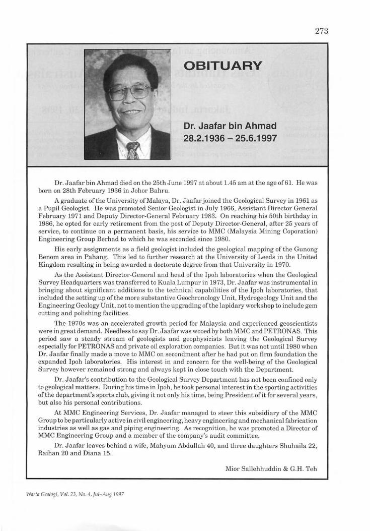
OBITUARY
Dr. Jaafar bin Ahmad 28.2.1936 - 25.6.1997
273
Dr. Jaafar bin Ahmad died on the 25th June 1997 at about 1.45 am at the age of61. He was born on 28th February 1936 in Johor Bahru.
A graduate of the University of Malaya, Dr. Jaafar joined the Geological Survey in 1961 as a Pupil Geologist. He was promoted Senior Geologist in July 1966, Assistant Director General February 1971 and Deputy Director-General February 1983. On reaching his 50th birthday in 1986, he opted for early retirement from the post of Deputy Director-General, after 25 years of service, to continue on a permanent basis , his service to MMC (Malaysia Mining Coporation) Engineering Group Berhad to which he was seconded since 1980.
His early assignments as a field geologist included the geological mapping of the Gunong Benom area in Pahang. This led to further research at the University of Leeds in the United Kingdom resulting in being awarded a doctorate degree from that University in 1970.
As the Assistant Director-General and head of the Ipoh laboratories when the Geological Survey Headquarters was transferred to Kuala Lumpur in 1973, Dr. J aafar was instrumental in bringing about significant additions to the technical capabilities of the Ipoh laboratories, that included the setting up of the more substantive Geochronology Unit, Hydrogeology Unit and the Engineering Geology Unit, not to mention the upgrading ofthe lapidary workshop to include gem cutting and polishing facilities.
The 1970s was an accelerated growth period for Malaysia and experienced geoscientists were in great demand. Needless to say Dr. J aafar was wooed by both MMC and PETRONAS. This period saw a steady stream of geologists and geophysicists leaving the Geological Survey especially for PETRONAS and private oil exploration companies. But it was not until 1980 when Dr. Jaafar finally made a move to MMC on secondment after he had put on firm foundation the expanded Ipoh laboratories. His interest in and concern for the well-being of the Geological Survey however remained strong and always kept in close touch with the Department.
Dr. Jaafar's contribution to the Geological Survey Department has not been confined only to geological matters. During his time in Ipoh, he took personal interest in the sporting activities ofthe department's sports club, giving it not only his time, being President of it for several years, but also his personal contributions.
At MMC Engineering Services, Dr. Jaafar managed to steer this subsidiary of the MMC Group to be particularly active in civil engineering, heavy engineering and mechanical fabrication industries as well as gas and piping engineering. As recognition, he was promoted a Director of MMC Engineering Group and a member of the company's audit committee.
Dr. Jaafar leaves behind a wife, Mahyum Abdullah 40, and three daughters Shuhaila 22, Raihan 20 and Diana 15.
Mior Sallehhuddin & G.H. Teh
Warta Geologi, Vol. 23, No . 4, Jul-Allg 1997
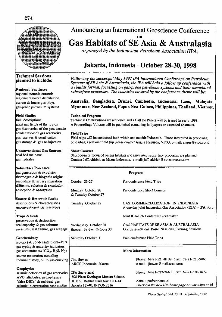
274
Technical Sessions planned to include:
Regional Syntheses regional tectonic controls regional resource distribution current & future gas plays gas-prone petroleum systems
Field Studies field descriptions giant gas fields of the region gas discoveries of the past decade condensate-rich gas reservoirs gas reserves & certification gas storage & gas re-injection
Unconventional Gas Sources coal bed methane gas hydrates
Subsurface Processes gas generation & expUlsion thermogenic & biogenic origins secondary & tertiary migration diffusion, solution & exsolution adsorption & absorption
Source & Reservoir Rocks descriptions & characteristics unconventional gas reservoirs
Traps & Seals preservation & destruction seal capacity & gas columns pressures, seal failure, gas seepage
Geochemistry
Announcing an International Geoscience Coriference on
Gas Habitats of SE Asia & Australasia organized by the Indonesian Petroleum Association (IPA)
Jakarta, Indonesia - October 28-30, 1998
Following the successful May 19971PA International Conferen.ce on Petroleum Systems of SE Asia & Australasia, the IPA will hold a follow up conference with a similar format, focussing on gas-prone petroleum systems and their associated subsurface processes. The countries covered by the conference theme will be:
Australia, Bangladesh, Brunei, Cambodia, Indonesia, Laos, Malaysia Myanmar, New Zealand, Papua New Guinea, Philippines, Thailand, Vietnam
Technical Program Technical Contributions are requested and a Call for Papers will be issued in early 1998. A Proceedings Volume will be published containing full papers or extended abstracts.
Field Trips Field trips will be conducted both within and outside Indonesia. Those interested in proposing or leading a relevant field trip please contact Angus Ferguson, VICO, e-mail: [email protected]
Short Courses Short courses focussed on gas habitats and associated subsurface processes are planned. Contact Jeff Aldrich, at Maxus Indonesia, e-mail: [email protected]
October 23-27
Monday October 26 & Tuesday October 27
Tuesday October 27
Wednesday October 28 through Friday October 30
Saturday October 31
Program
Pre-conference Field Trips
Pre-conference Short Cources
GAS COMMERCIALIZA nON IN INDONESIA A one day joint Indonesian Gas Association (IGA) - IP A Foru
Joint IGA-IPA Conference Icebreaker
GAS HABITATS OF SE ASIA & AUSTRALASIA Oral Presentations, Poster Sessions, Evening Sessions
Post-conference Field Trips isotopes & condensate biomarkers gas typing & maturity indicators t==============================================================1 gas contaminants (C02, H2S, N2) source maturation modeling
More Information
thermal history, oil to gas cracking Jim Howes
Geophysics seismic detection of gas reservoirs AVO, attributes, petrophysics "false DHI's" & residual gas seismic inte retation case studies
ARCO Indonesia, Jakarta
IP A Secretariat 308 Plaza Kuningan Menara Selatan, n. H.R. Rasuna Said Kav. CII-14 Jakarta 12940. INDONESIA
Phone: 62-21-521-8108 Fax: 62-21-521-9063 e-mail: [email protected]
Phone: 62-21-527-3663 Fax: 62-21-520-7672
e-mail [email protected] check out the new lPA home page at: www.ipa.or.id
Warta Geologi, Vol. 23, No.4, Jul-Aug 1997
275
KALENDAR (CALENDAR)
1997
September 1-5 GEOLOGY AND ENVIRONMENT (50th Geological Congress of Turkey), Istanbul, Turkey. (Secretary GEOENV '97 , PK 464, Kizilay, 06424 Ankara, Turkey. Phone: 90312 4343691; telefax: 90 312 4342388; e-mail: [email protected])
September 1-5 IEC '97: FIFTHINTERNATIONALECLOGITE CONFERENCE, Ascona , Switzerland. (Professor V. Trommsdorff and Dr. R. Schmid, Mineralogy lEC 97 , ETH centre, 8092 Zurich, Switzerland. Phone: XX411632 3791; telefax: XX41 1 6321088; e-mail: [email protected]; information and preliminary registration up to 31 October 1996 via http://www/erdw.ethz.ch/ -rolfi')
September 2-4 PALAEONTOLOGY AND STRATIGRAPHY OF SOUTH AMERICA (2 nd European Meeting), in conjunction with the 18th lAS Regional Meeting on Sedimentology), Heidelberg, Germany. (Peter Bengtson, Geologisch-Palaontologisches Institut, 1m Neuenheimer Feld 234, D-69120 Heidelberg, Germany. Phone: 496221548293; telefax: 49 6221548640; e-mail: [email protected]heidelberg. de; WWW: http: //ix .urz.uniheidelberg. del -dc8/ geo/lst-sam.h tml)
September 2-4 SOUTH ATLANTIC MESOZOIC CORRELATIONS (Regional Meeting of IGCP Project 381), Heidelberg, Germany. (Peter Bengtson , Geologisch-Palaontologisch es Institut, 1m Neuenheimer Feld 234, D-69120 Heidelberg, Germany. Phone: 496221548293; telefax : 49 6221 548640 ; e-mail: [email protected];WWW: http ://ix.urz.uni-heidelberg.de/-dc8/geo/lst-381.html)
September 1-5 GEOLOGY AND ENVIRONMENT (Int'l. Symposium), Istanbul, Turkey, by the Chamber of Geological Engineers. (1. Yilmazer, GEOENV
Wartn Geologi, Vo l. 23, No. 4, Jul-Aug 1997
'97, P.K. 464 Kizilay, 06424 Ankara, Turkey. Phone: 9-0-312-4343601; telefax: 9-0-312-4342388; e-mail: [email protected])
September 7-10 AMERICAN ASSOCIATION OF PETROLEUM GEOLOGISTS (International Conference and Exhibition), Vienna, Austria. (AAPG Convention Department, Box 979, Tulsa, OK 74101, USA. Phone: 1/9185602679; telefax: 1/ 918 560 26 84)
September 9-12 OFFSHORE EUROPE '97 (Oil and Gas Exhibition and Conference), Aberdeen, Scotland, UK. (Offshore Europe Partnership, Ocean House, 50 Kingston Road, New Malden, Surrey KT3 3LZ, UK)
September 10-15 FAULTS AND SUBSURFACE FLUID FLOW: FUNDAMENTALS AND APPLICATIONS TO HYDROGEOLOGY AND PETROLEUM GEOLOGY (Geological Society of America Penrose Conference), Albuquerque and Taos, New Mexico. (William C. Haneberg, New Mexico Bureau of Mines and Mineral Resources, New Mexico Institute of Mining and Technology, 2808 Central Avenue SE Albuquerque, NM 87106. E-mail: [email protected])
September 11-14 ALEWECA - ALPINEEVOLUTIONOFTHE WESTERN CARPATHIANS AND RELATED AREAS (International Conference held on the occasion of the 100th anniversary of the birth of Professor D. Andrusov), Bratislava, Slovakia. (Dr. J6sef Hok, Slovak Geological Society, Mlynska Dol, 1, SK-81704, Bratislava, Slovak Republic. Phone: +42-7-3705445; telefax: +42-7-371940; e-mail: [email protected])
September 14-18 EXPLORATION '97 (4th Decennial International Conference), Toronto, Canada. (1. Mac Leod, Geosoft Inc. , Suite 500, 204 Richmond Street W, Toronto, Ontario ON M5H 2G4, Canada)
September 15-25 SOUTHERN NEW ENGLAND OROGEN, AUSTRALIA (SCCS Field and General Meeting
276
1997), Armidale, Australia. (Dr. Ian Metcalf, Department of Geology and Geophysics, University of New England, Armidale, NSW 2351, Australia. Phone: 6167732860; telefax: 6167733300; e-mail: [email protected])
~1~'~("'1~r' _ ..... :fPf~.. _'~~ .. PLACERS AND WEATHERED-ROCK MINERAL DEPOSITS (11th International Symposium), Moscow-Dubna, Russia. (N. Patyk Kara, Institute of Geology of Ore Deposits, Petrography, Mineralogy and Geochemistry of RAS, Staromonetny per., 35, Moscow, 109017, Russia. Phone: 0070952308427; telefax: 007 095 230 2179; e-mail: [email protected])
~':.j~~K~~(~~. . ..... . GROUNDWATER IN THE URBAN ENVIRONMENT (27th IAH Congress) (Professor J.D. Mather, Geology Dept., Royal Holloway and Bedford New College, Egham, Surrey TW20 OEX, UK. Telefax: 784471780)
.;.P"t~:"i~,lj;·:. _,.... .. ~~::,...;~ ... ~. TECTONICS OF CONTINENTAL INTERIORS (Geological Society of America Penrose Conference), Brian Head Resort near Cedar City, Utah. (Michael Hamburger, Dept. of Geological Sciences, Indiana University, Bloomington, IN 47405, USA. E-mail: [email protected])
~~jt~~;filil!'bv·~ ...... :::~~~. CONCEPTS AND MODELS FOR SUSTAINABLE WATER RESOURCES MANAGEMENT (FRIEND '97 Conference on Regional Hydrology), Postojna, Slovenia. (Dr. M. Brilly, FGG Hydraulics Division, Hajdrihova 28, 6100 Ljubljana, Slovenia. Phone: (386) 61 1254 333; telefax: (385) 61 219 987; e-mail: [email protected])
~~pt~~~o .. · ...... f) .....• :
MAIN CHANGES IN THE MARINE AND TERRESTRIALATLANTICREALMDURING THE NEOGENE (2nd Regional Congress), Salamanca, Spain. (Departmento de Geologia (Palaeontologia, Facultad de Ciencias, Universidad de Salamanca, 37008 Salamanca, Spain. Phone: 3423294497; telefax: 3423 394514; e-mail: [email protected]/ [email protected])
l~:::~~ "Bljt~!i:~·:.~ .. 2Y_. ' .. (': .. " .. ENVIRONMENTAL GEOCHEMISTRY (4th International Symposium), Vail, Colorado, USA. (R.C. Severson or L.P. Gough, US Geological Survey, DFC, Box 25046, MS 973, Denver Colorado 80225, USA. Telefax: (1) 303 236 3200)
;'(lgctdber &-10 c.; .. . . ',. .
MATHEMATICAL METHODS IN GEOLOGY (Part of the Mining Pn'bram Symposium), Prague, Czech Republic. (Y. Nemec, Krybnicum 17, 100 00 Praha 10-Strasnice, Czech Republic. Phone: 4227811801; telefax: 4230623169)
'''i~er 1 .. tff~~~:;: TECHNOLOGY AND GLOBALISATION: LEADING THE PETROLEUM INDUSTRY INTO THE 21ST CENTURY (15th World Petroleum Congress), Beijing, China. (Organising Committee, c/o China National Petroleum Corporation, P.O. Box 766, Liu Pu Kang, Beijing 100724, China)
~.···O~2o:i2 'IMPROVED OIL RECOVERY (9th European Symposium), The Hague, The Netherlands. (lOR '97, EAGE, P.O. BOX 298,3700 AG Zeist, The Netherlands)
~Jj~~e!" ~Jt~if~"~~:C(i~:[·~f.::('~.~!r0; '" .. GEOLOGICAL SOCIETY OF AMERICA ANNUAL MEETING, Denver, Colorado, USA. (GSA Meetings Department, P.O. Box 9140, Boulder,C080301, USA. Phone: 8004721988)
rbdOher ~fJ':,;Ii' ....... . PETROLEUM GEOLOGY OF NORTH-WEST EUROPE (5th Conference and Exhibition), London, UK. (CASIL, 4 Cavendish Square, London, W1M OBX, UK. Phone: 44/171 499 0900; telefax: 44/171 629 3233)
c~()Y~JD.b~ H ~. TECTONICS OF EAST ASIA (International Conference & Sino-American Symposium), Chungli, Taiwan. (Dr. Ching-Hua Lo, Department of Geology, National Taiwan University, 245 Choushan Road, Taipei 106, Taiwan, ROC. Telefax: 886-2-3636095; e-mail: [email protected]; www: http:// sun03.gl.ntu.edu.tw/tea.html or Dr. Jean Crespi, Department of Geology and Geophysics, University of Connecticut, Storrs, CT 06269-2045, U.S.A. Phone: 860-486-0601; telefax: 860-486-1838; e-mail: [email protected])
Warta Geologi, Vol. 23, No.4, Jul-Aug 1997
November 12-14 THE 19TH NEW ZEALAND GEOTHERMAL WORKSHOP (Workshop), New Zealand. (c/o Geothermal Institute, The University of Auckland, Private Bag 92019, Auckland, New Zealand. Telefax: 64-9-373 7436; e-mail : geo. [email protected])
November 17-19 APPLIED GEOLOGIC REMOTE SENSING (12th International Conference and Workshop), Denver, Colorado, USA (Robert Rogers, ERIM, Box 134001, Ann Arbor, MI 48113 4001 USA Phone: (1) 313 994 1200; telefax: (1) 313 994 5123; e-mail: [email protected])
November 17-21 DEEP FOUNDATIONS, EXCAVATIONS, GRO UND IMPROVEMENT & TUNNELLING, (Symposium), Bangkok, Thailand. (Prof. AS. Balasubramaniam, The Hon. Secretary General Southeast Asian Geotechnical Society, c/o Asian Institute of Technology, P.O. Box 4, Klong Luang, Pathumthani 12120, THAILAND. Phone: (66-2) 524 5519, (66-2) 524 5537; telefax: (66-2) 516 2126, (66-2) 524 5523)
November 30 - December 3 PERMIAN OF EASTERN TETHYS: BIOSTRATIGRAPHY, PALAEOGEOGRAPHY & RESOURCES (International Conference), Melbourne, Australia. (The Secretariat, Permian of Eastern Tethys Conference, School of Aquatic Science & Natural Resources Management, Deakin University, Rusden Campus, 662 Blackburn Road, Clayton, Victoria 3168, Australia. Phone: 61-3-92447429; telefax: 62-3-92447480; e-mail: [email protected])
1998
CANADIAN INSTITUTE OF MINING, METALLURGY AND PETROLEUM (100th annual general meeting), Quebec, Canada. (John Gaydos, Meetings Manager, Canadian Institute of Mining and Metallurgy, 1 Place Alexis Nihon, 1210-3400 de Maisonneuve Boulevard West, Montreal, Quebec H3Z 3B8, Canada. Phone: (514) 939-2710; telefax: (514) 939-2714)
Wnrtn Geologi, Vol. 23, No . 4, Jul-Aug 1997
277
10TH IAGOD SYMPOSIUM, Australia. (Professor I.R. Plimer University of Melbourne, Parkville, VIC 3052, Australia. Phone: 613 3446520; telefax: 6133447761)
January 28-30 EXPLORATION METHODS '98: PATHWAYS TO DISCOVERY (International Meeting following annual Cordilleran Roundup), Vancouver, Canada. (BC and Yukon Chamber of Mines , Attn. Technical Chair, 840 West Hastings St., Vancouver, British Colombia, Canada V6C 1C8. Telefax: 604 681 2363)
March 23-24 ASIA PACIFIC CONFERENCE ON INTEGRATED MODELLING FOR ASSET MANAGEMENT (Conference), Kuala Lumpur, Malaysia. (SPE Kuala Lumpur Office, Lot F1/ 01, First Floor, Citypoint, Kompleks Dayabumi, J alan Sultan Hishamuddin, 50050 Kuala Lumpur, Malaysia. Phone: 6-03-294-7211; telefax: 6-03-294-5158)
April 13-17 15TH INTERNATIONAL SEDIMENTOLOGICAL CONGRESS , Alicante , Spain. (15th International Sedimentological Congress, Departamento de Cienias de la Tierray Medio Ambiente, Facultad de Ciencias, Campus de San Vicente de Raspeig, Universidad de Alicante, Apardo 99, 03080 Alicante, Spain. Phone: 3465903552; telefax: 3465903552; e-mail: [email protected])
April 13-17 KIMBERLITES (5th International Conference), Cape Town, South Mrica. (J.J. Gurney, 71KC, Department of Geological Sciences, University of Cape Town, Private Bag, Rondebosch 7700, South Mrica. Phone: 2721 531 3162; telefax: 27 21 650 3783; e -mail: [email protected]; URL: http:// www.uct.ac.za/depts/geolsci/71KC/) April 19-23 ---COMPUTER APPLICATIONS IN THE MINERALS INDUSTRY - APCOM '98 (27th International Symposium), London, UK. (Conference Office, Institution of Ming and Metallurgy, 44 Portland Place, London WIN 4BR, UK. Phone: +44 (0)171 580 3802; telefax: +44 (0)171 436 5388; e-mail: [email protected])
278
April 20-22 GEO '98 (Middle East Geosciences Exhibition and Conference), Bahrain. (Stephen Key, Arabian Exhibition Management WLL, P.O. Box 20200, Manama, Bahrain. Phone: 973 550033; telefax: 973 553288)
April 20-23 HYDROLOGY, WATER RESOURCES AND ECOLOGY IN HEADWATERS (International Interdisciplinary Conference - Head-Water '98), Merano, Italy. (HeadWater '98, c/o European Academy, Weggensteinstrasse 12/ A, 1-39100 BozenIBolzano, Italy. Phone: 39471 30 61 11; telefax; 39 471 30 60 99; e-mail: [email protected])
Ju e 8-12 EUROPEAN ASSOCIATION OF GEOSCIENTISTSAND ENGINEERS (EAGE) (60th Conference), Leipsig, Germany. (EAGE, E.H. Bornkamp, P.O. Box 298, NI 3700, AG Zeist, The Netherlands. Phone: 31/3069 62 655; telefax: 3113069 62 640)29)
June 23-25 THE ROLE OF A NATIONAL GEOLOGICAL SURVEYINSUSTAINABLEDEVELOPMENT (International Conference), Gaborone, Botswana. (The Secretariat (Attention: Mr. B.K. Paya), 50th Anniversary Conference, Department of Geological Survey, Private Bag 14, Lobatse, Botswana. Phone: (267) 331721; telefax: (267) 332013; e -mail: [email protected])
June 28 - July 5 GONDWANA 10, Cape Town, South Mrica. (Organising Committee Gondwana 10, Department of Geological Sciences, University of Cape Town, Rondebosch, South Mrica. Phone: 2721650 3171; telefax: 27 21650 3167)
June 29 - July 2 15TH CARIBBEAN GEOLOGICAL CONFERENCE, Kingston, Jamaica. (Dr. Trevor Jackson, c/o Department of Geography and Geology, University of the West Indies, Kingston 7, Jamaica. Telefax; 8099271640)
June 29 - July 18 8TH INTERNATIONAL PLATINUM SYMPOSIUM (IAGOD/CODMUR), Johannesburg, South Mrica. (Dr. C.A. Lee, P.O. Box 68108, Bryanston, South Mrica. Phone:
1127 373 2580; telefax: 1127 836 0371; e-mail: [email protected])
August 10TH IAGOD SYMPOSIUM, Broken Hill, Australia. (Professor LR. Plimer, University of Melbourne, Parkville, VIC 3052, Australia. Phone: 6133446520; telefax; 6133447761)
August 9-15 INTERNATIONAL MINERALOGICAL ASSOCIATION: IMA '98 (17th General Meeting), Toronto, Canada. (Professor A.J. Naldrett, Department of Geology, University of Toronto, Canada M5S 3BI. Phone: (461) 978 3030; telefax: (416) 978 3938; e-mail: [email protected])
August 17-19 GEOSEA '98 (Ninth Regional Congress on Geology, Mineral and Energy Resources of Southeast Asia) , Kuala Lumpur, Malaysia. (The Organising Secretary, G EOSEA '98, Geological Society of Malaysia, c/o Department of Geology, University of Malaya, 50603 Kuala Lumpur, Malaysia. Phone: +(603) 757 7036; telefax: +(603) 759 3900; e-mail: [email protected])
August 17-20 THE JURASSIC SYSTEM (5th International Symposium), Vancouver, Canada. (P.L. Smith, Earth and Ocean Science, University of British Columbia, 6339 Stores Rd., Vancouver, BC, V6T 1Z4 Canada. Phone: (604) 822-6456; telefax: (604) 822 6088; e -mail: [email protected]; WWW: http:// www.eos.ubc.ca/jurassiciannounce.html)
---
~
September 8-10 COASTAL ENVIRONMENT 98 ENVIRONMENTAL PROBLEMS IN COASTAL REGIONS (Conference), Cancun, Mexico. (Liz Kerr, Conference Secretariat, COASTAL ENVIRONMENT 98, Wessex Institute of Technology ,Ashurst Lodge, Ashurst, Southampton, S040 7 AA, UK. Phone: 44 (0) 1703293223; telefax: 44 (0) 1703 292853; e-mail: [email protected]; http://www.wesses.ac.uk)
September 14-17 MODERN EXPLORATION AND IMPROVED OIL AND GAS RECOVERY METHODS (2nd International Conference), Krakow, Poland. (DEXTER Congress and Symposium Bureau, Wroclawska 37A, 30-011 Krakow, Poland.
Warta Geologi, Vol. 23, No.4, Jul-Aug 1997
Phone: 4812340808; telefax: 4812336313; email: [email protected])
October 26-29 GEOLOGICAL SOCIETY OF AMERICA ANNUAL MEETING , Toronto , Ontario, Canada. (GSA Meetings Department, P.O. Box 9140, Boulder CO, 80301 USA. Phone: 800472 1988)
October~oveD1ber PHYSICAL, CHEMICAL AND BIOLOGICAL ASPECTS OF AQUIFER-STREAM SEDIMENT INTERRELATIONS (28th IAH Congress) (Dr. J . Rosenschein, USGS MS 414, National Center, Reston Va 22092 , USA; Telefax: 7036485722)
November 16-20 THIRTEEN SOUTHEAST ASIAN GEOTECHNICAL CONFERENCE (Conference), Taipei, Republic of China. (Dr. John Chien-Chung Li, Secretary General/ SEAGC 13, c/o Public Construction Commission, Executive Yuan, Fl. 9, No. 4, Chung Hsiao West Road, Sec. 1, Taipei, Taiwan, Republic of China. Phone: 886-2-388-4962; telefax: 886-2-388-4959; e-mail: [email protected])
Wnrtn Geologi, Vol. 23, No . 4, JIlI-Allg 1997
279
1999
August 4-12 AFRICA, CRADLEOFHUMANKlNDDURING THE QUATERNARY (XV INQUA Congress), Durban, South Africa. (ProfessorT.C. Partridge, Climatology Research Center, University of Witwatersrand, 13 Cluny Rd, Forest Town, Johannesburg 2193, South Mrica. Phone: +27 11 646 3324; telefax: +27 11 486 1689; e-mail: 141 [email protected])
August 14-25 CARBONIFEROUS-PERMIAN (XIV International Congress), Calgary, Alberta, Canada. (Dr. Charles Henderson, Associate Professor , Department of Geology and Geophysics, The University of Calgary, N.W. Calgary, Alberta, Canada T2N 1N4. Phone: 403 220 6170; telefax: 403 285 0074; e-mail: [email protected])
PP 3279/11/93 ISSN 0126-6187
rID l]] lli~1f1===:l
GEOLOGICAL SOCIETY OF MAL""YSIA
JP~~~'1rlDJ~ @~(Q)ILCQ)@TI
BIBLIOGRAPHY AND INDEX PUBLICATIONS OF THE
GEOLOGICAL SOCIETY OF MALAYSIA 1967 - 1993
1993
Compiled by
NG THAM FAIT
u//etin 0/ lite GEOLOGICAL SOCIETY OF MALAYSIA
Cheques, Money Orders or Bank Drafts must PRI CE: accompany all orders. Orders will be invoiced
The Hon. Assistant Secretary GEOLOGICAL SOCIETY OF MALAYSIA c/o Dept. of Geology, University of Malaya 50603 Kuala Lumpur, MALAYSIA
for postage and bank charges. Orders should RM30.00 be addressed to:
PP 3279/11/93 ISSN 0126-6187
rn LWLk~'1ril GEOLOGICAL SOCIETY OF MALAYSIA
IP~~~'1rlDJ~ @~@ILCQ)@TI
KANDUNGAN (CONTENTS)
1-5 Kewujudan Formasi Lambir di SinkHn Vlu Bok, Sarawak Viara Lim Chun Hui and Mohd. Shafeea Leman
7-13 Potential Alkali-Silica reaction in some Malaysian rock aggregate and their test results Sazali Yaacob. Yeap Ee Beng and Hashim Abdul Razak
15-23 Geology and related activities in the construction of Batu Dam, Kuala Lumpur Saim Suratman
25-35 Kinematic analysis of striated fractures in Titiwangsa granitoid, Karak Highway - Selangor side H.D. Tjia
37-46 A stratigraphic log of Semanian Formation along part of the Meniakab-Temerloh Bypass, Pahang I. Metcalfe and K.R. Chakraborty
47-59 Microstructures ofthe deformed granites of eastern Kuala Lumpur - implications for mechanisms and temperatures of deformation Ng Tham Fall
61-68 Seismic and borehole analysis of Pantai Kundor, Melaka Abd. Rahim Sam udin and Umar Hamzah
69-77 Engineering properties or granitic soils and rocks of Penang Island, Malaysia Tan Boon Kong
79-96 Comparative geochemistry ofthesedimeniary and metasedimeniary clastic rocks of the Kuanian area, Pahang, Malaysia Sidibe Yaya Tiemoko. Tan Teong Hing and Ahmad Jantan
97-112 The sedimentology and tectonics orthe Temburong Formation - deformation of early Cenozoic deltaic sequences in W Borneo Robert B. Tate
113-121 The significance of Upper Permian brachiopods from Merapuh area, northwest Pahang Mohd Shafeea Leman
123-133 Application of soil geochemistry to the detection ofSb-Au mineralization in the Buffalo Reef area, Kuala Medang, Pahang J.J . Pereira, E.B. Yeap and T.F. Ng
135-144 Characterisation of the weathering profile developed over an amphibole schist bedrock in Peninsular Malaysia J.K. Raj
145-155 Geology or the Gunung Danum conservation area: Geocllemistry and soil aspects Muhamad Barzani Gasim, Dale Brunotte. Sahibin Abdul Rahim. Sahat Sadikun and Sanudin Tahir
157-168 Joint spacing of granitic rocks in the eastern Kuala Lumpur area, Peninsular Malaysia Ng Tham Fan
169-174 Kajian geofizik di Kuala Betis, Kelantan Abdu l Rahim Samsudin, Kamal Roslan Mohamad, Ibrahim Abdullah dan Ab. Ghani Rafek
Editor: G.H. Teh
ulletin 0/ tk GEOLOGICAL SOCIETY OF MALAYSIA
Cheques, Money Orders or Bank Drafts must accompany all orders. Orders will be invoiced for postage and bank charges. Orders should be addressed to :
PRICE:
RM35.00
The Han. Assistant Secretary GEOLOGICAL SOCIETY OF MALAYSIA c/o Dept. of Geology, University of Malaya 50603 Kuala Lumpur, MALAYSIA
PP 3279/11/93 ISSN 0126-6187
@&§~il TID~~~'1rlDJ~
@~cQ)ILCQ)@II
SPECIAL ISSUE ON PETROLEUM GEOLOGY VOL. VIII KANDUNGAN (CONTENTS)
1-9 Relationship of gabbro and pillow lavas in the Lupar Formation, West Sarawak: Implications for inteqJretation of the Lubok Antu Melange and the Lupar Line N.S. Haile, S.K. Lam and R.M. Banda
11-18 Post migration processing of seismic data Dashuki Mohd.
19-30 The stratigraphy of northern Labuan, NW Sabah Basin, East Malaysia Mazlan B. Hj . Madon
31-53 Depositional and diagenetic histories 01' reservoir sandstones in the Jerneh field , central Malay Basin Mazlan B. Hj. Madon
55-59 Improved characterisation of carbonate reservoirs using non-linear modelling M. Prins
61-65 Borehole gravimetry survey in Central Luconia carbonate reservoirs Mah Kok Gi n and Frans van den Berg
67-80 Structural development at the west-central margin of the Malay Basin Liew Kit Kong
81-91 Abnormal pressure occurrence in the Malay and Penyu basins, ofl'shore Peninsular Malaysia - a regional understanding Mohd Shariff Bin Kader
93-104 A quantitative study of the seismic time-amplitude reflection characteristics in an oil field Ng Tong San, Idrus Mohd Shuhud and Leong Lap Sau
105-117 Application of sequence stratigraphic techniques on the non-marine sequences: An example from the Balingian Province, Sarawak Ismail Che Mat Zin and laafar Sipan
119-126 Inversion tectonics in the Malay Basin: evidence and timing of events H.D. Tjia
127-143 Dent Group and its equivalent in the ofTshore Kinabatangan area, East Sabah Ismail Che Mal Zin
145-156 Complex transtensional structures and the hydrocarbon potential of the Greater Sarawak Basin, Sarawak as defined by synthetic aperture radar M.P.R. Light, DJ. Bird, G.A. Posehn and M.A.A. Hudi
157-161 Melange on the Jerudong Line, Brunei Darussalam, and its regional signilicance Charles S. Hutcllison
162-174 Geothermics of the Malaysian sediment.~ry basins Mohd Firdaus Abdul Halim
175-186 Tectonic implications of well-bore breakouts in Malaysian basins H.D. Tjia and Mohd Idrus Ismail
Editor: G.H. Teh
ulletin 0/ Ik GEOLOGICAL SOCIETY OF MALAYSIA
Cheques, Money Orders or Bank Drafts must accompany all orders. Orders will be invoiced for postage and bank charges. Orders should be addressed to:
PRICE:
RM50.00
The Hon. Assistant Secretary GEOLOGICAL SOCIETY OF MALAYSIA c/o Dept. of Geology, University of Malaya 50603 Kuala Lumpur, MALAYSIA
GEOLOGICAL SOCIETY OF MALAYSIA PUBLICATIONS BULLETIN OF THE GEOLOGICAL SOCIETY OF MALAYSIA
W ARTA GEOLOGI - NEWSLETIER OF THE GEOLOGICAL SOCIETY OF MALAYSIA
ADVERTISING SPACE ORDER FORM
W ARTA GEOLOGI BULLETIN Format: 20 cm x 28 cm Format: 20 cm x 28 cm
RATES: Black & White Colour Black & White Colour
Inside full page per issue RM300 RM600 RMl,OOO RMl,500 Inside half page per issue RM200 RM500 RM500 RM800 Inside full page for 6 issues RMl,500 RM3,000 - -
Inside half page for 6 issues RMl,OOO RM2,500 - -
Artwork and positive films or slides (for colour or black & white) should be supplied by the advertiser.
Please send the completed form below together with remittance payable to "Geological Society of Malaysia" to
The Editor, Geological Society of Malaysia c/o Dept. of Geology, University of Malaya, 50603 Kuala Lumpur, Malaysia.
For further information, please ring 603-7577036 or fax 603-7563900.
r-------------------------------------The Editor, Geological Society of Malaysia c/o Dept. of Geology, University of Malaya, 50603 Kuala Lumpur.
We would like to take up advertising space in WARTA GEOLOGIJBULLETIN in the form (please tick as appropriate):
WARTA GEOLOGI BULLETIN Black & White Colour Black & White Colour
Inside full page one issue 0 one issue 0 one issue 0 one issue 0 six issues 0 six issue 0 issues 0 issues 0
Inside half page one issue 0 one issue 0 one issue 0 one issue 0 six issues 0 six issue 0 issues 0 issues 0
ArtworkIPositive filmlslide* enclosed 0 not enclosed 0 Company ... .. ..... .. ... .. .. ...... . .... ..... ........ .. .. . .. ...... .. .. ..... ....... ..... .. ... ......... .. ... ......... . . ... .. .. ...... ............... ... .. .
Address .. .... ... ... .. . .. .. .. .. .. .. ... .. ..................................................... ........................... .............. . ................ .
Enclosed cheque/money orderlbank draft* .. ...................... .. .. .. .. . ... . .. for RM .. .. ... .. ... ....... .. .. . .. .. . .. .... .. .. . . .
Person to be contacted ... ...... . ... .......... ..... .. ............ ....... .. ....... . . ...... Tel:
Designation .. ..... ... ... .. . ... ... . . .. .... .. .. ... ...... ... .. ... .... . .... . ..... ......... ...... Fax:
* Please delete as appropriate. Signature . .. ..... . ...... . ...... ..... .. . ........ .
ORDER FORM
GEOLOGICAL SOCIETY OF MALAYSIA PUBLICATION
The Assistant Secretary, Geological Society of Malaysia, c/o Department of Geology, University of Malaya, 50603 Kuala Lumpur, MALAYSIA
Dear Sir,
Date: ....................... .
Please send me the following publications. I enclose US$/RM* .......................... . in cheque/money orderlbank draft. *
Item No. of Copies Price
.. --I-----~ .. -........ -.. -.-.---.---.-...... . .... -..... -... -... -.--------
. __ . __ ._ .. _----_._._-----
--........ ----.-.-.. -- - ---.- - --.... --.. ---... --.--- ---.---.... - .. -.---..... -.---.t-------... -.----.... ---- .. -.. -......... -----------.. --.. -.. - .............. ---.-. ----
-----------·---------~----··--···-·--····--·i-------·--- .. -.-.-... -.-.. -- -------------.-... ------.----
------------------_ .. __ .. _-----_.- - _._.- -_ .. __ ._._--\--------_._-_ .. _-_._----_ .. __ . __ ._-_ .. ----_._----_._ ...... _ ....... _ ..... _---
......... _. __ ._ .... _-_.-.- -.-----.-.----.-~- ... -.... - ......... _ .. -.. - _ ... _-----._. __ ._-_.- .......... __ . -- . --_._-----_. __ ........ .
*Delete where applicable
Please mail to : (Please print)
-'-----_ ..... _ ... _. __ ... __ .... _--------_ .. _ ... _ ... _-- --.-.--.-----~ ...
Sub-Total
Total
Signature: _______ ...... .
-----..... -.-.-... -.... ---.--.. -.--.---.-.----...... ----
GEOLOGICAL SOCIETY OF MALAYSIA PUBLICATIONS . .
General Information Papers should be as concise as possible. However, there is no fIxed limit as to the length and number of illustrations. Normally, the whole paper should not exceed 30 printed pages. The page size will be 204 x 280 mm (8 x 11 inches).
The fInal decision regarding the size of the illustrations, sections of the text to be in small type and other matters relating to printing rests with the Editor.
The fInal decision of any paper submitted for publication rests with the Editor who is aided by a Special Editorial Advisory Board. The Editor may send any paper submitted for review by one or more reviewers. Authors can also include other reviewers' co=ents of their papers. Scripts of papers found to be unsuitable for publication may not be returned to the authors but reasons for the rejection will be given. The authors of papers found to be unsuitable for publication may appeal only to be Editor for reconsideration if they do not agree with the reasons for rejection. The Editor will consider the appeal together with the Special Editorial Advisory Board.
Unless with the consent ofthe Editor, papers which have been published before should not be submitted for consideration.
Authors must agree not to publish elsewhere a paper submitted and accepted.
Authors alone are responsible for the facts and opinions given in their papers and for the correctness of references etc.
One set of proofs will be sent to the author (if time permits), to be checked for printer's errors. In the case oftwo or more authors, please indicate to whom the proofs should be sent.
Twenty-fIve reprints of each article published are supplied free-of-charge. Additional reprints can be ordered on a reprint order form, which is included with the proofs.
Correspondence: All papers should be submitted to
The Editor (Dr. Teh Guan Hoe) Geological Society of Malaysia
c/o Geology Department University of Malaya 50603 Kuala Lumpur
MALAYSIA Tel: (603) 7577036 Fax: (603) 7563900
Script Requirements Scripts must be written in Bahasa Malaysia (Malay) or English.
Two copies ofthe text and illustrations must be submitted. The scripts must be typewritten double-spaced on paper not exceeding 210 x 297 mm (or 8.27 x 11.69 inches, A4 size). One side of the page must only be typed on.
Figure captions must be typed on a separate sheet of paper. The captions must not be drafted on the fIgures. The fIgure number should be marked in pencil on the margin or reverse side.
Original maps and illustrations or as glossy prints should ideally be submitted with suffIciently bold and large lettering to permit reduction to 18 x 25 cm: fold-outs and large maps will be considered only under special circumstances.
Photographs should be of good quality, sharp and with contrast. For each photograph, submit two glossy prints, at least 8 x 12.5 cm and preferably larger. Use of metric system of measurements (S1) is strongly urged wherever possible.
An abstract in English which is concise and informative is required for each paper.
References cited in the text should be listed at the end of the paper and arranged in alphabetical order and typed double-spaced. The name ofthe book or journal must be in italics. The references should be quoted in the following manner:
HAMILTON, W., 1979. Tectonics of the Indonesian region. U.S. Geological Survey Professional Paper 1078, 345p.
HOSKING, KF.G., 1973. Primary mineral deposits. In Gobbett, D.J. and Hutchison, C.S. (Eds.), Geology of the Malay Peninsula (West Malaysia and Singapore). Wiley-Interscience. New York, 335-390.
HUTCHISON, C.S., 1989. Geological Evolution of South-east Asia. Clarendon Press, Oxford. 368p.
SUNTHARALINGAM, T. , 1968. Upper Paleozoic stratigraphy of the area west of Kampar, Perak. Geoz. Soc. Malaysia Bull. 1, 1-15.
TAYLOR, B., AND HAYES, D.E., 1980. The tectonic evolution ofthe South China Sea basin. In: D.E. Hayes (Ed. ), The Tectonic and Geologic Evolution of Southeast Asian Sea and Islands, Part 2. Am. Geophy. Union Monograph 23,89-104.
Submission of electronic text. In order to publish the paper as quickly as possible after acceptance, authors are requested to submit the fInal text also on a 3.5" diskette. Both Macintosh and PC (DOSlWindows) platforms are supported. Main text, tables and illustrations should be stored in separate fIles with clearly identifIable names. Text made with most word processors can be readily processed but authors are advised to provide an additional copy of the text fIle in ASCII format. Preferred format for illustration is Encapsulated PostScript (EPS) but authors may submit graphic fIles in their native form. It is essential that the name and version of softwares used is clearly indicated. The fInal manuscript may contain parts (e.g. formulae, complex tables) or last-minute corrections which are not included in the electronic text on the diskette; however, this should be clearly marked in an additional hardcopy of the manuscript. Authors are encouraged to ensure that apart from any such small last-minute corrections, the disk version and the hardcopy must be identical. Discrepancies can lead to proofs of the wrong version being made.
Ni~ ~
siberu~ SUMATRA
100° E
\ 'L.-.c-... .. u ..... ODIA r' \'VIETNAM
,-.~ ,r
Terengganu
~ingga
OSingkep
200km
LAUT CHINA SELATAN (South China Sea)
o Natuna
Belitung
110° E
NEGERI-NEGERI MALAYSIA (STATES OF MALAYSIA)
1 PERLIS 8 PAHANG 2 KEDAH 9 NEGERI SEMBILAN 3 PULAU PI NANG 10 MELAKA 4 PERAK 11 JOHOR 5 KELANTAN 12 $ABAH 6 TERENGGANU 13 SARAWAK 7 SELANGOR
(j,. Banggi
KALIMANTAN