incision of rivers in pleistocene gravel and conglomeratic
TRANSCRIPT

Incision of rivers in Pleistocene gravel and conglomeratic terraces: Further circumstantial evidence for the uplift of Borneo during the
Neogene and Quaternary
Franz L. KessLer1* & John Jong2
1Independent Geoscience, Oil and Gas Consultant2JX Nippon Oil and Gas Exploration (Deepwater Sabah) Limited
Level 51, Menara 3 PETRONAS, Persiaran KLCC, Kuala Lumpur City Centre, 50088 Kuala Lumpur*Corresponding author: [email protected]
Abstract: Incised Pleistocene gravel beds and conglomerates are a common feature of the Baram, Limbang and Temburong drainage systems in NW Sarawak and Brunei. Incision values vary from 9 to 76 m, a likely result of strong temporary precipitation, in combination with ongoing uplift. Conglomerates and gravels are monomictic, almost exclusively formed by the Lower Miocene Meligan sandstone, and deposited in nested fluvial terraces. The described pattern differs from coastal terraces of the Miri area; the latter do not contain conglomerates other than locally-derived and recycled quartz clasts. The available age and uplift data, when plotted log-normal, suggest that the mountainous central Borneo uplift was continuous of some 6-7 mm a-1, whilst low-lying coastal wetland areas in Brunei and Sarawak may only have seen a very minor uplift in the order of 0.8 mm a-1. The uplift may be ongoing at the present day.
Keywords: NW Borneo, Neogene, Quaternary, terraces, uplift, Sarawak, Brunei, geomorphology
INTRODUCTIONThis paper is in many ways a compilation, given there
is a need to align older data with modern results, and from different branches of science. The areas of studies comprise the greater onshore Baram Delta, coastal Brunei and hinterlands in both Sarawak and Brunei (Figure 1). Incision can be a result of either an increase of precipitation, or uplift of the drainage system which leads to a higher river gradient. The contemporary Baram, Limbang and Temburong Rivers only carry silt and occasional sand, but no longer fist-size rounded rock pebbles, as can be seen in Quaternary river terraces (Figure 2).
The influence of climate parameters on uplift and erosion has been demonstrated by Shroder and Bishop (2009) on the Nanga Parbat Himalaya during Late Cenozoic time. In that paper, the authors hypothesize that the Nanga Parbat pop-up structure was initiated at ca. 10-12 Ma before present (BP), comparable to the almost co-eval age of uplift and shelf development in Borneo (e.g., Kessler and Jong, in prep.), with un-roofing ongoing at least until the Late Pleistocene. Furthermore, it has been shown by Whipple (2009), that the internal dynamics of actively deforming collisional mountain ranges are influenced by climate in other parts of the world as well. Triggered by a climate-driven increase in erosion rate, friction-dominated mountain ranges are expected to show a number of simultaneous responses: a decrease in the width of the range, a temporary increase in sediment yield, a persistent increase in the rate of rock uplift and a reduction in the subsidence rate of surrounding basins.
The most convincing field evidence for such a coordinated response of a mountain range to climate change is made by Whipple (2009) on examples from the European Alps and the St. Elias range of Alaska. Such
research poses the question, to which extent climate may have prompted the rise the Borneo hinterlands, as well as mountainous regions of Sulawesi, New Guinea and other areas of South East Asia.
Cottam et al. (2013) described thermo-chronological data from the Mount Kinabalu (Sabah, NW Borneo) granite, emplaced between ca. 7.2 and 7.8 Ma BP; these provide a unique record of northern Borneo’s exhumation during the Neogene. Biotite 40Ar/39Ar ages (ca. 7.32–7.63 Ma BP) record rapid cooling of the granite in the Late Miocene as it equilibrated with ambient crustal temperatures. Zircon fission-track ages (ca. 6.6–5.8 Ma BP) and apatite (U–Th–Sm)/He ages (central age ca. 5.5 Ma BP) indicate
Figure 1: Tectonic overview map after Cullen (2010). The exact course of the West Baram Line (WBL) remains an arduous topic of discussion – field work carried out by the authors suggest the WBL (dark dashed; Kessler, 2010) merges with the tectonically controlled basin onlap curve (dashed purple).
Bulletin of the Geological Society of Malaysia, Volume 61, December 2015, pp. 49 – 57
Franz L. KessLer & John Jong
Bulletin of the Geological Society of Malaysia, Volume 61, December 201550
rapid cooling during the Late Miocene–Early Pliocene. This cooling reflects exhumation of the granite, uplift and erosion bringing it closer to the Earth’s surface. Thermo-chronological age versus elevation relationships suggest exhumation rates of more than 7 mm a-1 during the latest Miocene and Early Pliocene. This very strong single data point will be compared with uplift data obtained from other sources.
INLAND BORNEO TERRACESIn this paper, we examine NW Borneo Quaternary
terraces and plateaus that saw later incision. Earlier papers by the authors were focussing on terraces of the Miri area, which do not contain conglomerates other than locally-derived and recycled quartz clasts (Kessler & Jong, 2011, 2014).
According to Walther Penck’s classic model/application, landform development depends on the rate of uplift (cited in Chapter 21, Chorley et al., 2005). He saw three main types of landform and landscape development: those developed in places with a low rate of uplift, intermediate forms
developed in places of moderate uplift, and Alpine forms developed on places of rapid uplift. In NW Borneo, all three landform types may be expressed. The terraces belonging to the Baram, Limbang and Temburong (BLT) show the characteristics of alpine style, but nested fill terraces. These are the result of the valley filling with alluvium, the alluvium being incised, and the valley filling again with eroded material, but to a lower level than before. After a terrace gets eroded and incised, there may be little left – a few remnants perched against the country rock, and the terrace that results for the second filling is a nested terrace because it has been “re-nested” into the original alluvium and created a terrace.
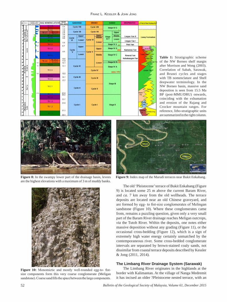
The BLT carry conglomerates and gravels (with rare exceptions) from one single source only: the Lower Miocene Meligan Formation, modestly compacted cross-bedded sandstone (Hutchison, 2005 p. 355) that forms escarpments and cliffs south of the Brunei Bay. The studied intervals are referred to Cycle VIII as shown in Table 1.
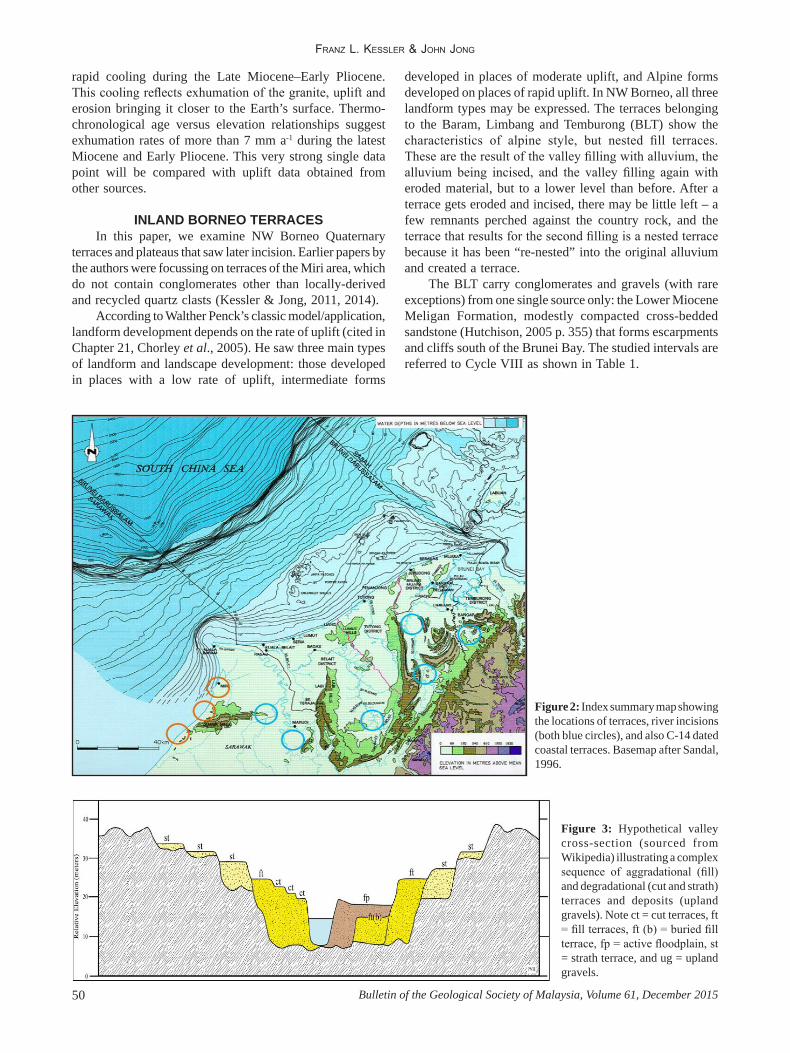
Figure 2: Index summary map showing the locations of terraces, river incisions (both blue circles), and also C-14 dated coastal terraces. Basemap after Sandal, 1996.
Figure 3: Hypothetical valley cross-section (sourced from Wikipedia) illustrating a complex sequence of aggradational (fill) and degradational (cut and strath) terraces and deposits (upland gravels). Note ct = cut terraces, ft = fill terraces, ft (b) = buried fill terrace, fp = active floodplain, st = strath terrace, and ug = upland gravels.
IncIsIon of rIvers In PleIstocene gravel and conglomeratIc terraces
51Bulletin of the Geological Society of Malaysia, Volume 61, December 2015
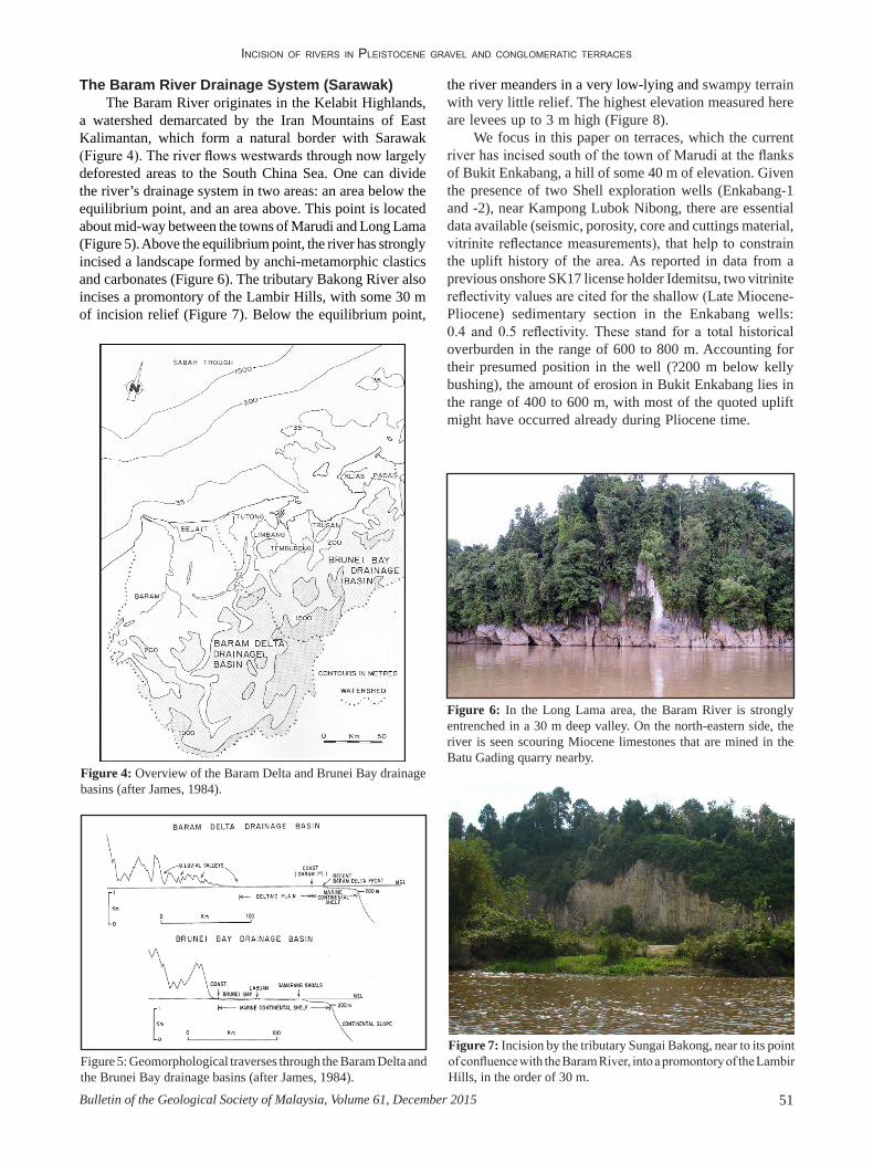
Figure 4: Overview of the Baram Delta and Brunei Bay drainage basins (after James, 1984).
Figure 5: Geomorphological traverses through the Baram Delta and the Brunei Bay drainage basins (after James, 1984).
The Baram River Drainage System (Sarawak)The Baram River originates in the Kelabit Highlands,
a watershed demarcated by the Iran Mountains of East Kalimantan, which form a natural border with Sarawak (Figure 4). The river flows westwards through now largely deforested areas to the South China Sea. One can divide the river’s drainage system in two areas: an area below the equilibrium point, and an area above. This point is located about mid-way between the towns of Marudi and Long Lama (Figure 5). Above the equilibrium point, the river has strongly incised a landscape formed by anchi-metamorphic clastics and carbonates (Figure 6). The tributary Bakong River also incises a promontory of the Lambir Hills, with some 30 m of incision relief (Figure 7). Below the equilibrium point,
Figure 6: In the Long Lama area, the Baram River is strongly entrenched in a 30 m deep valley. On the north-eastern side, the river is seen scouring Miocene limestones that are mined in the Batu Gading quarry nearby.
Figure 7: Incision by the tributary Sungai Bakong, near to its point of confluence with the Baram River, into a promontory of the Lambir Hills, in the order of 30 m.
the river meanders in a very low-lying and swampy terrain with very little relief. The highest elevation measured here are levees up to 3 m high (Figure 8).
We focus in this paper on terraces, which the current river has incised south of the town of Marudi at the flanks of Bukit Enkabang, a hill of some 40 m of elevation. Given the presence of two Shell exploration wells (Enkabang-1 and -2), near Kampong Lubok Nibong, there are essential data available (seismic, porosity, core and cuttings material, vitrinite reflectance measurements), that help to constrain the uplift history of the area. As reported in data from a previous onshore SK17 license holder Idemitsu, two vitrinite reflectivity values are cited for the shallow (Late Miocene-Pliocene) sedimentary section in the Enkabang wells: 0.4 and 0.5 reflectivity. These stand for a total historical overburden in the range of 600 to 800 m. Accounting for their presumed position in the well (?200 m below kelly bushing), the amount of erosion in Bukit Enkabang lies in the range of 400 to 600 m, with most of the quoted uplift might have occurred already during Pliocene time.
Franz L. KessLer & John Jong
Bulletin of the Geological Society of Malaysia, Volume 61, December 201552
Figure 8: In the swampy lower part of the drainage basin, levees are the highest elevations with a maximum of 3 m of muddy banks.
Table 1: Stratigraphic scheme of the NW Borneo shelf margin after Morrison and Wong (2003). Correlation of Sabah, Sarawak, and Brunei cycles and stages with TB nomenclature and Shell deepwater terminology. In the NW Borneo basin, massive sand deposition is seen from 15.5 Ma BP (post-MMU/DRU) onwards, coinciding with the exhumation and erosion of the Rajang and Crocker mountain ranges. For reference, litho-stratigraphic units are summarized in the right column.
Figure 9: Index map of the Marudi terraces near Bukit Enkabang.
The old ‘Pleistocene’ terrace of Bukit Enkabang (Figure 9) is located some 25 m above the current Baram River, and ca. 7 km away from the old wellheads. The terrace deposits are located near an old Chinese graveyard, and are formed by egg- to fist-size conglomerates of Melingan sandstone (Figure 10). Where these conglomerates came from, remains a puzzling question, given only a very small part of the Baram River drainage reaches Meligan outcrops, via the Tutoh River. Within the deposits, one notes either massive deposition without any grading (Figure 11), or the occasional cross-bedding (Figure 12), which is a sign of extremely high water energy certainly unmatched by the contemporaneous river. Some cross-bedded conglomerate intervals are separated by brown-stained coaly sands, not dissimilar from coastal terrace deposits described by Kessler & Jong (2011, 2014).
The Limbang River Drainage System (Sarawak)The Limbang River originates in the highlands at the
border with Kalimantan. At the village of Nanga Medremit it has incised an older ?Pleistocene nested terrace, with an
Figure 10: Monomictic and mostly well-rounded egg-to- fist-size components form this very coarse conglomerate (Meligan sandstone). Coarse sand fills the space between the large components.

IncIsIon of rIvers In PleIstocene gravel and conglomeratIc terraces
53Bulletin of the Geological Society of Malaysia, Volume 61, December 2015
incision measured in the order of 12 m (Figure 13). The conglomerates are very similar to those seen on the Baram near Marudi, albeit a little smaller (bird-egg size, Figure 14).
The Temburong River System (Brunei)The Temborong drainage area occupies some 1100 km2,
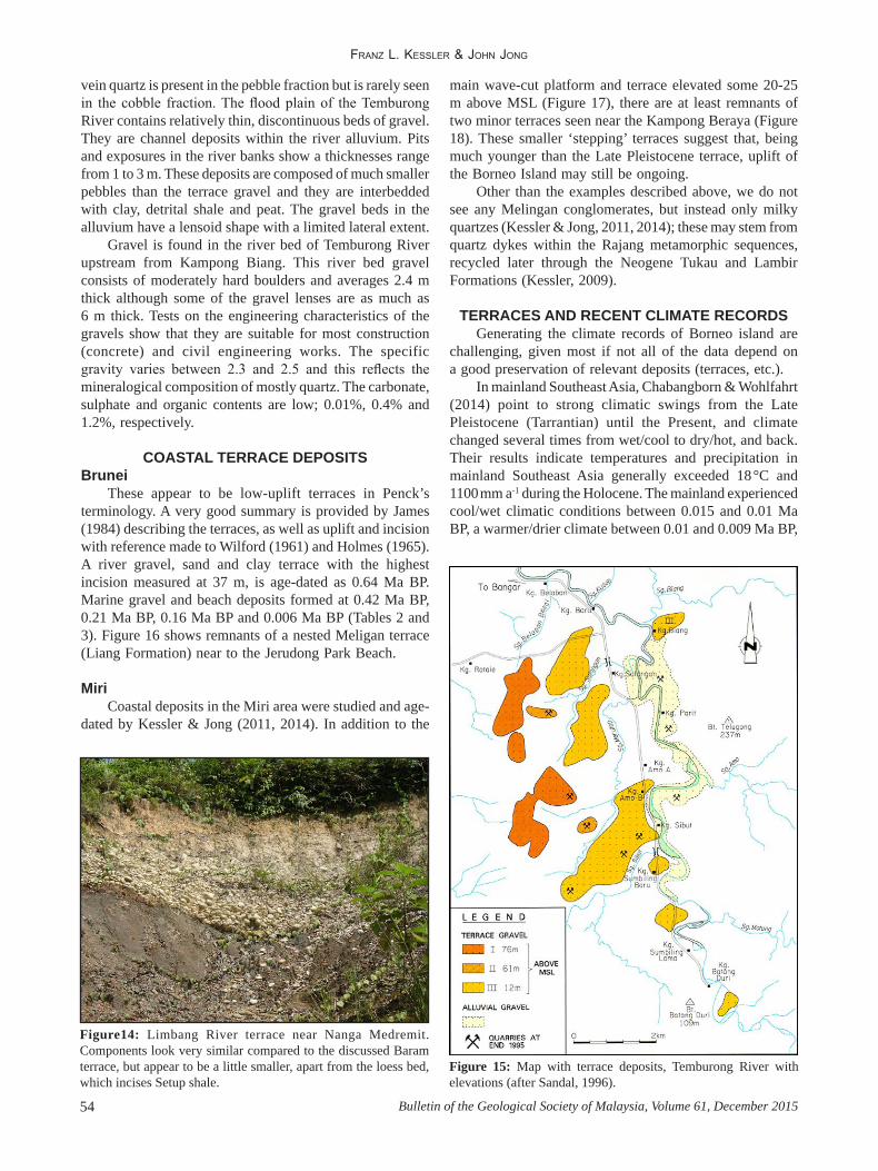
and drains nearly the whole of the Estern Brunei Temburong district. Significant information for this area originates from a Brunei Shell Petroliam website, which refers to a 1996 revised Shell study (Sandal, 1996). The Temburong gravel consists mainly of Meligan sandstone (Early Miocene age) which outcrops in the headwaters of the Temburong River between Bukit Tudal and Bukit Lesong. The parent rock is generally a grey, fine-grained sandstone, but some coarser sandstones and occasional interbedded conglomerates also occur. The gravel was transported downstream during Pleistocene times and deposited in terraces over a relatively flat river valley floor between Bukit Teluggong and the Pandaruan River in Limbang, Sarawak (Figure 15). These terraces contain the bulk of the gravel reserves in the Temburong district. Smaller deposits are found in the flood plain of the Temburong River and in the channel of this river upstream of Kampong Biang.
The main gravel terraces are located to the west of the Temburong River, except near Kampong Batang Duri and Kampong Biang, where two small terraces are located to the east. There are three well-defined terraces. Terrace I, at approximately 76 m above MSL, is the oldest and has an average gravel thickness of 1.8 m. The youngest Terrace III, at 12 m above MSL, is the most laterally extensive with gravel thickness of 1.5 to 3.8 m. Scattered remnants of middle Terrace II, at 61 m above MSL, are located to the east of the high terrace. These deposits are small and not commercially attractive.
The terraces have a flat top and relatively steep sides. The top surface is generally level but often dips at a gentle angle to the east. Gravel is invariably exposed on the sides of the terrace. The overburden thickness varies from 0.2 to 2.4 m and consists of white sand overlain by sandy clay soils. The soils are poor for agriculture and only support a thin primary forest. The gravel lies directly on undulating Setap Shale ‘bedrock’. Post-depositional weathering is seen on all the terraces, the higher one to a greater degree than the lower one.
The size of components of the gravel ranges from a few centimetres to boulders with a maximum diameter of 48 cm. Approximately 40% of the gravel is between 10 and 18 cm in diameter. The proportion of boulders decreases away from the source, with a transition from cobble to pebble gravel (Wentworth scale) towards the north.
The gravel is grey in colour and usually homogenous. The shape of the gravel is largely determined by the joints and bedding planes of the parent material (Meligan sandstone). Bedding traces, if present, are usually parallel to the longest axis of the pebble. Boulders are less symmetrical than the cobbles and pebbles. The composition of boulders, cobbles and pebbles is a fine- to medium-grained sandstone. White
Figure 11: The ‘nested’ terrace is several meters thick and there is little grading if any in this section of the quarry.
Figure 12: In one location, near to the old Chinese graveyard, cross-bedded conglomerates can be seen. These form in areas of extremely high water energy. The brown sands intercalated between the conglomerate beds show a strong similarity with coastal deposits of the Miri area (after Kessler & Jong, 2014).
Figure 13: Incised Meligan sandstone conglomerate on the Limbang River, near Kampong Nanga Medremit.
Franz L. KessLer & John Jong
Bulletin of the Geological Society of Malaysia, Volume 61, December 201554
vein quartz is present in the pebble fraction but is rarely seen in the cobble fraction. The flood plain of the Temburong River contains relatively thin, discontinuous beds of gravel. They are channel deposits within the river alluvium. Pits and exposures in the river banks show a thicknesses range from 1 to 3 m. These deposits are composed of much smaller pebbles than the terrace gravel and they are interbedded with clay, detrital shale and peat. The gravel beds in the alluvium have a lensoid shape with a limited lateral extent.
Gravel is found in the river bed of Temburong River upstream from Kampong Biang. This river bed gravel consists of moderately hard boulders and averages 2.4 m thick although some of the gravel lenses are as much as 6 m thick. Tests on the engineering characteristics of the gravels show that they are suitable for most construction (concrete) and civil engineering works. The specific gravity varies between 2.3 and 2.5 and this reflects the mineralogical composition of mostly quartz. The carbonate, sulphate and organic contents are low; 0.01%, 0.4% and 1.2%, respectively.
COASTAL TERRACE DEPOSITSBrunei
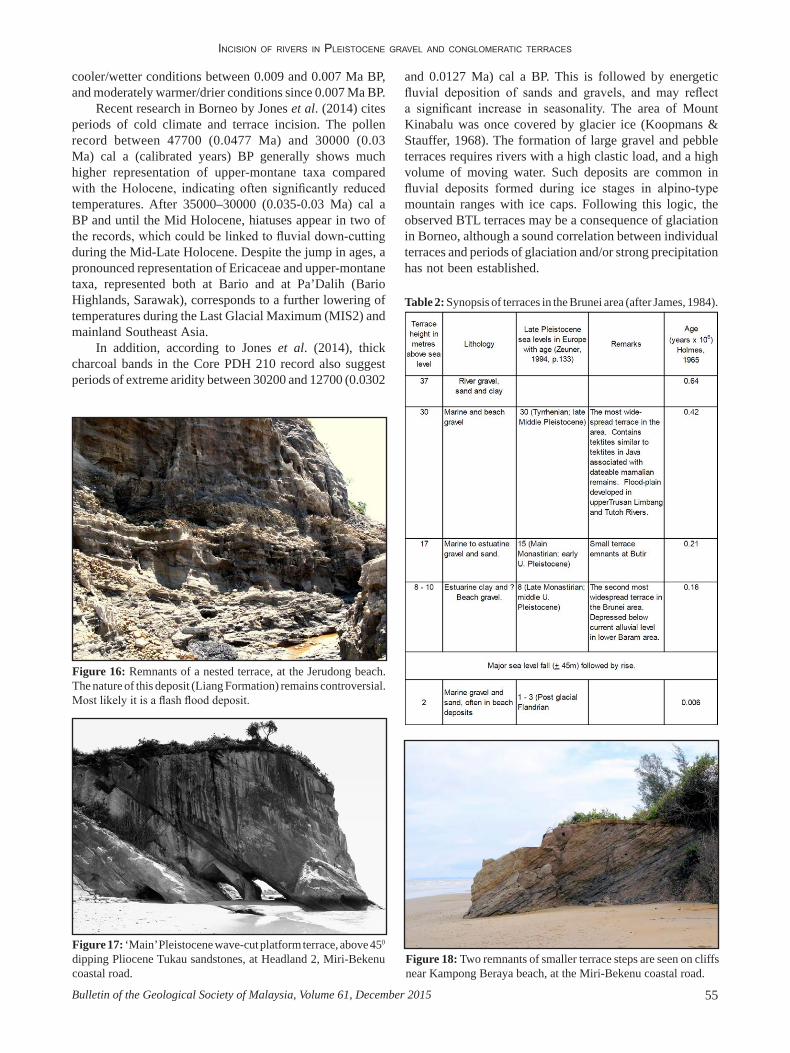
These appear to be low-uplift terraces in Penck’s terminology. A very good summary is provided by James (1984) describing the terraces, as well as uplift and incision with reference made to Wilford (1961) and Holmes (1965). A river gravel, sand and clay terrace with the highest incision measured at 37 m, is age-dated as 0.64 Ma BP. Marine gravel and beach deposits formed at 0.42 Ma BP, 0.21 Ma BP, 0.16 Ma BP and 0.006 Ma BP (Tables 2 and 3). Figure 16 shows remnants of a nested Meligan terrace (Liang Formation) near to the Jerudong Park Beach.
MiriCoastal deposits in the Miri area were studied and age-
dated by Kessler & Jong (2011, 2014). In addition to the
Figure14: Limbang River terrace near Nanga Medremit. Components look very similar compared to the discussed Baram terrace, but appear to be a little smaller, apart from the loess bed, which incises Setup shale.
Figure 15: Map with terrace deposits, Temburong River with elevations (after Sandal, 1996).
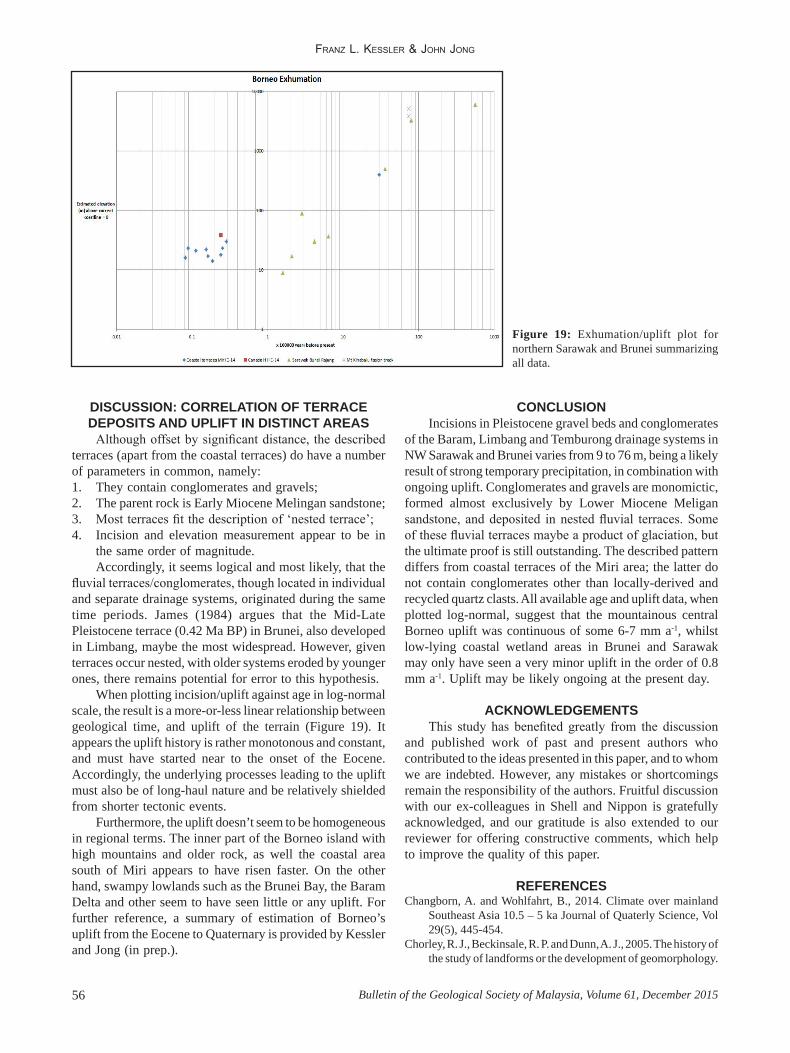
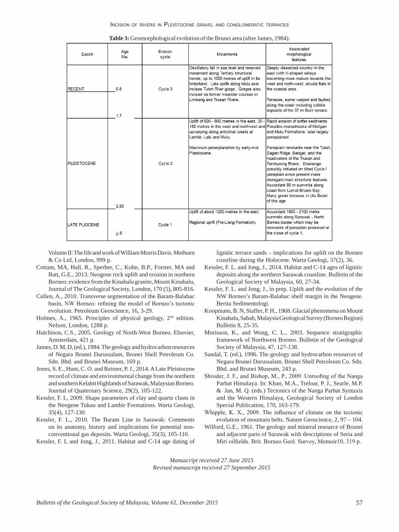
main wave-cut platform and terrace elevated some 20-25 m above MSL (Figure 17), there are at least remnants of two minor terraces seen near the Kampong Beraya (Figure 18). These smaller ‘stepping’ terraces suggest that, being much younger than the Late Pleistocene terrace, uplift of the Borneo Island may still be ongoing.
Other than the examples described above, we do not see any Melingan conglomerates, but instead only milky quartzes (Kessler & Jong, 2011, 2014); these may stem from quartz dykes within the Rajang metamorphic sequences, recycled later through the Neogene Tukau and Lambir Formations (Kessler, 2009).
TERRACES AND RECENT CLIMATE RECORDS Generating the climate records of Borneo island are
challenging, given most if not all of the data depend on a good preservation of relevant deposits (terraces, etc.).
In mainland Southeast Asia, Chabangborn & Wohlfahrt (2014) point to strong climatic swings from the Late Pleistocene (Tarrantian) until the Present, and climate changed several times from wet/cool to dry/hot, and back. Their results indicate temperatures and precipitation in mainland Southeast Asia generally exceeded 18 °C and 1100 mm a-1 during the Holocene. The mainland experienced cool/wet climatic conditions between 0.015 and 0.01 Ma BP, a warmer/drier climate between 0.01 and 0.009 Ma BP,
IncIsIon of rIvers In PleIstocene gravel and conglomeratIc terraces
55Bulletin of the Geological Society of Malaysia, Volume 61, December 2015
cooler/wetter conditions between 0.009 and 0.007 Ma BP, and moderately warmer/drier conditions since 0.007 Ma BP.
Recent research in Borneo by Jones et al. (2014) cites periods of cold climate and terrace incision. The pollen record between 47700 (0.0477 Ma) and 30000 (0.03 Ma) cal a (calibrated years) BP generally shows much higher representation of upper-montane taxa compared with the Holocene, indicating often significantly reduced temperatures. After 35000–30000 (0.035-0.03 Ma) cal a BP and until the Mid Holocene, hiatuses appear in two of the records, which could be linked to fluvial down-cutting during the Mid-Late Holocene. Despite the jump in ages, a pronounced representation of Ericaceae and upper-montane taxa, represented both at Bario and at Pa’Dalih (Bario Highlands, Sarawak), corresponds to a further lowering of temperatures during the Last Glacial Maximum (MIS2) and mainland Southeast Asia.
In addition, according to Jones et al. (2014), thick charcoal bands in the Core PDH 210 record also suggest periods of extreme aridity between 30200 and 12700 (0.0302
Figure 16: Remnants of a nested terrace, at the Jerudong beach. The nature of this deposit (Liang Formation) remains controversial. Most likely it is a flash flood deposit.
Figure 17: ‘Main’ Pleistocene wave-cut platform terrace, above 450 dipping Pliocene Tukau sandstones, at Headland 2, Miri-Bekenu coastal road.
Figure 18: Two remnants of smaller terrace steps are seen on cliffs near Kampong Beraya beach, at the Miri-Bekenu coastal road.
and 0.0127 Ma) cal a BP. This is followed by energetic fluvial deposition of sands and gravels, and may reflect a significant increase in seasonality. The area of Mount Kinabalu was once covered by glacier ice (Koopmans & Stauffer, 1968). The formation of large gravel and pebble terraces requires rivers with a high clastic load, and a high volume of moving water. Such deposits are common in fluvial deposits formed during ice stages in alpino-type mountain ranges with ice caps. Following this logic, the observed BTL terraces may be a consequence of glaciation in Borneo, although a sound correlation between individual terraces and periods of glaciation and/or strong precipitation has not been established.
Table 2: Synopsis of terraces in the Brunei area (after James, 1984).
Franz L. KessLer & John Jong
Bulletin of the Geological Society of Malaysia, Volume 61, December 201556
DISCUSSION: CORRELATION OF TERRACE DEPOSITS AND UPLIFT IN DISTINCT AREAS
Although offset by significant distance, the described terraces (apart from the coastal terraces) do have a number of parameters in common, namely:1. They contain conglomerates and gravels;2. The parent rock is Early Miocene Melingan sandstone;3. Most terraces fit the description of ‘nested terrace’;4. Incision and elevation measurement appear to be in
the same order of magnitude. Accordingly, it seems logical and most likely, that the
fluvial terraces/conglomerates, though located in individual and separate drainage systems, originated during the same time periods. James (1984) argues that the Mid-Late Pleistocene terrace (0.42 Ma BP) in Brunei, also developed in Limbang, maybe the most widespread. However, given terraces occur nested, with older systems eroded by younger ones, there remains potential for error to this hypothesis.
When plotting incision/uplift against age in log-normal scale, the result is a more-or-less linear relationship between geological time, and uplift of the terrain (Figure 19). It appears the uplift history is rather monotonous and constant, and must have started near to the onset of the Eocene. Accordingly, the underlying processes leading to the uplift must also be of long-haul nature and be relatively shielded from shorter tectonic events.
Furthermore, the uplift doesn’t seem to be homogeneous in regional terms. The inner part of the Borneo island with high mountains and older rock, as well the coastal area south of Miri appears to have risen faster. On the other hand, swampy lowlands such as the Brunei Bay, the Baram Delta and other seem to have seen little or any uplift. For further reference, a summary of estimation of Borneo’s uplift from the Eocene to Quaternary is provided by Kessler and Jong (in prep.).
CONCLUSIONIncisions in Pleistocene gravel beds and conglomerates
of the Baram, Limbang and Temburong drainage systems in NW Sarawak and Brunei varies from 9 to 76 m, being a likely result of strong temporary precipitation, in combination with ongoing uplift. Conglomerates and gravels are monomictic, formed almost exclusively by Lower Miocene Meligan sandstone, and deposited in nested fluvial terraces. Some of these fluvial terraces maybe a product of glaciation, but the ultimate proof is still outstanding. The described pattern differs from coastal terraces of the Miri area; the latter do not contain conglomerates other than locally-derived and recycled quartz clasts. All available age and uplift data, when plotted log-normal, suggest that the mountainous central Borneo uplift was continuous of some 6-7 mm a-1, whilst low-lying coastal wetland areas in Brunei and Sarawak may only have seen a very minor uplift in the order of 0.8 mm a-1. Uplift may be likely ongoing at the present day.
ACKNOWLEDGEMENTSThis study has benefited greatly from the discussion
and published work of past and present authors who contributed to the ideas presented in this paper, and to whom we are indebted. However, any mistakes or shortcomings remain the responsibility of the authors. Fruitful discussion with our ex-colleagues in Shell and Nippon is gratefully acknowledged, and our gratitude is also extended to our reviewer for offering constructive comments, which help to improve the quality of this paper.
REFERENCESChangborn, A. and Wohlfahrt, B., 2014. Climate over mainland
Southeast Asia 10.5 – 5 ka Journal of Quaterly Science, Vol 29(5), 445-454.
Chorley, R. J., Beckinsale, R. P. and Dunn, A. J., 2005. The history of the study of landforms or the development of geomorphology.
Figure 19: Exhumation/uplift plot for northern Sarawak and Brunei summarizing all data.
IncIsIon of rIvers In PleIstocene gravel and conglomeratIc terraces
57Bulletin of the Geological Society of Malaysia, Volume 61, December 2015
Table 3: Geomorphological evolution of the Brunei area (after James, 1984).
Volume II: The life and work of William Morris Davis. Methuen & Co Ltd, London, 999 p.
Cottam, MA, Hall, R., Sperber, C., Kohn, B.P., Forster, MA and Batt, G.E., 2013. Neogene rock uplift and erosion in northern Borneo: evidence from the Kinabalu granite, Mount Kinabalu, Journal of The Geological Society, London, 170 (5), 805-816.
Cullen, A., 2010. Transverse segmentation of the Baram-Balabac basin, NW Borneo: refining the model of Borneo’s tectonic evolution. Petroleum Geoscience, 16, 3-29.
Holmes, A., 1965. Principles of physical geology, 2nd edition. Nelson, London, 1288 p.
Hutchison, C.S., 2005. Geology of North-West Borneo. Elsevier, Amsterdam, 421 p.
James, D. M. D, (ed.), 1984. The geology and hydrocarbon resources of Negara Brunei Darussalam, Brunei Shell Petroleum Co. Sdn. Bhd. and Brunei Museum, 169 p.
Jones, S. E., Hunt, C. O. and Reimer, P. J., 2014. A Late Pleistocene record of climate and environmental change from the northern and southern Kelabit Highlands of Sarawak, Malaysian Borneo. Journal of Quaternary Science, 29(2), 105-122.
Kessler, F. L, 2009. Shape parameters of clay and quartz clasts in the Neogene Tukau and Lambir Formations. Warta Geologi, 35(4), 127-130.
Kessler, F. L., 2010. The Baram Line in Sarawak: Comments on its anatomy, history and implications for potential non-conventional gas deposits. Warta Geologi, 35(3), 105-110.
Kessler, F. L and Jong, J., 2011. Habitat and C-14 age dating of
lignitic terrace sands – implications for uplift on the Borneo coastline during the Holocene. Warta Geologi, 37(2), 36.
Kessler, F. L. and Jong, J., 2014. Habitat and C-14 ages of lignitic deposits along the northern Sarawak coastline. Bulletin of the Geological Society of Malaysia, 60, 27-34.
Kessler, F. L. and Jong, J., in prep. Uplift and the evolution of the NW Borneo’s Baram-Balabac shelf margin in the Neogene. Berita Sedimentologi.
Koopmans, B. N, Staffer, P. H., 1968. Glacial phenomena on Mount Kinabalu, Sabah, Malaysia Geological Survey (Borneo Region) Bulletin 8, 25-35.
Morisson, K., and Wong, C. L., 2003. Sequence stratigraphic framework of Northwest Borneo. Bulletin of the Geological Society of Malaysia, 47, 127-138.
Sandal, T. (ed.), 1996. The geology and hydrocarbon resources of Negara Brunei Darussalam. Brunei Shell Petroleum Co. Sdn. Bhd. and Brunei Museum, 243 p.
Shroder, J. F., and Bishop, M., P., 2009. Unroofing of the Nanga Parbat Himalaya. In: Khan, M.A., Treloar, P. J., Searle, M.P. & Jan, M. Q. (eds.) Tectonics of the Nanga Parbat Syntaxis and the Western Himalaya, Geological Society of London Special Publication, 170, 163-179.
Whipple, K. X., 2009. The influence of climate on the tectonic evolution of mountain belts. Nature Geoscience, 2, 97 – 104.
Wilford, G.E., 1961. The geology and mineral resource of Brunei and adjacent parts of Sarawak with descriptions of Seria and Miri oilfields. Brit. Borneo Geol. Survey, Memoir10, 319 p.
Manuscript received 27 June 2015Revised manuscript received 27 September 2015