hydrocarbon columns of oil and gas fields in the …
TRANSCRIPT
Berita Sedimentologi [Pick the date]
Number 46 – November 2020 Page 51 of 74
HYDROCARBON COLUMNS OF OIL AND GAS FIELDS IN THE
SOUTH SUMATRA BASIN
Veridaus Napitupulu1, Miftahul Jannah1, Michael Silaen1, Herman Darman1,2
1 Indogeo Social Enterprise, Indonesia 2 Currently with Petronas Carigali, Kuala Lumpur, Malaysia
*Correspondence author: [email protected]
INTRODUCTION
The South Sumatra Basin is a prolific basin with a long history of oil and gas exploration that started
in early 1900s. It is located in the southern part of
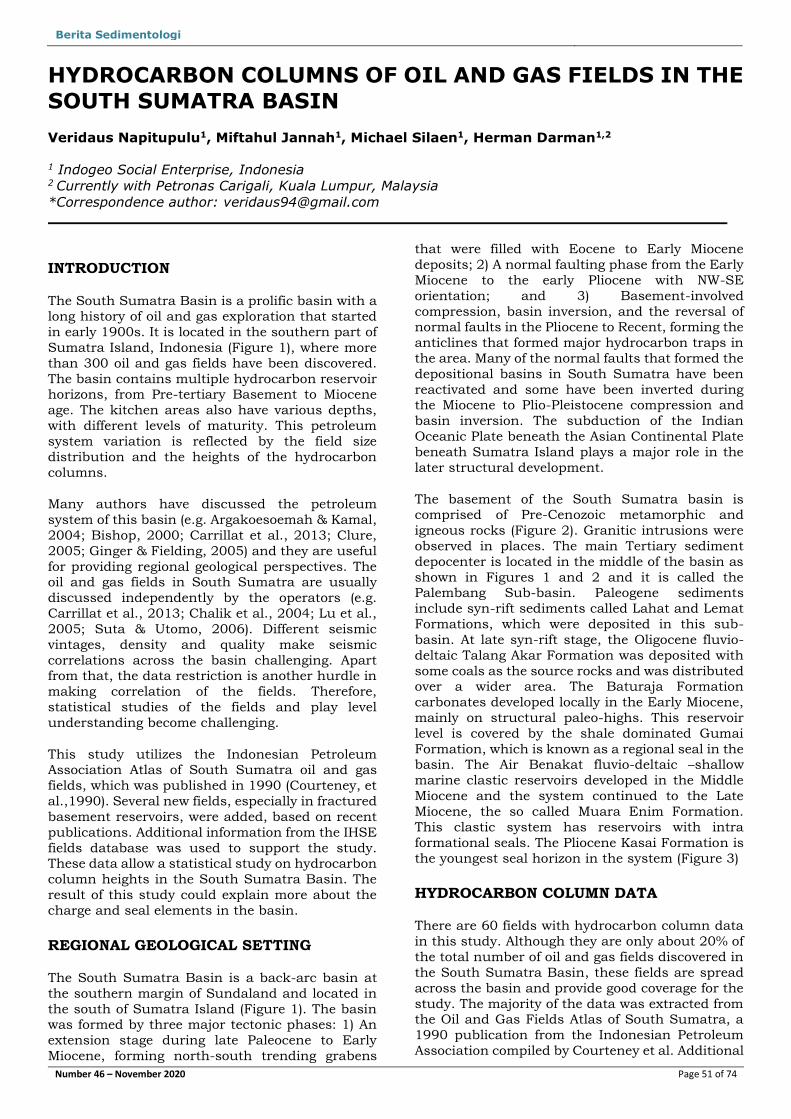
Sumatra Island, Indonesia (Figure 1), where more
than 300 oil and gas fields have been discovered.
The basin contains multiple hydrocarbon reservoir horizons, from Pre-tertiary Basement to Miocene
age. The kitchen areas also have various depths,
with different levels of maturity. This petroleum
system variation is reflected by the field size
distribution and the heights of the hydrocarbon
columns.
Many authors have discussed the petroleum
system of this basin (e.g. Argakoesoemah & Kamal,
2004; Bishop, 2000; Carrillat et al., 2013; Clure,
2005; Ginger & Fielding, 2005) and they are useful
for providing regional geological perspectives. The oil and gas fields in South Sumatra are usually
discussed independently by the operators (e.g.
Carrillat et al., 2013; Chalik et al., 2004; Lu et al.,
2005; Suta & Utomo, 2006). Different seismic
vintages, density and quality make seismic
correlations across the basin challenging. Apart from that, the data restriction is another hurdle in
making correlation of the fields. Therefore,
statistical studies of the fields and play level
understanding become challenging.
This study utilizes the Indonesian Petroleum Association Atlas of South Sumatra oil and gas
fields, which was published in 1990 (Courteney, et
al.,1990). Several new fields, especially in fractured
basement reservoirs, were added, based on recent
publications. Additional information from the IHSE
fields database was used to support the study. These data allow a statistical study on hydrocarbon
column heights in the South Sumatra Basin. The
result of this study could explain more about the
charge and seal elements in the basin.
REGIONAL GEOLOGICAL SETTING
The South Sumatra Basin is a back-arc basin at
the southern margin of Sundaland and located in
the south of Sumatra Island (Figure 1). The basin was formed by three major tectonic phases: 1) An
extension stage during late Paleocene to Early
Miocene, forming north-south trending grabens
that were filled with Eocene to Early Miocene
deposits; 2) A normal faulting phase from the Early
Miocene to the early Pliocene with NW-SE
orientation; and 3) Basement-involved
compression, basin inversion, and the reversal of normal faults in the Pliocene to Recent, forming the
anticlines that formed major hydrocarbon traps in
the area. Many of the normal faults that formed the
depositional basins in South Sumatra have been
reactivated and some have been inverted during the Miocene to Plio-Pleistocene compression and
basin inversion. The subduction of the Indian
Oceanic Plate beneath the Asian Continental Plate
beneath Sumatra Island plays a major role in the
later structural development.
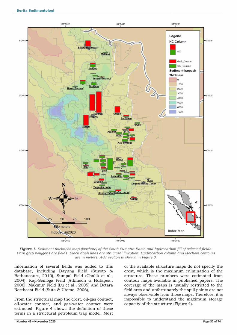
The basement of the South Sumatra basin is comprised of Pre-Cenozoic metamorphic and
igneous rocks (Figure 2). Granitic intrusions were
observed in places. The main Tertiary sediment
depocenter is located in the middle of the basin as
shown in Figures 1 and 2 and it is called the Palembang Sub-basin. Paleogene sediments
include syn-rift sediments called Lahat and Lemat
Formations, which were deposited in this sub-
basin. At late syn-rift stage, the Oligocene fluvio-
deltaic Talang Akar Formation was deposited with
some coals as the source rocks and was distributed over a wider area. The Baturaja Formation
carbonates developed locally in the Early Miocene,
mainly on structural paleo-highs. This reservoir
level is covered by the shale dominated Gumai
Formation, which is known as a regional seal in the basin. The Air Benakat fluvio-deltaic –shallow
marine clastic reservoirs developed in the Middle
Miocene and the system continued to the Late
Miocene, the so called Muara Enim Formation.
This clastic system has reservoirs with intra
formational seals. The Pliocene Kasai Formation is
the youngest seal horizon in the system (Figure 3)
HYDROCARBON COLUMN DATA
There are 60 fields with hydrocarbon column data
in this study. Although they are only about 20% of
the total number of oil and gas fields discovered in
the South Sumatra Basin, these fields are spread
across the basin and provide good coverage for the
study. The majority of the data was extracted from the Oil and Gas Fields Atlas of South Sumatra, a
1990 publication from the Indonesian Petroleum
Association compiled by Courteney et al. Additional
Berita Sedimentologi [Pick the date]
Number 46 – November 2020 Page 52 of 74
information of several fields was added to this
database, including Dayung Field (Suyoto &
Bethancourt, 2010), Sumpal Field (Chalik et al.,
2004), Kaji-Semoga Field (Atkinson & Hutapea.,
2006), Makmur Field (Lu et al., 2005) and Betara
Northeast Field (Suta & Utomo, 2006),
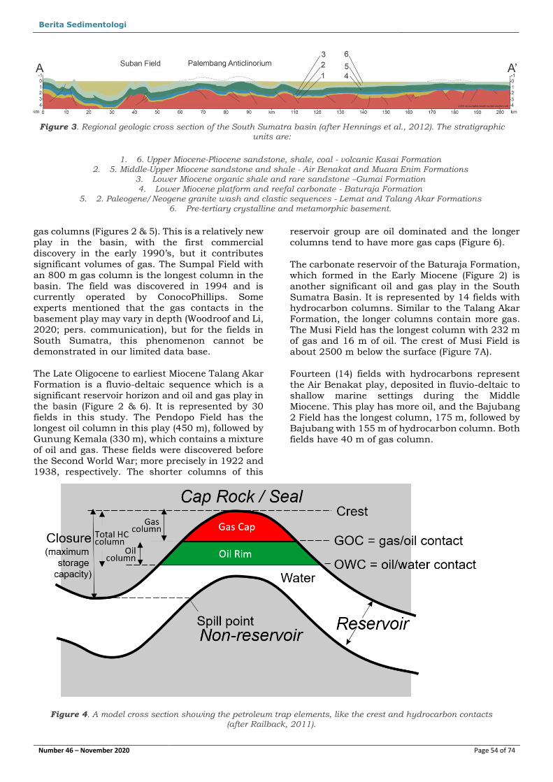
From the structural map the crest, oil-gas contact,
oil-water contact, and gas-water contact were
extracted. Figure 4 shows the definition of these
terms in a structural petroleum trap model. Most
of the available structure maps do not specify the
crest, which is the maximum culmination of the
structure. These numbers were estimated from
contour maps available in published papers. The
coverage of the maps is usually restricted to the
field area and unfortunately the spill points are not always observable from those maps. Therefore, it is
impossible to understand the maximum storage
capacity of the structure (Figure 4).
Figure 1. Sediment thickness map (Isochore) of the South Sumatra Basin and hydrocarbon fill of selected fields. Dark grey polygons are fields. Black dash lines are structural lineation. Hydrocarbon column and isochore contours
are in meters. A-A’ section is shown in Figure 3.
Berita Sedimentologi [Pick the date]
Number 46 – November 2020 Page 53 of 74
The height of a hydrocarbon column is important
information, as it reflects the charge and seal elements of the petroleum system. The oil and gas
charge depends on the source rock type, quantity,
maturity, timing and migration factors. For the seal
element, the column height also depends on the
sealing capacity of the cap rock. In general, a long hydrocarbon column indicates a strong top seal
and effective charge capacity. Shorter columns may
indicate possible leakage through the seal and/or
a limited hydrocarbon charge to the trap. If spill
points are known, it will tell more about the charge
capacity. Hydrocarbon columns that extend from
the crest to the spill point, also known as full to spill, indicate a strong charge from the kitchen and
maximum holding capacity of the cap rock.
HYDROCARBON COLUMNS PER PLAY LEVEL
The oldest reservoir in the South Sumatra Basin is
the fractured Pre-tertiary basement. There are 4
fields included in this study and they contain long
Figure 2. Stratigraphy of South Sumatra basin (after Ginger & Fielding, 2005) with hydrocarbon occurrences indicated as bubbles. Red bubbles indicate gas, and green bubbles indicate oil occurrences. Bubble sizes reflect the
relative sized of oil and gas discoveries.
Berita Sedimentologi [Pick the date]
Number 46 – November 2020 Page 54 of 74
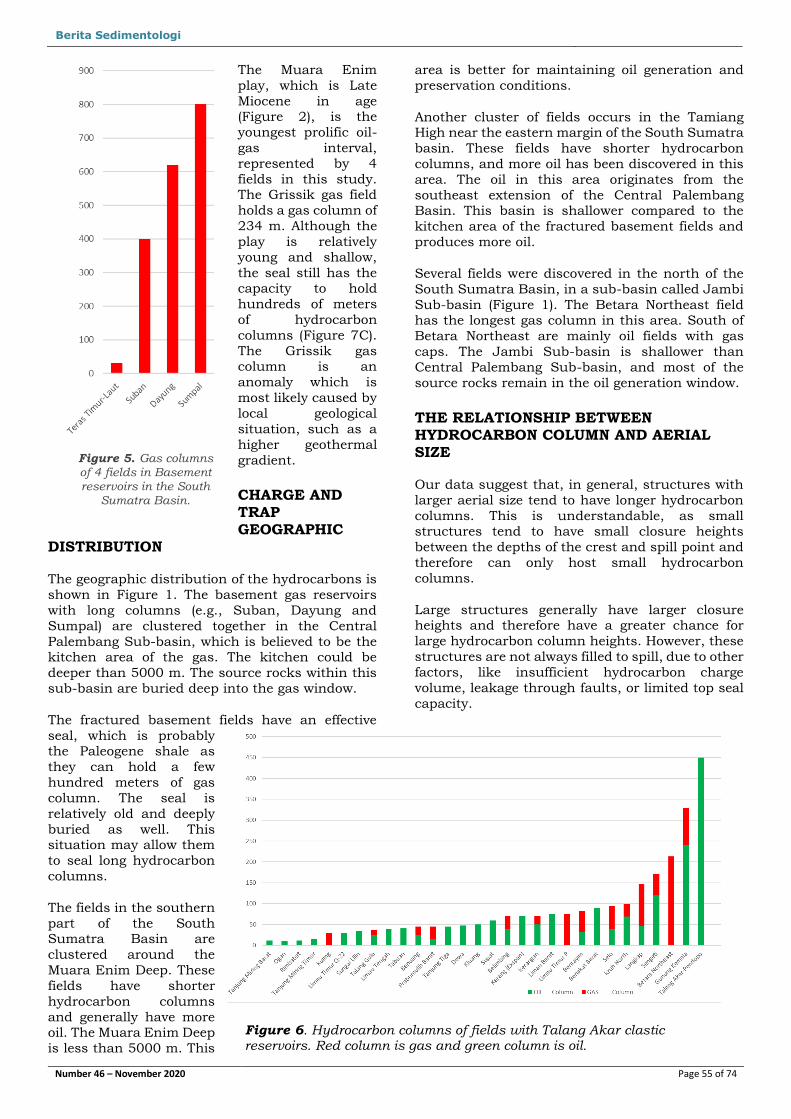
gas columns (Figures 2 & 5). This is a relatively new
play in the basin, with the first commercial
discovery in the early 1990’s, but it contributes
significant volumes of gas. The Sumpal Field with
an 800 m gas column is the longest column in the
basin. The field was discovered in 1994 and is currently operated by ConocoPhillips. Some
experts mentioned that the gas contacts in the
basement play may vary in depth (Woodroof and Li,
2020; pers. communication), but for the fields in
South Sumatra, this phenomenon cannot be
demonstrated in our limited data base.
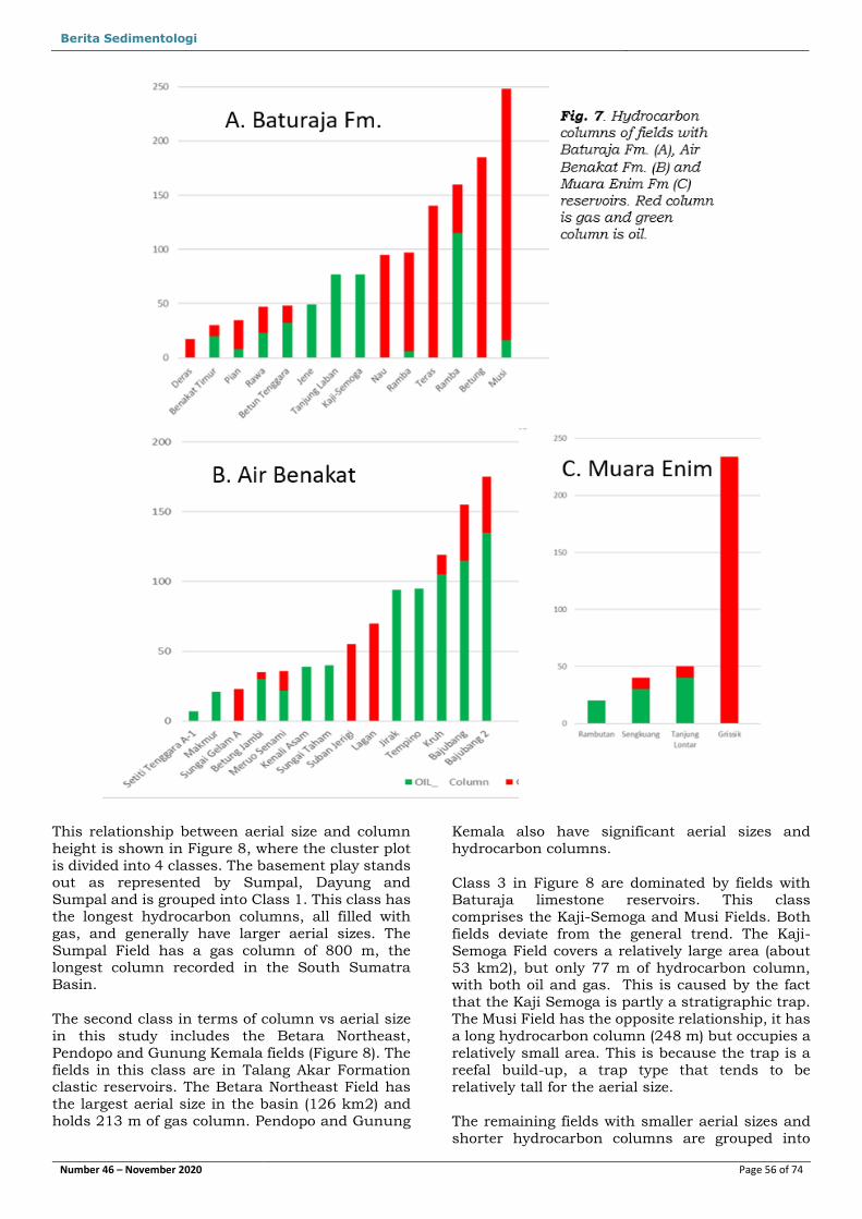
The Late Oligocene to earliest Miocene Talang Akar
Formation is a fluvio-deltaic sequence which is a
significant reservoir horizon and oil and gas play in
the basin (Figure 2 & 6). It is represented by 30
fields in this study. The Pendopo Field has the longest oil column in this play (450 m), followed by
Gunung Kemala (330 m), which contains a mixture
of oil and gas. These fields were discovered before
the Second World War; more precisely in 1922 and
1938, respectively. The shorter columns of this
reservoir group are oil dominated and the longer
columns tend to have more gas caps (Figure 6).
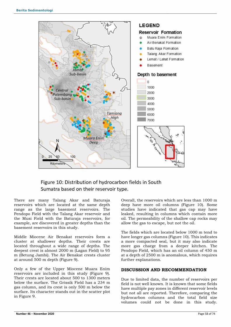
The carbonate reservoir of the Baturaja Formation,
which formed in the Early Miocene (Figure 2) is
another significant oil and gas play in the South
Sumatra Basin. It is represented by 14 fields with hydrocarbon columns. Similar to the Talang Akar
Formation, the longer columns contain more gas.
The Musi Field has the longest column with 232 m
of gas and 16 m of oil. The crest of Musi Field is
about 2500 m below the surface (Figure 7A).
Fourteen (14) fields with hydrocarbons represent
the Air Benakat play, deposited in fluvio-deltaic to
shallow marine settings during the Middle
Miocene. This play has more oil, and the Bajubang
2 Field has the longest column, 175 m, followed by
Bajubang with 155 m of hydrocarbon column. Both
fields have 40 m of gas column.
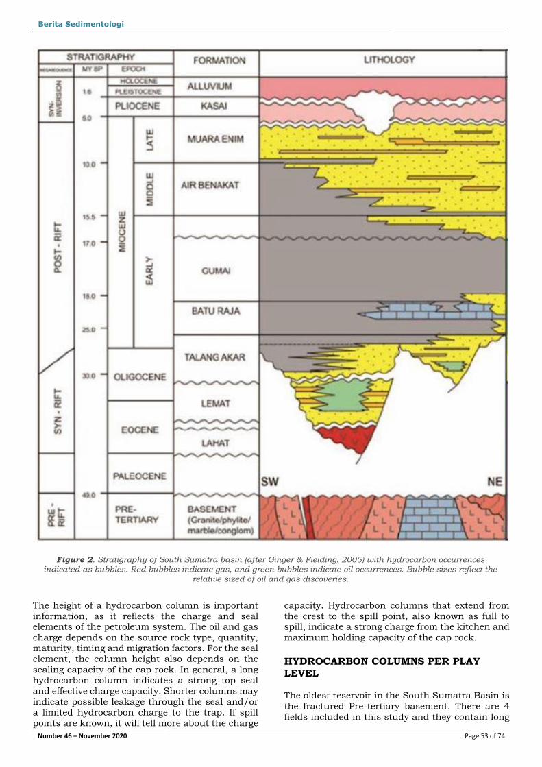
Figure 3. Regional geologic cross section of the South Sumatra basin (after Hennings et al., 2012). The stratigraphic units are:
1. 6. Upper Miocene-Pliocene sandstone, shale, coal - volcanic Kasai Formation 2. 5. Middle-Upper Miocene sandstone and shale - Air Benakat and Muara Enim Formations
3. Lower Miocene organic shale and rare sandstone –Gumai Formation 4. Lower Miocene platform and reefal carbonate - Baturaja Formation
5. 2. Paleogene/Neogene granite wash and clastic sequences - Lemat and Talang Akar Formations 6. Pre-tertiary crystalline and metamorphic basement.
Figure 4. A model cross section showing the petroleum trap elements, like the crest and hydrocarbon contacts (after Railback, 2011).
Berita Sedimentologi [Pick the date]
Number 46 – November 2020 Page 55 of 74
The Muara Enim
play, which is Late
Miocene in age (Figure 2), is the
youngest prolific oil-
gas interval,
represented by 4
fields in this study. The Grissik gas field
holds a gas column of
234 m. Although the
play is relatively
young and shallow,
the seal still has the capacity to hold
hundreds of meters
of hydrocarbon
columns (Figure 7C).
The Grissik gas column is an
anomaly which is
most likely caused by
local geological
situation, such as a
higher geothermal
gradient.
CHARGE AND TRAP
GEOGRAPHIC DISTRIBUTION
The geographic distribution of the hydrocarbons is
shown in Figure 1. The basement gas reservoirs
with long columns (e.g., Suban, Dayung and
Sumpal) are clustered together in the Central
Palembang Sub-basin, which is believed to be the kitchen area of the gas. The kitchen could be
deeper than 5000 m. The source rocks within this
sub-basin are buried deep into the gas window.
The fractured basement fields have an effective
seal, which is probably the Paleogene shale as
they can hold a few
hundred meters of gas
column. The seal is
relatively old and deeply
buried as well. This situation may allow them
to seal long hydrocarbon
columns.
The fields in the southern
part of the South Sumatra Basin are
clustered around the
Muara Enim Deep. These
fields have shorter
hydrocarbon columns
and generally have more oil. The Muara Enim Deep
is less than 5000 m. This
area is better for maintaining oil generation and
preservation conditions.
Another cluster of fields occurs in the Tamiang High near the eastern margin of the South Sumatra
basin. These fields have shorter hydrocarbon
columns, and more oil has been discovered in this
area. The oil in this area originates from the
southeast extension of the Central Palembang Basin. This basin is shallower compared to the
kitchen area of the fractured basement fields and
produces more oil.
Several fields were discovered in the north of the
South Sumatra Basin, in a sub-basin called Jambi
Sub-basin (Figure 1). The Betara Northeast field has the longest gas column in this area. South of
Betara Northeast are mainly oil fields with gas
caps. The Jambi Sub-basin is shallower than
Central Palembang Sub-basin, and most of the
source rocks remain in the oil generation window.
THE RELATIONSHIP BETWEEN HYDROCARBON COLUMN AND AERIAL SIZE
Our data suggest that, in general, structures with
larger aerial size tend to have longer hydrocarbon
columns. This is understandable, as small structures tend to have small closure heights
between the depths of the crest and spill point and
therefore can only host small hydrocarbon
columns.
Large structures generally have larger closure heights and therefore have a greater chance for
large hydrocarbon column heights. However, these
structures are not always filled to spill, due to other
factors, like insufficient hydrocarbon charge
volume, leakage through faults, or limited top seal
capacity.
Figure 5. Gas columns of 4 fields in Basement reservoirs in the South
Sumatra Basin.
Figure 6. Hydrocarbon columns of fields with Talang Akar clastic reservoirs. Red column is gas and green column is oil.
Berita Sedimentologi [Pick the date]
Number 46 – November 2020 Page 56 of 74
This relationship between aerial size and column
height is shown in Figure 8, where the cluster plot
is divided into 4 classes. The basement play stands out as represented by Sumpal, Dayung and
Sumpal and is grouped into Class 1. This class has
the longest hydrocarbon columns, all filled with
gas, and generally have larger aerial sizes. The
Sumpal Field has a gas column of 800 m, the longest column recorded in the South Sumatra
Basin.
The second class in terms of column vs aerial size
in this study includes the Betara Northeast,
Pendopo and Gunung Kemala fields (Figure 8). The
fields in this class are in Talang Akar Formation clastic reservoirs. The Betara Northeast Field has
the largest aerial size in the basin (126 km2) and
holds 213 m of gas column. Pendopo and Gunung
Kemala also have significant aerial sizes and
hydrocarbon columns.
Class 3 in Figure 8 are dominated by fields with Baturaja limestone reservoirs. This class
comprises the Kaji-Semoga and Musi Fields. Both
fields deviate from the general trend. The Kaji-
Semoga Field covers a relatively large area (about
53 km2), but only 77 m of hydrocarbon column, with both oil and gas. This is caused by the fact
that the Kaji Semoga is partly a stratigraphic trap.
The Musi Field has the opposite relationship, it has
a long hydrocarbon column (248 m) but occupies a
relatively small area. This is because the trap is a
reefal build-up, a trap type that tends to be
relatively tall for the aerial size.
The remaining fields with smaller aerial sizes and
shorter hydrocarbon columns are grouped into

Berita Sedimentologi [Pick the date]
Number 46 – November 2020 Page 57 of 74
Class 4 (Figure 8). These fields have less than 200
m of hydrocarbon columns and have an aerial size
of less than 40 km2.
THE RELATIONSHIP BETWEEN HYDROCARBON COLUMN AND CREST DEPTH
The data collected in this study suggest a poor correlation between depth of burial and
hydrocarbon column heights. Basement reservoirs
are the oldest reservoirs in age, but they are not the
deepest in the basin. The basement reservoirs observed in this study (Figure 9) range from 1250
m deep (Dayung Field) to 2100 m (Suban Field).
The reservoirs which are comprised a mixture of
igneous and metamorphic rocks contain gas
columns up to 800 m (Sumpal Field). However,
Teras Timur Laut has only 30 m of gas column.
Figure 8. Scatter plot of HC Column Height vs Field Aerial Size.
Figure 9. Scatter plot of HC Column Height vs Crest depth
Berita Sedimentologi [Pick the date]
Number 46 – November 2020 Page 58 of 74
There are many Talang Akar and Baturaja
reservoirs which are located at the same depth
range as the large basement reservoirs. The Pendopo Field with the Talang Akar reservoir and
the Musi Field with the Baturaja reservoirs, for
example, are discovered in greater depths than the
basement reservoirs in this study.
Middle Miocene Air Benakat reservoirs form a cluster at shallower depths. Their crests are
located throughout a wide range of depths. The
deepest crest is almost 2000 m (Lagan Field) to 95
m (Betung Jambi). The Air Benakat crests cluster
at around 500 m depth (Figure 9).
Only a few of the Upper Miocene Muara Enim reservoirs are included in this study (Figure 9).
Their crests are located about 500 to 1300 meters
below the surface. The Grissik Field has a 234 m
gas column, and its crest is only 500 m below the
surface. Its character stands out in the scatter plot
in Figure 9.
Overall, the reservoirs which are less than 1000 m
deep have more oil columns (Figure 10). Some
studies have indicated that gas cap may have leaked, resulting in columns which contain more
oil. The permeability of the shallow cap rocks may
allow the gas to escape, but not the oil.
The fields which are located below 1000 m tend to
have longer gas columns (Figure 10). This indicates a more compacted seal, but it may also indicate
more gas charge from a deeper kitchen. The
Pendopo Field, which has an oil column of 450 m
at a depth of 2500 m is anomalous, which requires
further explanations.
DISCUSSION AND RECOMMENDATION
Due to limited data, the number of reservoirs per
field is not well known. It is known that some fields have multiple pay zones in different reservoir levels
but not all are reported. Therefore, comparing the
hydrocarbon columns and the total field size
volumes could not be done in this study.
Berita Sedimentologi [Pick the date]
Number 46 – November 2020 Page 59 of 74
Comprehensive field studies and reports are
required to make this comparison.
As kitchen data is usually difficult to obtain due to
great depths, hydrocarbon columns are a good
source of information about the kitchen. In this
study, it is seen that deep kitchens supply more gas, whilst shallower kitchens supply more oil to
the nearby fields. Basin modelling studies are
needed to support this observation.
To improve the understanding of kitchens and
hydrocarbon field columns, more data is required
for the study. Ideally, it should be coupled with regional seismic interpretations and detailed field
studies. There is more data available after the IPA
Field Atlas (Courteney et al., 1990) was published,
which should be included in this study. It is
recommended that the government release more data for studies, which certainly will improve the
understanding of present observations and
hopefully lead to new discoveries.
CONCLUSION
This hydrocarbon column study, with limited data
availability, suggests some
general trends. Local
factors, like variations in
hydrocarbon charge and leakage, can cause
deviations from the general
patterns.
The basement play can
hold much longer gas
columns than younger plays. The distribution of
these fields is also very
localized, which is
somewhere close to the
Palembang Deep Sub-
basin.
Fields in shallower basins
are more likely to be
charged with oil, as shown
by the fields around the
Jambi Sub-basin and Muara Enim Deep. The oil columns in the South
Sumatra basin are generally shorter compared to
the gas columns.
In general, the younger and shallower reservoirs
will most likely have cap rocks with a lower sealing capacity. Therefore, the younger and shallower
plays have shorter columns compared to the
basement play. In certain conditions, there are
anomalies due to the local geological conditions.
Hopefully, this study can stimulate more detailed
studies, with more data and incorporating additional parameters that may affect hydrocarbon
column heights, and also determine possible
differences in column heights between gas-
dominated versus oil-dominated accumulations.
REFERENCES
Argakoesoemah, R.M.I. and Kamal, A., 2004. Ancient Talang Akar deep-water sediments in
South Sumatra Basin: a new exploration play.
In: R.A. Noble et al. (eds.) Proc. Int. Conf.
Deepwater and frontier exploration in Asia &
Australasia, Jakarta, Indonesian Petroleum
Assoc., p. 251-267.
Argakoesoemah, R.M.I., Raharja, M., Winardhi, S.,
Tarigan, R., Maksum, T.F., and Aimar, A., 2005.
Telisa shallow marine sandstone as an emerging exploration target in Palembang High, South
Sumatra Basin. Proc. 30th Ann. Conv.
Indonesian Petroleum Assoc., 1, p. 101-120.
Atkinson, C., Renolds, M., and Hutapea, O., 2006.
Stratigraphic traps in the Tertiary rift basins of Indonesia: case studies and future potential. In
Allen, M.R., Goffey, G.P., Morgan, R.K. and
Walker, I.M. eds., The deliberate search for the
stratigraphic trap, Geological Society, London,
Special Publ. 254, p. 105-126.
Figure 11. Vertical distribution of oil and gas in South Sumatra Basin, based on the 60 fields in this study.
Berita Sedimentologi [Pick the date]
Number 46 – November 2020 Page 60 of 74
Bishop, M. G., 2000. South Sumatra Basin
Province, Indonesia: The Lahat / Talang Akar –
Cenozoic Total Petroleum System. USGS Open
File Report 99-50S, p. 1-22.
Carrillat, A., Bora, D., Dubois, A., Kusdiantoro, F.,
Yudho, S., Wibowo, E., Mustri, M., Tobing, J. C.,
Gomez, P., Xue, F., Balasejus, D., McDonald,
T.D. and Audemand, P., 2013.In: Integrated Regional Interpretation and New Insight on
Petroleum System of South Sumatra Basin,
Indonesia. SPE Asia Pacific Oil and Gas
Conference and Exhibition, 22-24 October,
Jakarta, SPE 165848, p. 1-8.
Chalik, M., Pujasmadi, B., Fauzi, M., and Bazed, M., 2004. Sumpal Field, South Sumatra - case
history of the delineation and production of a
fractured basement reservoir. In: R.A. Noble et
al. (eds.) Proc. Int. Conf. Deepwater and frontier
exploration in Asia & Australasia, Jakarta,
Indonesian Petroleum Assoc., p. 199-224.
Courteney, S., Cockroft, P., Lorentz, R., Miller, R.,
Ott, H. L, Prijosoesilo, P., Suhendan, A. R. and
Wight, A. W. R., 1990. Indonesia, Oil and Gas
Fields Atlas, Vol. 3, South Sumatra. Indonesian
Petroleum Association.
Clure, J., 2005, Fuel resources: oil and gas. In: A.J.
Barber, M.J. Crow & J.S. Milsom (eds.)
Sumatra- geology, resources and tectonic
evolution, Geological Soc., London, Memoir 31,
p. 131-141.
Ginger, D., and Fielding, K., 2005. The petroleum
system and future potential of the South
Sumatra Basin. Proc. 30th Ann. Conv.
Indonesian Petroleum Assoc. p. 67-89.
Hennings, P., P. Allwardt, P. Paul, C. Zahm, R.
Reid, H. Alley, R. Kirschner, B. Lee & E. Hough,
2012. Relationship between fractures, fault
zones, stress, and reservoir productivity in the Suban gas field, Sumatra, Indonesia. American
Assoc. Petroleum Geol. Bulletin 96, 4, p. 753-
772.
Lu, X.G., Zhang, X.W., Sincock B., Handono, B.W.,
and Mayanullah, F., 2005. Integrated approach
for improving development of a mature field.Proc. SPE Asia Pacific Oil & Gas Conference
and Exhibition, Jakarta, SPE 92895, 15 p.
Suta, I.N., and Utomo, B.T., 2006. An example of
integrated reservoir characterization for
reservoir development and exploration: Northeast Betara field, Jabung Sub-basin,
South Sumatra, Indonesia. In Slatt, R.M. (ed.),
Stratigraphic Reservoir Characterization for
Petroleum Geologists, Geophysicists, and
Engineers, Elsevier, p. 423-455.
Suyoto, H., and Bethancourt, J., 2010. A fractured pre-Tertiary basement reservoir engineering
study. Proc. 34th Annual Convention,
Indonesian Petroleum Association, IPA10-E-64.