grain-size distribution of sediment in the vicinity of setiu lagoon
TRANSCRIPT
PertanikaJ. Trop. Agric. Sci. 18(1): 71·76(1995) ISSI':: 0126-6128© Universiti Penanian ~h.la}'sia Press
Grain-size Distribution of Sediment in the Vicinity
of Setiu Lagoon-estuary System
ROSNAN YAACOB, MOHO LOKMAN HUSAIN and NOOR AZHAR MOHO SHAZILJFaculty of Fisheries and Marine Science
Universiti Pertanian MalaysiaMengabang Telipol, 21030 Kuala Terengganu, Malaysia
Keywords: sediment grain-size distribution, statistical measures, lagoon and estuary
ABSTRAK
Enapan di sistem lagun-munra di Setiu, pantai timw· Malaysia keban)'akkann)'a adalok terdin dan fruin ha.w)·hingga ke sangat kalus dengan nilai kepencongan )'ang keban)'ahkannya negatif. Kawasan muara sungaiadalah dipel1ga'1'uhi oleh daya pengangk1Lt dan hakisan. Tiada tefdapat kelodak dan tanah liat di muarasuugai ini adalah kerana kumng terdaprlln)'a Jaktor pemendapan ),ang dipengaruhi oleh arus 'yang kuatberbanding dellgan kawasrm lagun. Enapan di kawasan pantai adalah posiT kasar ke halus. Saiz butiran minberkumng he omh baml-laut pantai it'll. Nilai kepencongan PosiT pantai kebanyakkann)'a negatif)'ang manamenunjukkan kawasan kajian dipengaruhi oieh ombak dan arus Jiang agak kuat.
ABSTRACT
The sediments in the Setiu Lagoon-esluwy system on the east coast of Malaysia C01lSisl ?nOStl)l of coarse to very finepanicles. The mnjor portions oj the sediment are negatively skewed. The estuary area is under the influence oflransp01tative and erosive fora's. The lack of silt and clay in the estuary is attributable to less depositional fadorunder the influence ojstron~rCU1Tents than in the lagoon area. The beach sediment ranges from coarse tc fine sand.Genemll)', the mean grain-size decreases towards the norlh-west sector. The skewness value oJ the beach sand areais mostly negative, indicating that the study area is under the influence of -rather strong wave and current action.
INTROOUCflON
An understanding of the distribution pattern ofsediments is fundamental to the successful design and operation of coastal structures such asjetties, breakwaters and groins and to effectivemanagement of coastal zones. The estuary andlagoon areas are constantly undergoing physi·cal changes. The causative factors of sedimentdistribution are cyclic in nature, and includewind, wave, tide and current (Pethick 1984).Man·induced activities are equally importantfactors affecting sediment distribution. In thepast, especially in Malaysia, the major interestin estuaries and lagoons has been primarilybiological, resulting in a notable lack of literature on specific coastal, physical and geological
processes. No study of physical and sedimentation processes on Setiu Lagoon-estuary systemexists. The Malaysian Drainage and IrrigationDepartment Uabatan Parit dan Taliair Malaysia1977} conducted river discharge measurementsfor a few selected points on the Setiu andChaJok rivers but did not describe physicalprocesses within the estuary. Salleh and Hussain(l986) collected temperature and salinity datafor a feasibility study for a mariculture projectin the Setiu estuary but did nOl explain thecirculation or other physical processes. Thepurpose of this study is to describe the generaldistribution of the beach and estuarine sediment along the coastline of a Setin Lagoonestuary system.
ROSNA:\I YAACOB. ;\I0HD LOK~lAN HL:SAIN AND NOOR tV.H.-\R ~:I()HD SH:\ZlLl
STUDY AREA
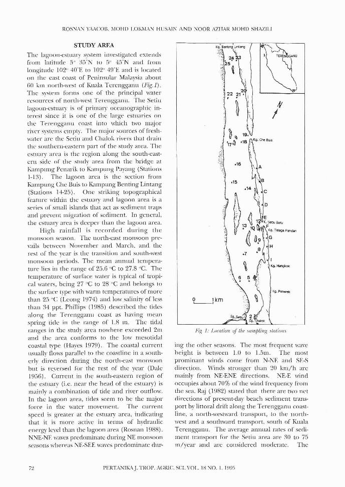
The lagO{)Jl-eSluary system investigatcd extendsfrom latitude 5" 35'N to 5" ·15'N and fromlongitudc 102" -W'E to 102" 49'E and is locatedon the east coast of Peninsular Malaysia about(i{) km north-west of Kuala Terenggallll (Fig. I) .
The system forms one of the principal waterresources of north-west Ten:ngganu. The Setinlagoon-estuary is of primal)' oceanographic interest since it is one of the large estuaries onthe Terengganu coast into which two Ill~jor
river systems empty. The m~jor sources of freshwater arc the Setiu and Chalok rivers that drainthe southern-eastern part of the study area. Theestuary area is the region along the south-eastern side of the study area from the bridge atKampung Pcnarik to Kampung Payang (Stations1-1:1). The lagoon area is the section fromKampung Che Buis to Kampung Benting Lintang(Stations 1:1-25), One striking' topographicalfeature within the estuary anrl lagoon area is aseries of small islands that act as sediment trapsand prevent migration of sediment. In general,the estual)' area is deeper than the lagoon area.
High rainfall is recorded during themonsoon season. The north-east monsoon prevails bet\\"'een Novcmher and ~"larch, and therest of the year is the transition and south-westmonSOOll periods. The mcan aunual temperature lies in the range of 25,6 "C to 27.8 "C. Thetemperature of surface water is typical of tropical waters, heing 27 "C to 28 "C and belongs tothe surf~lCe type with warm temperatures of morethan 25 "C (Leong 1974) and lowsalinit)' of1cssthan ~q ppt. Phillips (985) described the tidesalong the Terengganll coast as haYing meanspring tide in the range of 1.8 m. The tidalranges in the study area nowhere exceeded 2maud the area conforms to the }()\\: mesotidalcoastal type (Hayes 1979). The coastal currentusually flows parallel to the coastline in a southerly d.irection during the north-cast monsoonhut is reyersed for the rest of the year (Dale1956). Current in the south-eastern region ofthe estuary (i.e. near the head of the esmary) ismainly a combination of tide and river outflow.In the lagoon area, tides seem to be the llwjorforce in the water movement. The currentspeed is greater at the estual)' area, indicatingthat it is more active in terms of hydraulicenergy level than the lagoon arca (Rosnall 1988).NNE-NE waves predominate during NE monsoonseasons whereas NE-SEE w,n'cs predominate dur-
:~-
';.'.~~
, 22
~~
I
~~'17 il
.16
,15
~km
FiR I: !-o((/(i!m oj the samplinR .1/a/irH/\
mg thc other seasons. The most frequcnt 'wayeheight is between 1.0 to 1.5m. The mostprominant winds come from N-NE and SE-Sdirection. 'Vinds stronger than 20 km/h aremainly fi'om NE-ENE directions. NE·E windoccllpies ahollt 70% of the wind frequency Ii-omthe sea. R<~j (1982) stated that there are two netdirections of present-day beach sediment transport by littoral drift along the Terengganu coastline, a north-westward transport, to the northwest and a southward transport, south of" KualaTerengganu. The ayerage anllual rates of sediment transport for the Setiu area are ~() to 75Ill/year and are considered moderate. The
PERTANlhA.J. TROP. A(~RIC. SCI. VOL. IX NO. J. l~)~F)
SA~D CR_-\IN-SI7.E. D1STRmLTIO~ OF SEDI~'IENT IN THE VtCli':lTY OF SETIU L\GOON-f.STlIARY SYSTE~I
fl.l+
MATERIALS AND METHODS
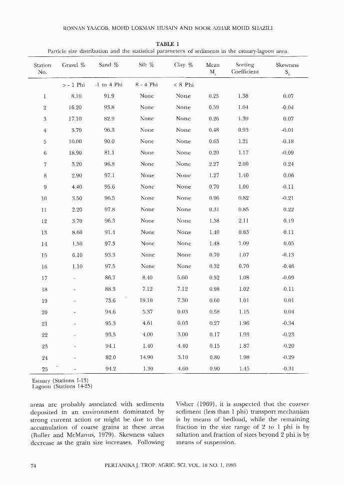
region all the samples were found to have arange in the sand classes. Visual examinationof thc coarse fraction (larger than two millinlCtres) shows that it is composed almost exclusively of carbonate detritus, mustly shell fragments. Sand percentages within the samplingsites range from 93.6 to ~)7.80%, silt betwcen 0and 22.36% and day hetween zero and 9.30%(Table I). Results shO\\'ed higher pern'nt<tgcsof sand in the estuary area, especially tll theinlet. At the outer inlet uf lagoon and adja{Tnl beach. the sedimenl consisted or 100%sand. Silt contenl was higher at the Cl'ntralpart and lower in the mid-channel of thelagoon. The silt percentagc generally dccreasedtoward the inlet and there is lower clay contentin the area away from the inlet. There is littlemixing of gravel and mud.
Plots of the graphic mean, sorting andskewness ,..tlllcs show estuary-lal-{ootl sedinH~nt
populations which call he related to spatialvariation. The range of mean grain size is O.1.~
- LiS phi. TIl(" mcan diametl.'r also indicatesthat most of the sediment in the system consistsof coarse to ycry fine sand, with greater prevalence of very fine sand size according to theclassification of \\'el1hvonh (1922). The fewsamples with a mcan grain-size (oarser thansand are lI11cf(lIallr dislributed but always occurat the in1c.:t area. Howcver mean bTfaill-size.:values at Stations II and 12 are ill Ihe medium10 coarse sand range and showed great variationin space and timc,
Sedimcnts in the lagoon-cstuary system han:a range or sorting coefficient of 0.82 - 2.11 phi.There W;'L'i a largc j.,Trottp of samples with asorting codlicient between I - 2 phi (poorlysorted). Z\'1ost of the remaining sampies showedsorting c.:odficielH near 0.90 phi (moderatelysorted). The sedimellts tt)r the.: most pan an..'poorly sorted, hut a signifi.cant portion of thearea is influellced by moderately sonerl sediment. The lowest values (best sorting) wcn:confincd to the region at Stations I anel 6, nearthe ht'ad of the eSIU<t1)' and lagoon respcctively.The hig-hest ,'allie (poorcst sorting) occurred atStation 12. In gencl..tl, sorting of scdiment improves as grain size dccreases.
Skewness values in the estu~\lY and lagoons}'stC::1ll range from -0.46 to -0.22. Positive valuesof skewness indicate that the normal size distribution is influenced by finer sizes. ~·lost of thesedilllelHs wcre Ile~ttively skewcd and thesc
2(0 95 - 0 5)+
011; + 2 0R4 - 2050
2(0 X4 - 0 IIi)
Skewness (\)
RESULTS AND DISCUSSION
The sedimcllts at the sampling sites ranged fromsand to sand)' loam. The sample colour wasIllOSI]V \'ellowish brown in the estual)' area anddark 'g;ey ill the lagoon area. In thc estuary
Sorting Coeflicient (0)
long-shure drift in both directions probably con~
tributes the C(uartz sanel making lip the bead1-
Mean U...I,)011i +050 + 0R4
Allahtiral Tedl1liqul'The 'sediment samples were air dried and 'luarlen~d bv hand (Krlllnhein and PcuUohn 1938).ASlllall"portioll oflhe samples (:")()- JOO g) ,vaslIscd for texlHral analrsis by the wct sieving andpipette 11H..'lhod 'L'i described by Bullcr and
lcAfanl1s (1979). The coarse fraction (particles\\'ith diameter b'Tetiter than -. phi or ()3 Jlll) wereanalysed llsing- the dry sicving technique. Basedon the data obtained, statistical measures werecalculated acconlin~ to the graphical measuresof Folk. aud Ward (19.:l/) as follows:-
5itll11p/inK Tr'tlmiqupThirty-four samples were colIcflerl wiLh anEkman grab sampler in Mar 1990 in the estuaryand lagoon areas (Fig. 1). At evcq- samplingstation senimclH sub---samplcs were taken fromthe centlT of the grab with a plastic corer (diameter 4.6 em ann length 25 em). The physicalappearancl.' of the.: scrlimcIH (sllch as colour andobserycd tcxtural classes) wcn: recorded on site.The beach samples wcre collected in plastic bagsfrom the fort..'shorc Cl'-ea at each station in October I~l90.
o R4 - (111i 0~)5 -05
I'ERT:\NIK.:\.J. TROI). AeRie_ SCI. VOl.. IX ~O. l. 19~t;l
ROSNAl\1 YAACOB, MOHD LOKMAN HUSAIN AND NOOR AZHAR 1'lOHD SHAZILI
TABLE 1P;:trtic1e size distribution and the statistical parameters of sediments in the estuary-lagoon area.
StationNo.
2
3
4
5
6
7
8
9
10
11
12
13
14
15
16
17
18
19
20
21
22
23
24
25
Gravel %
> - 1 Phi
8.10
16.20
17.10
3.70
10.00
18.90
3.20
2.90
4.40
3.50
2.20
3.70
8.60
1.50
6.10
1.10
Sand %
-1 to 4 Phi
91.9
93.8
82.9
96.3
90.0
81.1
96.8
97.1
95.6
96.5
97.8
96.3
91.4
97.3
93.3
97.5
86.7
88.3
73.6
94.6
95.3
93.5
94.1
82.0
94.2
SiIt %
8 - 4 Phi
None
None
None
None
None
None
None
None
None
None
None
Nonc
None
None
None
None
8.40
7.12
19.10
5.37
4.61
4.00
1.40
14.90
1.30
Clay %
< 8 Phi
None
None
None
None
None
None
None
None
None
None
None
None
None
None
None
None
5.60
7.12
7.30
0.03
0.03
3.00
4.40
3.10
4.60
MeanM
0.25
0.59
0.26
0.48
0.63
0.20
2.27
1.27
0.70
0.96
0.31
1.58
1.40
1.48
0.70
0.32
0.52
0.98
0.60
0.58
0.27
0.17
0.15
0.80
0.90
SortingCoeUicient
1.38
1.04
1.39
0.93
1.21
1.17
2.00
1.40
1.00
0.82
0.85
2.11
0.83
1.09
1.07
0.70
1.08
1.02
1.01
1.15
1.96
1.93
1.87
1.98
1.45
Skewness
S.
0.07
·0.04
0.07
·0.01
·0.18
·0.09
0.24
0.06
·(Ul
·0.21
0.22
0.19
·0.11
0.05
·0.13
·0.46
·0.09
·0.11
0.01
0.04
·0.:J4
·0.23
·0.20
·0.29
·0.31
Estuary (Stations 1-13)Lagoon (Stations 1+25)
areas are probably associated with sedimentsdeposited in an environment dominated bystrong current action or might be due to theaccumulation of coarse grains at these areas(Buller and McManus, 1979). Skewness valuesdecrease as the grain size increases. Following
Visher (1969), it is suspected that the coarsersediment (less than I phi) transport mechanismis by means of bedload, while the remainingfraction in the size range of 2 to 1 phi is bysaltation and fraction of sizes beyond 2 phi is bymeans of suspension.
74 PERTANIKAJ. TROP. AGRIe. SCI. VOL. IS NO.1, 1995
SAND GRAIN·SIZE DISTRIBUTION OF SEDIMENT IN THE V1CINllY OF SETIU lACOO '·ESTUARY ~iY~,TEM
TABLE 2The statistical parameters of the sediment at the SethI beach
Station Mean Sorting Skewness Type of SoningNo. M Coefficient (e
l) 5,
A 0.49 0.59 ·0.06 Moderately well sonc.:d
II 0.19 0.63 ·0.34 Moderatdy well sorted
C 0.58 0.84 ·0.26 Moderately suned
D 1.13 0.88 .0.04 Moderately sorted
E 0.88 0.67 .0.16 Moder,ueI}' well sorted
F 0.32 0.69 ·0.08 Moderately "'ell soned
C 0.87 0.84 ·0.10 !vloderalcly sorted
H 0.90 0.03 ·0.24 Moderately soned
0.98 0.78 0.1 I Moderately sorted
The data obtained by the dry sieving technique for all the composite beach sand arcsummarized in Table 2. Mean diameter rangedfrom 0.19 lO 1.13 phi. It was found that StationD had the smallest grain size of all stations. Themean diameters also indicate that most of thebeach sand consists of medium and fine-grainedsand. Beach sand generally increased towardsthe South. In areas near the river inlet, thesediment had a relatively coarser grain size withcoarser sand found to the south-west of the rivermouth.
The sorting coefficicm ranged from 0.59 to0.88, All stations had either moderately wellsorted or moderately sorted sediment. StationsA and B at the extremity away from the rivermouth had moderately well--soned sediment. Theskewness value w'as highest at Station I. Most ofthe beach sand was negatively skewed. Thisindicates that the beach sand has excess coarsefraction and the area is subjected to high waveenergy or is under the influence of strong currents.
CONCLUSION
The estuary area is composed of poorly sortedcoarse sediment and the lagoon area is ofmoderately sorted fine sediment. This showsthat the estuary area is more active in terms ofhydraulic energy level than the lagoon area.Furthennore, lack of silt and clay in the estuaryarea is attributable to a lack of depositionalprocesses under the influence of relatively
stronger currents compared to the lagoon areawhere depositional processes are active.
ACKNOWLEDGMENTS
The authors would like to thank Mr. NazukiSulong, Mr. Shahabudin Saad, Mr. SukimanSengat and Mr. Hamin Jusoh for the technicalassistance and Norshimah Ahmad for typing themanuscript. This project wat; supported by MajlisPenyelidikan dan Kemajuan Sains Negara(MPKS f) under the Intensified ResearchProgramme for Priority areas (IRPA) , Grant No:1-07·06 50260 through Universiti PertanianMalaysia.
REFERENCES
BVLU:R, A.T. and J. Mcw1A:'lllS. 1979. Sediment sampling and analysis. In Esluari,u! Hydrographyand Sedimentation. A Handbook., ed. KR Dycrp. 87-130. Cambridge: Cambridge UniversityPress.
DALE, \V.L. 1956. 'Vind and drift currents in theSouth China Sea. Tropical Geog.-aphyJoumal 8: 131.
FOLK, R.L. and W,e. WARD. 1957, Brazos river bar:a study in the significance of grain size parameter. Sedimentary' Petrolog), Jou771al 27: 3~26.
H.~'rl",), M.D. 1979. Barrier island morphology as arunction or tidal and wave regime. In Barrie,.Islands, ed. S.P. Leathennan, p. 1~29. NewYork: Academic Press.
PERTANIKAJ. TROP. AGRlG. SCI. VOL. 18 '0.1,1995 75
ROSNA:\ YA.Aeon. MOHD 1.0Ki\IAN HUSAIN AND NOOR AZHAR :\10HD SHAZII.I
H.ll·L....TRml, F. 19~V). Studies of the morphologicalactl\'ity of rivCfs as illustrated by the RiverFvris. [!nilwnit)' r~l ['lJS(I!a. Geolo~)' Bullt'lin 25:
22J-227.
j..l,.R.,H.\?\· PARIT D..l,:\ T.-\.I.IAiR ~vf.-\l •.\YS1:\. 1977. fZwlrologi
wI Data.minfall Rt'cords for Pt>lIiUSlllar iUalay.lia1970·1975. Kuala Lumpur: KementerianPertanian.
KRUIFlEI:-':, W.e. and FJ PETflJOII",'. 1938, Manual ofSf'dimPll1my Petrograph)', New York: ApplctonCentluy-Crofts.
LEO.'\(;. P.e. 1974. Hydrographic conditions oIl' theEast Coast of Peninsular 'Malaysia during August 1972, Mrtlaysirl11 Agricultum!}o/tJ"1lrd 49(4):-1-92-503,
PI'. rlllCK. J. 19H4. .A II- Tnl-rndurtioll to Coastal(;f'oJ/unpllO!()K)'. London: Edward A1'nok1.
PfHl.ur~, RP. 1985. Longshore transport of sedi·ment during August and September on theTerenggaJ1u Coast. P('Itanilw 8(2): 273-279.
R\j, J.K HI8:!. Net directions and rates of thepresent-day heach sedimcllt transport by littoral drift along the east coast of Peninsulari\1alaysia. Geologiral ,)'ol"if'ty /vlrtlaY.'iia Bullptin 15:57-70.
ROSi\.:A:\ Y-\ACOB. 1988. Geophysical studies in Setinlagoon-estuary system, \-1.5. thesis. UniversitiPertanian Malaysia.
S:\I.LEH, U. and \LL. HI'SAI:\. 19H6. Laporan K:.~jlan
Awal Kesesllaian Ailltu Air dan Dasar bagiSungai i\-'Ierang dan Setiu, Kuala Tercngganu,Univt:rsiti Pertanian :\lalaysia.
VISIIER, C.S. 19G9. Grain-size distribution anddepositional pnKcss. Sedilllf'1Itm)' Pdrolo,L,'J.!o/tma{ 39: 107+1108.
\VEXIWORTH, c.K. 1922. A scale of grade and classterms for clastic sediments. Gf'O!0f!:J}oumal 30::i77<W2,
(R('(('iwd 23 JUT1r /993)
7ll PERTANIK\j. TROP, A(;RIC. SCI. Val.. IH l\'O. 1. 199:i