climate change vulnerability assessment of semporna priority
TRANSCRIPT
Climate Change Vulnerability Assessment of Semporna Priority Conservation Area (PCA)
WWF-Malaysia Semporna PCA Project Report
with Universiti Malaysia Sabah
June 2015
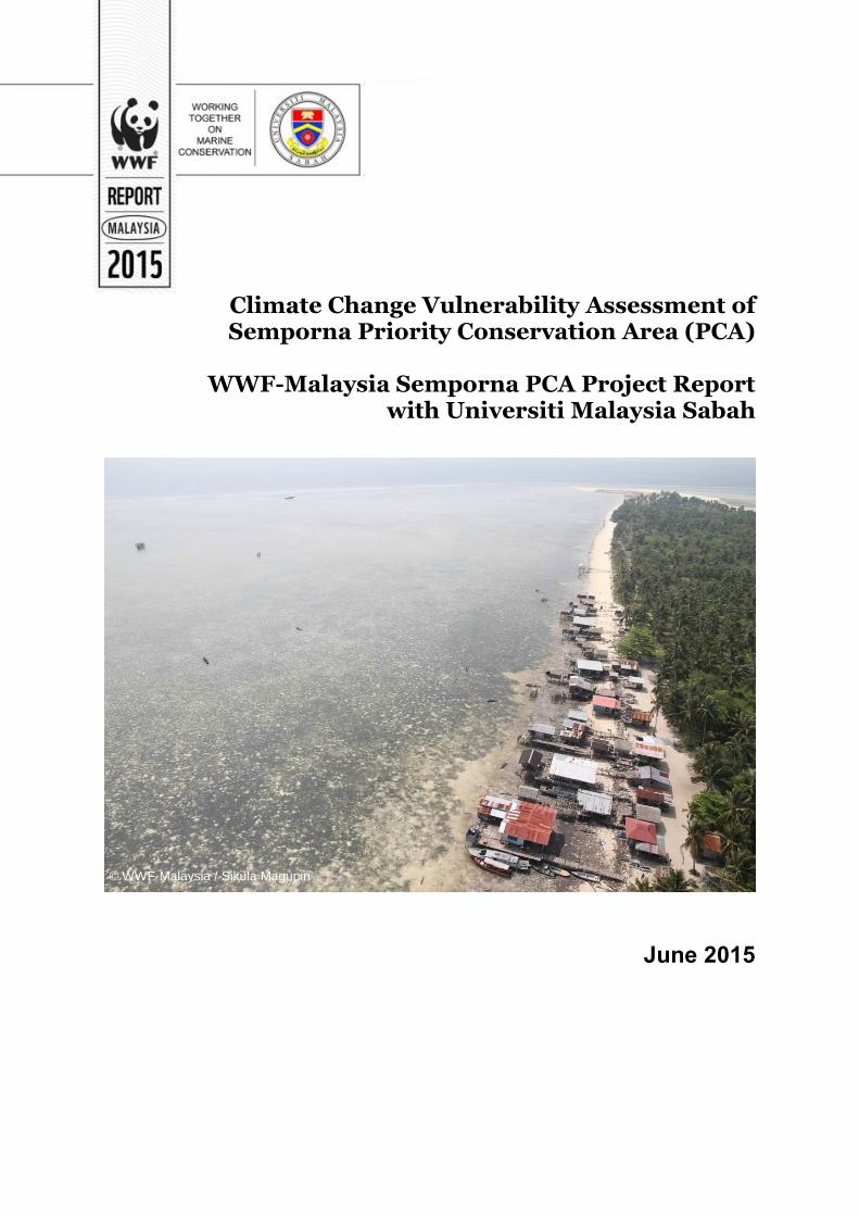
© WWF-Malaysia / Sikula Magupin
Published by:
WWF-Malaysia
1 Jalan PJS 5/28A,
Petaling Jaya Commercial Cemtre (PJCC)
46150 Petaling Jaya,
Selangor, Malaysia.
wwf.org.my
Copyright © 2015 WWF-Malaysia.
All rights reserved. No part of this publication may be reproduced,
Stored in a retrieval system, or transmitted in any form or by
any means, electronic, mechanical, photocopying, recording,
or otherwise, without the prior permission of the copyright
owner.
The opinions of the authors articulated in this
publication do not necessarily reflect those of WWF-
Malaysia.
Design and layout by Ejria Saleh and Gavin Jolis.
Technical editor: Lakshmi Lavanya Rama Iyer, Shantini Guna Rajan, Choo Poh
Leem, Monique Sumampouw.
Suggested citation:
Jolis, Gavin & Saleh, Ejria. (2015). Climate Change Vulnerability Assessment of
Semporna Priority Conservation Area (PCA): WWF-Malaysia.
Perpustakaan Negara Malaysia Cataloguing-in-Publication Data
Jolis, Gavin. 1987-
Climate Change Vulnerability Assessment of Semporna Priority
Conservation Area / by Gavin Jolis, Ejria Saleh
Bibliography: page 47
ISBN 978-967-0237-37-4
1. Climatic change--Research--Sabah.
1. Climate change mitigation--Sabah.
I. Ejria Saleh, 1971-, II. Title 551.695953
iii
Climate Change Vulnerability Assessment of Semporna Priority Conservation Area (PCA)
By
Gavin Jolis Ejria Saleh
Report Produced Under Project MA010501-GEN WWF-Malaysia Marine Programme
June 2015
iv
Table of Contents
Preface ................................................................................................................................... vii
Acknowledgements ............................................................................................................. viii Executive Summary ............................................................................................................... ix Ringkasan Eksekutif ............................................................................................................... x
1. Introduction ......................................................................................................................... 1
2. Assessment Objectives and Geographic Scope ............................................................... 4 2.1 Assessment objectives .................................................................................................. 4
2.2 Geographic scope .......................................................................................................... 4
3. Literature Review ................................................................................................................ 6
4. Coastal Integrity Vulnerability Assessment Tool (CIVAT) for Semporna PCA ......... 7 4.1 Methods and materials ................................................................................................. 7
4.1.1 Selection of sites to be assessed............................................................................ 7
4.1.2 Assessment of sites according to criteria .......................................................... 8
4.1.3 Scoring of sites ....................................................................................................... 9
4.1.4 Vulnerability computation of sites ................................................................... 10
4.2 Results .......................................................................................................................... 10
4.3 Discussion .................................................................................................................... 13
5. Local Early Action Planning (LEAP) for Selakan Island ............................................. 16 5.1 Method and Materials................................................................................................. 16
5.1.1. Getting organized for CCA planning ............................................................... 16
5.1.2 Telling your climate story .................................................................................. 17
5.1.3 Conducting a vulnerability assessment ........................................................... 18
5.1.4 Developing your local early action plan ......................................................... 19
5.2 Results .......................................................................................................................... 20
5.2.1 Community background .................................................................................... 20
5.2.2 Climate story........................................................................................................ 22
5.2.3 Historical timeline and seasonal calendar ..................................................... 24
5.2.4 Indicators of a changing climate ..................................................................... 28
5.2.5 Target resources and status .............................................................................. 31
5.2.6 Vulnerability assessment ................................................................................... 36
5.2.7 Priority adaptation actions and implementation schedule ......................... 39
5.2.8 Monitoring and evaluation approach ............................................................. 42
5.3 Discussion .................................................................................................................... 43
6. Limitations ......................................................................................................................... 44 7. Conclusion .......................................................................................................................... 45
8. References .......................................................................................................................... 47 9. Appendices ......................................................................................................................... 51
9.1 Exposure component rubrics .................................................................................... 51
v
9.2 Sensitivity component rubrics .................................................................................. 51
9.3 Adaptive capacity component rubrics ..................................................................... 52
9.4 CIVAT assessment sites ............................................................................................. 53
9.5 Vulnerability assessment matrix by target resources ............................................ 57
9.6 Adaptation options matrix by target resources ...................................................... 67
vi
Acronyms EAFM Ecosystem Approach to Fisheries Management ESSCOM Eastern Sabah Security Command CCA Climate change adaptation CIVAT Coastal Integrity Vulnerability Assessment Tool CT Coral Triangle CTI-CFF Coral Triangle Initiative on Coral Reefs, Fisheries and Food
Security cm/year Centimetre per year DSMM Department of Survey and Mapping Malaysia et al. And others ha Hectares ICZM Integrated Coastal Zone Management IPCC Intergovernmental Panel on Climate Change km Kilometre km2 Kilometre square LEAP Local Early Action Plan m metre MPA Marine Protected Areas NAHRIM National Hydraulic Research Institute of Malaysia PCA Priority Conservation Area pers. comm. Personal communication REAP Region-Wide Early Action Plan RM Ringgit Malaysia RSLR Relative sea level rise SSME Sulu-Sulawesi Marine Ecoregion TWG Technical Working Group UMS Universiti Malaysia Sabah UPMSI U.P. Marine Science Institute WWF World Wide Fund for Nature % Percentage
vii
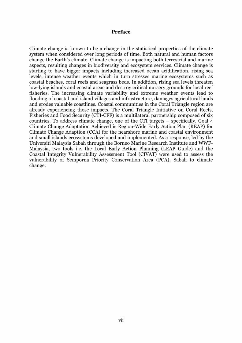
Preface Climate change is known to be a change in the statistical properties of the climate system when considered over long periods of time. Both natural and human factors change the Earth’s climate. Climate change is impacting both terrestrial and marine aspects, resulting changes in biodiversity and ecosystem services. Climate change is starting to have bigger impacts including increased ocean acidification, rising sea levels, intense weather events which in turn stresses marine ecosystems such as coastal beaches, coral reefs and seagrass beds. In addition, rising sea levels threaten low-lying islands and coastal areas and destroy critical nursery grounds for local reef fisheries. The increasing climate variability and extreme weather events lead to flooding of coastal and island villages and infrastructure, damages agricultural lands and erodes valuable coastlines. Coastal communities in the Coral Triangle region are already experiencing those impacts. The Coral Triangle Initiative on Coral Reefs, Fisheries and Food Security (CTI-CFF) is a multilateral partnership composed of six countries. To address climate change, one of the CTI targets – specifically, Goal 4 Climate Change Adaptation Achieved is Region-Wide Early Action Plan (REAP) for Climate Change Adaption (CCA) for the nearshore marine and coastal environment and small islands ecosystems developed and implemented. As a response, led by the Universiti Malaysia Sabah through the Borneo Marine Research Institute and WWF-Malaysia, two tools i.e. the Local Early Action Planning (LEAP Guide) and the Coastal Integrity Vulnerability Assessment Tool (CIVAT) were used to assess the vulnerability of Semporna Priority Conservation Area (PCA), Sabah to climate change.
viii
Acknowledgements
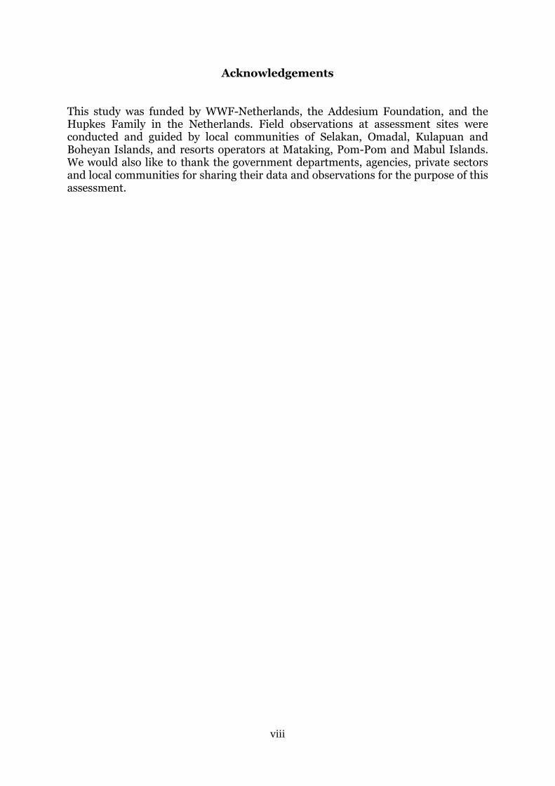
This study was funded by WWF-Netherlands, the Addesium Foundation, and the Hupkes Family in the Netherlands. Field observations at assessment sites were conducted and guided by local communities of Selakan, Omadal, Kulapuan and Boheyan Islands, and resorts operators at Mataking, Pom-Pom and Mabul Islands. We would also like to thank the government departments, agencies, private sectors and local communities for sharing their data and observations for the purpose of this assessment.
ix
Executive Summary WWF-Malaysia and Universiti Malaysia Sabah conducted a climate change vulnerability assessment for Semporna PCA between July 2013 and June 2014. The objectives of the assessment were to introduce and apply the Local Early Action Planning (LEAP Guide) and the Coastal Integrity Vulnerability Assessment Tool (CIVAT) in Semporna as tools to assess vulnerability, determine the vulnerability of those local communities and resources to climate change, followed by recommend adaptation measures to climate change. The CIVAT assessed the vulnerability of the coastal lines to erosion and inundation resulting from wave impact and sea level rise for eight sites (A-H). The LEAP, a community-approach tool in identifying vulnerabilities of ecological and social targets, was used to assess Selakan Island, one of the islands found within the Tun Sakaran Marine Park. The CIVAT tool determined the vulnerability of Semporna PCA ranges from low to high. Sites C to E (Denawan, Si Amil Ligitan; Mabul and Sipadan Islands) (1.77%, 13.36km) are highly vulnerable to climate change. Sites A, B, F and H (Bum-Bum, Tun Sakaran Marine Park, Northeast Islands, and south Semporna mainland) (49.30%, 373.01km) are medium while vulnerability of the site G (north Semporna mainland) (48.93%, 370.17km) is low. The recommended adaption measures for the highly vulnerable sites are:
Implementation of proper development along the sites taking accounts of climate change impacts;
Possible relocation of highly vulnerable communities to mainland or other safer areas, and
Protection or restoration of key marine habitats. The LEAP tool identified three ecological and five social targets with vulnerabilities ranges from medium to high. Coral reefs, seaweed cultivation and sea cucumber harvesting are highly vulnerable, followed by seagrass beds, fringing mangrove trees, fish cage cultures, bed and breakfast lodging and goat farming which are medium in vulnerability. Priority adaptation options suggested are:
Strengthening the enforcement of park regulations to reduce negative pressure on coral reefs;
Coral reef restoration,
Application of best practices for seaweed farming including proper management;
Retrofitting infrastructures to withstand climate change and other natural hazards for Bed and Breakfast lodging, and
A local management plan for sea cucumber for the community to be put in place.
x
Ringkasan Eksekutif WWF-Malaysia dan Universiti Malaysia Sabah (melalui Institut Penyelidikan Marin Borneo) telah menjalankan penilaian ancaman perubahan iklim untuk Semporna antara Julai 2013 dan Jun 2014. Objektif-objektif penilaian ini adalah untuk memperkenalkan dan mengaplikasikan LEAP dan CIVAT di Semporna sebagai kaedah penilaian; menentukan ancaman komuniti dan sumber kepada perubahan iklim, dan mencadangkan langkah-langkah penyesuaian kepada perubahan iklim di Semporna. CIVAT menilai ancaman pesisiran pantai kepada hakisan dan banjir akibat daripada kesan ombak dan kenaikan paras air laut. LEAP adalah suatu kaedah yang menggunakan pendekatan komuniti dalam mengenal pasti ancaman sasaran ekologi dan sosial kepada perubahan iklim, telah digunakan untuk menilai Pulau Selakan, salah satu pulau di Taman Marin Tun Sakaran. Ancaman perubahan iklim di Semporna mempunyai julat dari rendah ke tinggi berdasarkan CIVAT. Lokasi-lokasi C hingga E (Pulau-pulau Denawan, Si Amil, Ligitan; Mabul dan Sipadan) (1.77%, 13.36km) mempunyai ancaman yang tinggi. Ancaman lokasi-lokasi A, B, F dan H (Pulau-pulau Bum-Bum, Taman Marin Tun Sakaran, pulau timur laut dan selatan tanah besar Semporna) (49.30%, 373.01km) adalah sederhana manakala lokasi G (utara tanah besar Semporna) (48.93%, 370.17km) adalah rendah. Langkah-langkah penyesuaian yang dicadangkan untuk lokasi-lokasi C hingga E termasuklah pelaksanaan pembangunan pelancongan yang betul di sepanjang pesisiran pantai yang mengambil kira kesan perubahan iklim; penempatan semula kepada komuniti seperti dari Pulau Mabul ke tanah besar atau kawasan-kawasan yang lebih selamat, dan perlindungan habitat-habitat marin. Tiga sasaran ekologi dan lima sasaran sosial di Pulau Selakan mempunyai julat ancaman dari sederhana ke tinggi. Ancaman terumbu karang, penanaman rumpai laut dan penuaian timun laut adalah tinggi, diikuti dengan rumpai laut, pokok-pokok bakau, penuaian ikan dalam sangkar, penginapan pelancongan dan penternakan kambing adalah sederhana. Langkah-langkah penyesuaian yang dicadangkan adalah:
Mengukuhkan penguatkuasaan peraturan-peraturan taman bagi mengurangkan tekanan negatif kepada habitat marin;
Pemulihan terumbu karang;
Aplikasi amalan terbaik untuk penanaman rumpai laut termasuk pengurusan;
Infrastruktur yang kuat untuk menghadapi perubahan iklim dan bencana alam yang lain untuk penginapan pelancongan, dan
Pelan pengurusan untuk timun laut untuk komuniti.
1
1. Introduction Climate change is known to be a change in the statistical properties of climate system in the long-term. Both natural (changes in Earth’s orbit, solar activity and volcanic eruptions) and human factors (mainly continuous production of heat-trapping greenhouse gases) change the Earth’s climate. Evidence of climate change can be based on the reconstruction of past climates such as temperature and salinity or it can be also observed from the melting of mountain glaciers and polar ice, global sea-level rise and changing of precipitation pattern (Cazenave & Nerem, 2004; IPCC, 2007; Fredolin et. al, 2012). Climate change is starting to have bigger impacts including increased ocean acidification, rising sea levels, intense weather events which in turn stresses marine ecosystems, coastal beaches, coral reefs and seagrass beds (Wilkinson, 2008: Connolly, 2009). In addition, rising sea levels threaten low-lying islands and coastal areas and destroy critical nursery grounds for local reef fisheries. Increasing climate variability and extreme weather events lead to flooding of coastal and island villages and infrastructure, damages agricultural lands and erodes valuable coastlines. The Coral Triangle region located along the equator at the confluence of the Western Pacific Ocean and Indian Ocean covers all or part of the exclusive economic zones of six countries: Indonesia, Malaysia, Papua New Guinea, the Philippines, the Solomon Islands, and Timor-Leste. Considered the global epicenter of marine life abundance and diversity, the region possesses 76% of all known coral species, 37% of all known coral reef fishes, 53% of the world’s coral reefs, the greatest extent of mangrove forests in the world, and spawning and juvenile growth areas for the world’s largest tuna fishery (CTI-CFF, 2009). The Coral Triangle (CT), which includes almost 4 million hectares of ocean and coastal waters, is home to 390 million people; 130 million of which directly depend on these resources for their livelihood and wellbeing. However, coastal communities in the CT region are already experiencing the impacts of climate change. Severe storms, coastal inundation, rising sea level and sea surface temperature are threatening safety and food security of more than 120 million people that depend directly on local marine and coastal resources for their income and livelihood. The Coral Triangle Initiative on Coral Reefs, Fisheries and Food Security (CTI-CFF) is a multilateral partnership composed of six countries, namely, Indonesia, Malaysia, Papua New Guinea, Philippines, Solomon Islands and Timor-Leste. This initiative consists of five goals which are; Goal 1: Priority Seascapes (large marine areas) designated and effectively managed, Goal 2: Ecosystem approach to management of fisheries (EAFM) and other marine resources fully applied, Goal 3: Marine protected areas (MPAs) established and effectively managed, Goal 4: Climate change adaptation measures achieved and Goal 5: Threatened species status improving. To address climate change, one of the CTI-Goal 4 target in the regional level is Region-wide Early Action Plan (REAP) for Climate Change Adaptation (CCA) for the nearshore marine and coastal environment and small islands ecosystems developed and implemented. As response from this target, the Coral Triangle Initiative (CTI) Climate Change Adaptation (CCA) Technical Working Group (TWG) has developed various CCA Toolkits as guidance to support the local implementation of the CTI-REAP-CCA.
2
Malaysia, situated outside of the Pacific Rim is not considered a hotspot for natural disturbance. It was ranked 90th in the world being protected from high exposure to natural calamities (United Nations University, 2013). However, based on trends and projections of climate hazards in Malaysia, it is expected that there is increasing air and sea surface temperatures, rising sea level, more intense and frequent typhoons, changes in the amount and pattern of rainfall and ocean acidification. However, it is expected that the coastal zone and communities living within these areas are less likely to be vulnerable to the negative impacts of climate change as compared to other nearby countries such as Philippines and Indonesia. Nonetheless, every effort should be made to integrate climate change adaptation planning into existing or established processes of local governments and communities’ development plans to strengthen their capacity to cope with impacts of climate change, to improve resilience, and disaster preparedness. Some of Malaysia’s climatic change parameters are in line with regional and global trends. Average surface temperature increased and very much correlated to the El Niño events while rainfall trends are not clearly defined as this parameter has large spatial and temporal variation (Malaysian Meteorology Department, 2009). Over the twentieth century, global sea level increase at an average rate of 2 mm yr-1, which is substantially larger than the rate of the previous three millennia (Willis, et al., 2010). On a national level, based on satellite altimeters data analyses, the sea level in Malaysia is rising at a rate of 1.42 – 4.08 mm per year (Ami Hassan et al., 2009). However, there is variation of sea level rise rate within different places in Malaysia (NAHRIM, 2010). Natural threats to marine ecosystem and its biological diversity include storms, strong waves and wind during the peak of monsoons season. Edang et al. (2008) reported that these events can contribute to destruction of seaweed and seagrass beds. At the southeast corner of the Malaysian Bornean state of Sabah, lies the Semporna district and Semporna town. The town, at the eastern tip of the Semporna Peninsula is the main trading town for more than 50 islands. The district and its waters are recognised as a Globally Outstanding Priority Conservation Area (PCA) within the Sulu-Sulawesi Marine Ecoregion (SSME), at the apex of the Coral Triangle. The Semporna PCA has a high coral, fish and shrimp taxa richness that rivals the top spots in the Coral Triangle, productivity of its marine habitats and is frequently used as migratory pathways of many marine species including marine turtles and whale sharks (Kassem et al., 2012). Heavy rainfall contributes to the intrusion of high suspended sediment from the mainland which changes the water quality and visibility of the water in Semporna (Komilus et al., 2011). Led by Universiti Malaysia Sabah through the Borneo Marine Research Institute, the CTI-CFF Climate Change Adaptation for Coral Triangle Communities: A Guide for Vulnerability Assessment and Local Early Action Planning (LEAP Guide) (United States Coral Triangle Initiative Support Program, 2013) and the Coastal Integrity Vulnerability Assessment Tool (CIVAT) (Siringan et al., 2013) were used to assess the vulnerability of Semporna PCA to climate change. These tools were developed by the Coral Triangle Initiative (CTI) CCA Technical Working Group (TWG) and Marine Science Institute of the University of the Philippines (UPMSI) and are encouraged to be applied among the CT regions. LEAP was developed as a companion document to assist local governments and communities in identifying strategic and practical actions to address the impacts of climate change at community-level. It involves community participation and knowledge of surrounding marine environment.
3
CIVAT was developed to assess the vulnerability of coastal area to erosion and inundation resulting from wave impact and sea level rise according to the criteria under exposure, sensitivity and adaptive capacity. This technical report outlines the assessment planning process and provides the results and recommends adaptation measures based upon the LEAP and CIVAT.
4
2. Assessment Objectives and Geographic Scope 2.1 Assessment objectives The aim of this assessment was to establish a climate change vulnerability assessment in Semporna PCA. The objectives of the assessment were to:
Introduce and apply the LEAP and CIVAT in Semporna as tools to assess vulnerability to climate change;
Determine the vulnerability of local communities and resources to climate change, and
Recommend adaptation measures to climate change in Semporna PCA. The result of the assessment would provide necessary information to determine and implement recommended adaptation measures to decision makers (government agencies, project managers, and policy makers) for the protection of local communities, private sectors (i.e. tourism) and the fragile marine ecosystems in the area; to ensure that marine ecosystems in Semporna continue to provide food, services and income for the people of Semporna in an equitable way, through integrated management approaches amongst various sectors ensuring the sustainability of natural resources. The assessment was conducted from July 2013 to June 2014. Part of the assessment was conducted during the imposed curfew by Eastern Sabah Security Command (ESSCOM) as a result from the Lahad Datu standoff, which started in February 2013, and provided limitations to the team (See Section 6). The CIVAT tool was selected to assess the whole area of the Semporna PCA. A stakeholder’s consultation workshop was conducted in Semporna on September 2013, and it was agreed that Selakan, a community-inhabited island in Tun Sakaran Marine Park will be assessed, with LEAP being chosen as the assessment tool to provide an example of community-based approach in the climate change vulnerability assessment. 2.2 Geographic scope The Semporna district is bounded on the west by the districts of Kunak and Tawau, while on the north and south lays inlets of the Darvel Bay and Sulawesi Sea respectively (Figure 1). The district contains Sipadan Island and Tun Sakaran Marine Parks, which are Marine Protected Areas (MPA) within the PCA managed by a government agency, Sabah Parks. Approximately 7,680km2, the PCA contains marine ecosystems dominated by corals with a rich mix of species of other important habitats such as mangrove forests, seagrass beds and seaweed around the island and fringing the coastal line. These unique ecosystems support livelihoods of thousands
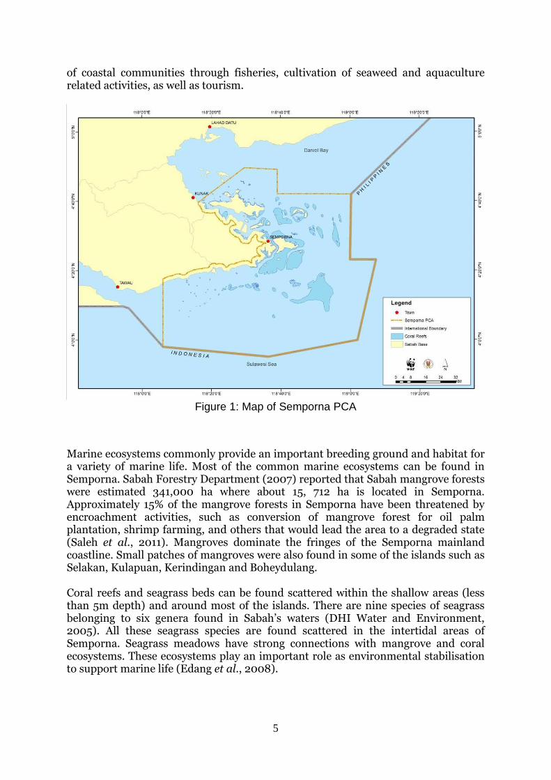
5
of coastal communities through fisheries, cultivation of seaweed and aquaculture related activities, as well as tourism.
Figure 1: Map of Semporna PCA
Marine ecosystems commonly provide an important breeding ground and habitat for a variety of marine life. Most of the common marine ecosystems can be found in Semporna. Sabah Forestry Department (2007) reported that Sabah mangrove forests were estimated 341,000 ha where about 15, 712 ha is located in Semporna. Approximately 15% of the mangrove forests in Semporna have been threatened by encroachment activities, such as conversion of mangrove forest for oil palm plantation, shrimp farming, and others that would lead the area to a degraded state (Saleh et al., 2011). Mangroves dominate the fringes of the Semporna mainland coastline. Small patches of mangroves were also found in some of the islands such as Selakan, Kulapuan, Kerindingan and Boheydulang. Coral reefs and seagrass beds can be found scattered within the shallow areas (less than 5m depth) and around most of the islands. There are nine species of seagrass belonging to six genera found in Sabah’s waters (DHI Water and Environment, 2005). All these seagrass species are found scattered in the intertidal areas of Semporna. Seagrass meadows have strong connections with mangrove and coral ecosystems. These ecosystems play an important role as environmental stabilisation to support marine life (Edang et al., 2008).
6
3. Literature Review There are various methods to assess the vulnerability to climate change of coastal communities and the marine resources, which they depend on. Since 2011, the Coral Triangle Initiative (CTI) CCA Technical Working Group (TWG) provided directions and introduced toolkits containing 4 tools to access vulnerability in the CT region. The 4 tools are:
• CTI-CFF Climate Change Adaptation for Coral Triangle Communities: A Guide for Vulnerability Assessment and Local Early Action Planning (LEAP Guide);
• Integrated Coastal Sensitivity, Exposure, and Adaptive Capacity to Climate Change (ICSEA-C-Change);
• Coastal Integrity Vulnerability Assessment Tool (CIVAT), and
• Tool for Understanding Resilience of Fisheries (TURF). The LEAP guide was used by WorldFish, WWF-Solomon Island and Western Provincial Government Coral Triangle Support Partnership (CTSP) to assess the vulnerability of the Saeraghi and Paelonge in the Western Province of Solomon Island (Abernerthy et al., 2012). The community adaptation options identified by communities had a strong focus on building and protecting the natural resources the communities had available to them, including sustainable resource use. The TURF and CIVAT tools were used at the province of Bantangas, Philippines by the Provincial Government Environment and Natural Resources Office (PGENRO) in partnership with CTSP. About 33% of the coastal barangays in the province have fisheries that are highly vulnerable to the effects of climate change due to high exposure to climate change, high sensitivity and low adaptive capacity of the fisheries, reef ecosystem and socioeconomic condition. Approximately 29% of the total barangays assessed have coastal areas that are highly vulnerable (Conservation International, 2013). In Malaysia, climate change assessment through CIVAT was done in Sabah and Sarawak to assess the vulnerability of the coastal area to erosion and inundation. Athira et al. (2014) found that the northeast parts of Labuan Island (East of Malaysia) are more vulnerable to climate change as compared to other areas of the island due to high sensitivity (facing open the sea) and low adaptive capacity. The other parts of the island are low to medium in vulnerability due to presence of fringing mangroves and shoreline protections. Similarly, Ismail (2012) indicates that the Kudat areas experienced medium to high vulnerability of climate change due to high exposure to typhoons and facing open sea. In southwest Sarawak, preliminary results of Semantan, Sampadi, Buntal and Santubong coasts show medium to high vulnerability whereby some sites have lack of continuous coastal habitats to serve as natural barriers and protection to possible storms or rising sea levels with direct exposure to the South China Sea (Mujahid & Mueller, 2015).
7
4. Coastal Integrity Vulnerability Assessment Tool (CIVAT) for Semporna PCA
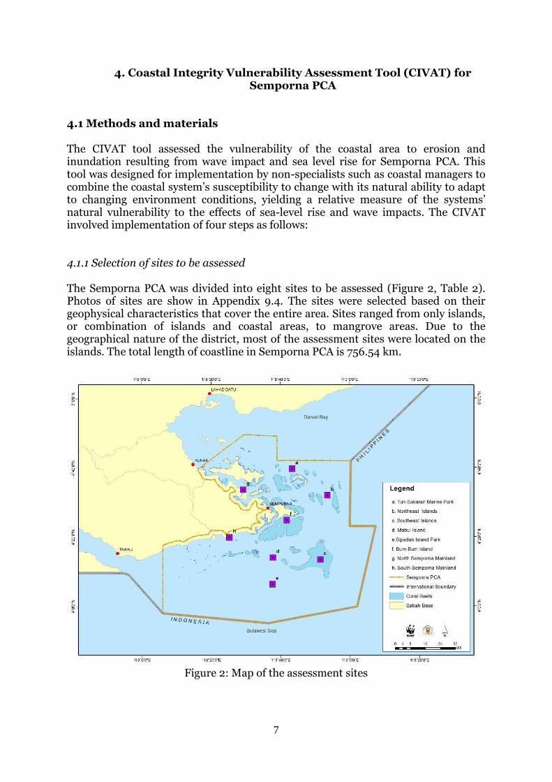
4.1 Methods and materials The CIVAT tool assessed the vulnerability of the coastal area to erosion and inundation resulting from wave impact and sea level rise for Semporna PCA. This tool was designed for implementation by non-specialists such as coastal managers to combine the coastal system’s susceptibility to change with its natural ability to adapt to changing environment conditions, yielding a relative measure of the systems’ natural vulnerability to the effects of sea-level rise and wave impacts. The CIVAT involved implementation of four steps as follows: 4.1.1 Selection of sites to be assessed The Semporna PCA was divided into eight sites to be assessed (Figure 2, Table 2). Photos of sites are show in Appendix 9.4. The sites were selected based on their geophysical characteristics that cover the entire area. Sites ranged from only islands, or combination of islands and coastal areas, to mangrove areas. Due to the geographical nature of the district, most of the assessment sites were located on the islands. The total length of coastline in Semporna PCA is 756.54 km.
Figure 2: Map of the assessment sites
8
Table 2: Assessed sites for CIVAT Site Length of
coastline (km)
Description
A 38.39 Tun Sakaran Marine Park: Bodgaya, Boheydulang, Tetagan, Selakan, Sebangkat, Maiga, Sibuan and Mantabuan Islands
B 19.11 Northeast Islands: Kulapuan, Pom-Pom, Pandanan, Boheyan, Mataking and Timba-Timba
C 9.69 Southeast Islands: Denawan, Si Amil and Ligitan D 2.05 Mabul Island E 1.62 Sipadan Island Park F 92.21 Bum-Bum, Omadal, Gusungan, Karindingan, Menampilik and
Nusa Tengah Islands G 370.17 Timbun Mata Island along with other smaller islands, and
coastal mangrove forests H 223.30 Semporna town, mangrove forests and mudflats
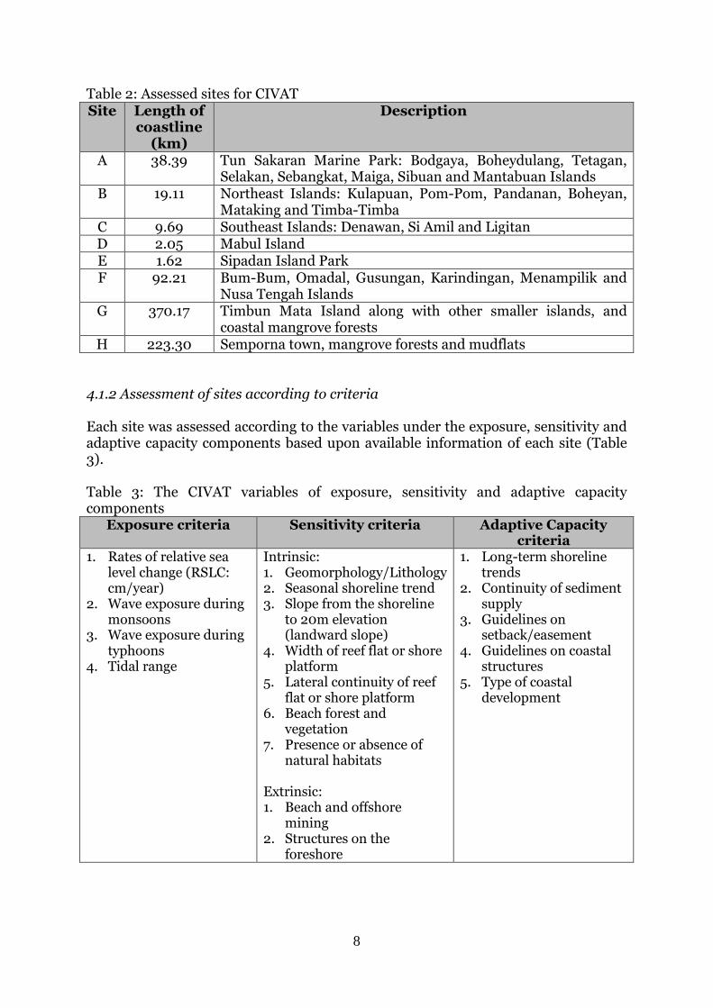
4.1.2 Assessment of sites according to criteria Each site was assessed according to the variables under the exposure, sensitivity and adaptive capacity components based upon available information of each site (Table 3). Table 3: The CIVAT variables of exposure, sensitivity and adaptive capacity components
Exposure criteria Sensitivity criteria Adaptive Capacity criteria
1. Rates of relative sea level change (RSLC: cm/year)
2. Wave exposure during monsoons
3. Wave exposure during typhoons
4. Tidal range
Intrinsic: 1. Geomorphology/Lithology 2. Seasonal shoreline trend 3. Slope from the shoreline
to 20m elevation (landward slope)
4. Width of reef flat or shore platform
5. Lateral continuity of reef flat or shore platform
6. Beach forest and vegetation
7. Presence or absence of natural habitats
Extrinsic: 1. Beach and offshore
mining 2. Structures on the
foreshore
1. Long-term shoreline trends
2. Continuity of sediment supply
3. Guidelines on setback/easement
4. Guidelines on coastal structures
5. Type of coastal development
9
4.1.3 Scoring of sites Each variable is assigned a relative score between 1 and 5, corresponding to Low (L) (1-2 points), Medium (M) (3-4 points), and High (H) (5 points) based on the magnitude of their contribution to physical changes on the coast in relation to waves and sea level change. Exposure criteria are to assess physical processes affecting the island such as sea level change, wave exposure during monsoon and tidal range. Detailed information of low, medium and high criteria are shown in Appendix 9.1. After exposure assessment had been completed, assessment on sensitivity of each site was done. Two factors were involved in order to assess sensitivity criteria (Appendix B). The sensitivity consists of intrinsic factors and extrinsic factors. Intrinsic factors are ecological, physiological or behavioural response of the island to climate change which includes coastal landform and the rock type, seasonal shoreline trend, slope from shoreline to 20m elevation, width of reef flat or shore platform, beach forest or vegetation, lateral continuity of reef flat or shore platform and coastal habitats. Extrinsic factors are existence of barriers to habitat migration as examples are coastal and offshore mining (includes removal of fossilised corals on the fringing reef and beach) and structures on the foreshore. Details on the criteria assessed are shown in Appendix 9.2. Adaptive capacity components are defined as the ability of a system to adjust to climate change impacts and to reduce potential damages, to take advantage of opportunities or to cope with the consequences. Adaptive Capacity were assessed by five criteria (Appendix 9.3) such as long term shoreline trends, continuity of sediment supply, guidelines on coastal structures, type of coastal development and coastal habitat. Scores for each criterion in exposure, sensitivity and adaptive capacity were aggregated and re-scaled into Low (L), Medium (M) and High (H). The range of scores for rescaling is dependent on the difference between the highest and lowest scores possible. The scores given were based on the primary and secondary data obtained. Primary data, such as through field observation and informal interviews with local communities and resort operators. Secondary data used were such as literature review, field trip reports, studies done by academia, marine chart, the topographic, bathymetric and geological maps obtained from Royal Malaysian Navy and Department of Survey and Mapping Malaysia. Field observation on coastal landform and rock types, types of the beach vegetation, structures on the foreshore and type of coastal development in the study sites were done on 28 March and 29 May 2014. During the trips, random informal interview with coastal communities in Semporna were made in order to support several criteria that have either little or no other available data. Informal interviews with resort operators, fishermen and local villagers who had lived in the island since birth, fishermen and resort operators.
10
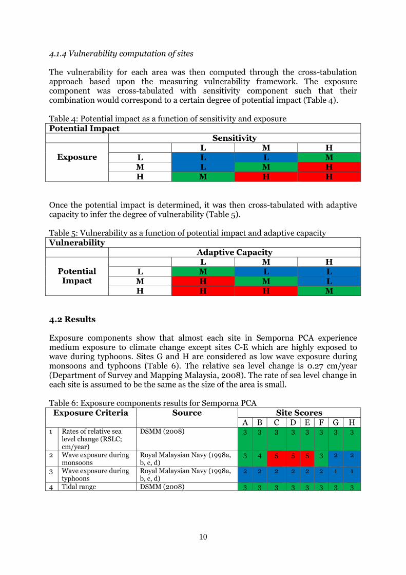
4.1.4 Vulnerability computation of sites The vulnerability for each area was then computed through the cross-tabulation approach based upon the measuring vulnerability framework. The exposure component was cross-tabulated with sensitivity component such that their combination would correspond to a certain degree of potential impact (Table 4). Table 4: Potential impact as a function of sensitivity and exposure Potential Impact Sensitivity
Exposure L M H
L L L M M L M H H M H H
Once the potential impact is determined, it was then cross-tabulated with adaptive capacity to infer the degree of vulnerability (Table 5). Table 5: Vulnerability as a function of potential impact and adaptive capacity Vulnerability Adaptive Capacity
Potential Impact
L M H L M L L M H M L H H H M
4.2 Results Exposure components show that almost each site in Semporna PCA experience medium exposure to climate change except sites C-E which are highly exposed to wave during typhoons. Sites G and H are considered as low wave exposure during monsoons and typhoons (Table 6). The relative sea level change is 0.27 cm/year (Department of Survey and Mapping Malaysia, 2008). The rate of sea level change in each site is assumed to be the same as the size of the area is small. Table 6: Exposure components results for Semporna PCA Exposure Criteria Source Site Scores
A B C D E F G H 1 Rates of relative sea
level change (RSLC; cm/year)
DSMM (2008) 3 3 3 3 3 3 3 3
2 Wave exposure during monsoons
Royal Malaysian Navy (1998a, b, c, d)
3 4 5 5 5 3 2 2
3 Wave exposure during typhoons
Royal Malaysian Navy (1998a, b, c, d)
2 2 2 2 2 2 1 1
4 Tidal range DSMM (2008) 3 3 3 3 3 3 3 3
11
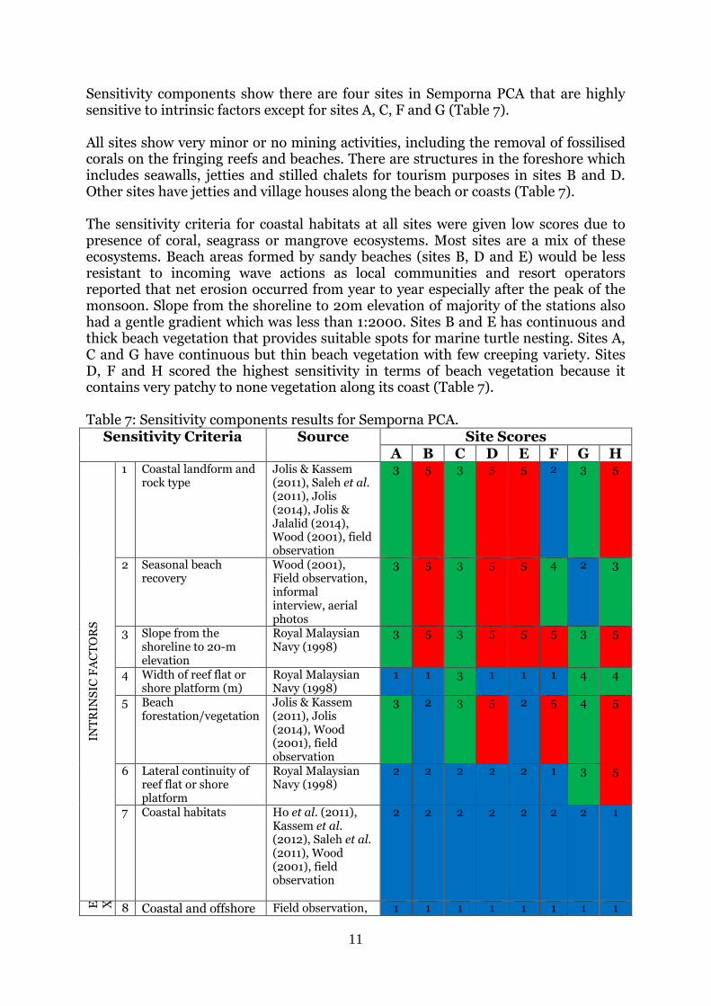
Sensitivity components show there are four sites in Semporna PCA that are highly sensitive to intrinsic factors except for sites A, C, F and G (Table 7). All sites show very minor or no mining activities, including the removal of fossilised corals on the fringing reefs and beaches. There are structures in the foreshore which includes seawalls, jetties and stilled chalets for tourism purposes in sites B and D. Other sites have jetties and village houses along the beach or coasts (Table 7). The sensitivity criteria for coastal habitats at all sites were given low scores due to presence of coral, seagrass or mangrove ecosystems. Most sites are a mix of these ecosystems. Beach areas formed by sandy beaches (sites B, D and E) would be less resistant to incoming wave actions as local communities and resort operators reported that net erosion occurred from year to year especially after the peak of the monsoon. Slope from the shoreline to 20m elevation of majority of the stations also had a gentle gradient which was less than 1:2000. Sites B and E has continuous and thick beach vegetation that provides suitable spots for marine turtle nesting. Sites A, C and G have continuous but thin beach vegetation with few creeping variety. Sites D, F and H scored the highest sensitivity in terms of beach vegetation because it contains very patchy to none vegetation along its coast (Table 7). Table 7: Sensitivity components results for Semporna PCA.
Sensitivity Criteria Source Site Scores A B C D E F G H
INT
RIN
SIC
FA
CT
OR
S
1 Coastal landform and rock type
Jolis & Kassem (2011), Saleh et al. (2011), Jolis (2014), Jolis & Jalalid (2014), Wood (2001), field observation
3 5 3 5 5 2 3 5
2 Seasonal beach recovery
Wood (2001), Field observation, informal interview, aerial photos
3 5 3 5 5 4 2 3
3 Slope from the shoreline to 20-m elevation
Royal Malaysian Navy (1998)
3 5 3 5 5 5 3 5
4 Width of reef flat or shore platform (m)
Royal Malaysian Navy (1998)
1 1 3 1 1 1 4 4
5 Beach forestation/vegetation
Jolis & Kassem (2011), Jolis (2014), Wood (2001), field observation
3 2 3 5 2 5 4 5
6 Lateral continuity of reef flat or shore platform
Royal Malaysian Navy (1998)
2 2 2 2 2 1 3 5
7 Coastal habitats Ho et al. (2011), Kassem et al. (2012), Saleh et al. (2011), Wood (2001), field observation
2 2 2 2 2 2 2 1
E X T R I N S I C F A C T O R S
8 Coastal and offshore Field observation, 1 1 1 1 1 1 1 1
12
mining (includes removal of fossilized corals on the fringing reef and beach)
informal interview
9 Structure on the foreshore
Field observation 2 3 2 4 3 2 2 3
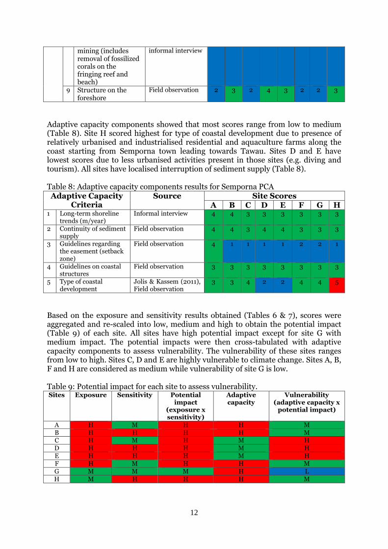
Adaptive capacity components showed that most scores range from low to medium (Table 8). Site H scored highest for type of coastal development due to presence of relatively urbanised and industrialised residential and aquaculture farms along the coast starting from Semporna town leading towards Tawau. Sites D and E have lowest scores due to less urbanised activities present in those sites (e.g. diving and tourism). All sites have localised interruption of sediment supply (Table 8). Table 8: Adaptive capacity components results for Semporna PCA Adaptive Capacity
Criteria Source Site Scores
A B C D E F G H 1 Long-term shoreline
trends (m/year) Informal interview 4 4 3 3 3 3 3 3
2 Continuity of sediment supply
Field observation 4 4 3 4 4 3 3 3
3 Guidelines regarding the easement (setback zone)
Field observation 4 1 1 1 1 2 2 1
4 Guidelines on coastal structures
Field observation 3 3 3 3 3 3 3 3
5 Type of coastal development
Jolis & Kassem (2011), Field observation
3 3 4 2 2 4 4 5
Based on the exposure and sensitivity results obtained (Tables 6 & 7), scores were aggregated and re-scaled into low, medium and high to obtain the potential impact (Table 9) of each site. All sites have high potential impact except for site G with medium impact. The potential impacts were then cross-tabulated with adaptive capacity components to assess vulnerability. The vulnerability of these sites ranges from low to high. Sites C, D and E are highly vulnerable to climate change. Sites A, B, F and H are considered as medium while vulnerability of site G is low. Table 9: Potential impact for each site to assess vulnerability. Sites Exposure Sensitivity Potential
impact (exposure x sensitivity)
Adaptive capacity
Vulnerability (adaptive capacity x
potential impact)
A H M H H M B H H H H M C H M H M H D H H H M H E H H H M H F H M H H M G M M M H L H M H H H M
13
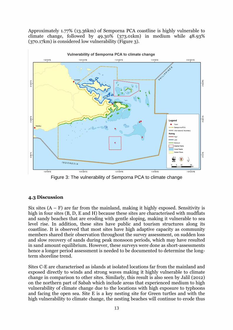
Approximately 1.77% (13.36km) of Semporna PCA coastline is highly vulnerable to climate change, followed by 49.30% (373.01km) in medium while 48.93% (370.17km) is considered low vulnerability (Figure 3).
Figure 3: The vulnerability of Semporna PCA to climate change
4.3 Discussion Six sites (A – F) are far from the mainland, making it highly exposed. Sensitivity is high in four sites (B, D, E and H) because these sites are characterised with mudflats and sandy beaches that are eroding with gentle sloping, making it vulnerable to sea level rise. In addition, these sites have public and tourism structures along its coastline. It is observed that most sites have high adaptive capacity as community members shared their observation throughout the survey assessment, on sudden loss and slow recovery of sands during peak monsoon periods, which may have resulted in sand amount equilibrium. However, these surveys were done as short-assessments hence a longer period assessment is needed to be documented to determine the long-term shoreline trend. Sites C-E are characterised as islands at isolated locations far from the mainland and exposed directly to winds and strong waves making it highly vulnerable to climate change in comparison to other sites. Similarly, this result is also seen by Jalil (2012) on the northern part of Sabah which include areas that experienced medium to high vulnerability of climate change due to the locations with high exposure to typhoons and facing the open sea. Site E is a key nesting site for Green turtles and with the high vulnerability to climate change, the nesting beaches will continue to erode thus
14
reducing spots for female turtles to nest. The erosion of nesting beaches is also seen in nesting islands within Sabah particularly at Turtle Islands Park, Sandakan (Saleh et al., 2012). Nonetheless, nearby secondary nesting sites within Semporna i.e. the northeast islands may provide alternative nesting sites for females that regularly nests at Sandakan or Sipadan Island as suggested by Jolis & Kassem (2011). Site D (Mabul Island) is highly populated with communities and high pressure of tourism development. For Site E (Sipadan Island) presently, large scale developments are not allowed by state regulations. However, tourist pressure from diving activities is high with a quota of 120 divers per day. The houses at Site D were also seen to be built on stilts and some are seen to be built higher from the ground. This is also seen at other sites with medium vulnerability. This may suggest some traditional knowledge adaptation towards climate change. Four sites (A, B, F and H) have medium vulnerability to climate change. Site H may have extensive mangrove forests and fringing coral reefs to protect from climate hazards, but it is exposed to the Sulawesi Sea and has high number of human activities i.e. aquacultures and agricultures making it with low adaptive capacity. Site A (Tun Sakaran Marine Park) and Site B (the northeast islands) are sites with good conditions of marine habitats even though they lie relatively exposed to hazards in the open sea. Site G (North Semporna mainland) is the only site with low vulnerability to climate change. The site is located facing the Darvel Bay which is relatively sheltered from the open sea and the site has extensive mangrove forests and large islands to protect the mainland. The sensitivity criteria for coastal habitats at all sites were low due to presence of coral, seagrass or mangrove ecosystems. Most sites are a mix of these ecosystems. These ecosystems are critical barriers to reduce strong waves due to increase in storminess, which are then able to protect coastal communities. Observation of the lack of these ecosystems resulted sites in southwest Sarawak to have high vulnerabilities to climate change (Mujahid & Mueler, 2015). The presence of public infrastructures along the coasts in the sites affects the sensitivity. Most of those islands do not follow policies or laws of infrastructures surrounding the beaches or coasts as outlined in existing policies such as the Integrated Coastal Zone Management (ICZM). ICZM is a process through rational decisions that are made concerning the conservation and sustainable use of coastal and ocean resources and space. Most of the beaches are now populated with concrete and permanent structures such as in Site D, making it highly vulnerable to climate change. This was also seen in Batangas, Philippines (Conservation International, 2013). Similarly, Athira et al. (2015) found that Labuan on the west coast of Sabah is mainly influenced by the presence of marine habitats and structures along the coast shoreline. The scores of each of the sites determined sites that need priority in adaptations. The scores of each criteria determines the type of adaptations proposed to be implemented. Several adaptation options were determined for sites with high vulnerability to climate change. The adaptation options are as follows:
Implementation of proper development along the sites taking climate change impacts into account. Developments on small islands would be limited as there is limited space, and caution as well as care should be given if new developments are being pursued. Developments along the coastline should
15
take into account the setback rules where buildings should be built away from the high water line following existing state and national policies;
Possible relocation of highly vulnerable communities such as from Mabul Island to mainland or safer areas. However, this may cause conflict with communities as they may not agree to the relocation. Therefore, more consultation with communities coupled with awareness about the impacts of climate change may help for them to understand,
Protection of key marine habitats (coral reefs and seagrass beds) as these habitats act as barriers to reduce wave energy,
Use traditional knowledge and practices for adaptation
Improve education and awareness about climate change to raise certain impacts that will happen to stakeholders.
The results from this assessment can be a part of critical information on coastal management and planning for Semporna PCA e.g. the marine spatial planning, local and district plans. The results obtained can guide conservationists, decision makers and town planners to be well-informed on the sensitive areas that need proper or sustainable development.
16
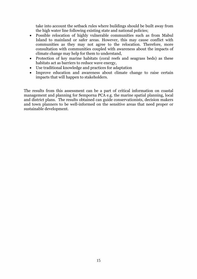
5. Local Early Action Planning (LEAP) for Selakan Island 5.1 Method and Materials The Selakan Island CIVAT ranking is medium in comparison to other highly vulnerable communities. However, the adaptation measures determined by CIVAT to those identified using LEAP for Selakan are closely linked. Therefore, the LEAP was used as a complementary tool to CIVAT in determining community-based adaptation options. The LEAP guide assessed the vulnerability in Selakan Island. This provides an example of community-based approach in climate change vulnerability assessment. The guide was selected for use because its structure primarily focuses on community-based approach seeking community-based adaptation solutions which are consistent with Sabah Parks’ current engagement in managing and increasing awareness on the usage of multi zones with the Parks’ communities. The LEAP involved implementation of four steps conducted by WWF-Malaysia, Universiti Malaysia Sabah, Sabah Parks and Marine Conservation Society/Semporna Islands Project (MCS/SIP). Each of the LEAP steps was undertaken over a series of meetings, surveys and workshops between July 2013 and September 2014. Each LEAP step was complemented with worksheets prepared in the guide and discussed and filled during the meetings, surveys and workshops (Appendices 9.4 & 9.5 for list of worksheet results). The steps and respective activities were:
5.1.1. Getting organized for CCA planning The implementation of the assessment emanate from the Malaysia’s Climate Change Team that was formed during the 2nd Regional CCA Training conducted by USCTI in early 2012. The pool of trainers composed of 1 Universiti Malaysia Sabah staff, WWF-Malaysia staff and Sabah Parks staffs.
A series of meetings on July 2013 (Figure 4) to discuss among the organisation of the trainers on the collaboration and familiarisation of the assessment were conducted to ensure approval and smooth implementation of the assessment in the coming 1-year period.
A 1-day workshop (Figure 5) facilitated by WWF-Malaysia and Universiti Malaysia Sabah was conducted on 11 September 2013 in Semporna with participation of government agencies including Semporna District Office, Sabah Parks, Sabah Wildlife Department; environmental
Figure 42: Meeting with Sabah Parks Semporna
Figure 4: Group presentation on Selakan Island
© WWF-Malaysia / Gavin Jolis
Figure 53: Group presentation on Selakan Island
Figure 4: Stakeholders meeting
Figure 5: Discussion outcomes on Selakan Island
© Universiti Malaysia Sabah
17
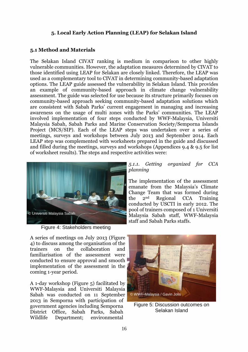
organizations MCS/SIP, and the CTI – Sabah Branch. The workshop included group discussions with pictorial maps and references to Selakan Island. The result of the workshop was the formation of the Selakan CCA Planning Team to support adaptation planning and collection of background information on the Selakan community and identification of priority concerns that can provide an entry point for adaptation planning. The workshop included an orientation on climate change basics in the form of a presentation that provided information on the local climate in Malaysia and the causes and the imminent effects of climate change. The step ended with a checklist of the step and the review of the LEAP outline with the CCA Planning Team completed. 5.1.2 Telling your climate story
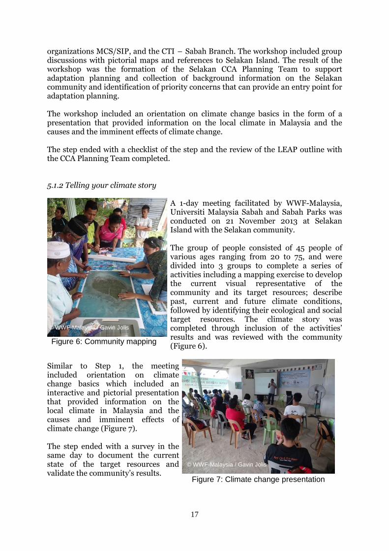
A 1-day meeting facilitated by WWF-Malaysia, Universiti Malaysia Sabah and Sabah Parks was conducted on 21 November 2013 at Selakan Island with the Selakan community. The group of people consisted of 45 people of various ages ranging from 20 to 75, and were divided into 3 groups to complete a series of activities including a mapping exercise to develop the current visual representative of the community and its target resources; describe past, current and future climate conditions, followed by identifying their ecological and social target resources. The climate story was completed through inclusion of the activities’ results and was reviewed with the community (Figure 6).
Similar to Step 1, the meeting included orientation on climate change basics which included an interactive and pictorial presentation that provided information on the local climate in Malaysia and the causes and imminent effects of climate change (Figure 7). The step ended with a survey in the same day to document the current state of the target resources and validate the community’s results. © WWF-Malaysia / Gavin Jolis
Figure 6: Community mapping
Figure 7: Climate change presentation
© WWF-Malaysia / Gavin Jolis
© WWF-Malaysia / Gavin Jolis
18
5.1.3 Conducting a vulnerability assessment A series of discussions among the Selakan CCA Planning Team were conducted to rate the vulnerability of all six target resources to either low, medium or high. The target resources were:
• Conditions and trends of target resources described and non-climatic threats and root causes responsible for these trends determined
• Exposure of target resources to climate threats described
• Sensitivity to target resources to climate threats described
• Potential impacts to target resources were assessed through the exposure-sensitivity matrix (Table 10).
Table 10: Potential impact as a function of sensitivity and exposure Potential Impact Sensitivity
Exposure L M H
L L L M M L M H H M H H
• Adaptive capacity of target resources and community described
• The vulnerability of the target resources were assessed through the vulnerable rating matrix (Table 11).
Table 11: Vulnerability as a function of potential impact and adaptive capacity Vulnerability Adaptive Capacity
Potential Impact
L M H L M L L M H M L H H H M
A 1-day meeting facilitated by WWF-Malaysia and Universiti Malaysia Sabah was conducted on 29 September 2014 at Semporna with participation of the Selakan community for their further inputs.
19
5.1.4 Developing your local early action plan
Similarly to vulnerability ratings, a series of discussion in October 2014 among the Selakan CCA Planning Team were conducted to identify adaptation options for each target resource. The effectiveness, cost involved, benefits received and feasibility of each adaptation option for each target resource were accessed and prioritised. A monitoring and evaluation approach was also developed to demonstrate the community’s progress toward
implementing its priority adaptation options.
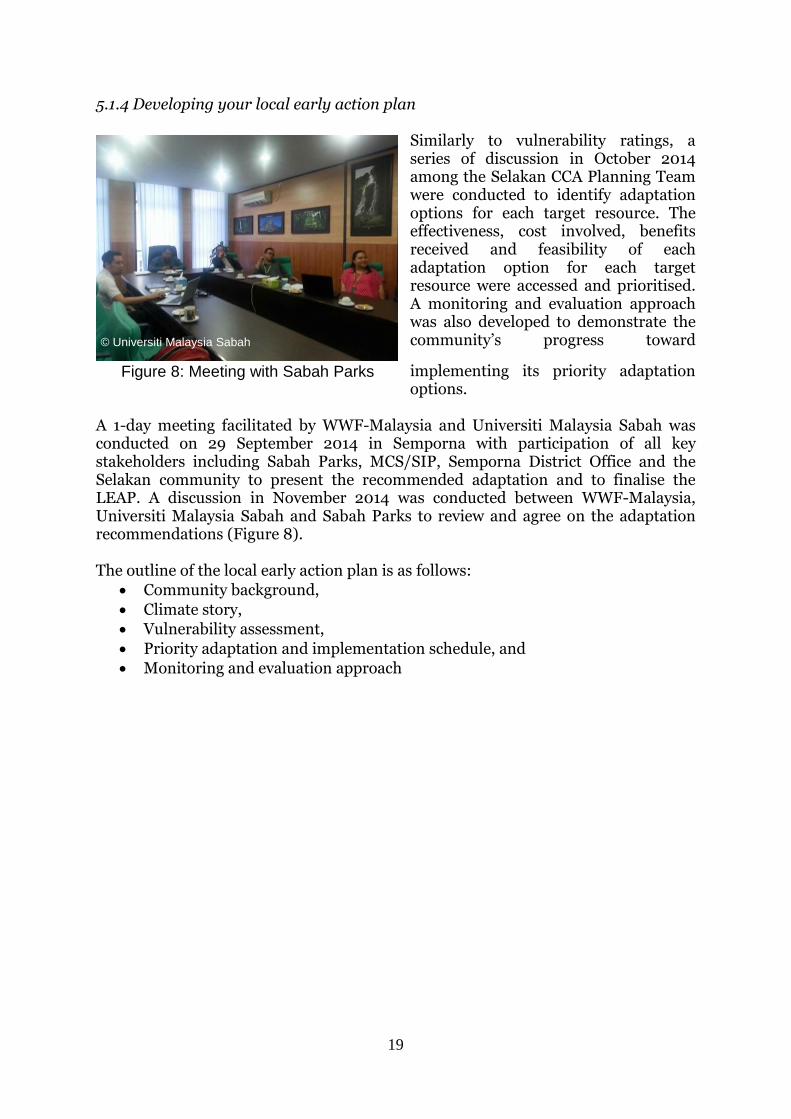
A 1-day meeting facilitated by WWF-Malaysia and Universiti Malaysia Sabah was conducted on 29 September 2014 in Semporna with participation of all key stakeholders including Sabah Parks, MCS/SIP, Semporna District Office and the Selakan community to present the recommended adaptation and to finalise the LEAP. A discussion in November 2014 was conducted between WWF-Malaysia, Universiti Malaysia Sabah and Sabah Parks to review and agree on the adaptation recommendations (Figure 8). The outline of the local early action plan is as follows:
Community background,
Climate story,
Vulnerability assessment,
Priority adaptation and implementation schedule, and
Monitoring and evaluation approach
Figure 8: Meeting with Sabah Parks
© Universiti Malaysia Sabah
20
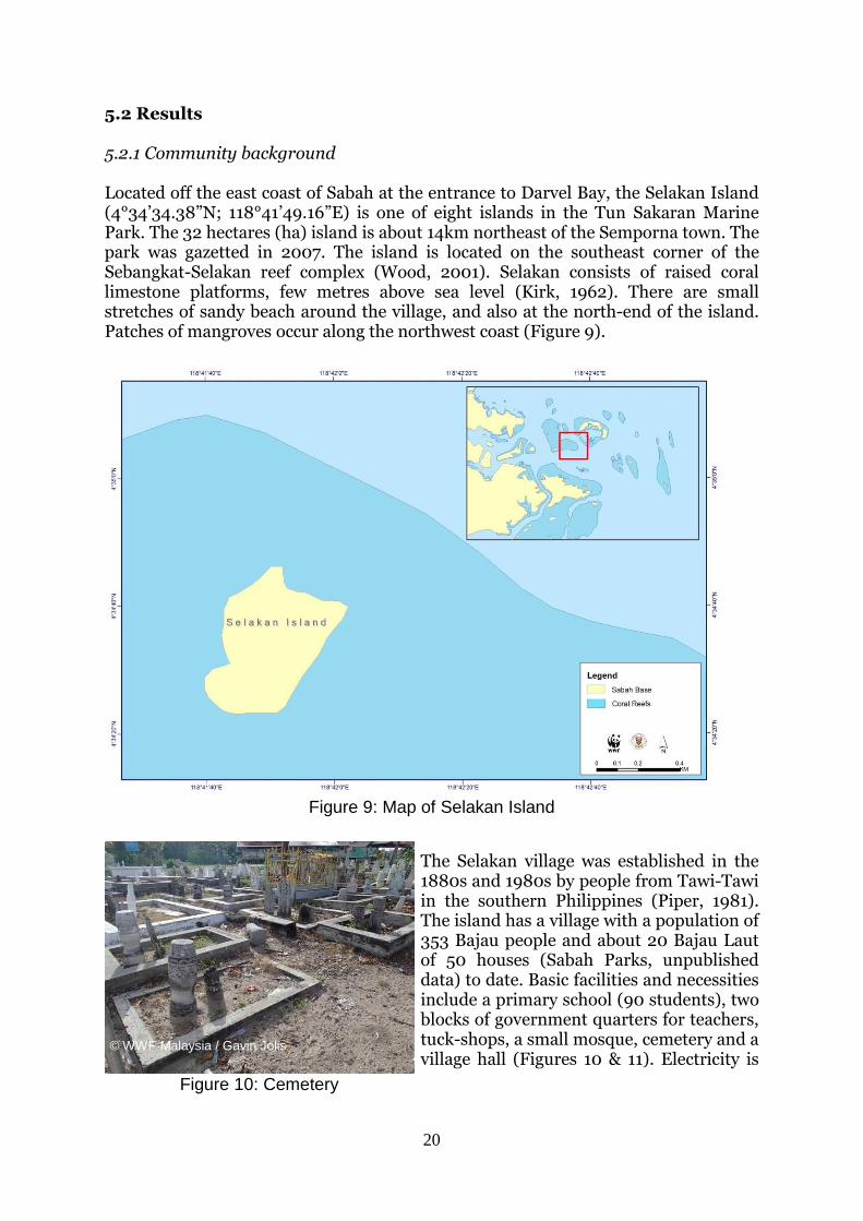
5.2 Results 5.2.1 Community background Located off the east coast of Sabah at the entrance to Darvel Bay, the Selakan Island (4°34’34.38”N; 118°41’49.16”E) is one of eight islands in the Tun Sakaran Marine Park. The 32 hectares (ha) island is about 14km northeast of the Semporna town. The park was gazetted in 2007. The island is located on the southeast corner of the Sebangkat-Selakan reef complex (Wood, 2001). Selakan consists of raised coral limestone platforms, few metres above sea level (Kirk, 1962). There are small stretches of sandy beach around the village, and also at the north-end of the island. Patches of mangroves occur along the northwest coast (Figure 9).
Figure 9: Map of Selakan Island
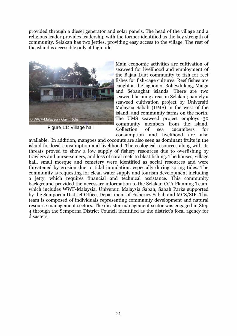
The Selakan village was established in the 1880s and 1980s by people from Tawi-Tawi in the southern Philippines (Piper, 1981). The island has a village with a population of 353 Bajau people and about 20 Bajau Laut of 50 houses (Sabah Parks, unpublished data) to date. Basic facilities and necessities include a primary school (90 students), two blocks of government quarters for teachers, tuck-shops, a small mosque, cemetery and a village hall (Figures 10 & 11). Electricity is
Figure 8: Cemetery
© WWF-Malaysia / Gavin Jolis
Figure 10: Cemetery
21
provided through a diesel generator and solar panels. The head of the village and a religious leader provides leadership with the former identified as the key strength of community. Selakan has two jetties, providing easy access to the village. The rest of the island is accessible only at high tide.
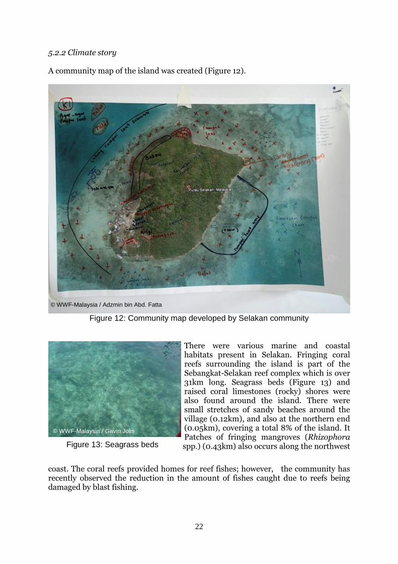
Main economic activities are cultivation of seaweed for livelihood and employment of the Bajau Laut community to fish for reef fishes for fish-cage cultures. Reef fishes are caught at the lagoon of Boheydulang, Maiga and Sebangkat islands. There are two seaweed farming areas in Selakan; namely a seaweed cultivation project by Universiti Malaysia Sabah (UMS) in the west of the island, and community farms on the north. The UMS seaweed project employs 30 community members from the island. Collection of sea cucumbers for consumption and livelihood are also
available. In addition, mangoes and coconuts are also seen as dominant fruits in the island for local consumption and livelihood. The ecological resources along with its threats proved to show a low supply of fishery resources due to overfishing by trawlers and purse-seiners, and loss of coral reefs to blast fishing. The houses, village hall, small mosque and cemetery were identified as social resources and were threatened by erosion due to tidal inundation, especially during spring tides. The community is requesting for clean water supply and tourism development including a jetty, which requires financial and technical assistance. This community background provided the necessary information to the Selakan CCA Planning Team, which includes WWF-Malaysia, Universiti Malaysia Sabah, Sabah Parks supported by the Semporna District Office, Department of Fisheries Sabah and MCS/SIP. This team is composed of individuals representing community development and natural resource management sectors. The disaster management sector was engaged in Step 4 through the Semporna District Council identified as the district’s focal agency for disasters.
Figure 97: Village hall © WWF-Malaysia / Gavin Jolis
Figure 11: Village hall
22
5.2.2 Climate story A community map of the island was created (Figure 12).
Figure 12: Community map developed by Selakan community
There were various marine and coastal habitats present in Selakan. Fringing coral reefs surrounding the island is part of the Sebangkat-Selakan reef complex which is over 31km long. Seagrass beds (Figure 13) and raised coral limestones (rocky) shores were also found around the island. There were small stretches of sandy beaches around the village (0.12km), and also at the northern end (0.05km), covering a total 8% of the island. It Patches of fringing mangroves (Rhizophora spp.) (0.43km) also occurs along the northwest
coast. The coral reefs provided homes for reef fishes; however, the community has recently observed the reduction in the amount of fishes caught due to reefs being damaged by blast fishing.
Figure 10: Seagrass beds
Figure 13: Seagrass beds
© WWF-Malaysia / Gavin Jolis
© WWF-Malaysia / Adzmin bin Abd. Fatta
23
The establishment of the Marine Protected Area has limited their fishing grounds. They have to bear high cost and more time for further offshore fishing operations. Most of the community participants in the meeting at Selakan agreed that marine resources are depleting and the catch sizes have decreased since the 80’s due to overfishing and presence of foreign fishers who practice blast fishing. Alternative methods have been introduced by the local government to improve the coastal community livelihood. The seaweed cultivation
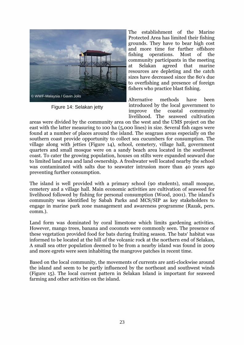
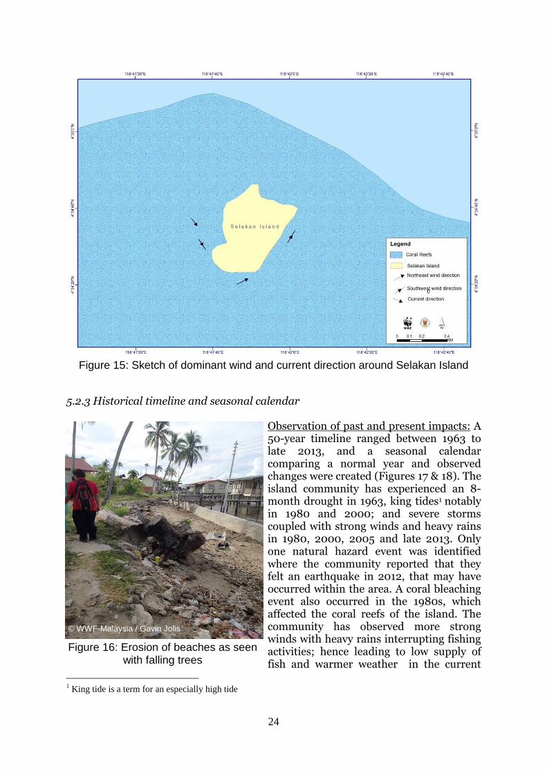
areas were divided by the community area on the west and the UMS project on the east with the latter measuring to 100 ha (5,000 lines) in size. Several fish cages were found at a number of places around the island. The seagrass areas especially on the southern coast provide opportunity to collect sea cucumbers for consumption. The village along with jetties (Figure 14), school, cemetery, village hall, government quarters and small mosque were on a sandy beach area located in the southwest coast. To cater the growing population, houses on stilts were expanded seaward due to limited land area and land ownership. A freshwater well located nearby the school was contaminated with salts due to seawater intrusion more than 40 years ago preventing further consumption. The island is well provided with a primary school (90 students), small mosque, cemetery and a village hall. Main economic activities are cultivation of seaweed for livelihood followed by fishing for personal consumption (Wood, 2001). The island’s community was identified by Sabah Parks and MCS/SIP as key stakeholders to engage in marine park zone management and awareness programme (Razak, pers. comm.). Land form was dominated by coral limestone which limits gardening activities. However, mango trees, banana and coconuts were commonly seen. The presence of these vegetation provided food for bats during fruiting season. The bats’ habitat was informed to be located at the hill of the volcanic rock at the northern end of Selakan, A small sea otter population deemed to be from a nearby island was found in 2009 and more egrets were seen inhabiting the mangrove patches in recent time. Based on the local community, the movements of currents are anti-clockwise around the island and seem to be partly influenced by the northeast and southwest winds (Figure 15). The local current pattern in Selakan Island is important for seaweed farming and other activities on the island.
Figure 11: Jetty
© WWF-Malaysia / Gavin Jolis
Figure 14: Selakan jetty
24
Figure 15: Sketch of dominant wind and current direction around Selakan Island
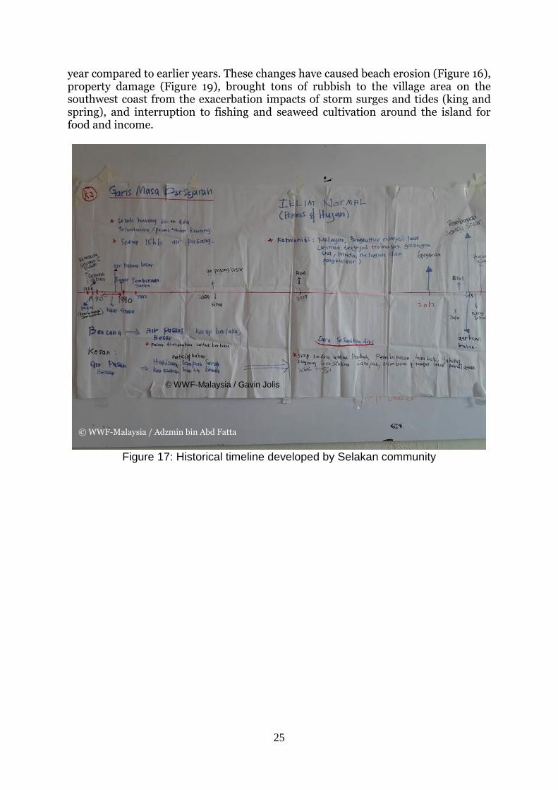
5.2.3 Historical timeline and seasonal calendar Observation of past and present impacts: A 50-year timeline ranged between 1963 to late 2013, and a seasonal calendar comparing a normal year and observed changes were created (Figures 17 & 18). The island community has experienced an 8-month drought in 1963, king tides1 notably in 1980 and 2000; and severe storms coupled with strong winds and heavy rains in 1980, 2000, 2005 and late 2013. Only one natural hazard event was identified where the community reported that they felt an earthquake in 2012, that may have occurred within the area. A coral bleaching event also occurred in the 1980s, which affected the coral reefs of the island. The community has observed more strong winds with heavy rains interrupting fishing activities; hence leading to low supply of fish and warmer weather in the current
1 King tide is a term for an especially high tide
Figure 16: Erosion of beaches as seen with falling trees
© WWF-Malaysia / Gavin Jolis
25
year compared to earlier years. These changes have caused beach erosion (Figure 16), property damage (Figure 19), brought tons of rubbish to the village area on the southwest coast from the exacerbation impacts of storm surges and tides (king and spring), and interruption to fishing and seaweed cultivation around the island for food and income.
Figure 17: Historical timeline developed by Selakan community
© WWF-Malaysia / Gavin Jolis
© WWF-Malaysia / Adzmin bin Abd Fatta
26
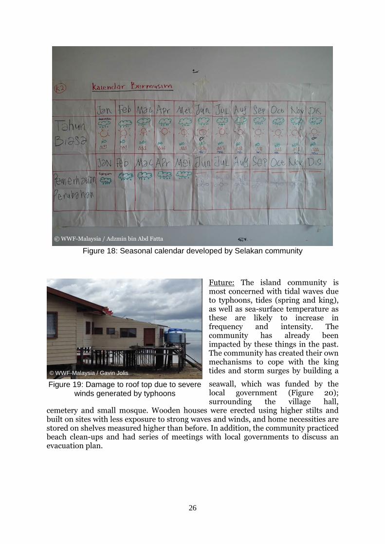
Figure 18: Seasonal calendar developed by Selakan community
Future: The island community is most concerned with tidal waves due to typhoons, tides (spring and king), as well as sea-surface temperature as these are likely to increase in frequency and intensity. The community has already been impacted by these things in the past. The community has created their own mechanisms to cope with the king tides and storm surges by building a
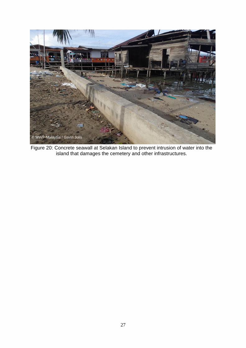
seawall, which was funded by the local government (Figure 20); surrounding the village hall,
cemetery and small mosque. Wooden houses were erected using higher stilts and built on sites with less exposure to strong waves and winds, and home necessities are stored on shelves measured higher than before. In addition, the community practiced beach clean-ups and had series of meetings with local governments to discuss an evacuation plan.
© WWF-Malaysia / Gavin Jolis
Figure 19: Damage to roof top due to severe winds generated by typhoons
© WWF-Malaysia / Adzmin bin Abd Fatta
27
Figure 20: Concrete seawall at Selakan Island to prevent intrusion of water into the
island that damages the cemetery and other infrastructures.
© WWF-Malaysia / Gavin Jolis
28
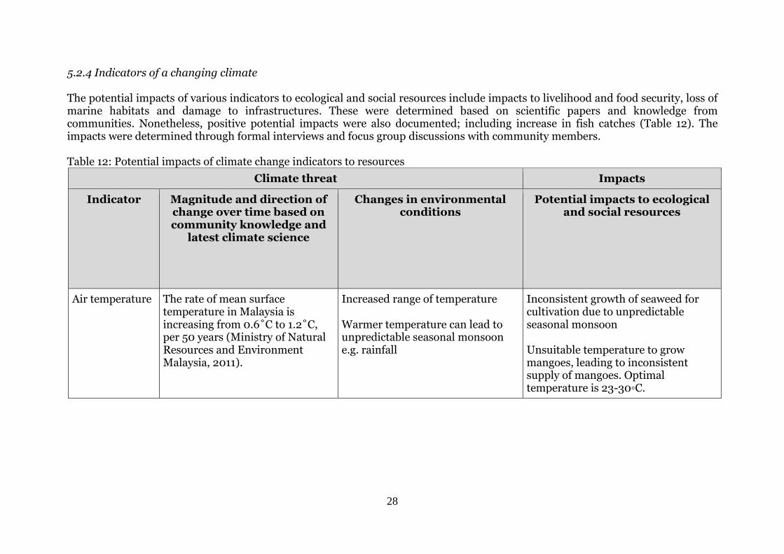
5.2.4 Indicators of a changing climate The potential impacts of various indicators to ecological and social resources include impacts to livelihood and food security, loss of marine habitats and damage to infrastructures. These were determined based on scientific papers and knowledge from communities. Nonetheless, positive potential impacts were also documented; including increase in fish catches (Table 12). The impacts were determined through formal interviews and focus group discussions with community members. Table 12: Potential impacts of climate change indicators to resources
Climate threat Impacts
Indicator Magnitude and direction of change over time based on community knowledge and
latest climate science
Changes in environmental conditions
Potential impacts to ecological and social resources
Air temperature The rate of mean surface temperature in Malaysia is increasing from 0.6˚C to 1.2˚C, per 50 years (Ministry of Natural Resources and Environment Malaysia, 2011).
Increased range of temperature Warmer temperature can lead to unpredictable seasonal monsoon e.g. rainfall
Inconsistent growth of seaweed for cultivation due to unpredictable seasonal monsoon Unsuitable temperature to grow mangoes, leading to inconsistent supply of mangoes. Optimal temperature is 23-30◦C.
29
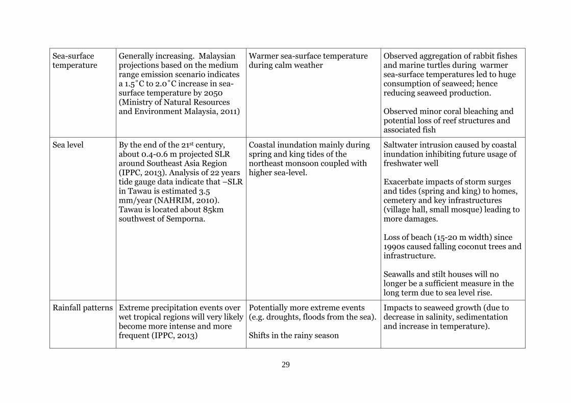
Sea-surface temperature
Generally increasing. Malaysian projections based on the medium range emission scenario indicates a 1.5˚C to 2.0˚C increase in sea-surface temperature by 2050 (Ministry of Natural Resources and Environment Malaysia, 2011)
Warmer sea-surface temperature during calm weather
Observed aggregation of rabbit fishes and marine turtles during warmer sea-surface temperatures led to huge consumption of seaweed; hence reducing seaweed production. Observed minor coral bleaching and potential loss of reef structures and associated fish
Sea level By the end of the 21st century, about 0.4-0.6 m projected SLR around Southeast Asia Region (IPPC, 2013). Analysis of 22 years tide gauge data indicate that –SLR in Tawau is estimated 3.5 mm/year (NAHRIM, 2010). Tawau is located about 85km southwest of Semporna.
Coastal inundation mainly during spring and king tides of the northeast monsoon coupled with higher sea-level.
Saltwater intrusion caused by coastal inundation inhibiting future usage of freshwater well Exacerbate impacts of storm surges and tides (spring and king) to homes, cemetery and key infrastructures (village hall, small mosque) leading to more damages. Loss of beach (15-20 m width) since 1990s caused falling coconut trees and infrastructure. Seawalls and stilt houses will no longer be a sufficient measure in the long term due to sea level rise.
Rainfall patterns Extreme precipitation events over wet tropical regions will very likely become more intense and more frequent (IPPC, 2013)
Potentially more extreme events (e.g. droughts, floods from the sea). Shifts in the rainy season
Impacts to seaweed growth (due to decrease in salinity, sedimentation and increase in temperature).
30
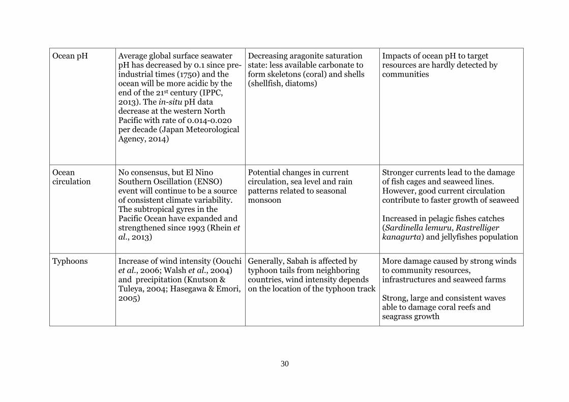
Ocean pH Average global surface seawater pH has decreased by 0.1 since pre-industrial times (1750) and the ocean will be more acidic by the end of the 21st century (IPPC, 2013). The in-situ pH data decrease at the western North Pacific with rate of 0.014-0.020 per decade (Japan Meteorological Agency, 2014)
Decreasing aragonite saturation state: less available carbonate to form skeletons (coral) and shells (shellfish, diatoms)
Impacts of ocean pH to target resources are hardly detected by communities
Ocean circulation
No consensus, but El Nino Southern Oscillation (ENSO) event will continue to be a source of consistent climate variability. The subtropical gyres in the Pacific Ocean have expanded and strengthened since 1993 (Rhein et al., 2013)
Potential changes in current circulation, sea level and rain patterns related to seasonal monsoon
Stronger currents lead to the damage of fish cages and seaweed lines. However, good current circulation contribute to faster growth of seaweed Increased in pelagic fishes catches (Sardinella lemuru, Rastrelliger kanagurta) and jellyfishes population
Typhoons Increase of wind intensity (Oouchi et al., 2006; Walsh et al., 2004) and precipitation (Knutson & Tuleya, 2004; Hasegawa & Emori, 2005)
Generally, Sabah is affected by typhoon tails from neighboring countries, wind intensity depends on the location of the typhoon track
More damage caused by strong winds to community resources, infrastructures and seaweed farms Strong, large and consistent waves able to damage coral reefs and seagrass growth
31
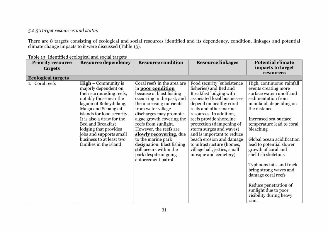
5.2.5 Target resources and status There are 8 targets consisting of ecological and social resources identified and its dependency, condition, linkages and potential climate change impacts to it were discussed (Table 13). Table 13: Identified ecological and social targets
Priority resource
targets
Resource dependency Resource condition Resource linkages Potential climate impacts to target
resources Ecological targets
1. Coral reefs High – Community is majorly dependent on their surrounding reefs; notably those near the lagoon of Boheydulang, Maiga and Sebangkat islands for food security. It is also a draw for the Bed and Breakfast lodging that provides jobs and supports small business to at least two families in the island
Coral reefs in the area are in poor condition because of blast fishing occurring in the past, and the increasing nutrients from water village discharges may promote algae growth covering the reefs from sunlight. However, the reefs are slowly recovering, due to the marine park designation. Blast fishing still occurs within the park despite ongoing enforcement patrol
Food security (subsistence fisheries) and Bed and Breakfast lodging with associated local businesses depend on healthy coral reefs and other marine resources. In addition, reefs provide shoreline protection (dampening of storm surges and waves) and is important to reduce beach erosion and damage to infrastructure (homes, village hall, jetties, small mosque and cemetery)
High, continuous rainfall events creating more surface water runoff and sedimentation from mainland, depending on the distance Increased sea-surface temperature lead to coral bleaching Global ocean acidification lead to potential slower growth of coral and shellfish skeletons Typhoons tails and track bring strong waves and damage coral reefs Reduce penetration of sunlight due to poor visibility during heavy rain.
32
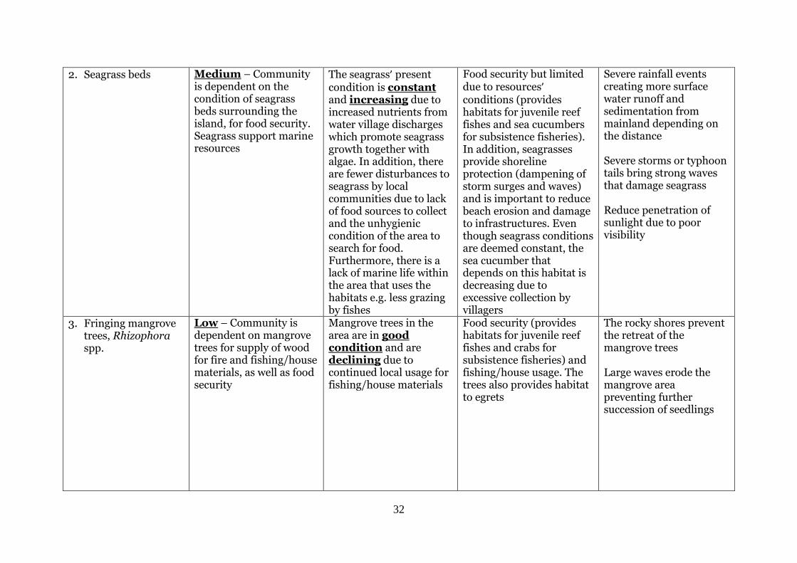
2. Seagrass beds Medium – Community is dependent on the condition of seagrass beds surrounding the island, for food security. Seagrass support marine resources
The seagrass’ present condition is constant and increasing due to increased nutrients from water village discharges which promote seagrass growth together with algae. In addition, there are fewer disturbances to seagrass by local communities due to lack of food sources to collect and the unhygienic condition of the area to search for food. Furthermore, there is a lack of marine life within the area that uses the habitats e.g. less grazing by fishes
Food security but limited due to resources’ conditions (provides habitats for juvenile reef fishes and sea cucumbers for subsistence fisheries). In addition, seagrasses provide shoreline protection (dampening of storm surges and waves) and is important to reduce beach erosion and damage to infrastructures. Even though seagrass conditions are deemed constant, the sea cucumber that depends on this habitat is decreasing due to excessive collection by villagers
Severe rainfall events creating more surface water runoff and sedimentation from mainland depending on the distance Severe storms or typhoon tails bring strong waves that damage seagrass Reduce penetration of sunlight due to poor visibility
3. Fringing mangrove trees, Rhizophora spp.
Low – Community is dependent on mangrove trees for supply of wood for fire and fishing/house materials, as well as food security
Mangrove trees in the area are in good condition and are declining due to continued local usage for fishing/house materials
Food security (provides habitats for juvenile reef fishes and crabs for subsistence fisheries) and fishing/house usage. The trees also provides habitat to egrets
The rocky shores prevent the retreat of the mangrove trees Large waves erode the mangrove area preventing further succession of seedlings
33
Social targets
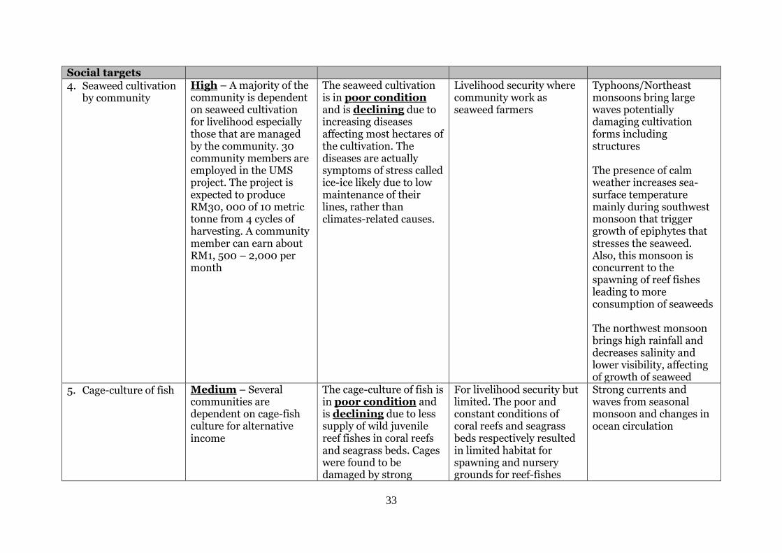
4. Seaweed cultivation by community
High – A majority of the community is dependent on seaweed cultivation for livelihood especially those that are managed by the community. 30 community members are employed in the UMS project. The project is expected to produce RM30, 000 of 10 metric tonne from 4 cycles of harvesting. A community member can earn about RM1, 500 – 2,000 per month
The seaweed cultivation is in poor condition and is declining due to increasing diseases affecting most hectares of the cultivation. The diseases are actually symptoms of stress called ice-ice likely due to low maintenance of their lines, rather than climates-related causes.
Livelihood security where community work as seaweed farmers
Typhoons/Northeast monsoons bring large waves potentially damaging cultivation forms including structures The presence of calm weather increases sea-surface temperature mainly during southwest monsoon that trigger growth of epiphytes that stresses the seaweed. Also, this monsoon is concurrent to the spawning of reef fishes leading to more consumption of seaweeds The northwest monsoon brings high rainfall and decreases salinity and lower visibility, affecting of growth of seaweed
5. Cage-culture of fish Medium – Several communities are dependent on cage-fish culture for alternative income
The cage-culture of fish is in poor condition and is declining due to less supply of wild juvenile reef fishes in coral reefs and seagrass beds. Cages were found to be damaged by strong
For livelihood security but limited. The poor and constant conditions of coral reefs and seagrass beds respectively resulted in limited habitat for spawning and nursery grounds for reef-fishes
Strong currents and waves from seasonal monsoon and changes in ocean circulation
34
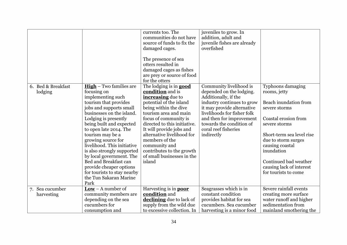
currents too. The communities do not have source of funds to fix the damaged cages. The presence of sea otters resulted in damaged cages as fishes are prey or source of food for the otters
juveniles to grow. In addition, adult and juvenile fishes are already overfished
6. Bed & Breakfast lodging
High – Two families are focusing on implementing such tourism that provides jobs and supports small businesses on the island. Lodging is presently being built and expected to open late 2014. The tourism may be a growing source for livelihood. This initiative is also strongly supported by local government. The Bed and Breakfast can provide cheaper options for tourists to stay nearby the Tun Sakaran Marine Park
The lodging is in good condition and is increasing due to potential of the island being within the dive tourism area and main focus of community is directed to this initiative. It will provide jobs and alternative livelihood for members of the community and contributes to the growth of small businesses in the island
Community livelihood is depended on the lodging. Additionally, if the industry continues to grow it may provide alternative livelihoods for fisher folk and then for improvement towards the condition of coral reef fisheries indirectly
Typhoons damaging rooms, jetty Beach inundation from severe storms Coastal erosion from severe storms Short-term sea level rise due to storm surges causing coastal inundation Continued bad weather causing lack of interest for tourists to come
7. Sea cucumber harvesting
Low – A number of community members are depending on the sea cucumbers for consumption and
Harvesting is in poor condition and declining due to lack of supply from the wild due to excessive collection. In
Seagrasses which is in constant condition provides habitat for sea cucumbers. Sea cucumber harvesting is a minor food
Severe rainfall events creating more surface water runoff and higher sedimentation from mainland smothering the
35
alternative livelihood addition, pollution from human e.g. rubbish around seagrasses resulted in less space for sea cucumbers to occupy.
security and alternative livelihood.
sea cucumbers. Strong currents and waves may disrupt the distribution of juvenile sea cucumbers
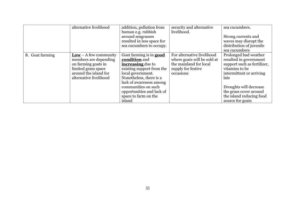
8. Goat farming Low – A few community members are depending on farming goats in limited grass space around the island for alternative livelihood
Goat farming is in good condition and increasing due to existing support from the local government. Nonetheless, there is a lack of awareness among communities on such opportunities and lack of space to farm on the island
For alternative livelihood where goats will be sold at the mainland for local supply for festive occasions
Prolonged bad weather resulted in government support such as fertilizer, vitamins to be intermittent or arriving late Droughts will decrease the grass cover around the island reducing food source for goats
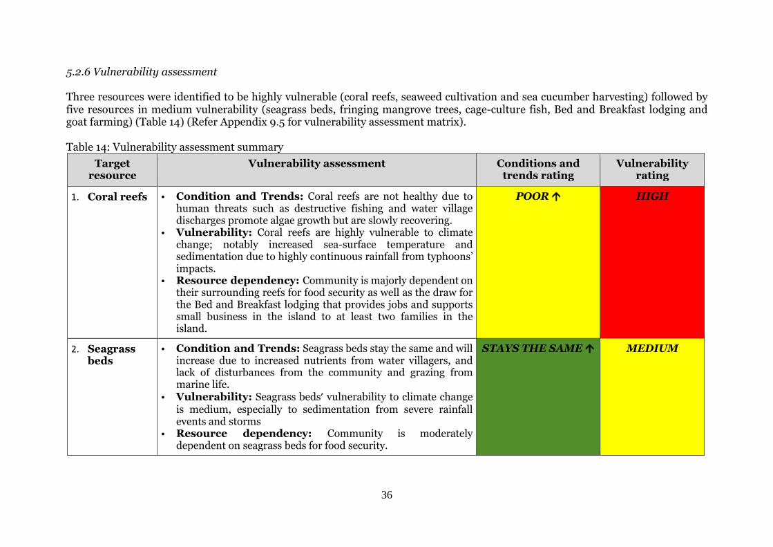
36
5.2.6 Vulnerability assessment Three resources were identified to be highly vulnerable (coral reefs, seaweed cultivation and sea cucumber harvesting) followed by five resources in medium vulnerability (seagrass beds, fringing mangrove trees, cage-culture fish, Bed and Breakfast lodging and goat farming) (Table 14) (Refer Appendix 9.5 for vulnerability assessment matrix). Table 14: Vulnerability assessment summary
Target resource
Vulnerability assessment Conditions and trends rating
Vulnerability rating
1. Coral reefs • Condition and Trends: Coral reefs are not healthy due to human threats such as destructive fishing and water village discharges promote algae growth but are slowly recovering.
• Vulnerability: Coral reefs are highly vulnerable to climate change; notably increased sea-surface temperature and sedimentation due to highly continuous rainfall from typhoons’ impacts.
• Resource dependency: Community is majorly dependent on their surrounding reefs for food security as well as the draw for the Bed and Breakfast lodging that provides jobs and supports small business in the island to at least two families in the island.
POOR HIGH
2. Seagrass beds
• Condition and Trends: Seagrass beds stay the same and will increase due to increased nutrients from water villagers, and lack of disturbances from the community and grazing from marine life.
• Vulnerability: Seagrass beds’ vulnerability to climate change is medium, especially to sedimentation from severe rainfall events and storms
• Resource dependency: Community is moderately dependent on seagrass beds for food security.
STAYS THE SAME MEDIUM
© Sabah Parks
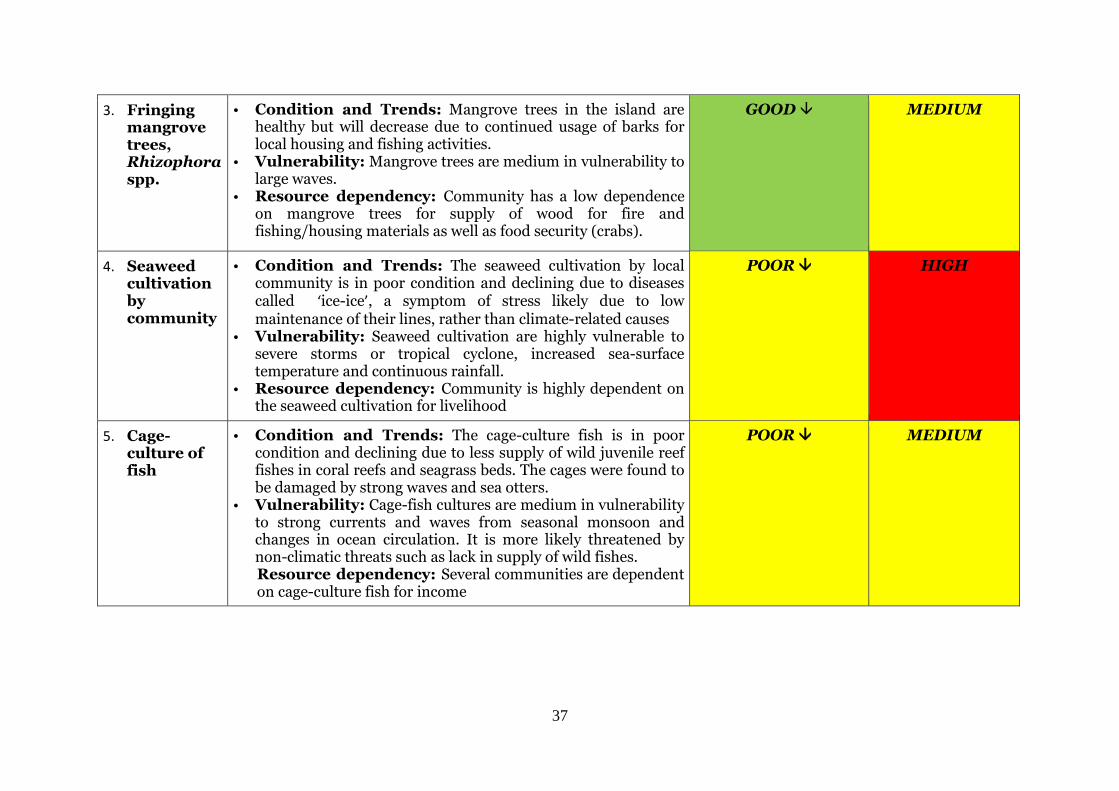
37
3. Fringing mangrove trees, Rhizophora spp.
• Condition and Trends: Mangrove trees in the island are healthy but will decrease due to continued usage of barks for local housing and fishing activities.
• Vulnerability: Mangrove trees are medium in vulnerability to large waves.
• Resource dependency: Community has a low dependence on mangrove trees for supply of wood for fire and fishing/housing materials as well as food security (crabs).
GOOD MEDIUM
4. Seaweed cultivation by community
• Condition and Trends: The seaweed cultivation by local community is in poor condition and declining due to diseases called ‘ice-ice’, a symptom of stress likely due to low maintenance of their lines, rather than climate-related causes
• Vulnerability: Seaweed cultivation are highly vulnerable to severe storms or tropical cyclone, increased sea-surface temperature and continuous rainfall.
• Resource dependency: Community is highly dependent on the seaweed cultivation for livelihood
POOR HIGH
5. Cage-culture of fish
• Condition and Trends: The cage-culture fish is in poor condition and declining due to less supply of wild juvenile reef fishes in coral reefs and seagrass beds. The cages were found to be damaged by strong waves and sea otters.
• Vulnerability: Cage-fish cultures are medium in vulnerability to strong currents and waves from seasonal monsoon and changes in ocean circulation. It is more likely threatened by non-climatic threats such as lack in supply of wild fishes. Resource dependency: Several communities are dependent on cage-culture fish for income
POOR MEDIUM
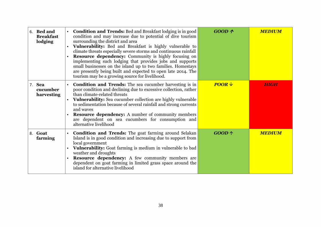
38
6. Bed and Breakfast lodging
• Condition and Trends: Bed and Breakfast lodging is in good condition and may increase due to potential of dive tourism surrounding the district and area
• Vulnerability: Bed and Breakfast is highly vulnerable to climate threats especially severe storms and continuous rainfall
• Resource dependency: Community is highly focusing on implementing such lodging that provides jobs and supports small businesses on the island up to two families. Homestays are presently being built and expected to open late 2014. The tourism may be a growing source for livelihood.
GOOD MEDIUM
7. Sea cucumber harvesting
• Condition and Trends: The sea cucumber harvesting is in poor condition and declining due to excessive collection, rather than climate-related threats
• Vulnerability: Sea cucumber collection are highly vulnerable to sedimentation because of several rainfall and strong currents and waves
• Resource dependency: A number of community members are dependent on sea cucumbers for consumption and alternative livelihood
POOR HIGH
8. Goat farming
• Condition and Trends: The goat farming around Selakan Island is in good condition and increasing due to support from local government
• Vulnerability: Goat farming is medium in vulnerable to bad weather and droughts
• Resource dependency: A few community members are dependent on goat farming in limited grass space around the island for alternative livelihood
GOOD MEDIUM
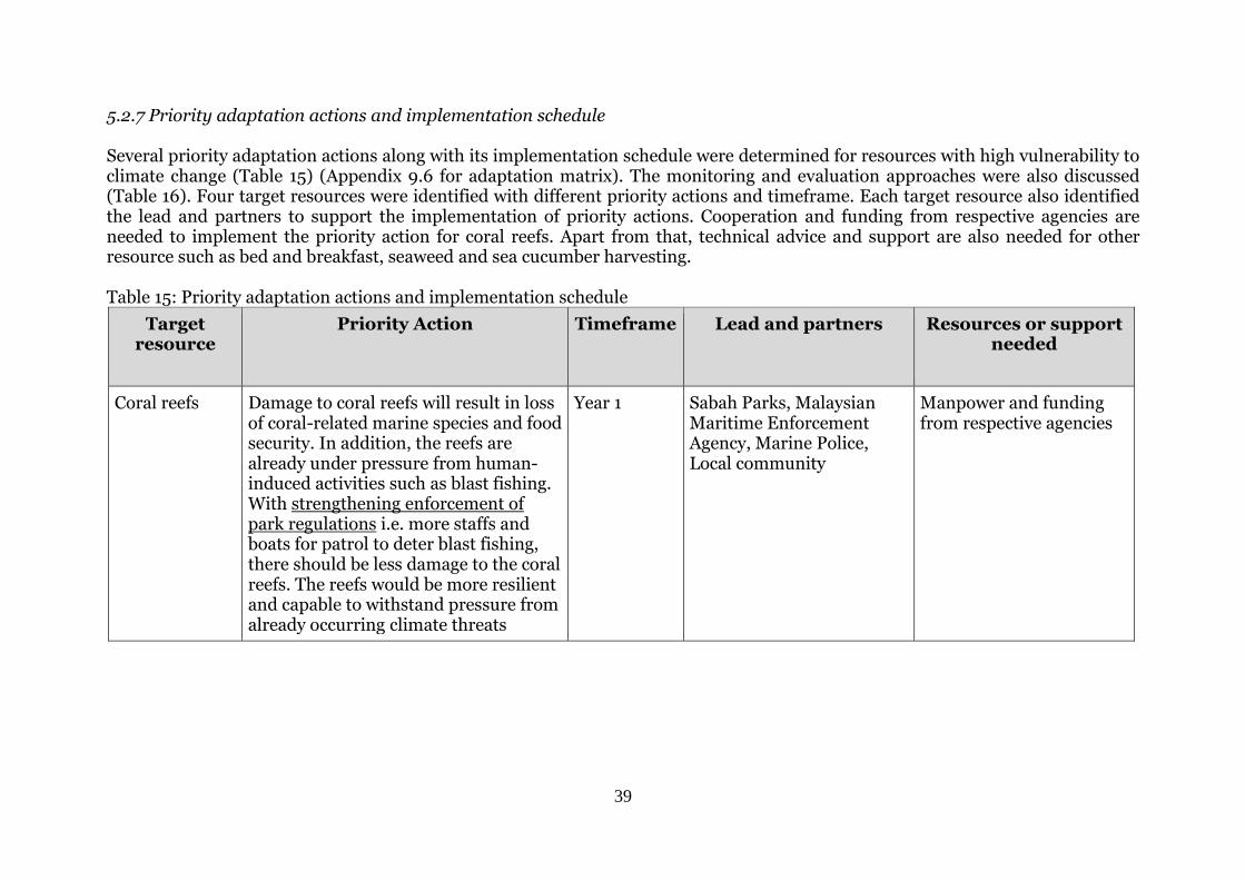
39
5.2.7 Priority adaptation actions and implementation schedule Several priority adaptation actions along with its implementation schedule were determined for resources with high vulnerability to climate change (Table 15) (Appendix 9.6 for adaptation matrix). The monitoring and evaluation approaches were also discussed (Table 16). Four target resources were identified with different priority actions and timeframe. Each target resource also identified the lead and partners to support the implementation of priority actions. Cooperation and funding from respective agencies are needed to implement the priority action for coral reefs. Apart from that, technical advice and support are also needed for other resource such as bed and breakfast, seaweed and sea cucumber harvesting. Table 15: Priority adaptation actions and implementation schedule
Target resource
Priority Action Timeframe Lead and partners Resources or support needed
Coral reefs Damage to coral reefs will result in loss of coral-related marine species and food security. In addition, the reefs are already under pressure from human-induced activities such as blast fishing. With strengthening enforcement of park regulations i.e. more staffs and boats for patrol to deter blast fishing, there should be less damage to the coral reefs. The reefs would be more resilient and capable to withstand pressure from already occurring climate threats
Year 1 Sabah Parks, Malaysian Maritime Enforcement Agency, Marine Police, Local community
Manpower and funding from respective agencies
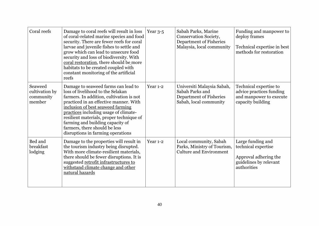
40
Coral reefs Damage to coral reefs will result in loss of coral-related marine species and food security. There are fewer reefs for coral larvae and juvenile fishes to settle and grow which can lead to unsecure food security and loss of biodiversity. With coral restoration, there should be more habitats to be created coupled with constant monitoring of the artificial reefs
Year 3-5 Sabah Parks, Marine Conservation Society, Department of Fisheries Malaysia, local community
Funding and manpower to deploy frames Technical expertise in best methods for restoration
Seaweed cultivation by community member
Damage to seaweed farms can lead to loss of livelihood to the Selakan farmers. In addition, cultivation is not practiced in an effective manner. With inclusion of best seaweed farming practices including usage of climate-resilient materials, proper technique of farming and building capacity of farmers, there should be less disruptions in farming operations
Year 1-2 Universiti Malaysia Sabah, Sabah Parks and Department of Fisheries Sabah, local community
Technical expertise to advice practices funding and manpower to execute capacity building
Bed and breakfast lodging
Damage to the properties will result in the tourism industry being disrupted. With more climate-resilient materials, there should be fewer disruptions. It is suggested retrofit infrastructures to withstand climate change and other natural hazards
Year 1-2 Local community, Sabah Parks, Ministry of Tourism, Culture and Environment
Large funding and technical expertise Approval adhering the guidelines by relevant authorities
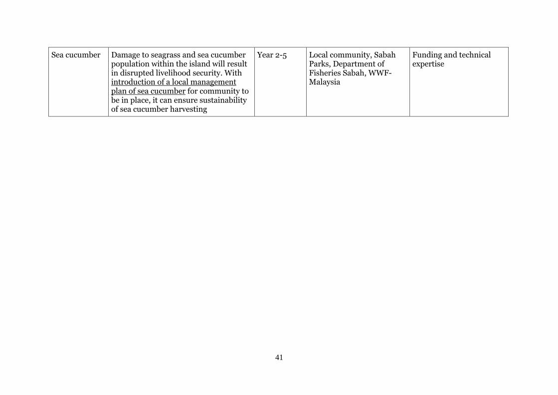
41
Sea cucumber Damage to seagrass and sea cucumber population within the island will result in disrupted livelihood security. With introduction of a local management plan of sea cucumber for community to be in place, it can ensure sustainability of sea cucumber harvesting
Year 2-5 Local community, Sabah Parks, Department of Fisheries Sabah, WWF-Malaysia
Funding and technical expertise
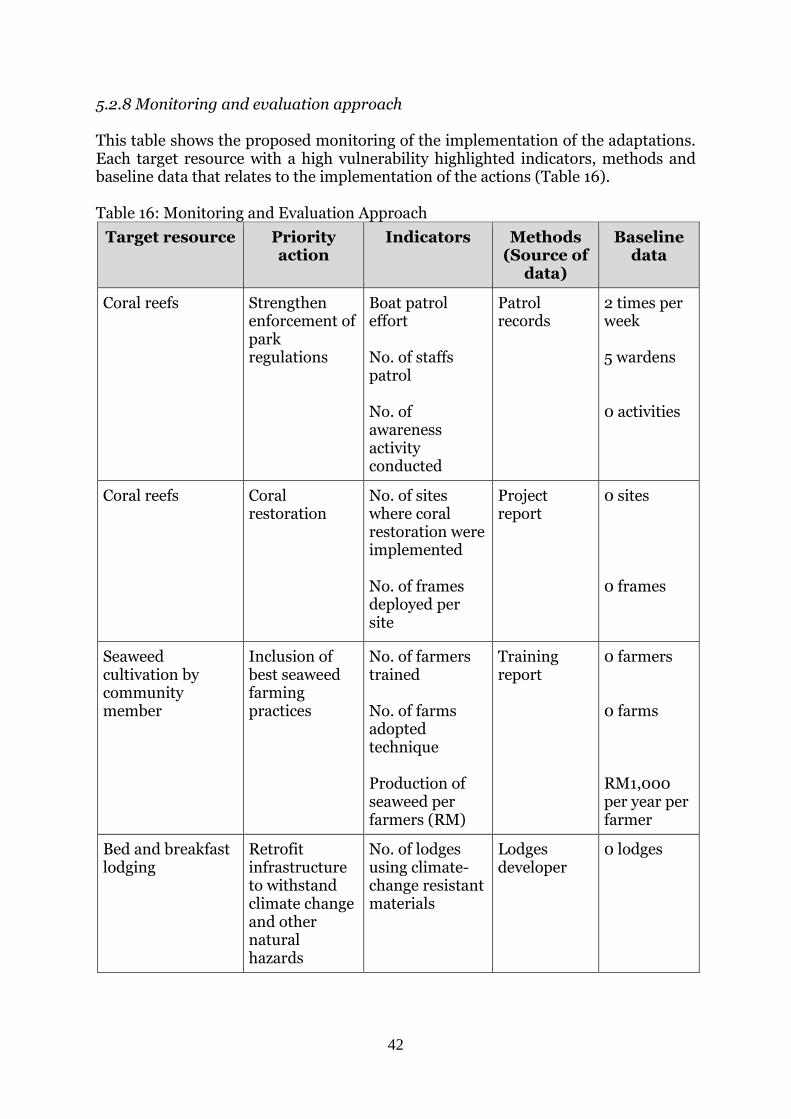
42
5.2.8 Monitoring and evaluation approach This table shows the proposed monitoring of the implementation of the adaptations. Each target resource with a high vulnerability highlighted indicators, methods and baseline data that relates to the implementation of the actions (Table 16). Table 16: Monitoring and Evaluation Approach
Target resource Priority action
Indicators Methods (Source of
data)
Baseline data
Coral reefs Strengthen enforcement of park regulations
Boat patrol effort No. of staffs patrol No. of awareness activity conducted
Patrol records
2 times per week 5 wardens 0 activities
Coral reefs Coral restoration
No. of sites where coral restoration were implemented No. of frames deployed per site
Project report
0 sites 0 frames
Seaweed cultivation by community member
Inclusion of best seaweed farming practices
No. of farmers trained No. of farms adopted technique Production of seaweed per farmers (RM)
Training report
0 farmers 0 farms RM1,000 per year per farmer
Bed and breakfast lodging
Retrofit infrastructure to withstand climate change and other natural hazards
No. of lodges using climate-change resistant materials
Lodges developer
0 lodges
43
Sea cucumber Local management plan of sea cucumbers for community in place
No. of activities supporting (awareness and educational) management of sea cucumbers conducted
Local authority, Sabah Parks
0 activities
5.3 Discussion The sea surface temperature is inter-related with the air temperature. Sea surface temperature, much like the atmosphere’s temperature, is constantly changing. Water warms up and cools down at a slower rate than air (National Oceanic and Atmospheric Administration, 2015). Warmer air temperature will lead to unpredictable seasonal monsoons which can then decrease seaweed production and disrupt mango seasonal fruiting. Seaweed cultivation is observed to be in poor condition and declining due to increased diseases. However, the decline may perhaps be largely contributed by the poor management of the farms. Increased sea surface temperature may have caused minor coral bleaching as observed by the local communities in 1980s but it may be localized bleaching as not reflected in past local media and scientific papers. In contrast, on a larger scale, there was a mass bleaching between 1997 and 1998 due to rising sea surface temperature, which affected the eastern part of Malaysia’s coral reefs (Pilcher & Cabanban, 1999). Presently, the conditions of the coral reefs are poor due to blast fishing activities (Table 14) and increased nutrient from these discharges may promote seagrass growth (Table 14). For the periodically tidal waves experienced by the island communities during king tides and storm surges, this affects the infrastructures and causes beach erosion. The good condition of fringing mangroves on certain parts of the island contributes to shoreline resilience. However, it is declining due to local usage (Table 14). Rainfall patterns contribute to low salinity and impacts farmed seaweed growth. Strong currents related to the peak of monsoon and typhoon tails leads to damage of infrastructures (fish cages, seaweed lines, break walls) and marine habitats. However, the destruction of coral reefs by typhoons was not observed in Selakan. Nonetheless, the destruction may happen in the future as it has occurred in Kota Kinabalu, Sabah (Pilcher & Cabanban, 1999). The typhoons also affect the cage culture fish with poor condition due to lack in supply of fish juveniles. Bed and breakfast infrastructures are possible damages from typhoons. The Bed and Breakfast is highly dependent on humans because of potential of the island in attracting tourists and divers. Another low in dependency is sea cucumber harvesting and goat farming for the community. Both social targets can be improved through received support by the local government which both targets provide alternative livelihoods. Vulnerability assessment for target resources shows that coral reefs, seaweed cultivation and sea cucumber harvesting are rated as high in vulnerability (Table 14). Coral reefs are high because of increased sea-surface temperature and sedimentation, and poor conditions. For seaweed cultivation, climate change indicators such as tropical cyclone, increased sea surface temperature and rainfall coupled with poor management resulting diseases led to high vulnerability. Sea cucumbers are high in vulnerability because of severe rainfall events, strong waves and currents.
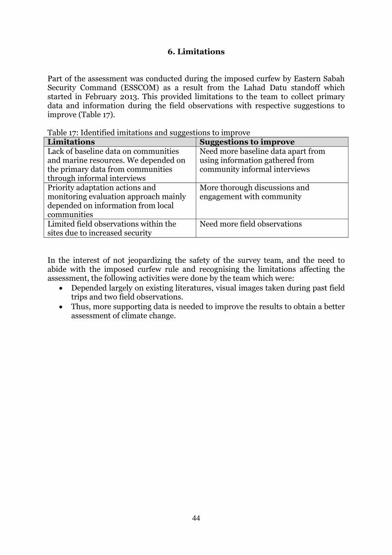
44
6. Limitations Part of the assessment was conducted during the imposed curfew by Eastern Sabah Security Command (ESSCOM) as a result from the Lahad Datu standoff which started in February 2013. This provided limitations to the team to collect primary data and information during the field observations with respective suggestions to improve (Table 17). Table 17: Identified imitations and suggestions to improve Limitations Suggestions to improve Lack of baseline data on communities and marine resources. We depended on the primary data from communities through informal interviews
Need more baseline data apart from using information gathered from community informal interviews
Priority adaptation actions and monitoring evaluation approach mainly depended on information from local communities
More thorough discussions and engagement with community
Limited field observations within the sites due to increased security
Need more field observations
In the interest of not jeopardizing the safety of the survey team, and the need to abide with the imposed curfew rule and recognising the limitations affecting the assessment, the following activities were done by the team which were:
Depended largely on existing literatures, visual images taken during past field trips and two field observations.
Thus, more supporting data is needed to improve the results to obtain a better assessment of climate change.
45
7. Conclusion The LEAP and CIVAT tools were used to assess the climate change vulnerabilities in Semporna PCA between July 2013 and June 2014. This CIVAT tool determined the vulnerability of these sites ranging from low to high. Sites C, D and E are (Denawan, Si Amil Ligitan; Mabul and Sipadan) (1.77%, 13.36km) highly vulnerable to climate change. Sites A, B, F and H (Bum-Bum, Tun Sakaran Marine Park, Northeast islands, and south Semporna mainland) (48.93%, 370.17km) are considered as medium while vulnerability of site G (north Semporna mainland) (48.93%, 370.17km) is low. The results suggest an option to determine and implement adaption measures by decision makers (government agencies, project managers, and policy makers) for the protection of island communities, private sectors (especially tourism) and the fragile marine ecosystems in the Semporna PCA. The outer islands of Semporna are highly vulnerable to climate change whereas mainland Semporna is low in vulnerability. The recommended adaptation options for the highly vulnerable sites include implementation of proper development along the sites taking into account of climate change impacts; possible relocation of highly vulnerable communities such as from Mabul Island to mainland or safer areas, and protection and restoration of key marine habitats. The Selakan Island CIVAT ranking is medium in comparison to other highly vulnerable communities. However, the adaptation measures determined by CIVAT to those identified using LEAP for Selakan are closely linked. Therefore, the LEAP was used as a complementary tool to CIVAT in determining community-based adaptation options. The LEAP tool identified three ecological and five social targets with vulnerabilities from medium to high. Coral reefs, seaweed cultivation and sea cucumber harvesting are highly vulnerable, followed by seagrass beds, fringing mangrove trees, fish cage cultures, bed and breakfast lodging and goat farming are medium in vulnerability. Priority adaptation options suggested are to strengthen the enforcement of park regulations and restoration to reduce pressure on coral reefs and increase its resilient to already occurring climate change impacts, application of best practices for seaweed farming including proper management and techniques, retrofit infrastructures to be climate-resilient for Bed and Breakfast lodging to ensure continued operations of seaweed farming and tourism, and lastly, a local management plan for sea cucumber farming for the community is in place to ensure sustainability of harvesting. The usage of the two tools provided methods for implementation by non-specialists such as coastal managers, on determining climate change vulnerability and adaptation measures. The two tools can be used on a complimentary manner - for example, CIVAT ranks vulnerability for an area or site, and LEAP enables community participation in refining the analysis and solutions identified in former tool (Table 18).
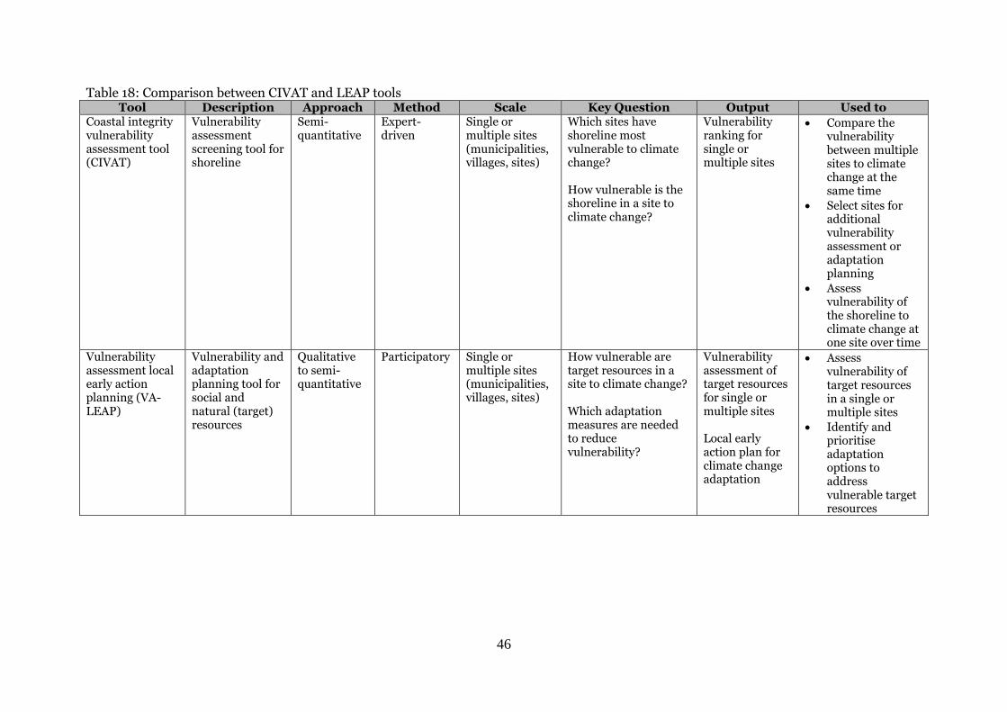
46
Table 18: Comparison between CIVAT and LEAP tools Tool Description Approach Method Scale Key Question Output Used to
Coastal integrity vulnerability assessment tool (CIVAT)
Vulnerability assessment screening tool for shoreline
Semi-quantitative
Expert-driven
Single or multiple sites (municipalities, villages, sites)
Which sites have shoreline most vulnerable to climate change? How vulnerable is the shoreline in a site to climate change?
Vulnerability ranking for single or multiple sites
Compare the vulnerability between multiple sites to climate change at the same time
Select sites for additional vulnerability assessment or adaptation planning
Assess vulnerability of the shoreline to climate change at one site over time
Vulnerability assessment local early action planning (VA-LEAP)
Vulnerability and adaptation planning tool for social and natural (target) resources
Qualitative to semi-quantitative
Participatory Single or multiple sites (municipalities, villages, sites)
How vulnerable are target resources in a site to climate change? Which adaptation measures are needed to reduce vulnerability?
Vulnerability assessment of target resources for single or multiple sites Local early action plan for climate change adaptation
Assess vulnerability of target resources in a single or multiple sites
Identify and prioritise adaptation options to address vulnerable target resources
47
8. References Aazani, M. & Mueller, M. (2015). Proceedings: Climate change seminar. Coral
Triangle Initiative. 19 March 2015. Athirah, N. C. A., Saleh, E. & Mustajap, F. (2014) Vulnerability assessment of climate
change adaptations on federal territory of Labuan, Malaysia. International Conference on Marine Science & Aquaculture 2014.
Abernethy, K., Hilly, Z., Wini Simeon, L., Posala, R., Sibiti, S., Topo, S., Apusae, T., &
Tekathoa, F. (2012). Community-based adaptation to climate change in Solomon Islands: Lessons learned from Gizo communities. Western Province. Prepared by WorldFish as part of the Coral Triangle Initiative on Coral Reefs, Fisheries and Food Security (CTI-CFF), National Program in the Solomon Islands through the Ministry of Environment, Climate Change, Disaster Management and Meteorology, and Ministry of Fisheries and Marine Resources. Funded as part of the US CTI Support Program by USAID. 44pp.
Ami Hassan, M. & Kamaludin, D. M.O. (2009). Sea level change in the Malaysian
seas from multi-satellite altimeter data. In: Postgraduate Seminar Faculty of Geoinformation Science & Engineering, 2009, Institute Ibnu Sina, UTM, Skudai.
Cazenave, A., & Nerem, R. S., (2004). Present-day sea level change. Observations
and causes. Reviews of Geophysics, 42: 1-20. Connolly, R.M. (2009). Seagrass. In: A marine climate change impacts and
adaptation report card for Australia 2009 (Eds. Poloczanska, E.S. Hobday, A.J. and Richardson, A.J.), NCCARF Publication 05/09.ISBN 978-1-921609-03-9.
Conservation International. (2013). Climate change adaptation plan for coastal
resources in Batangas Province (2014-2020). Funded as part of the US CTI Support Program by USAID.
CTI-CFF. (2009). Regional Plan of Action. Coral Triangle Initiative on Coral Reefs,
Fisheries and Food Security (CTI-CFF). Department of Survey and Mapping Malaysia. (2008). DHI Water & Environment. (2005). Sabah Shoreline Management Plan. Report
prepared by DHI Water & Environment. Edang, L. Rizally, F. A. R. Ang, N. F. A. (2008). Rumput laut perairan Sabah. Dewan
Bahasa dan Pustaka, Kuala Lumpur. Fredolin T. Tangang, Liew Juneng, Ester Salimun, Kwan Meng Sei, Loh Jui Le &
Halimatun Muhamad. (2012). Climate change and variability over Malaysia: Gaps in science and research information. Science and Research Information Sains Malaysiana 41(11): 1355–1366.
48
Gumpil, G. & de Silva, M. W. R. N. (2007). Issues and challenges of seagrass: with special reference to Sabah, Malaysia. Universiti Malaysia Sabah. Kota Kinabalu.
Hasegawa, A. & S. Emori. (2005). Tropical cyclones and associated precipitation over
the Western North Pacific: T106 atmospheric GCM simulation for present-day and doubled CO2 climates. SOLA, 1, 145-148, SOI:10.2151/sola.2005-038.
Ho, Nina, Kassem, Kenneth & Ng, Sharon. (2011). Seagrass assessment report of
Semporna Priority Conservation Area. Kota Kinabalu, Malaysia: WWF-Malaysia.
IPCC. (eds). (2007). The physical science basis. Cambridge University Press. IPCC. (2013): Climate Change 2013: The Physical Science Basis. Contribution of
Working Group I to the Fifth Assessment Report of the Intergovernmental Panel on Climate Change [Stocker, T.F., D. Qin, G.-K. Plattner, M. Tignor, S.K. Allen, J. Boschung, A. Nauels, Y. Xia, V. Bex and P.M. Midgley (eds.)]. Cambridge University Press, Cambridge, United Kingdom and New York, NY, USA, 1535 pp.
Jalil, I. (2012). Sediment grain size distribution and coastal vulnerability integrity
assessment at the coastal area of Kudat, Sabah. Undergraduate thesis. Universiti Malaysia Sabah.
Japan Meteorological Agency. (2014). Ocean acidification in the western North
Pacific. Global Environment and Marine Department. Japan Meteorological Agency.
Jolis, Gavin. (2014). An update on the marine turtle status in the northeast
Semporna Priority Conservation Area. WWF-Malaysia. Jolis, Gavin & Kassem, Kenneth. (2011). Marine turtle status in northeast Semporna
Priority Conservation Area. Kota Kinabalu, Malaysia: WWF-Malaysia. Jolis, Gavin & Jalalid, Roziah. (2014) Status penyu di Pulau Omadal, Semporna,
Malaysia. WWF-Malaysia. Kassem, K., Hoeksema, B. & Affendi, Y. A., (eds). (2012) Semporna Marine
Ecological Expedition. WWF-Malaysia, NCB Naturalis, Universiti Malaysia Sabah. Kota Kinabalu, Malaysia.
Kirk, H. J. C. (1962). The geology and mineral resources of the Semporna
Peninsula, North Borneo. Memoir 14, Geological Survey Department, British Territories in Borneo. Government Printing Office: Kuching.
Knutson, T. R. & R. E. Tuleya. (2004). Impact of CO2-Induced Warming on
Simulated Hurricane Intensity and Precipitation: Sensitivity to the Choice of Climate Model and Convective Parameterization. J. Climate, 17, 3477–3495.
Komilus, C. F., Saleh, E. & Kamu, A., (2011). Sulu-Celebes Sea Sustainable Fisheries
Management Project Interim Report. Fisheries Department Sabah.
49
Malaysian Meteorology Department (MMD). (2009). Climate change scenarios for Malaysia 2001- 2099. Malaysian Meteorological Department. Kuala Lumpur.
Ministry of Natural Resources and Environment Malaysia (2011). Malaysia second
national communication to the UNFCCC. Malaysia, ISBN 978-983- 44294-9-2.
National Hydraulic Research Institute of Malaysia & Ministry of Natural Resources
and Environment. (2010). Final report: The study of the impact of climate change on sea level rise in Malaysia. California Hydrologic Research Laboratory, USA. National Coastal Erosion Study. 1985.
National Oceanic and Atmospheric Administration. 2015. Sea surface temperature –
real time. http://sos.noaa.gov/Datasets/dataset.php?id=197. Accessed 27 July 2015.
Oouchi, K., J. Yoshimura, H. Yoshimura, R. Mizuta, S. Kusunoki & A. Noda. (2006).
Tropical cyclone climatology in a global-warming climate as simulated in a 20km-mesh global atmospheric model: frequency and wind intensity analysis. J. Meteorol. Soc. Japan, 84, 259-276.
Pilcher, N. & Cabanban, A. (1999). The status of coral reefs in eastern Malaysia.
Australian Institute of Marine Science. Piper, M. (1981). Report on human settlements. WWF Survey Expedition to
Semporna 1980. Sabah Museum. In: Semporna Islands Park Management Plan. Proposed through the Semporna Islands Project. January 2001.
Razak, F. R. (2013). Personal communication. Sabah Parks. Rhein, M., S. R. Rintoul, S. Aoki, E. Campos, D. Chambers, R.A. Feely, S. Gulev, G.C.
Johnson, S.A. Josey, A. Kostianoy, C. Mauritzen, D. Roemmich, L.D. Talley and F. Wang. (2013). Observations: Ocean. In: Climate Change 2013: The Physical Science Basis. Contribution of Working Group I to the Fifth Assessment Report of the Intergovernmental Panel on Climate Change [Stocker, T.F., D. Qin, G.-K. Plattner, M. Tignor, S.K. Allen, J. Boschung, A. Nauels, Y. Xia, V. Bex and P.M. Midgley (eds.)]. Cambridge University Press, Cambridge, United Kingdom and New York, NY, USA.
Royal Malaysian Navy. (1998a). Sipadan – Ligitan. MAL 8421. Royal Malaysian Navy. (1998b). Telukan Lahad Datu. MAL 8503. Royal Malaysian Navy (1998c). Teluk Sibuko Utara. MAL 8434. Royal Malaysian Navy. (1998d). Terusan Tando Bulong. MAL 8433. Sabah Forestry Department. (2007). Sabah’s mangrove forests: Towards
conservation & sustainable use. Sabah Forestry Department, Sabah.
50
Saleh, E., Matsumoto, M. M. B. & Mojiol, A. R. (2011). Mangrove ecosystem in Semporna Priority Conservation Area. WWF- Malaysia.
Saleh, E., Aung, T., Muslim, M. A., Bagul, A.H.B. & Abdul Razak, F. R. (2012).
Shoreline Dynamics of Turtle Islands Park in Sandakan, Sabah, Malaysia in BEC2012 conference proceedings: Enhancing Sustainability, Competitiveness and Innovation in the BIMP-EAGA- ISBN: 983-2641-88-9.
Siringan, F. P., Sta Maria, M. Y.Y., Samson, M. I., Licanan, W. R. Y., & Rollon, R.
(2013). Chapter 5. Coastal Integrity Vulnerability Assessment Tool. In: MERF. 2013. Vulnerability Assessment Tools for Coastal ecosystems: A Guidebook. Marine Environment and Resources Foundation. Inc.: Quezon City, Philippines.
United Nations University. (2013). World Risk Report. Alliance Development
Works/Bündnis Entwicklung Hilft (BEH). U.S. Coral Triangle Initiative Support Program. (2013). Climate Change Adaptation
for Coral Triangle Communities: Guide for Vulnerability Assessment and Local Early Action Planning (LEAP Guide). Prepared with support from the United States Agency for International Development.
Walsh, K. J. E., K.-C. Nguyen & J. L. McGregor. (2004). Fine-resolution regional
climate model simulations of the impact of climate change on tropical cyclones near Australia. Clim. Dyn., 22, 47-56, DOI: 10.1007/s00382-003-0362-0
Wilkinson, C. (2008). Status of Coral Reefs of the World: 2008. Global Coral Reef
Monitoring Network & Reef and Rainforest Research Centre, Townsville. Willis, J. K., Chambers, D. P., Chung-Yen Kuo & Shum,C. K. (2010). Global sea level
rise. Recent progress and challenges for the decade to come. Oceanography Vo. 23, No. 4.
Wood, C. R. (1987). Physical features of the islands and coral reefs. In: The corals
reefs of the Bodgaya Islands (Sabah: Malaysia) and Pulau Sipadan. Malay Nat J 40: 169-188.
Wood, C. R. (1994). Physical features of the Sipadan reef. In: Pulau Sipadan: Reef
life and ecology. Technical report, WWF Project Number MYS 233/92, Petaling Jaya, Malaysia, 11-22pp.
Wood, E. (2001). Semporna Islands Park Management Plan. Proposed through the
Semporna Islands Project, 167pp.
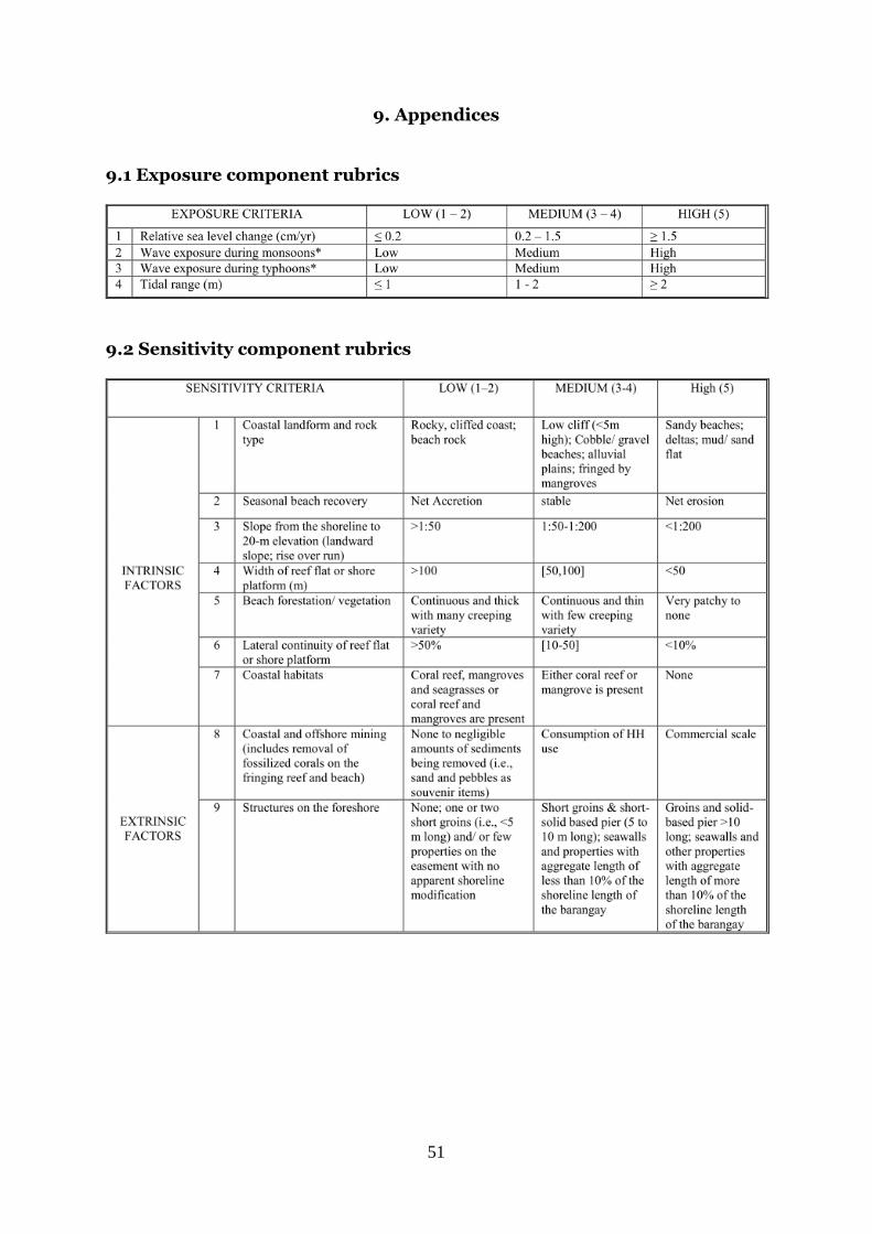
51
9. Appendices 9.1 Exposure component rubrics
9.2 Sensitivity component rubrics
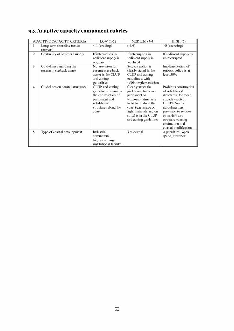
52
9.3 Adaptive capacity component rubrics
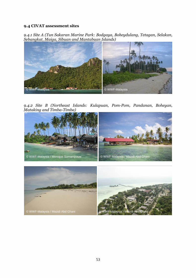
53
9.4 CIVAT assessment sites 9.4.1 Site A (Tun Sakaran Marine Park: Bodgaya, Boheydulang, Tetagan, Selakan, Sebangkat, Maiga, Sibuan and Mantabuan Islands)
9.4.2 Site B (Northeast Islands: Kulapuan, Pom-Pom, Pandanan, Boheyan, Mataking and Timba-Timba)
© WWF-Malaysia / Monique Sumampouw
© WWF-Malaysia © WWF-Malaysia
© WWF-Malaysia / Mazidi Abd Ghani
© WWF-Malaysia / Mazidi Abd Ghani © WWF-Malaysia / Mazidi Abd Ghani
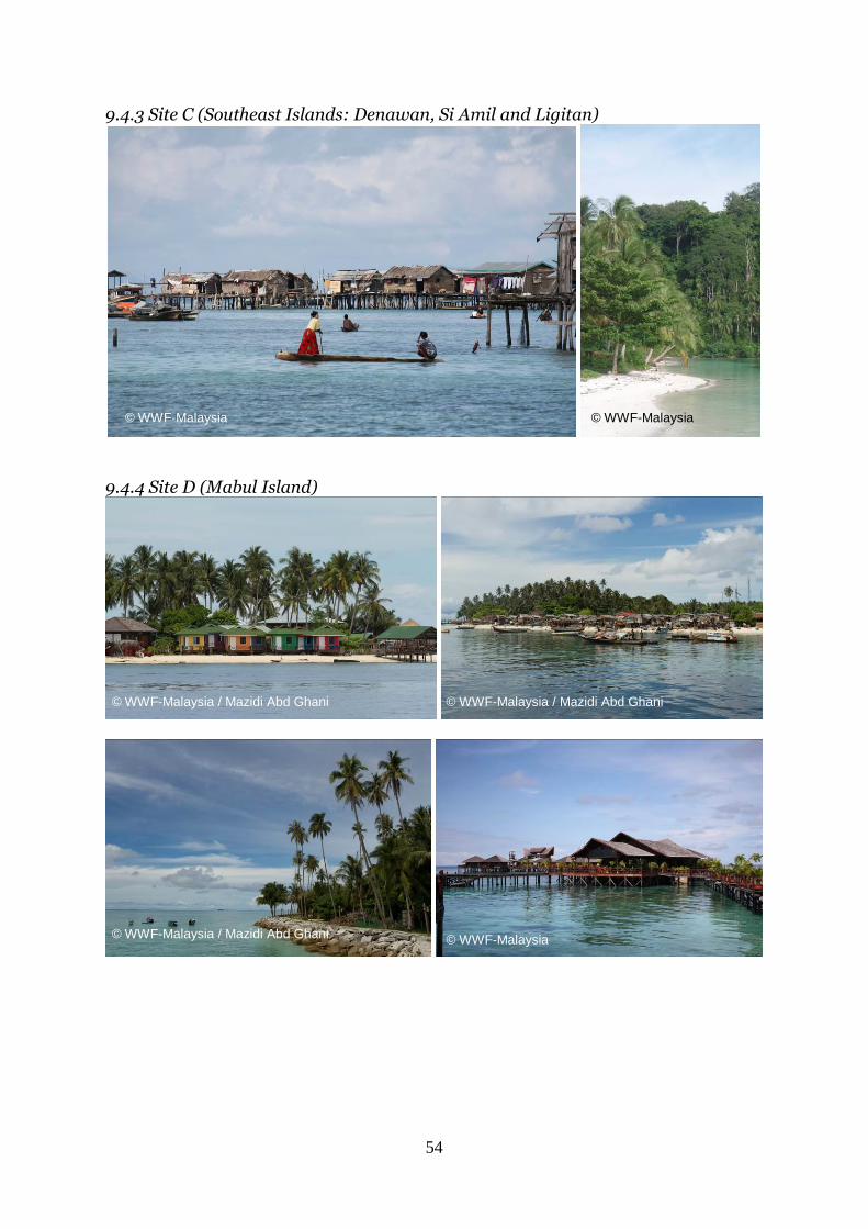
54
9.4.3 Site C (Southeast Islands: Denawan, Si Amil and Ligitan)
9.4.4 Site D (Mabul Island)
© WWF-Malaysia © WWF-Malaysia
© WWF-Malaysia / Mazidi Abd Ghani © WWF-Malaysia / Mazidi Abd Ghani
© WWF-Malaysia / Mazidi Abd Ghani © WWF-Malaysia
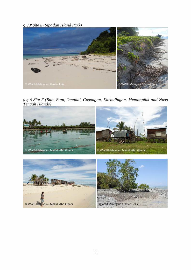
55
9.4.5 Site E (Sipadan Island Park)
9.4.6 Site F (Bum-Bum, Omadal, Gusungan, Karindingan, Menampilik and Nusa Tengah Islands)
© WWF-Malaysia / Gavin Jolis © WWF-Malaysia / Gavin Jolis
© WWF-Malaysia / Mazidi Abd Ghani © WWF-Malaysia / Mazidi Abd Ghani
© WWF-Malaysia / Gavin Jolis © WWF-Malaysia / Mazidi Abd Ghani
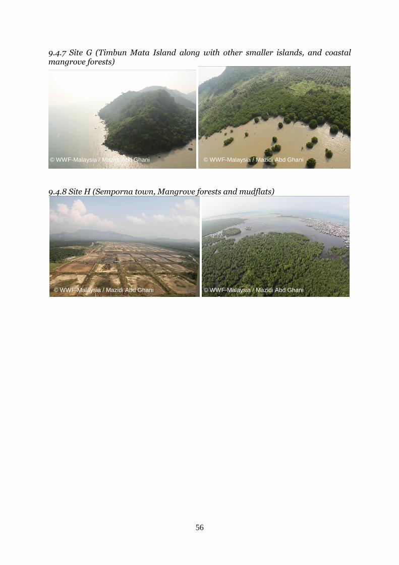
56
9.4.7 Site G (Timbun Mata Island along with other smaller islands, and coastal mangrove forests)
9.4.8 Site H (Semporna town, Mangrove forests and mudflats)
© WWF-Malaysia / Mazidi Abd Ghani © WWF-Malaysia / Mazidi Abd Ghani
© WWF-Malaysia / Mazidi Abd Ghani © WWF-Malaysia / Mazidi Abd Ghani
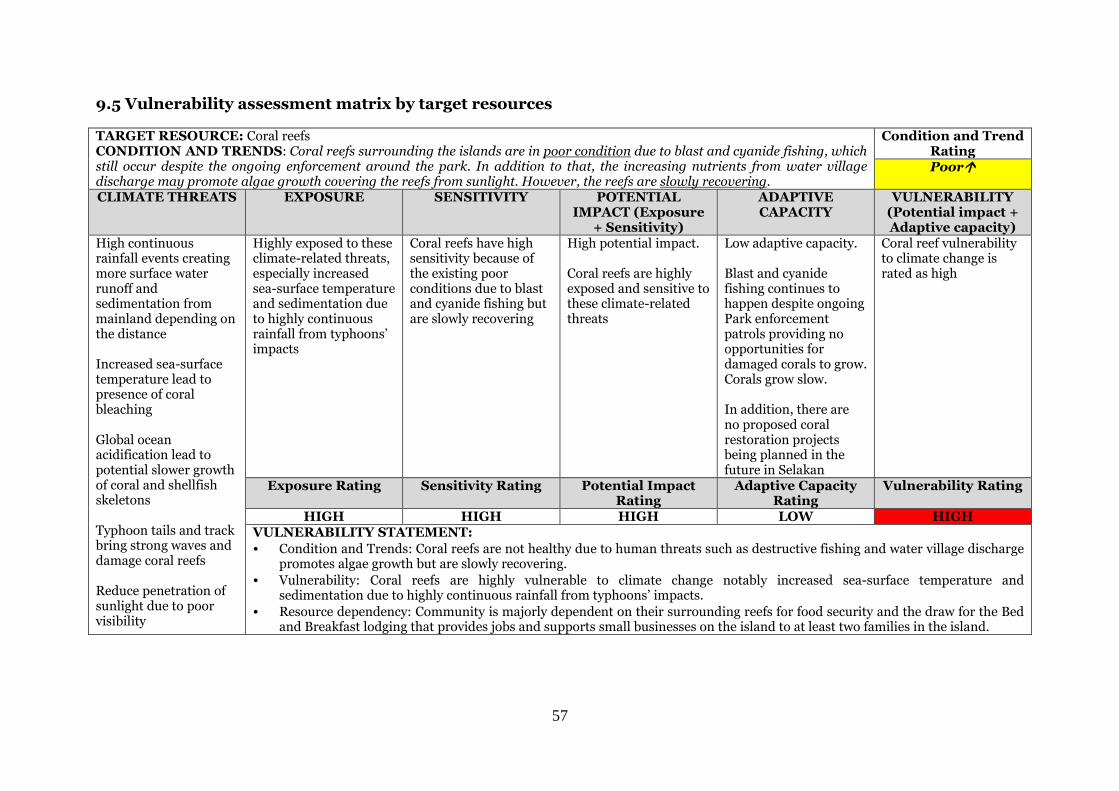
57
9.5 Vulnerability assessment matrix by target resources TARGET RESOURCE: Coral reefs CONDITION AND TRENDS: Coral reefs surrounding the islands are in poor condition due to blast and cyanide fishing, which still occur despite the ongoing enforcement around the park. In addition to that, the increasing nutrients from water village discharge may promote algae growth covering the reefs from sunlight. However, the reefs are slowly recovering.
Condition and Trend Rating Poor
CLIMATE THREATS EXPOSURE SENSITIVITY POTENTIAL IMPACT (Exposure
+ Sensitivity)
ADAPTIVE CAPACITY
VULNERABILITY (Potential impact + Adaptive capacity)
High continuous rainfall events creating more surface water runoff and sedimentation from mainland depending on the distance Increased sea-surface temperature lead to presence of coral bleaching Global ocean acidification lead to potential slower growth of coral and shellfish skeletons Typhoon tails and track bring strong waves and damage coral reefs Reduce penetration of sunlight due to poor visibility
Highly exposed to these climate-related threats, especially increased sea-surface temperature and sedimentation due to highly continuous rainfall from typhoons’ impacts
Coral reefs have high sensitivity because of the existing poor conditions due to blast and cyanide fishing but are slowly recovering
High potential impact. Coral reefs are highly exposed and sensitive to these climate-related threats
Low adaptive capacity. Blast and cyanide fishing continues to happen despite ongoing Park enforcement patrols providing no opportunities for damaged corals to grow. Corals grow slow. In addition, there are no proposed coral restoration projects being planned in the future in Selakan
Coral reef vulnerability to climate change is rated as high
Exposure Rating Sensitivity Rating Potential Impact Rating
Adaptive Capacity Rating
Vulnerability Rating
HIGH HIGH HIGH LOW HIGH VULNERABILITY STATEMENT:
• Condition and Trends: Coral reefs are not healthy due to human threats such as destructive fishing and water village discharge promotes algae growth but are slowly recovering.
• Vulnerability: Coral reefs are highly vulnerable to climate change notably increased sea-surface temperature and sedimentation due to highly continuous rainfall from typhoons’ impacts.
• Resource dependency: Community is majorly dependent on their surrounding reefs for food security and the draw for the Bed and Breakfast lodging that provides jobs and supports small businesses on the island to at least two families in the island.
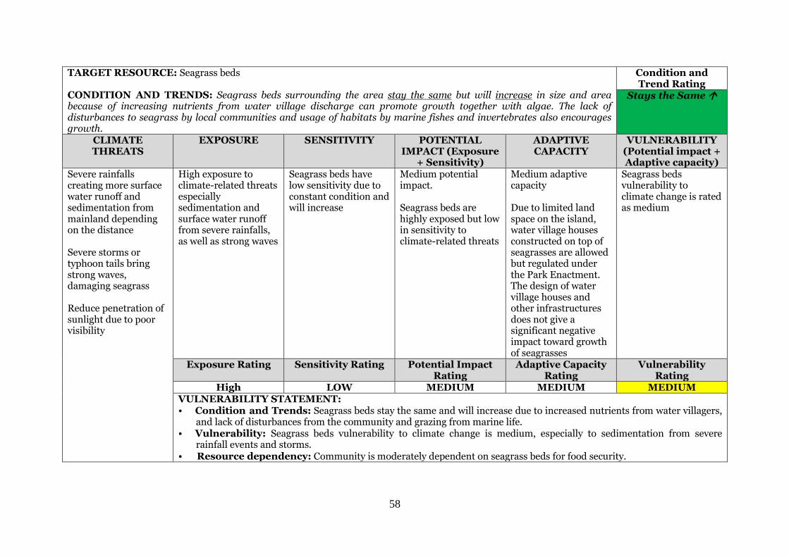
58
TARGET RESOURCE: Seagrass beds
CONDITION AND TRENDS: Seagrass beds surrounding the area stay the same but will increase in size and area because of increasing nutrients from water village discharge can promote growth together with algae. The lack of disturbances to seagrass by local communities and usage of habitats by marine fishes and invertebrates also encourages growth.
Condition and Trend Rating
Stays the Same
CLIMATE THREATS
EXPOSURE SENSITIVITY POTENTIAL IMPACT (Exposure
+ Sensitivity)
ADAPTIVE CAPACITY
VULNERABILITY (Potential impact + Adaptive capacity)
Severe rainfalls creating more surface water runoff and sedimentation from mainland depending on the distance Severe storms or typhoon tails bring strong waves, damaging seagrass Reduce penetration of sunlight due to poor visibility
High exposure to climate-related threats especially sedimentation and surface water runoff from severe rainfalls, as well as strong waves
Seagrass beds have low sensitivity due to constant condition and will increase
Medium potential impact. Seagrass beds are highly exposed but low in sensitivity to climate-related threats
Medium adaptive capacity Due to limited land space on the island, water village houses constructed on top of seagrasses are allowed but regulated under the Park Enactment. The design of water village houses and other infrastructures does not give a significant negative impact toward growth of seagrasses
Seagrass beds vulnerability to climate change is rated as medium
Exposure Rating Sensitivity Rating Potential Impact Rating
Adaptive Capacity Rating
Vulnerability Rating
High LOW MEDIUM MEDIUM MEDIUM VULNERABILITY STATEMENT: • Condition and Trends: Seagrass beds stay the same and will increase due to increased nutrients from water villagers,
and lack of disturbances from the community and grazing from marine life. • Vulnerability: Seagrass beds vulnerability to climate change is medium, especially to sedimentation from severe
rainfall events and storms. • Resource dependency: Community is moderately dependent on seagrass beds for food security.
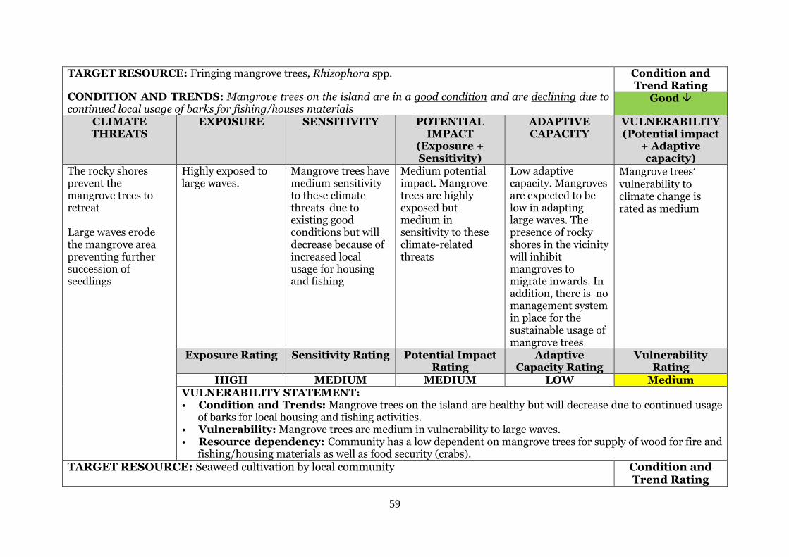
59
TARGET RESOURCE: Fringing mangrove trees, Rhizophora spp.
CONDITION AND TRENDS: Mangrove trees on the island are in a good condition and are declining due to continued local usage of barks for fishing/houses materials
Condition and Trend Rating
Good
CLIMATE THREATS
EXPOSURE SENSITIVITY POTENTIAL IMPACT
(Exposure + Sensitivity)
ADAPTIVE CAPACITY
VULNERABILITY (Potential impact
+ Adaptive capacity)
The rocky shores prevent the mangrove trees to retreat Large waves erode the mangrove area preventing further succession of seedlings
Highly exposed to large waves.
Mangrove trees have medium sensitivity to these climate threats due to existing good conditions but will decrease because of increased local usage for housing and fishing
Medium potential impact. Mangrove trees are highly exposed but medium in sensitivity to these climate-related threats
Low adaptive capacity. Mangroves are expected to be low in adapting large waves. The presence of rocky shores in the vicinity will inhibit mangroves to migrate inwards. In addition, there is no management system in place for the sustainable usage of mangrove trees
Mangrove trees’ vulnerability to climate change is rated as medium
Exposure Rating Sensitivity Rating Potential Impact Rating
Adaptive Capacity Rating
Vulnerability Rating
HIGH MEDIUM MEDIUM LOW Medium
VULNERABILITY STATEMENT: • Condition and Trends: Mangrove trees on the island are healthy but will decrease due to continued usage
of barks for local housing and fishing activities. • Vulnerability: Mangrove trees are medium in vulnerability to large waves. • Resource dependency: Community has a low dependent on mangrove trees for supply of wood for fire and
fishing/housing materials as well as food security (crabs).
TARGET RESOURCE: Seaweed cultivation by local community Condition and Trend Rating
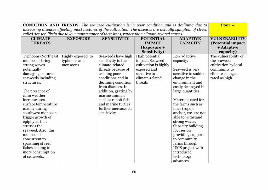
60
CONDITION AND TRENDS: The seaweed cultivation is in poor condition and is declining due to increasing diseases affecting most hectares of the cultivation. The diseases are actually symptom of stress called ‘ice-ice’ likely due to low maintenance of their lines, rather than climate-related causes.
Poor
CLIMATE THREATS
EXPOSURE SENSITIVITY POTENTIAL IMPACT
(Exposure + Sensitivity)
ADAPTIVE CAPACITY
VULNERABILITY (Potential impact
+ Adaptive capacity)
Typhoons/Northeast monsoons bring strong waves potentially damaging cultured seaweeds including structures. The presence of calm weather increases sea-surface temperature mainly during southwest monsoon trigger growth of epiphytes that stresses the seaweed. Also, this monsoon is concurrent to spawning of reef fishes leading to more consumption of seaweeds.
Highly exposed to typhoons and monsoons
Seaweeds have high sensitivity to the climate-related threats because of existing poor conditions and in declining condition from diseases. In addition, grazing by marine animals such as rabbit fish and marine turtles further increases its sensitivity
High potential impact. Seaweed cultivation is highly exposed and sensitive to climate-related threats
Low adaptive capacity. Seaweed is very sensitive to sudden change in the environment and easily destroyed in large quantities. Materials used for the farms such as lines (rope), anchor, etc. are not able to withstand strong waves. Capacity building focuses on providing support to community farms through UMS project with introduced technology advances
The vulnerability of the seaweed cultivation by local community to climate change is rated as high
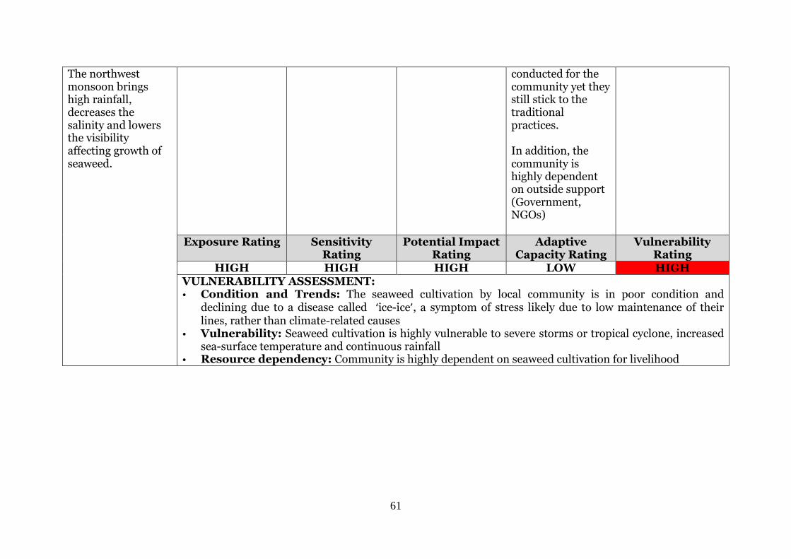
61
The northwest monsoon brings high rainfall, decreases the salinity and lowers the visibility affecting growth of seaweed.
conducted for the community yet they still stick to the traditional practices. In addition, the community is highly dependent on outside support (Government, NGOs)
Exposure Rating Sensitivity Rating
Potential Impact Rating
Adaptive Capacity Rating
Vulnerability Rating
HIGH HIGH HIGH LOW HIGH VULNERABILITY ASSESSMENT: • Condition and Trends: The seaweed cultivation by local community is in poor condition and
declining due to a disease called ‘ice-ice’, a symptom of stress likely due to low maintenance of their lines, rather than climate-related causes
• Vulnerability: Seaweed cultivation is highly vulnerable to severe storms or tropical cyclone, increased sea-surface temperature and continuous rainfall
• Resource dependency: Community is highly dependent on seaweed cultivation for livelihood
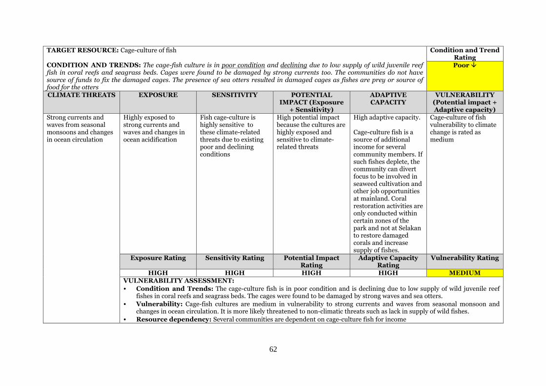
62
TARGET RESOURCE: Cage-culture of fish
CONDITION AND TRENDS: The cage-fish culture is in poor condition and declining due to low supply of wild juvenile reef fish in coral reefs and seagrass beds. Cages were found to be damaged by strong currents too. The communities do not have source of funds to fix the damaged cages. The presence of sea otters resulted in damaged cages as fishes are prey or source of food for the otters
Condition and Trend Rating Poor
CLIMATE THREATS EXPOSURE SENSITIVITY POTENTIAL IMPACT (Exposure
+ Sensitivity)
ADAPTIVE CAPACITY
VULNERABILITY (Potential impact + Adaptive capacity)
Strong currents and waves from seasonal monsoons and changes in ocean circulation
Highly exposed to strong currents and waves and changes in ocean acidification
Fish cage-culture is highly sensitive to these climate-related threats due to existing poor and declining conditions
High potential impact because the cultures are highly exposed and sensitive to climate-related threats
High adaptive capacity. Cage-culture fish is a source of additional income for several community members. If such fishes deplete, the community can divert focus to be involved in seaweed cultivation and other job opportunities at mainland. Coral restoration activities are only conducted within certain zones of the park and not at Selakan to restore damaged corals and increase supply of fishes.
Cage-culture of fish vulnerability to climate change is rated as medium
Exposure Rating Sensitivity Rating Potential Impact Rating
Adaptive Capacity Rating
Vulnerability Rating
HIGH HIGH HIGH HIGH MEDIUM VULNERABILITY ASSESSMENT:
• Condition and Trends: The cage-culture fish is in poor condition and is declining due to low supply of wild juvenile reef fishes in coral reefs and seagrass beds. The cages were found to be damaged by strong waves and sea otters.
• Vulnerability: Cage-fish cultures are medium in vulnerability to strong currents and waves from seasonal monsoon and changes in ocean circulation. It is more likely threatened to non-climatic threats such as lack in supply of wild fishes.
• Resource dependency: Several communities are dependent on cage-culture fish for income
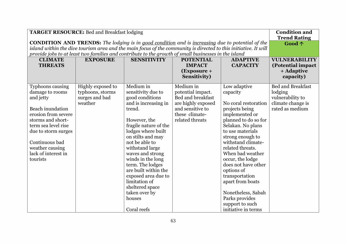
63
TARGET RESOURCE: Bed and Breakfast lodging
CONDITION AND TRENDS: The lodging is in good condition and is increasing due to potential of the island within the dive tourism area and the main focus of the community is directed to this initiative. It will provide jobs to at least two families and contribute to the growth of small businesses in the island
Condition and Trend Rating
Good
CLIMATE THREATS
EXPOSURE SENSITIVITY POTENTIAL IMPACT
(Exposure + Sensitivity)
ADAPTIVE CAPACITY
VULNERABILITY (Potential impact
+ Adaptive capacity)
Typhoons causing damage to rooms and jetty Beach inundation erosion from severe storms and short-term sea level rise due to storm surges Continuous bad weather causing lack of interest in tourists
Highly exposed to typhoons, storms surges and bad weather
Medium in sensitivity due to good conditions and is increasing in trend. However, the fragile nature of the lodges where built on stilts and may not be able to withstand large waves and strong winds in the long term. The lodges are built within the exposed area due to limitation of sheltered space taken over by houses Coral reefs
Medium in potential impact. Bed and breakfast are highly exposed and sensitive to these climate-related threats
Low adaptive capacity No coral restoration projects being implemented or planned to do so for Selakan. No plans to use materials strong enough to withstand climate-related threats. When bad weather occur, the lodge does not have other options of transportation apart from boats Nonetheless, Sabah Parks provides support to such initiative in terms
Bed and Breakfast lodging vulnerability to climate change is rated as medium
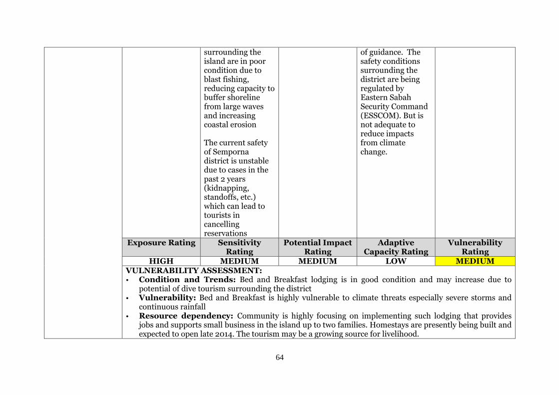
64
surrounding the island are in poor condition due to blast fishing, reducing capacity to buffer shoreline from large waves and increasing coastal erosion The current safety of Semporna district is unstable due to cases in the past 2 years (kidnapping, standoffs, etc.) which can lead to tourists in cancelling reservations
of guidance. The safety conditions surrounding the district are being regulated by Eastern Sabah Security Command (ESSCOM). But is not adequate to reduce impacts from climate change.
Exposure Rating Sensitivity Rating
Potential Impact Rating
Adaptive Capacity Rating
Vulnerability Rating
HIGH MEDIUM MEDIUM LOW MEDIUM VULNERABILITY ASSESSMENT: • Condition and Trends: Bed and Breakfast lodging is in good condition and may increase due to
potential of dive tourism surrounding the district • Vulnerability: Bed and Breakfast is highly vulnerable to climate threats especially severe storms and
continuous rainfall • Resource dependency: Community is highly focusing on implementing such lodging that provides
jobs and supports small business in the island up to two families. Homestays are presently being built and expected to open late 2014. The tourism may be a growing source for livelihood.
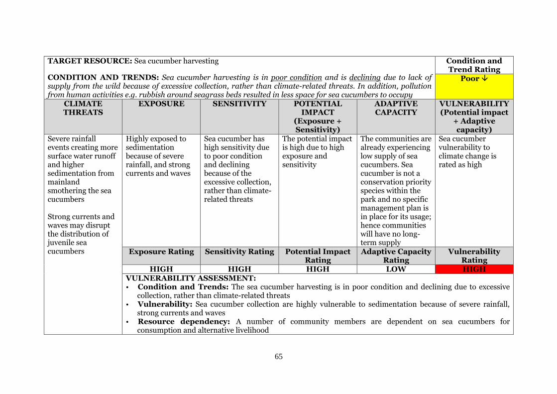
65
TARGET RESOURCE: Sea cucumber harvesting
CONDITION AND TRENDS: Sea cucumber harvesting is in poor condition and is declining due to lack of supply from the wild because of excessive collection, rather than climate-related threats. In addition, pollution from human activities e.g. rubbish around seagrass beds resulted in less space for sea cucumbers to occupy
Condition and Trend Rating
Poor
CLIMATE THREATS
EXPOSURE SENSITIVITY POTENTIAL IMPACT
(Exposure + Sensitivity)
ADAPTIVE CAPACITY
VULNERABILITY (Potential impact
+ Adaptive capacity)
Severe rainfall events creating more surface water runoff and higher sedimentation from mainland smothering the sea cucumbers Strong currents and waves may disrupt the distribution of juvenile sea cucumbers
Highly exposed to sedimentation because of severe rainfall, and strong currents and waves
Sea cucumber has high sensitivity due to poor condition and declining because of the excessive collection, rather than climate-related threats
The potential impact is high due to high exposure and sensitivity
The communities are already experiencing low supply of sea cucumbers. Sea cucumber is not a conservation priority species within the park and no specific management plan is in place for its usage; hence communities will have no long-term supply
Sea cucumber vulnerability to climate change is rated as high
Exposure Rating Sensitivity Rating Potential Impact Rating
Adaptive Capacity Rating
Vulnerability Rating
HIGH HIGH HIGH LOW HIGH VULNERABILITY ASSESSMENT: • Condition and Trends: The sea cucumber harvesting is in poor condition and declining due to excessive
collection, rather than climate-related threats • Vulnerability: Sea cucumber collection are highly vulnerable to sedimentation because of severe rainfall,
strong currents and waves • Resource dependency: A number of community members are dependent on sea cucumbers for
consumption and alternative livelihood

66
TARGET RESOURCE: Goat farming
CONDITION AND TRENDS: Goat farming is in good condition and is increasing due to existing support from the local government. Nonetheless, there is a lack of awareness among communities on such opportunities and lack of space to farm on the island
Condition and Trend Rating Good
CLIMATE THREATS EXPOSURE SENSITIVITY POTENTIAL IMPACT (Exposure + Sensitivity)
ADAPTIVE CAPACITY
VULNERABILITY (Potential impact + Adaptive capacity)
Prolonged bad weather results in government support such as fertiliser, vitamins to be intermittent Droughts will decrease the grass cover around the island reducing food sources for goats
Highly exposed to bad weather and droughts
Goat farming has low sensitivity due to its good condition and is increasing because of the existing support from local governments
The potential impact towards goat farming is medium due to high exposure and low sensitivity from the climate-related threats
Adaptive capacity is medium. The potential to grow the existing local farming to a small-scale and organised farming is promising since local government support is available despite the lack of space to farm. If such grass supply for food is low, other options for feeding supply are available When such bad weathers occurs, there will be lack of transportation options to bring food, fertilisers, vitamins, etc.
Goat farming vulnerability to climate change is rated as medium
Exposure Rating Sensitivity Rating Potential Impact Rating
Adaptive Capacity Rating
Vulnerability Rating
HIGH LOW MEDIUM MEDIUM MEDIUM VULNERABILITY ASSESSMENT:
• Condition and Trends: The goat farming around Selakan Island are in good condition and increasing due to support from local government
• Vulnerability: Goat farming is medium in vulnerability due to bad weather and droughts
• Resource dependency: A few community members are dependent on goat farming in limited grass space around the island for alternative livelihood
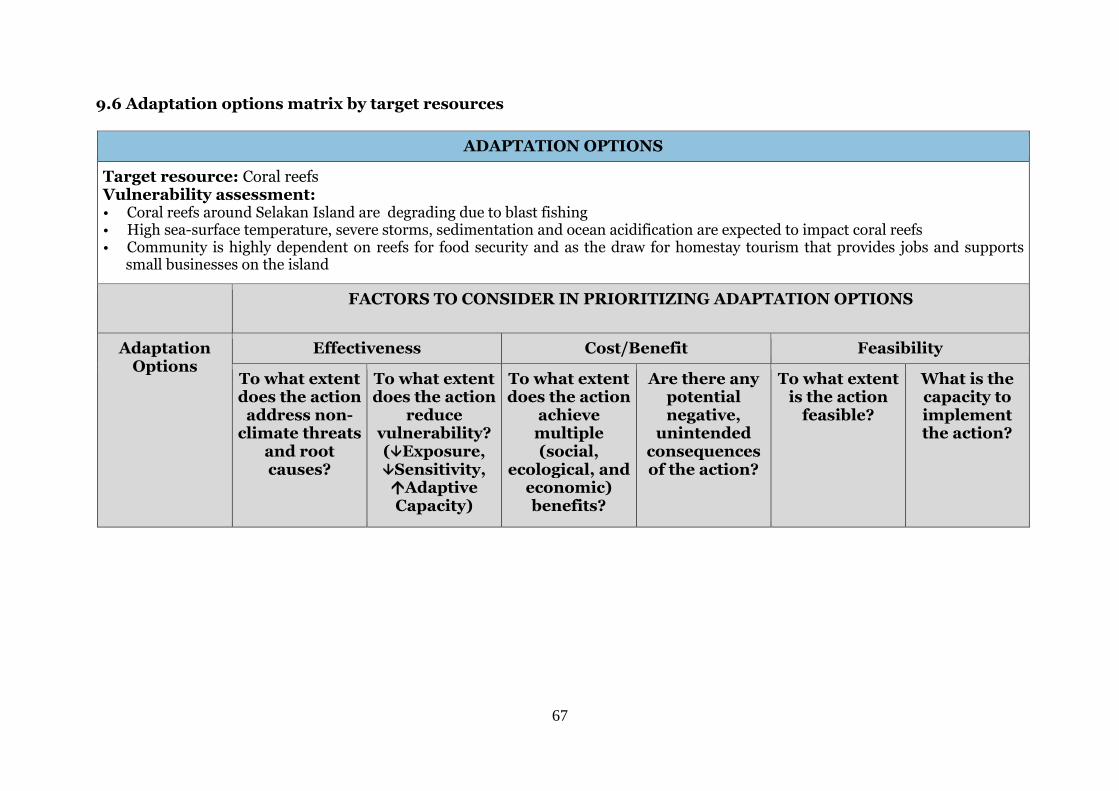
67
9.6 Adaptation options matrix by target resources
ADAPTATION OPTIONS
Target resource: Coral reefs Vulnerability assessment: • Coral reefs around Selakan Island are degrading due to blast fishing • High sea-surface temperature, severe storms, sedimentation and ocean acidification are expected to impact coral reefs • Community is highly dependent on reefs for food security and as the draw for homestay tourism that provides jobs and supports
small businesses on the island
FACTORS TO CONSIDER IN PRIORITIZING ADAPTATION OPTIONS
Adaptation Options
Effectiveness Cost/Benefit Feasibility
To what extent does the action
address non-climate threats
and root causes?
To what extent does the action
reduce vulnerability? (Exposure, Sensitivity, Adaptive Capacity)
To what extent does the action
achieve multiple (social,
ecological, and economic) benefits?
Are there any potential negative,
unintended consequences of the action?
To what extent is the action
feasible?
What is the capacity to implement the action?
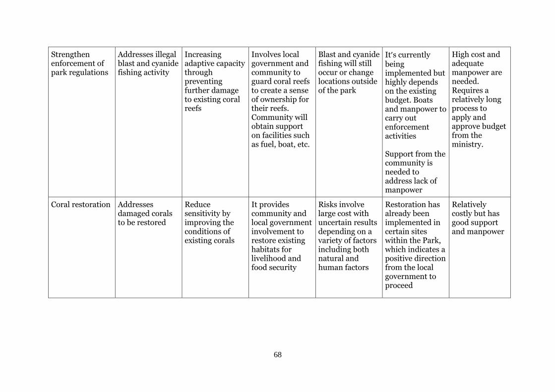
68
Strengthen enforcement of park regulations
Addresses illegal blast and cyanide fishing activity
Increasing adaptive capacity through preventing further damage to existing coral reefs
Involves local government and community to guard coral reefs to create a sense of ownership for their reefs. Community will obtain support on facilities such as fuel, boat, etc.
Blast and cyanide fishing will still occur or change locations outside of the park
It’s currently being implemented but highly depends on the existing budget. Boats and manpower to carry out enforcement activities Support from the community is needed to address lack of manpower
High cost and adequate manpower are needed. Requires a relatively long process to apply and approve budget from the ministry.
Coral restoration Addresses damaged corals to be restored
Reduce sensitivity by improving the conditions of existing corals
It provides community and local government involvement to restore existing habitats for livelihood and food security
Risks involve large cost with uncertain results depending on a variety of factors including both natural and human factors
Restoration has already been implemented in certain sites within the Park, which indicates a positive direction from the local government to proceed
Relatively costly but has good support and manpower
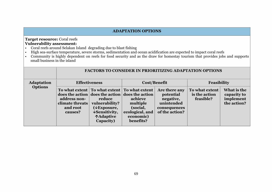
69
ADAPTATION OPTIONS
Target resource: Coral reefs Vulnerability assessment: • Coral reefs around Selakan Island degrading due to blast fishing • High sea-surface temperature, severe storms, sedimentation and ocean acidification are expected to impact coral reefs • Community is highly dependent on reefs for food security and as the draw for homestay tourism that provides jobs and supports
small business in the island
FACTORS TO CONSIDER IN PRIORITIZING ADAPTATION OPTIONS
Adaptation Options
Effectiveness Cost/Benefit Feasibility
To what extent does the action
address non-climate threats
and root causes?
To what extent does the action
reduce vulnerability? (Exposure, Sensitivity, Adaptive Capacity)
To what extent does the action
achieve multiple (social,
ecological, and economic) benefits?
Are there any potential negative,
unintended consequences of the action?
To what extent is the action
feasible?
What is the capacity to implement the action?
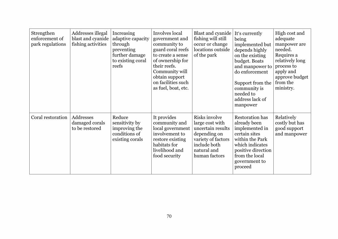
70
Strengthen enforcement of park regulations
Addresses illegal blast and cyanide fishing activities
Increasing adaptive capacity through preventing further damage to existing coral reefs
Involves local government and community to guard coral reefs to create a sense of ownership for their reefs. Community will obtain support on facilities such as fuel, boat, etc.
Blast and cyanide fishing will still occur or change locations outside of the park
It’s currently being implemented but depends highly on the existing budget. Boats and manpower to do enforcement Support from the community is needed to address lack of manpower
High cost and adequate manpower are needed. Requires a relatively long process to apply and approve budget from the ministry.
Coral restoration Addresses damaged corals to be restored
Reduce sensitivity by improving the conditions of existing corals
It provides community and local government involvement to restore existing habitats for livelihood and food security
Risks involve large cost with uncertain results depending on variety of factors include both natural and human factors
Restoration has already been implemented in certain sites within the Park which indicates positive direction from the local government to proceed
Relatively costly but has good support and manpower
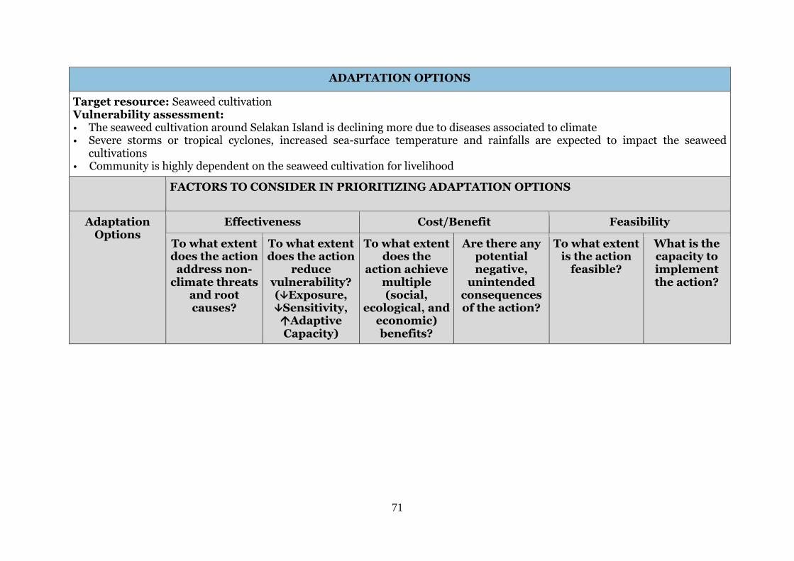
71
ADAPTATION OPTIONS
Target resource: Seaweed cultivation Vulnerability assessment: • The seaweed cultivation around Selakan Island is declining more due to diseases associated to climate
• Severe storms or tropical cyclones, increased sea-surface temperature and rainfalls are expected to impact the seaweed cultivations
• Community is highly dependent on the seaweed cultivation for livelihood
FACTORS TO CONSIDER IN PRIORITIZING ADAPTATION OPTIONS
Adaptation Options
Effectiveness Cost/Benefit Feasibility
To what extent does the action
address non-climate threats
and root causes?
To what extent does the action
reduce vulnerability? (Exposure, Sensitivity, Adaptive Capacity)
To what extent does the
action achieve multiple (social,
ecological, and economic) benefits?
Are there any potential negative,
unintended consequences of the action?
To what extent is the action
feasible?
What is the capacity to implement the action?
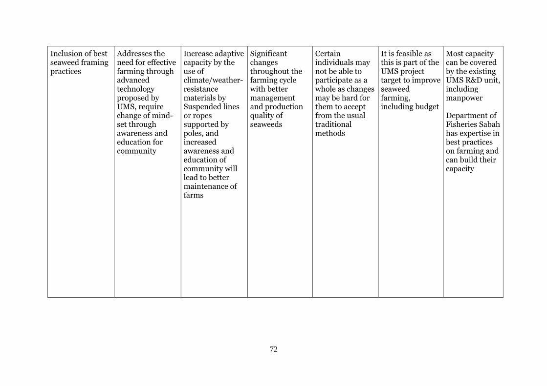
72
Inclusion of best seaweed framing practices
Addresses the need for effective farming through advanced technology proposed by UMS, require change of mind-set through awareness and education for community
Increase adaptive capacity by the use of climate/weather- resistance materials by Suspended lines or ropes supported by poles, and increased awareness and education of community will lead to better maintenance of farms
Significant changes throughout the farming cycle with better management and production quality of seaweeds
Certain individuals may not be able to participate as a whole as changes may be hard for them to accept from the usual traditional methods
It is feasible as this is part of the UMS project target to improve seaweed farming, including budget
Most capacity can be covered by the existing UMS R&D unit, including manpower Department of Fisheries Sabah has expertise in best practices on farming and can build their capacity
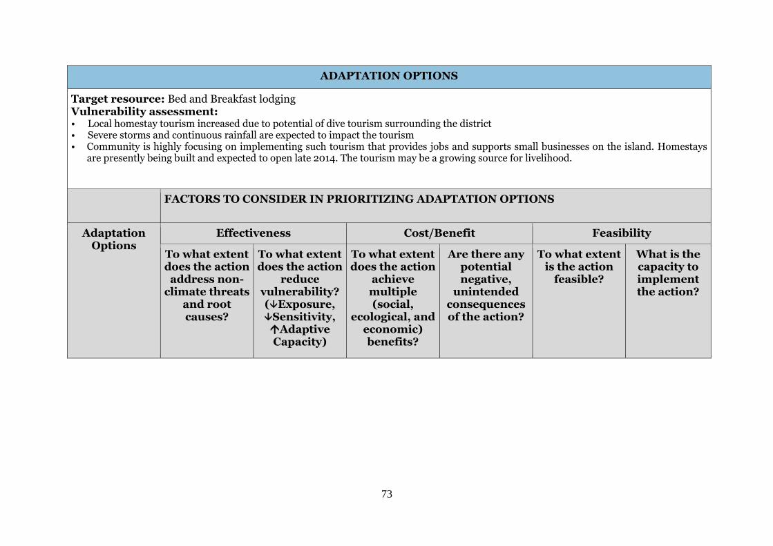
73
ADAPTATION OPTIONS
Target resource: Bed and Breakfast lodging Vulnerability assessment: • Local homestay tourism increased due to potential of dive tourism surrounding the district • Severe storms and continuous rainfall are expected to impact the tourism • Community is highly focusing on implementing such tourism that provides jobs and supports small businesses on the island. Homestays
are presently being built and expected to open late 2014. The tourism may be a growing source for livelihood.
FACTORS TO CONSIDER IN PRIORITIZING ADAPTATION OPTIONS
Adaptation Options
Effectiveness Cost/Benefit Feasibility
To what extent does the action
address non-climate threats
and root causes?
To what extent does the action
reduce vulnerability? (Exposure, Sensitivity, Adaptive Capacity)
To what extent does the action
achieve multiple (social,
ecological, and economic) benefits?
Are there any potential negative,
unintended consequences of the action?
To what extent is the action
feasible?
What is the capacity to implement the action?
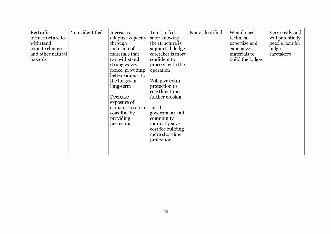
74
Restrofit infrastructure to withstand climate change and other natural hazards
None identified Increases adaptive capacity through inclusion of materials that can withstand strong waves; hence, providing better support to the lodges in long-term Decrease exposure of climate threats to coastline by providing protection
Tourists feel safer knowing the structure is supported, lodge caretaker is more confident to proceed with the operation Will give extra protection to coastline from further erosion Local government and community indirectly save cost for building more shoreline protection
None identified Would need technical expertise and expensive materials to build the lodges
Very costly and will potentially need a loan for lodge caretakers
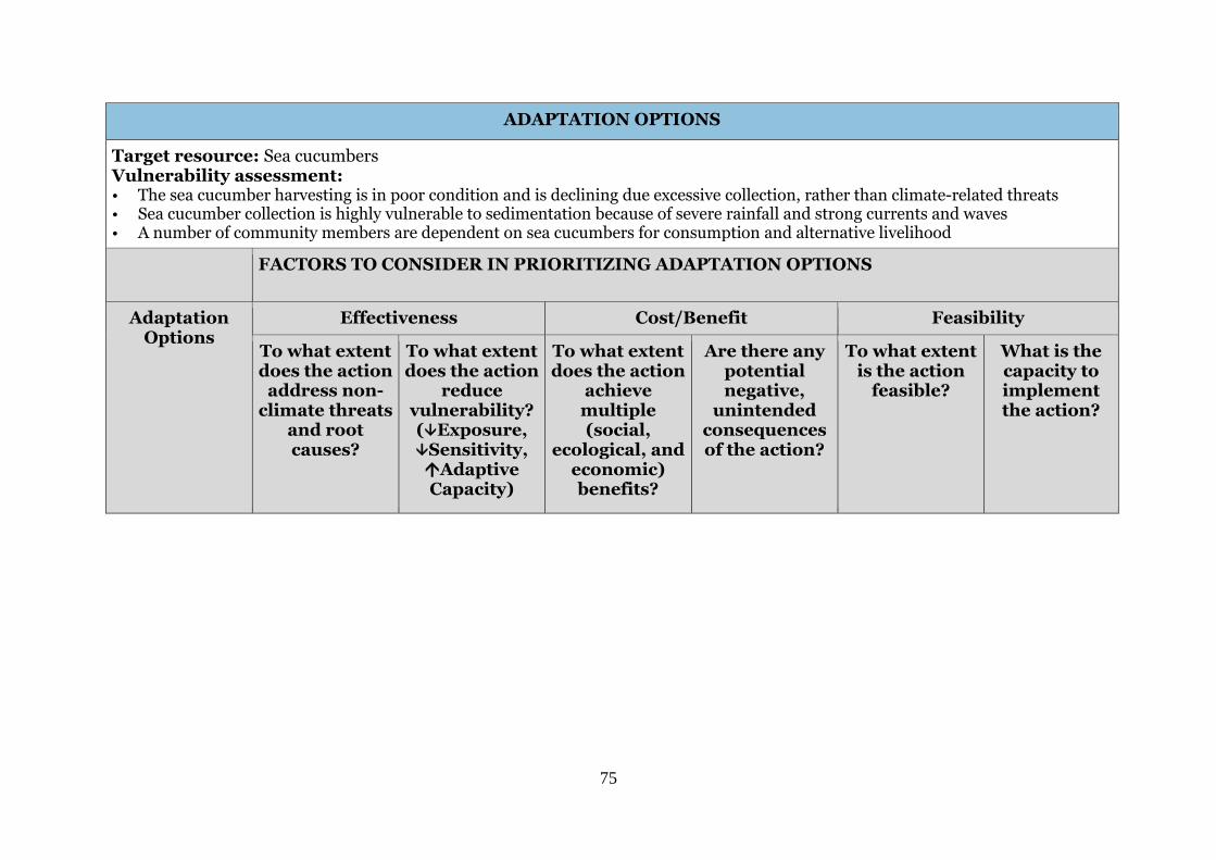
75
ADAPTATION OPTIONS
Target resource: Sea cucumbers Vulnerability assessment: • The sea cucumber harvesting is in poor condition and is declining due excessive collection, rather than climate-related threats • Sea cucumber collection is highly vulnerable to sedimentation because of severe rainfall and strong currents and waves • A number of community members are dependent on sea cucumbers for consumption and alternative livelihood
FACTORS TO CONSIDER IN PRIORITIZING ADAPTATION OPTIONS
Adaptation Options
Effectiveness Cost/Benefit Feasibility
To what extent does the action
address non-climate threats
and root causes?
To what extent does the action
reduce vulnerability? (Exposure, Sensitivity, Adaptive Capacity)
To what extent does the action
achieve multiple (social,
ecological, and economic) benefits?
Are there any potential negative,
unintended consequences of the action?
To what extent is the action
feasible?
What is the capacity to implement the action?
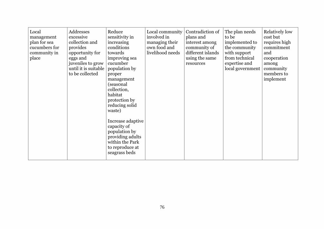
76
Local management plan for sea cucumbers for community in place
Addresses excessive collection and provides opportunity for eggs and juveniles to grow until it is suitable to be collected
Reduce sensitivity in increasing conditions towards improving sea cucumber population by proper management (seas0nal collection, habitat protection by reducing solid waste) Increase adaptive capacity of population by providing adults within the Park to reproduce at seagrass beds
Local community involved in managing their own food and livelihood needs
Contradiction of plans and interest among community of different islands using the same resources
The plan needs to be implemented to the community with support from technical expertise and local government
Relatively low cost but requires high commitment and cooperation among community members to implement