aturcara bengkel pengurusan sungai...
TRANSCRIPT
9.00 pagi Ucapan Perasmian olehY.A.B. Menteri Besar Selangor
9.30 pagi Minwn Pagi
10.00 pagi Ucapan Khas Pengurusan dan Pembangunan Sungai -Suatu Strategi ke arah Pembangunan Mampan olehKetua Setiausaha Kementerian Pertanian Aetl- (44,
Pengerusi : Dr. Halimaton Saadiah bt. Hashim ,Pengarah - JabatanPerancang Bandar dan Desa Negeri Selangor
11.00 pagi
Pembentangan Kertas Kerja dan Perbincangan di peringkatBengkel
PerundanganKewangan dan PengurusanTelmikal dan InstitusiEkologi dan Alam Sekitar
12.30 tgh Makan Tengahari dan solat zohor
2.00 petang Sambungan pembentangan kertas kerja dan perbincangandi peringlcat bengkel
4.30 iietang Minum Petang
5.00 petang Riadah dan rehat
8.00 malam Makan Malam '
9.00 malam Sambungan perbincangan bengkel
10.00 malam Minum malam
ATURCARA BENGKEL PENGURUSAN SUNGAI NEGERISELANGOR
29 Mac 1998 (Ahadl
2.00 - 3.00 petang Pendaftaran Peserta di De Palma Inn
3.30 petang Minn Petang
4.00 petang "Boat Cruise" dari Kuala Selangor keKampung Kuantan
6.45 - 7.45 malam Makan Malam di De Palma Inn
7.45 malam Lawatan ke Pusat Kelip-kelip, Kampung Kuantan,Kuala Selangor (Pengangkutan disediakan)
10.30 malani Rehat
30 Mac 1998 llsnin1
8.00 pagi Ketibaan Peserta /Pendaftaran
8.30 pagi
Ketibaan Jemputan Kehormat :Y.B. Datin Paduka Hajjah Rakibah bt. Abel. ManapY.A.B. Menteri Besar Selangor
8.35 pagi Bacaan Doa (Kadi, Kuala Selangor)
8.45 pagi Ucapan Alu-aluan olehY.B. Datin Paduka Hajjah Rakibah
a a a a 0 1 a a MN a a a a a a • a
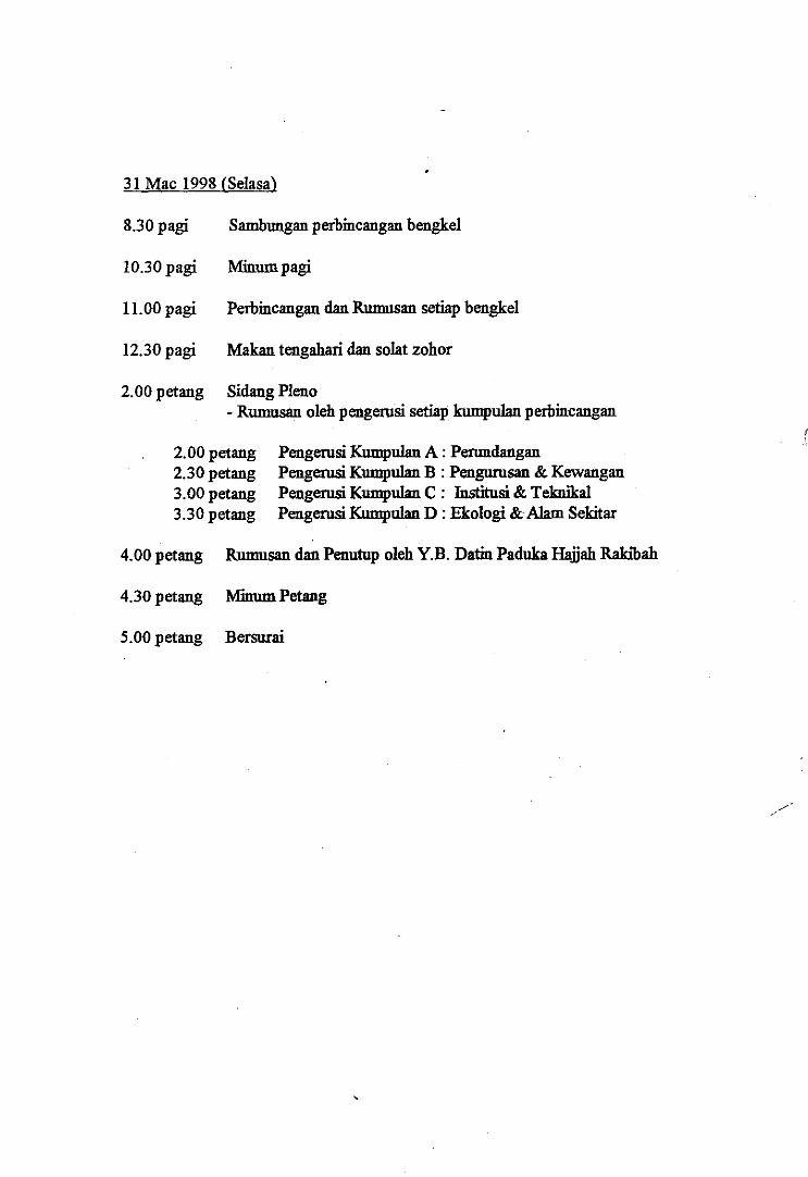
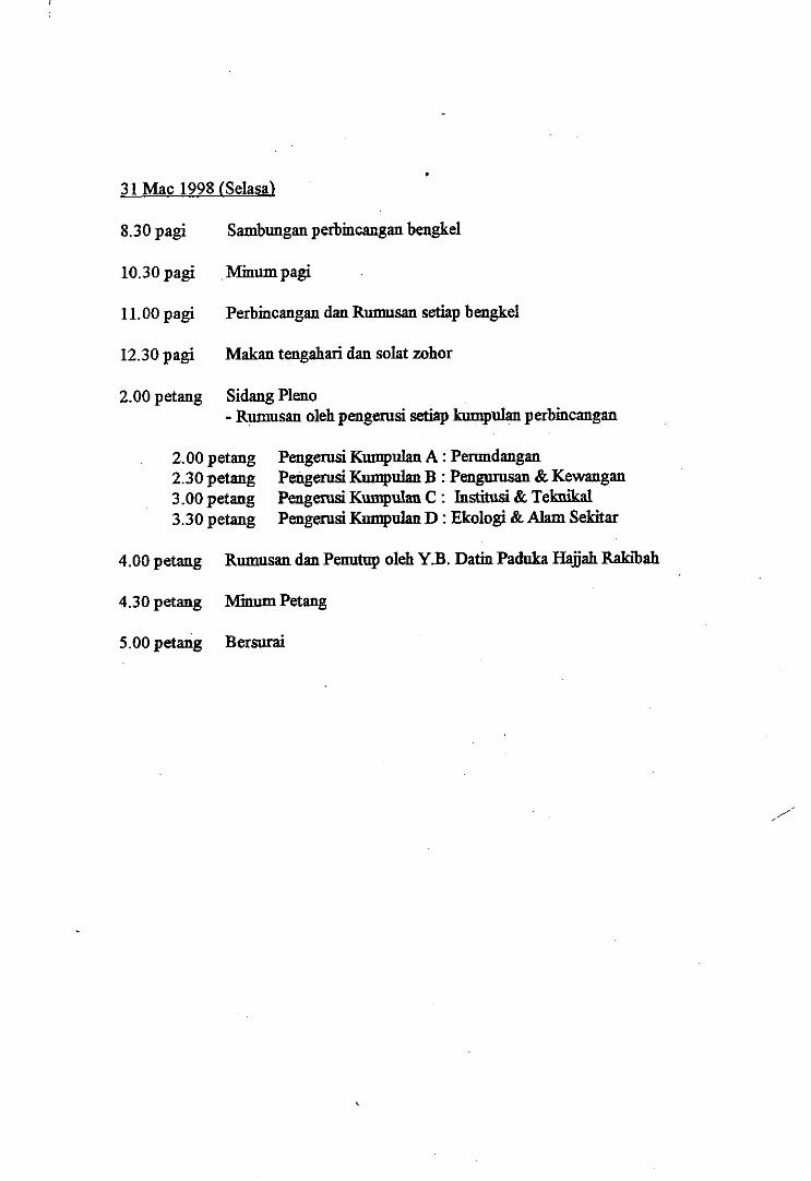
31 Mac 1998 (Selasa)
8.30 pagi Sambungan perbincangan bengkel
10.30 pagi Minum pagi
11.00 pagi Perbincangan dan Rumusan setiap bengkel
12.30 pagi Malcan tengahari dan solat zohor
2.00 petang Sidang Plano- Rumusan oleh pengerusi setiap kumpulan perbincangan
ATURCARA PERASMIAN
ICI INKEL FrEaqcSati 5qtflt NAM! 5ELNMOJA
PADA SO MAC 1998 (ISNIN)DI DE PALNIA INN, KUALA SELANGOR
Pengerusi Majlis : En. Mohd Nor Mohamed AzalliJabatan Alam Sekitar, Negeri Selangor
Pengerusi : En. Mohd. Sinon b. Mudzakir , 8.00 pagi Ketibaan PesertaTimbalan Setiausaha Kerajaan 1, Negeri Selangor
8.30 pagi Ketibaan Jemputan Dif-Dif Kehormat :4.00 petang Rumusan dan Penutup oleh Y.B. Datin Paduka Hajjah Rakibah bt. Abd. Manap
Y.B. Datin Paduka Hajjah Rakibah Y.A.B. Menteri Besar Selangor
4.30 petang Minum Petang 8.35 pagi Bacaan Doa (Kadi, Kuala Selangor)
5.00 petang Bersurai 8.45 pagi Ucapan Alu-aluan oleh Y.B. Datin Paduka Hajjah Rakibah
9.00 pagi Ucapan Perasmian oleh Y.A.B. Menteri Besar Selangor
9.30 pagi Minum Pagi
10.00 pagi Bersurai
MI MI a a MI a a a a IS I= MI =Id a a
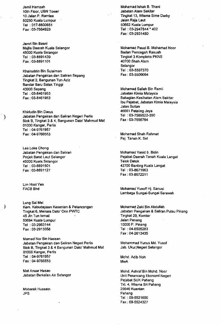
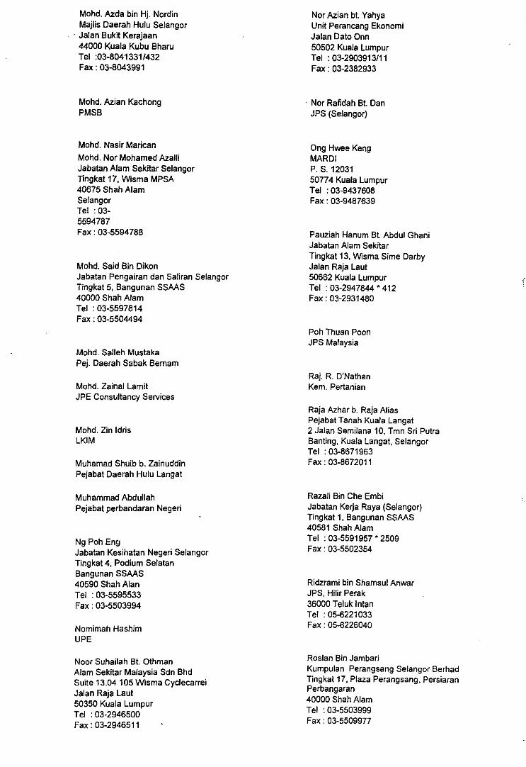
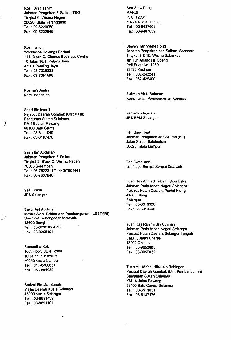
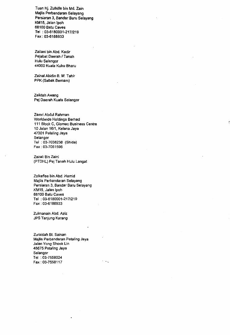
Bengkel Pengurusan Sungai Negeri Selangor29 Mac - 31 Mac 1998, De Palma Inn, Kuala Selangor
AB. Jalal Bin KasimJabatan Perhilitan Negeri SelangorTingkat 3, Blok Podium UtaraBangunan SSAAS40664 Shah AlamSelangorTel : 03-5593915Fax : 03-5501830
Abas Bin Md. YusofJabatan Pengairan dan Saliran MelakaTingkat 2, Block C, Seri NegeriJalan Hang Tuah75300 MelakaTel : 06-2921307Fax : 06-2844299
Abd. Rashid b. Hj. Abd. SatarBet Air K. Selangor
Abdul Halim Bin Abdul HamidKementerian Perumahan & Kerajaan TempatanBlok K, Paras 4 & 5Pusat Bandar DamansaraPeti Surat 1257950782 Kuala LumpurTel : 03-2852475Fax : 03-2554066
Abu Bakar AhmadJBAS
Abu Talib bin Abu BakarJOS (Gimbak)
Adam Abdul MalikVXK Group
Abdul Hamed BakinJab. Pertanian
Abdul Hamid Bin DesaBahagian Kemajuan Wilayah Persekutuan danPerancangan Lembah KelangJabatan Perdana MenteriTingkat 5, Wisma PKNSJalan Raja Laut50674 Kuala LumpurTel : 03-2922466Fax : 03-2918870
Abdul Haq B. Abd HamidMajlis Perbandaran Petaling JayaJalan Yong Shook Lin46675 Petaling JayaTel : 03-7558024Fax : 03-7558117
Abdul Majid bin MohamadPejabat Daerah Kuala Selangor
Abdullah ManjunidMaj. Perbandaran Kajang
Ahmad Rozian Bin OthmanKementerian Perumahan Dan Kerajaan TempatanBlok K, Paras 4 & 5Pusat Bandar DamansaraPeti Surat 1257950782 Kuala LumpurTel : 03-2547033Fax : 03-2547380
Ahmad Tarmizi B. BastaniJUPEM Selangor
Ahmad Fariz MohamedInstitut Alam Sekitar & Pembangunaan (LESTARI)Universiti Kebangsaan Malaysia43600 BangiSelangorTel : 03-8251000 6190/6136Fax : 03-8255104
Ahmad Fuad EmbiJPS IbuPejabat
Ahmad Md. YusofPTG
Akashah Bin Hj. MajizatJabatan Kerja RayaEnvironmental (Standard)Road Design Unit, Roads BranchJKR HQ, Jln Sultan Salahudin50582 Kuala LumpurTel : 03-4407792Fax : 03-2933160
Alinah AhmadPTG
Amin Jaya Bin Mohd. DinPej. Daerah Petaling
Appri BeyanJabatan Kimia MalaysiaBahagian Kesihatan Alam SekitarIbu Pejabat, Jabatan Kimia MalaysiaJalan Sultan46661 Petaling JayaTel :03-7569522-390Fax : 03-7556764
Chong Ing KeongJabatan Pengairan Saliran Negeri PahangTingkat 8, Bangunan KomturBandar lndera Mohkota25700 KuantanPahangTel : 09-5733966Fax : 09-5733440
Azhar Bin OthmanMajlis Perbandaran Ampang JayaMenara MPAJ, Jalan Pandan UtamaPandan Indah55100 Kuala LumpurTel : 03-4968018Fax : 03-4968050/60
Azlina Bt. Kadir MirahKumpulan Darul Ehsan BerhadTingkat 17, Plaza Perangsang, PersiaranPerbandaran40000 Shah AlamTel : 03-5503999Fax : 03-5509977
Baizura KamalPej. Penasihat Undang-Undang Selangor
Curly HumphreysMalaysian Forest Plantations50-01-10 Wisma UOA DamansaraJalan Dungun, Damansara Heights50490 Kuala LumpurTel : 03-2548901Fax : 03-2548685
Dr. Choo Moon KeongJ128 Jalan PerkasaSalak South Garden57100 Kuala LumpurTel /Fax : 9570585
Dr. Jamsiah Binti MustafaPejabat Kesihatan Daerah Hulu LangatBangunan Lee Jit Lam, Jalan Bukit43000 KajangSelangorTel : 03-8367770
Bala SubramaniamFirma Guaman @ K. Ganish & Associates272, 2nd Floor, Jln Tun Sambanthan (Brickfields)50470 Kuala LumpurTel : 03-2722611/655Fax : 03-2722699
C. PoobalanJOS (Selangor)
Che Mahamud bin Ismail •Jabatan Alam Sekitar Kedah/PerlisAras 1, Menara Zakat, Jin Teluk Wan Jah05200 Alor SetarKedahTel : 04-7332832Fax : 04-7337530
Cheah Wing ChoongTan & Tan Developments Berhad26th Floor, Menara Tan & Tan207 Jalan Tun Razak50400 Kuala LumpurTel : 03-2631111Fax : 03-2637349
Chew Tuck PengPKNS
Dr. Lee JinKTA Tenaga Sdn BhdLevel 5, Uptown 2, Damansara Uptown2 Jalan SS21/37, Damansara Utama47400 Petaling JayaSelangorTel : 03-9263333Fax : 03-9263322
Dr. Mohd Kamil YusoffJabatan Sains Alam SekitarUniversiti Putra Malaysia43400 SerdangSelangorTel :03-9486101'3576Fax : 03-9438109
Dr. Zelina Bte Zaiton IbrahimNational Hydraulic Research Institute MalaysiaKM 7 Jln Ampang, Blok A, Kompleks JPS68000 Kuala LumpurTel : 03-4564016/7Fax : 03-4564028
Dr.Joy Jacqueline PepeiraInstitut Alam Sekitar dan Pembangunan (LESTARI)Universiti Kebangsaan Malaysia43600 BangiSelangorTel : 03-8296188/61Fax : 03-8255104
Emiley Bte AdlanMajlis Perbandaran Ampang JayaMenara MPAJ, Jalan Pandan UtamaPandan lndah55100 Kuala LumpurTel : 03-4968089Fax : 03-4968080/60
Engku Mohd. Suhaimi BasriPKNS
Faizal ParishWetlands International A.P.835 Jalan 17/22CPetaling JayaTel : 03-7564929/012-3227350Fax : 03-7564929
Fatimah Md. YusoffFakulti Sains & Pengajian Alam SekitarUniversiti Putra Malaysia43400 SerdangSelangorTel : 039486010 3630Fax : 9488246
Gunilla GoranssonDANCED/EPURegional Economics Sect.6th Floor, EPU Prinne Minister Dept.Jalan Tun Onn50502 Kuala LumpurTel : 03-2382911Fax : 03-2382933
Hairuddin IsmailMajlis Perbandaran KajangHaji Amiruddin B. Hj. HashimJabatan Pengairan dan SaliranSungai Manggis42700 Banting, Kuala LangatSelangor
Hamidin B. Ahmad JudinBahagian Kemajuan Wilayah Persekutuan danPerancangan Lembah KelangJabatan Perdana MenteriTingkat 5, Wisma PKNSJalan Raja Laut50674 Kuala LumpurTel : 03-2922466Fax : 03-2918870
Hashim Bin OsmanJabatan Pengairan & SaliranKomplek Kayu Blok BJalan Tunku Kunshiah70400 SerembanTel : 06-7632448Fax : 06-7670903
Hazel CutlackMalaysian Forest Plantations50-01-10, Wisma UOA DamansaraJalan Dungun, Damansara Heights50490 Kuala LumpurTel : 03-2548901Fax : 03-2548685
Helical Bin Mohd. KamelYusuf Abdul Rahman & Co.
Hj. Ahmad Jamaluddin bin ShaabanNational Hydraulic Research Institute MalaysiaKM 7 JIn Ampang, Blok A, Kompleks JPS68000 Kuala LumpurTel : 03-4564016/7Fax : 03-4564028
Hj. Mod. Hilal RabingamPej. Daerah Gombak
Hj. Mohammad b. DensJPS Hulu Langat
Haji Md. Hilal Bin RabinganPejabat Daerah Gombak (Unit Hasil)Bangunan Sultan SulaimanKM 16 Jalan Rawang68100 Batu CavesSelangorTel : 03-6111031Fax : 03-6187476
Haji Norazmi Bin NordinBadan Pencegah RasuahTingkat 3 Kompleks PKNS40700 Shah AlamSelangorTel : 03-5597370Fax : 03-5509094
Hj. Sa'Diyah Bt. KhasimanMajlis Perbandaran Petaling JayaJalan Yong Shook Lin46675 Petaling JayaTel : 03-7558024Fax : 03-7558117
Hj. Sunan Mokhdir B. Hj. JaafarJabatan Perikanan Negeri SelangorDaerah Tanjong KarangSelangorTel : 03-8795504
Ir. Azmi bin IbrahimJabatan Pengairan dan Saliran Negeri KedahTingkat 7, Bangunan Sultan Abdul HalimJalan Sultan Badlishah05000 Slor SetarTel : 04-7333433Fax : 04-7314011
Ir. Bahazruddin bin Ahmad NasirJabatan Pengairan dan Saliran Negeri KedahTingkat 7, Bangunan Sultan Abdul HalimJalan Sultan Badlishah05000 Slor SetarTel : 04-7333433Fax : 04-7314011
Ir. Chop Ai KuangJabatan Pengairan & Saliran Wilayah PersekutuanJalan Sultan Salahuddin50626 Kuala LumpurTel : 03-2929461Fax : 03-2932285
Ir. Haji Abd. Rahim Bin KaparawiJabatan Pengairan dan Saliran MalaysiaJalan Sultan Salahuddin50626 Kuala LumpurTel : 03-2923831Fax : 03-2948268
Ir. Haji Hanapi Mohamad NoorJabatan Pengairan dan Saliran malaysiaBahagian Perancangan dan PenilaianJalan Sultan Salahuddin50626 Kuala LumpurTel : 03-2982769Fax : 03-2911082
Ir. Mohd. Azhari bin GhazaliJabatanPengairan dan Saliran MelakaTingkat 2, Block C, Bangunan Seri NegeriJalan Hang Tuah75300 MelakaTel : 06-2921300Fax : 06-2844299
Ir. Phuah Kim HengJabatan Pengairan dan Saliran MalaysiaKM7, Jalan Ampang68000 AmpangTel : 03-4565828Fax : 03-4563735
Ir. Saw Hin SeangJabatan pengairan dan Saliran MalaysiaBahagian Perancangan dan PenilaianJalan Sultan Salahuddin50626 Kuala LumpurTel : 03-2928384Fax : 03-2911082
Ir. Shukri Bin MuslimJabatan Pengairan Dan Saliran41000 KiangSelangorTel : 03-3312464Fax : 03-3324802
Ir. Tay Chong SenJabatan Pengairan dan Saliran, JohorAras 3, Bangunan Sultan Ibrahim80990 Johor BahruJohorTel : 07-2243322/63Fax : 07-2243321
Ir. Yap Siew FahJabatan Pengairan & Saliran Negeri SabahTingkat 5 & 6, Bangunan Menara KhidmatJabatan Bella88626 Kota KinabaluSabahTel : 088-436254Fax : 088-242770
Ir. Liew Chin LoongJabatan Pengairan dan Saliran Wilayah BersekutuJalan Sultan Salahuddin50626 Kuala LumpurTel : 03-2920023Fax : 03-2932285
Ir. Lim Chow HockJabatan Pengairan dan Saliran, JohorAras 3, Bangunan Sultan Ibrahim80990 Johor BahruJohorTel : 07-4322078Fax : 07-4329023
Ir. Mohd. Adib B. Haji Awang NohInter Water Industries (M) Sdn Bhd41 B Jalan Pandan 3/3, Pandan Jaya55100 Kuala LumpurTel : 03-9845227Fax : 03-9846305 -
Ismail AwangPPN. Selangor
Jalaluddin Bin IsmailJabatan Alam Sekitar SelangorTingkat 17, Wisma MPSA40675 Shah AlamSelangorTel : 03-5594787Fax : 03-5594788
Jamil Hamzah10th Floor, UBN Tower10 Jalan P. Ramlee50250 Kuala LumpurTel : 017-8800651Fax : 03-7564929
Jamri Bin BasniMajlis Daerah Kuala Selangor45000 Kuala SelangorTel : 03-8891439Fax : 03-8891101
Khairuddin Bin SulaimanJabatan Pengairan dan Saliran SepangTingkat 2, Bangunan Tun AzizBandar Baru Salak Tinggi43900 SepangTel : 03-8461953Fax : 03-8461953
Khirludin Bin DarusJabatan Pengairan dan Saliran Negeri PerlisBlok B, Tingkat 3 & 4, Bangunan Dato' Mahmud Mat01000 Kangar, PerlisTel : 04-9761957Fax : 04-9766553
Lee Loke ChongJabatan Pengairan dan SaliranProjek Barat Laut Selangor45000 Kuala SelangorTel : 03-8891501Fax : 03-8891127
Lim Hooi YenFACB Bhd
Lung Sai MeiKern. Kabudayaan Kesenian & PelanconganTingkat 6, Menara Dato' Onn PWTC45 Jln Tun Ismail50694 Kuala LumpurTel : 03-2963144Fax : 03-2913358
Mamad Nor Bin HassanJabatan Pengairan dan Saliran Negeri PerlisBlok B, Tingkat 3 & 4 Bangunan Dato' Mahmud Mat01000 Kangar, PerilsTel : 04-9761957Fax : 04-9766553
Mat Anuar HasanJabatan Berkalan Air Selangor
Mobarak HusseinJPS
Mohamad lshak B. ThaniJabatan Alam SekitarTingkat 13, Wisma Sime DarbyJalan Raja Laut50662 Kuala LumpurTel : 03-2947844 * 402Fax : 03-2931480
Mohamad Pauzi B. Mohamad NoorBadan Pencegah RasuahTingkat 3 Kompleks PKNS40700 Shah AlamSelangorTel : 03-5597370Fax : 03-5509094
Mohamad Salleh Bin RamliJabatan Kimia MalaysiaBahagian Kesihatan Alam Sekitarlbu Pejabat, Jabatan Kimia MalaysiaJalan Sultan46661 Petaling JayaTel : 03-7569522-390Fax : 03-7556764
Mohamad Shah RahmatPej. Tanah K. Sel
Mohamad Yasid b. BidinPejabat Daerah Tanah Kuala LangatTelok Datok42700 Banting Kuala LangatTel : 03-8671963Fax : 03-8672011
Mohamad Yusoff Hj. SanusiLembaga Sungai-Sungai Sarawak
Mohamad Zaki Bin AbdullahJabatan Pengairan & Saliran Pulau PinangTingkat 29, KomtarJalan Penang10000 P. PinangTel : 04-6505283Fax : 04-2613435
Mohammad Yunus Md. YusofJab. Ukuitlegeri Selangor
Mohd. Adib NohMwA
Mohd. Ashraf Bin Mohd. NoonUnit Perancang Ekonomi NegeriPejabat SUK PahangTkt. 4, Wisma Sri Pahang25646 KuantanPahangTel : 09-5521600Fax : 09-5524327
Mohd. Azda bin Hj. NordinMaps Daerah Hulu SelangorJalan Bukit Kerajaan44000 Kuala Kubu BharuTel :03-8041331/432Fax : 03-8043991
Nor Azian bt. YahyaUnit Perancang EkonomiJalan Dato Onn50502 Kuala LumpurTel : 03-2903913/11Fax : 03-2382933
I,
Mohd. Azian Kachong Nor Rafidah Bt. DanPMSB
JPS (Selangor)
Mohd. Nasir MaricanMohd. Nor Mohamed AzalliJabatan Alam Sekitar SelangorTingkat 17, Wisma MPSA40675 Shah AlamSelangorTel : 03-5594787Fax : 03-5594788
Mohd. Said Bin DikonJabatan Pengairan dan Saliran SelangorTingkat 5, Bangunan SSAAS40000 Shah AlamTel : 03-5597814Fax : 03-5504494
Mohd. Salleh MustakaPej. Daerah Sabak Bernam
Mohd. Zainal LamitJPE Consultancy Services
Mohd. Zin IdrisLKIM
Muhamad Shuib b. ZainuddinPejabat Daerah Hulu Langat
Muhammad AbdullahPejabat perbandaran Negeri
Ng Poh EngJabatan Kesihatan Negeri SelangorTingkat 4, Podium SelatanBangunan SSAAS40590 Shah AlanTel : 03-5595533Fax : 03-5503994
Nomimah HashimUPE
Noor Suhailah Bt. OthmanAlam Sekitar Malaysia Sdn BhdSuite 13.04 105 Wisma CyclecarreiJalan Raja Laut50350 Kuala LumpurTel : 03-2946500Fax : 03-2946511 •
Ong Hwee KengMARDIP. S. 1203150774 Kuala LumpurTel : 03-9437608Fax : 03-9487639
Pauziah Hanum Bt. Abdul GhaniJabatan Alam SekitarTingkat 13, Wisma Sime DarbyJalan Raja Laut50662 Kuala LumpurTel : 03-2947844 * 412Fax : 03-2931480
Poh Thuan PoonJPS Malaysia
Raj. R. D'NathanKern. Pertanian
Raja Azhar b. Raja AliasPejabat Tanah Kuala Langat2 Jalan Semilana 10, Tmn Sri PutraRanting, Kuala Langat, SelangorTel : 03-8671963Fax : 03-8672011
Razali Bin Che EmbiJabatan Kerja Raya (Selangor)Tingkat 1, Bangunan SSAAS40581 Shah AlamTel : 03-5591957 2509Fax : 03-5502354
Ridzrami bin Shamsul AnwarJPS, Hilir Perak36000 Teluk IntanTel : 05-6221033Fax : 05-6226040
Roslan Bin JambariKumpulan Perangsang Selangor BerhadTingkat 17, Plaza Perangsang, PersiaranPerbangaran40000 Shah AlamTel : 03-5503999Fax : 03-5509977
Rosh Bin HashimJabatan Pengairan & Saliran TRGTingkat 6, Wisma Negeri20626 Kuala TerengganuTel : 09-6220050Fax : 09-6232646
Rosli IsmailWorldwide Holdings Berhad111, Block C, Glomac Business Centre10 Jalan 16/1, Kelana Jaya47301 Petaling JayaTel : 03-7038238Fax : 03-7051596
Soo Siew PengMARDIP. S. 1203150774 Kuala LumpurTel : 03-9437608Fax : 03-9487639
Steven Tan Weng HongJabatan Pengairan dan Saliran, SarawakTingkat 9 & 10, Wisma SaberkasJln Tun Abang Hj. OpengPeti Surat No 123093626 KuchingTel : 082-243241Fax : 082-426400
Rosmah JentraKern. Pertanian
Saad Bin IsmailPejabat Daerah Gombak (Unit Hasil)Bangunan Sultan SulaimanKM 16 Jalan Rawang68100 Batu CavesTel : 03-6111049Fax : 03-6187476
Saari Bin AbdullahJabatan Pengairan & SaliranTingkat 2, Block C, Wisma Negeri70503 SerembanTel : 06-7622311 * 1443/7601441Fax : 06-7637840
Safii RamliJPS Selangor
Saiful Arif AbdullahInstitut Alam Sekitar dan Pembangunan (LESTARI)Universiti Kebangsaan Malaysia43600 BangiTel : 03-8296188/6163Fax : 03-8255104
Samantha Kok10th Floor, UBN Tower10 Jalan P. Ramlee50250 Kuala LumpurTel : 017-8800651Fax : 03-7564929
Sarizal Bin Mat SanahMajlis Daerah Kuala Selangor45000 Kuala SelangorTel : 03-8891439Fax : 03-8891101
Suliman Abd. RahmanKem. Tanah Pembangunan Koperasi
Tarmidzi SapwaniJPS BPM Selangor
Teh Siew KeatJabatan Pengairan dan Saliran (KL)Jalan Sultan Salahuddin50626 Kuala Lumpur
Teo Swee AnnLembaga Sungai-Sungai Sarawak
Tuan Haji Ahmad Fekri Hj. Abu BakarJabatan Perhutanan Negeri SelangorPejabat Hutan Daerah, Pantai Klang41000 KlangSelangorTel : 03-3316326Fax : 03-3314496
Tuan Haji Rahimi Bin OthmanJabatan Perhutanan Negeri SelangorPejabat Hutan Daerah, Selangor TengahBatu 7, Jalan Cheras43200 CherasTel : 03-9052885Fax : 03-9056022
Tuan Hj. Mohd. Hilal bin RabinganPejabat Daerah Gombak (Unit Pembangunan)Bangunan Sultan SulamanKM 16 Jalan Rawang68100 Bath Caves, SelangorTel : 03-6111031Fax : 03-6187476
Tuan Hj. Zulkifle bin Md. ZainMajlis Perbandaran SelayangPersiaran 3, Bandar Baru SelayangKM15, Jalan 1poh68100 Batu CavesTel : 03-6180001-217/219Fax : 03-6188933
Zailani bin Abd. KadirPejabat Daerah / TanahHulu Selangor44000 Kuala Kubu Bharu
Zainal Abidin B. M. TahirPPK (Sabak Bernam)
Zalidah AwangPej Daerah Kuala Selangor
Zamri Abdul RahmanWorldwide Holdings Berhad111 Block C, Glomac Business Centre10 Jalan 16/1, Kelana Jaya47301 Petaling JayaSelangorTel : 03-7038238 (Shida)Fax : 03-7051596
Zazali Bin Zaini(PTDHL) Pej Tanah Hulu Langat
Zolkeflee bin Abd. HamidMajlis Perbandaran SelayangPersiaran 3, Bandar Baru SelayangKM15, Jalan 1poh68100 Batu CavesTel : 03-6180001-217/219Fax : 03-6188933
Zulmanain Abd. AzizJPS Tanjung Karang
Zuraidah Bt. SainanMajlis Perbandaran Petaling JayaJalan Yong Shook Lin46675 Petaling JayaSelangorTel : 03-7558024Fax : 03-7558117
I
W W P MALAYSIARESOURCE CEN't RE
Accession no.: 60 14061 G)
Date: 2 6 JUN 2000
Donated by: CrYlknoraliM co,hyteaf-
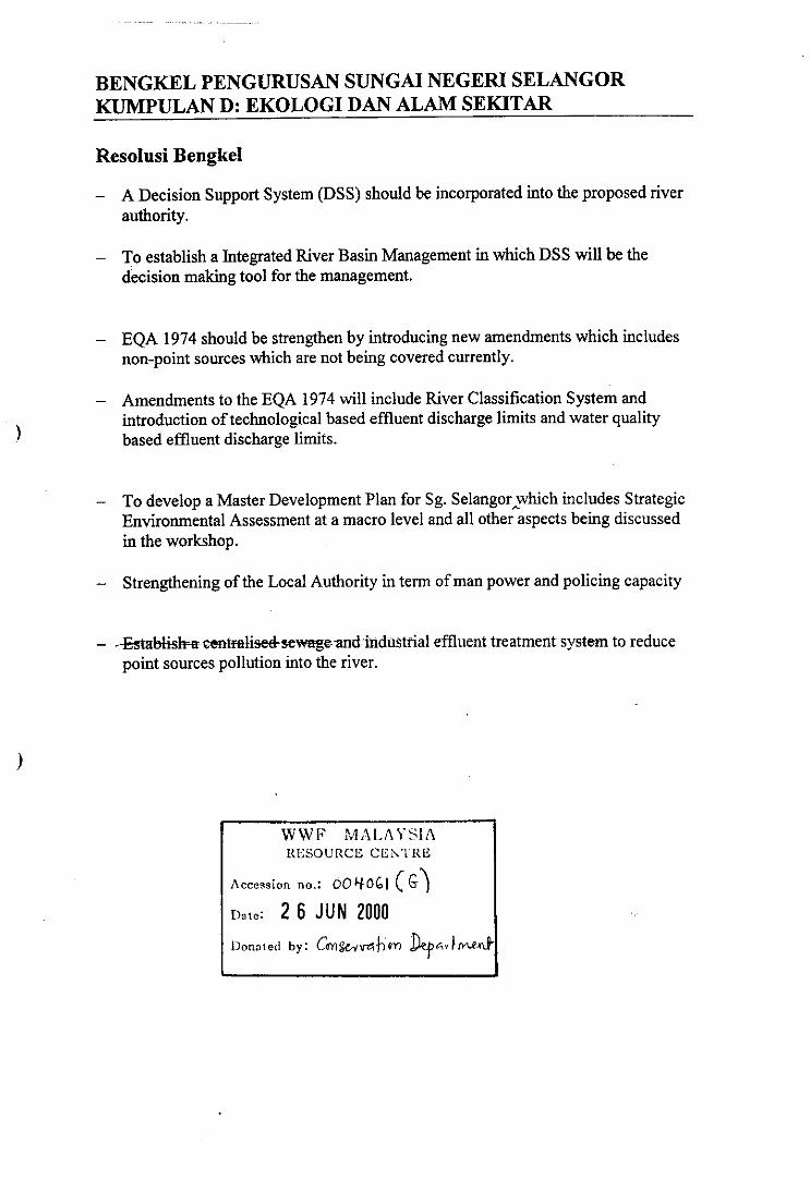
BENGKEL PENGURUSAN SUNGAI NEGERI SELANGORKUMPULAN D: EKOLOGI DAN ALAM SEKITAR
Resolusi Bengkel
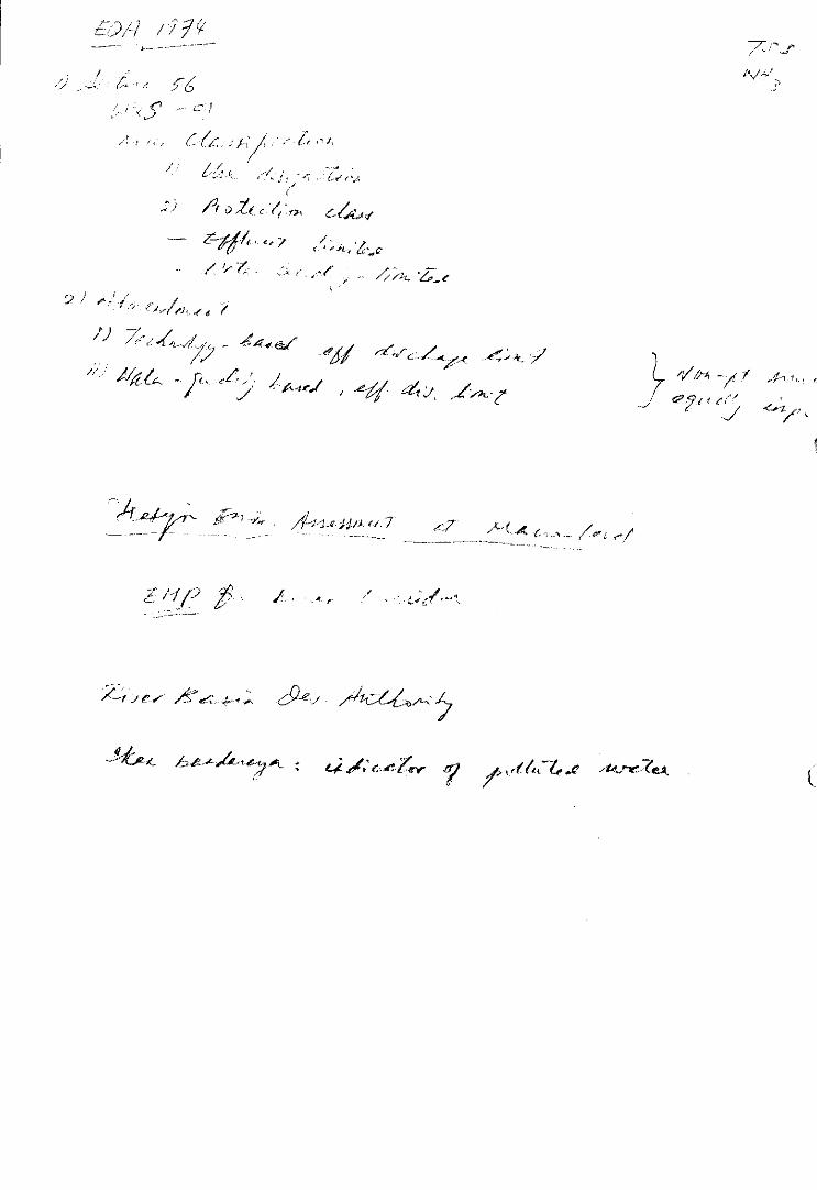
A Decision Support System (DSS) should be incorporated into the proposed riverauthority.
To establish a Integrated River Basin Management in which DSS will be thedecision making tool for the management.
EQA 1974 should be strengthen by introducing new amendments which includesnon-point sources which are not being covered currently.
Amendments to the EQA 1974 will include River Classification System andintroduction of technological based effluent discharge limits and water qualitybased effluent discharge limits.
To develop a Master Development Plan for Sg. Selangor whichincludes StrategicEnvironmental Assessment at a macro level and all other aspects being discussedin the workshop.
Strengthening of the Local Authority in term of man power and policing capacity
-Establishn centralised-sewage-and industrial effluent treatment system to reducepoint sources pollution into the river.
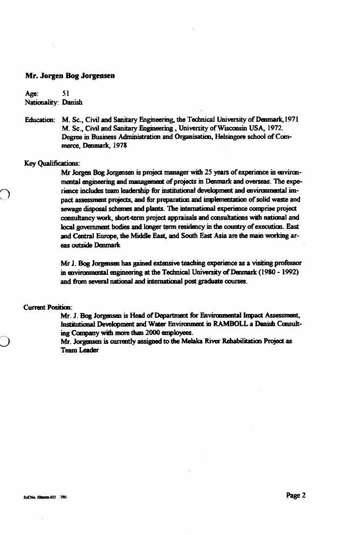
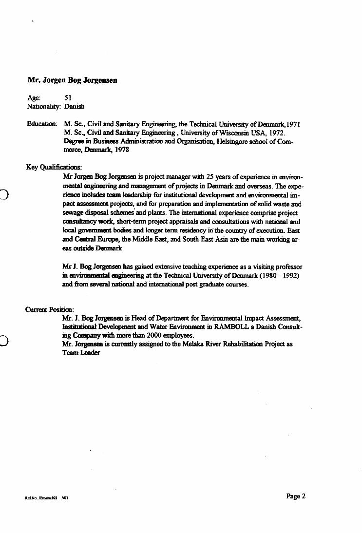
Mr. Jorgen Bog Jorgensen
Age: 51Nationality: Danish
Education: M. Sc., Civil and Sanitary Engineering„ the Technical University of Demnark,1971M. Sc., Civil and Sanitary Engineering , University of Wisconsin USA, 1972.Degree in Business Administration and Organisation, Hebingore school of Com-merce, Denmark, 1978
Key Qualifications:Mr Jorgen Bog Jorgensen is project manager with 25 years of experience in environ-mental engineering and management of projects in Denmark and overseas. The expe-rience includes team leadership for institutional development and environmental im-pact assessment projects, and for preparation and implementation of solid waste andsewage disposal schemes and plants. The international experience comprise projectconsultancy work, short-term project appraisals and consultations with national andlocal government bodies and longer term residency in the country of execution Eastand Central Europe, the Middle East, and South East Asia are the main working ar-eas outside Denmark
Mr J. Bog Jorgensen has gained extensive teaching experiarce as a visiting professorin environmental engineering at the Technical University of Denmark (1980 - 1992)and from several national and international post graduate courses.
Current Position:Mr. J. Bog Jorgensen is Head of Department for Environmental Impact Assessment,Institutional Development and Water Environment in RAMBOLL a Danish Consult-ing Company with more than 2000 employees.Mr. Jorgensen is currently assigned to the Melt River Rehabilitation Project asTeam Leader
Ref tio. Ma= MI Page 2
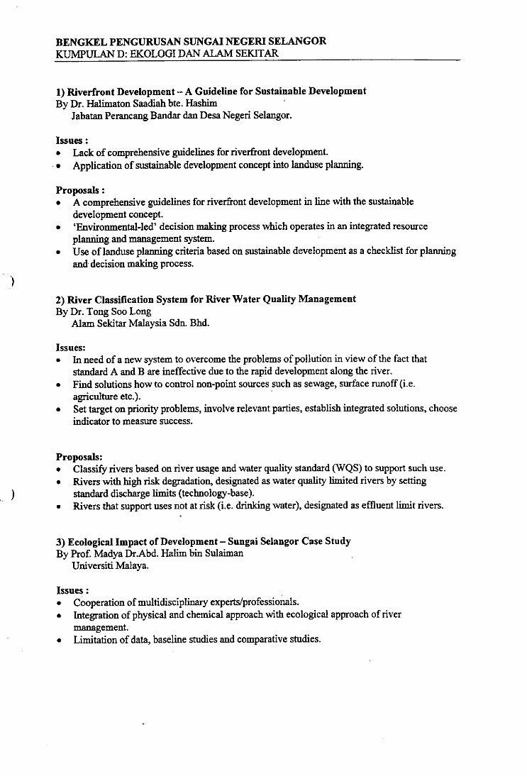
BENGKEL PENGURUSAN SUNGAI NEGERI SELANGORKUMPULAN D: EKOLOGI DAN ALAM SEKITAR
1) Riverfront Development — A Guideline for Sustainable DevelopmentBy Dr. Halimaton Saadiah bte. Hashim
Jabatan Perancang Bandar dan Desa Negeri Selangor.
Issues :Lack of comprehensive guidelines for riverfront development.Application of sustainable development concept into landuse planning.
Proposals :A comprehensive guidelines for riverfront development in line with the sustainabledevelopment concept.'Environmental-led' decision making process which operates in an integrated resourceplanning and management system.Use of landuse planning criteria based on sustainable development as a checklist for planningand decision making process.
2) River Classification System for River Water Quality ManagementBy Dr. Tong Soo Long
Alam Sekitar Malaysia Sdn. Bhd.
Issues:In need of a new system to overcome the problems of pollution in view of the fact thatstandard A and B are ineffective due to the rapid development along the river.Find solutions how to control non-point sources such as sewage, surface runoff (i.e.agriculture etc.).Set target on priority problems, involve relevant parties, establish integrated solutions, chooseindicator to measure success.
Proposals:Classify rivers based on river usage and water quality standard (WQS) to support such use.Rivers with high risk degradation, designated as water quality limited rivers by settingstandard discharge limits (technology-base)Rivers that support uses not at risk (i.e. drinking water), designated as effluent limit rivers.
•
3) Ecological Impact of Development — Sungai Selangor Case StudyBy Prof. Madya Dr.Abd. Halim bin Sulaiman
Universiti Malaya.
Issues :Cooperation of multidisciplinary experts/professionals.Integration of physical and chemical approach with ecological approach of rivermanagement.Limitation of data, baseline studies and comparative studies.
• re
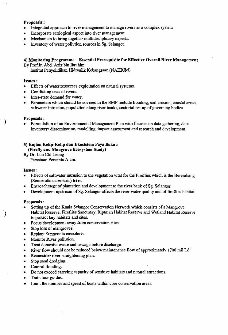
Proposals :Integrated approach to river management to manage rivers as a complex systemIncorporate ecological aspect into river managementMechanism to bring together multidisciplinary experts.Inventory of water pollution sources in Sg. Selangor.
4) Monitoring Programme — Essential Prerequisite for Effective Overall River ManagementBy Profit Abd. Aziz bin Ibrahim
Institut Penyelidikan Hidraulik Kebangsaan (NAHRIM)
Issues :Effects of water resources exploitation on natural systems.Conflicting uses of rivers.Inter-state demand for water.Parameters which should be covered in the EMP include flooding, soil erosion, coastal areas,saltwater intrusion, population along river banks, sectorial set-up of governing bodies.
Proposals :Formulation of an Environmental Management Plan with focuses on data gathering, datainventory/ dissemination, modelling, impact assessment and research and development.
5) Kajian Kelip-Kelip dan Ekosistem Paya Bakau(Firefly and Mangrove Ecosystem Study)
By Dr. Loh Chi LeongPersatuan Pencinta Alam.
Issues :Effects of saltwater intrusion to the vegetation vital for the Fireflies which is the Berembang(Sonneratia caseolaris) trees.Encroachment of plantation and development to the river bank of Sg. Selangor.Development upstream of Sg. Selangor affects the river water quality and of fireflies habitat.
Proposals :Setting up of the Kuala Selangor Conservation Network which consists of a MangroveHabitat Reserve, Fireflies Sanctuary, Riparian Habitat Reserve and Wetland Habitat Reserveto protect key habitats and sites.Focus development away from conservation sites.Stop loss of mangroves.Replant Sonneratia caseolaris.Monitor River pollution.Treat domestic waste and sewage before discharge.River flow should not be reduced below maintenance flow of approximately 1700 mil Le .Reconsider river straightening plan.Stop sand dredging.Control flooding.Do not exceed carrying capacity of sensitive habitats and natural attractions.Train tour guides.Limit the number and speed of boats within core conservation areas.
?-r Xez
III
LII
„fatte —Le*
._2(11q,c t tri art _ter /46„e6,-4-cfi
, • e,e,11'—'
7-ivAr,
I
III
/K • Lee:,
,;) A 0 e e/...e“Av
/
9 / t-[ ( _ -444(V ex/ eictc-74, 47 /177
/i 3/47, _t. ez) / ac,),I
/V&A c e,-
n//CP C I e (/'
I? /142-ye 7 42.7 A-(, e,,
I
IIIII
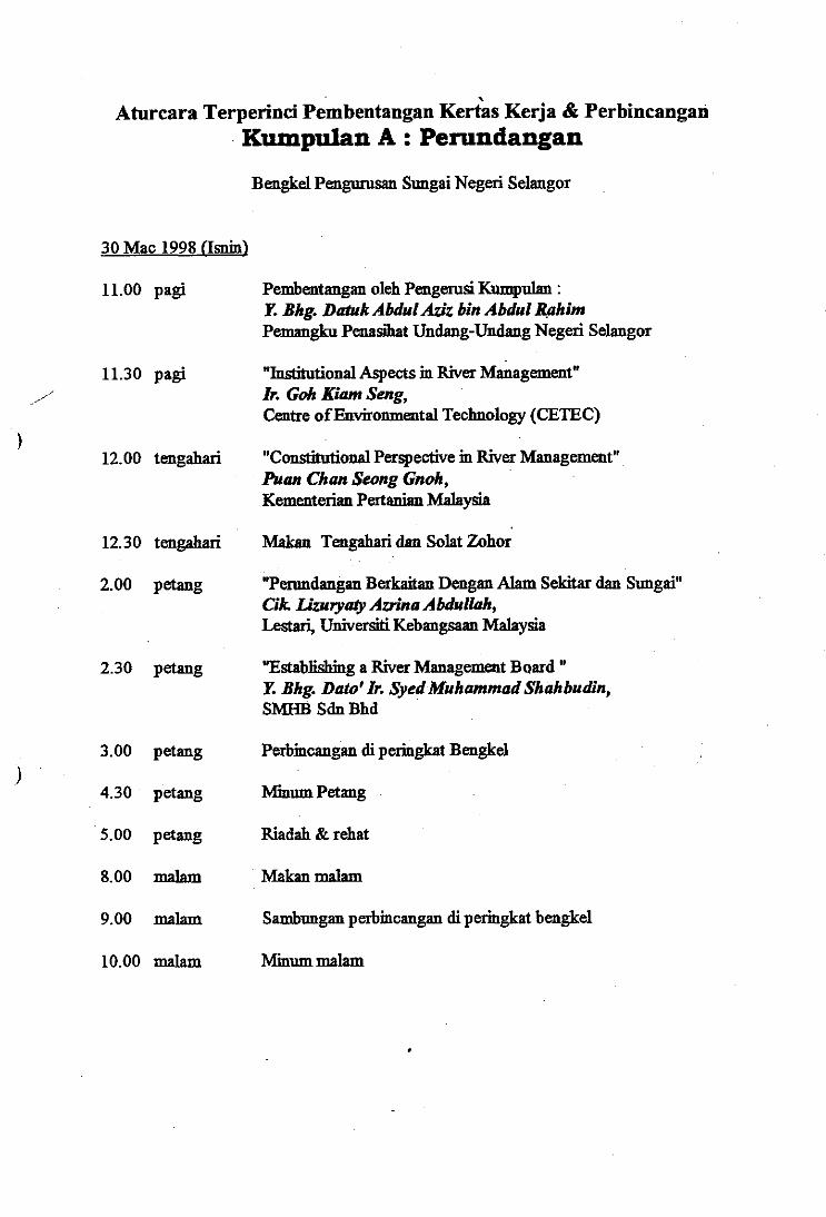
Aturcara Terperinci Pembentangan Kertas Kerja & PerbincanganKumpulan A : Perundangan
Bengkel Pengurusan Sungai Negeri Selangor
30 Mac 1998 (Int)
11.00 pagi
11.30 pagi
12.00 tengahari
Pembentangan oleh Pengerusi Kumpuhm :Y. Bhg. Datuk Abdul Aziz bin Abdul RahimPemangku Penasihat Undang-Undang Negeri Selangor
"Institutional Aspects in River Management"Ir. Goh Elam Seng,Centre of Environmental Technology (CETEC)
"Constitutional Perspective in River Management"Puan Chan Seong Gnoh,Kementerian Pertanian Malaysia
12.30 tengahari Makan Tengahari dan Solat Zohor
2.00 petang "Perundangan Berkaitan Dengan Alam Sekitar dan Sungai"Cik. Lizuryaty Azrina Abdullah,Lestari, Universiti Kebangsaan Malaysia
2.30 petang "Establishing a River Management Board "
Y. Bhg. Dato' Ir. Syed Muhammad Shahbudin,SMHB Sdn Bhd
3.00 petang Perbincangan di peringkat Bengkel
4.30 petang /vfmum Petang
5.00 petang Riadah & rehat
8.00 malam Makan malam
9.00 malam Sambungan perbincangan di peringkat bengkel
10.00 malam himum malam
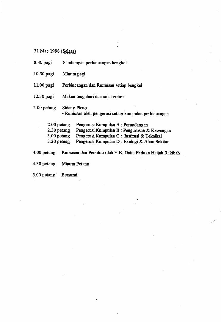
31 Mac 1998 (Selasa)
8.30 pagi Sambungan perbincangan bengkel
10.30 pagi Minum pagi
11.00 pagi Perbincangan dan Rumusan setiap bengkel
12.30 pagi Makan tengahari dan solat zohor
2.00 petang Sidang Plano- Rumusan oleh pengerusi setiap kumpulan perbincangan
2.00 petang2.30 petang3.00 petang3.30 petang
Pengerusi Kumpulan A : PenmdanganPengerusi Kumpulan B : Pengurusan & KewanganPengerusi Kumpulan C : Institusi & TeknikalPengerusi Kumpulan D : Ekologi & Alam Sekitar
4.00 petang Rumusan dan Penutup oleh Y.B. Datin Paduka Hajjah Rakibah
4.30 petang Isimum Petang
5.00 petang Bersurai
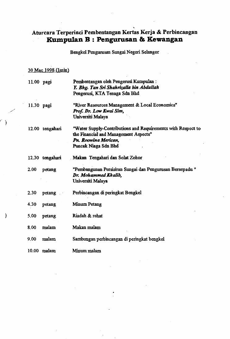
Aturcara Terperinci Pembentangan Kertas Kerja & PerbincanganKumpulan B : Pengurusan & Kewangan
Bengkel Pengurusan Sungai Negeri Selangor
12.00 tengahari
Pembentangan oleh Pengerusi Kumpulan :Y. Bhg. Tan Sri Shahrizalla bin AbdullahPengerusi, KTA Tenaga Sdn Bhd
"River Resources Management & Local Economics"Prof Dr. Low Kwai Sim,Universiti Malaya
'Water Supply-Contributions and Requirements with Respect tothe Financial and Management Aspects"Pn. Roowina Merican,Puncak Niaga Sdn Bhd
30 Mac 1998 (Isnin)
11.00 pagi
11.30 pagi
12.30 tengahari Makan Tengahari dan Solat Zohor
2.00 petang
"Pembangunan Persisiran Sungai dan Pengurusan Bersepadu "Dr. Mohammed Khalib,Universiti Malaya
2.30 petang Perbincangan di peringkat Bengkel
4.30 petang /vimurn Petang
5.00 petang Riadah & rehat
8.00 malam Makan malam
9.00 malam Sambungan perbincangan di peringkat bengkel
10.00 malam Kmum malam
31 Mac 1998 (Selasa)
8.30 pagi
10.30 pagi
11.00 pagi
12.30 pagi
2.00 petang
Sambungan perbincangan bengkel
Minuet pagi
Perbincangan dan Rumusan setiap bengkel
Makan tengahari dan solat zohor
Sidang Pleno- Rumusan oleh pengerusi setiap kumpulan perbincangan
2.00 petang Pengerusi Kumpulan A : Perundangan2.30 petang Pengerusi Kumpulan B : Pengurusan & Kewangan3.00 petang Pengerusi Kumpulan C : Institusi & Teknikal3.30 petang Pengerusi Kumpulan D : Ekologi & Alam Sekitar
4.00 petang Rumusan dan Penutup oleh Y.B. Datin Paduka Hajjah Rakibah
4.30 petang Minuet Petang
5.00 petang Bersurai
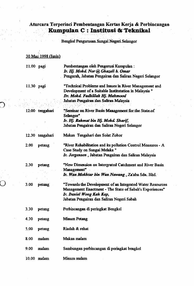
Aturcara Terperinci Pembentangan Kertas Kerja & PerbincanganKumpulan C : Institusi Teknikal
Bengkel PengumsariStelangor
Pembentangan oleh Pengerusi Kumpulan :Ir. Hj. MohcL Nor @ Ghazali b. OmarPengarah, Jabatan Pengairan dan Saliran Negeri Selangor
"Technical Problems and Issues in River Management andDevelopment of a Suitable Institutation in Malaysia "Dr. Moist Fadhlilah K. MahmoodJabatan Pengairan dan Salim Malaysia
"Seminar on River Basin Managementfor the State ofSelangor"Ir. Hj. Rahmat bin Hj. MohcL Sharif,Jabatan Pengairan dan Saliran Negeri Selangor
30 Mac 1998 (Isnin)
11.00 pagi
11.30 pagi
12:00 tengahari
12.30 tengahari Makan Tengahari dan Solat Zohor
10
2.00 petang
2.30 petang
3.00 petang
"River Rehabilitation and its pollution Control Measures - ACase Study on Sungai Melaka "Ir. Jorgensen , Jabatan Pengairan dan Saliran Malaysia
"New Dimension on Intergrated Catchment and River BasinManagement"Ir. Wan lifokhtar bin Wan Nawang , Zalaba St. Bhd.
"Towards4he Development of an Integrated Water ResourcesManagement Enactment - The State of Sabah's Experiences"Ir. Daniel Wong Rah Rap,Jabatan Pengairan dan Saliran Negeri Sabah
3.30 petang Perbincangan di peringkat Bengkel
4.30 petang Minum Petang
5.00 petang Riadah & rehat
8.00 malam Makan malam
9.00 malam Sambungan perbincangan di peringkat bengkel
10.00 malam Minum malam
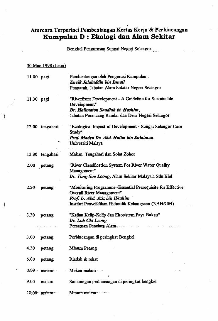
Aturcara Terperinci Pembentangan Kertas Kerja & PerbincanganKumpulan D : Ekologi dan Alam Sekitar
Bengkel pengunisan Sungai Negeri Selangor
11.30 pagi
12.00 tengahari
4;
Pembentangan oleh Pengerusi Kumpulan :Encik Jalahtddin bin IsmailPengarah, Jabatan Alam Sekitar Negeri Selangor
"Riverfront Development - A Guideline for SustainableDevelopment"Dr. Halimaton Saadiah bt. Haskim,Jabatan Perancang Bandar dan Desa Negeri Selangor
"Ecological Impact of Development - Sungai Selangor CaseStudy"Prof Madya Dr. AM Halim bin Suleiman,Universiti Malaya
30 Mac 1998 (Igain)
11.00 pagi
12.30 tengahari Makan Tengahari dan Solat Zohor
2.00 petang
2.30 petang
3.30 petang
"River Classification System For River Water QualityManagement"Dr. Tong Soo Loong, Alam Sekitar Malaysia Sdn Bhd
"Monitoring Programme -Essential Prerequisite for EffectiveOverall River Management"Prof Ir. AM Aziz bin Ibiahim "Institut Penyefidikan Ifidraua Kebangsaan (NANKIN')
"Kajian Kelip-Kefip dan Ekosistem Paya Bakau"Dr. Loh Chi LeongParcatosu P,eucinta
3.00 petang Perbincangan di peringkat Bengkel
4.30 petang himum Petang
5.00 petang Riadah & rehat
&De malam Makan malam
9.00 malam Sambungan perbincangan di peringkat bengkel
10:00• malam IVfmtma malam.
31 Mac 1998 (Selasa)
8.30 pagi Sambungan perbincangan bengkel
I
10.30 pagi
11.00 pagi
12.30 pagi
2.00 petang
2.002.303.003.30
4.00 petang
4.30 petang
5.00 petang
Minum pagi
Perbincangan dan Rumusan setiap bengkel
Makan tengahari dan solat zohor
Sidang Pleno- Rumusan oleh pengerusi setiap kumpulan perbincangan
Rumusan dan Penutup oleh Y.B. Datin Paduka Hajjah Rakibah
Minum Petang
Bersurai
petang Pengerusi Kumpulan A : Perundanganpetang Pengerusi Kumpulan B : Pengurusan & Kewanganpetang Pengerusi Kumpulan C : Instinksi & Teknikalpetang Pengerusi ICurnpulan D : Ekologi & Akin Sekitar
I
I1II
0
Mr. Jorgen Bog Jorgensen
Age: 51Nationality: Danish
Education: M Sc , Civil and Sanitary Engineering, the Technical University of Denmark,1971M. Sc., Civil and Sanitary Engineering , University of Wisconsin USA, 1972.Degree in Business Administration and Organisation, Helsingore school of Com-merce, Denmark, 1978
Key Qualifications:Mr Jorgen Bog Jorgensen is project manager with 25 years of experience in environ-mental engineering and management of projects in Denmark and overseas. The expe-rience includes team leadership for institutional development and environmental im-pact assessment projects, and for preparation and implementation of solid waste andsewage disposal schemes and plants. The international experience comprise projectconsultancy work, short-term project appraisals and consultations with national andlocal government bodies and longer term residency in the country of execution. Eastand Central Europe, the Middle East, and South East Asia are the main working ar-eas outside Denmark
Mr J. Bog Jorgensen has gained extensive teaching experience as a visiting professorin environmental engineering at the Technical University of Denmark (1980 - 1992)and from several national and international post graduate courses.
Current Position:Mr. J. Bog Jorgensen is Head of Department for Environmental Impact Assessment,Institutional Development and Water Environment in RAMBOLL a Danish Consult-ing Company with more than 2000 employees.Mr. Jorgensen is currently assigned to the Melaka River Rehabilitation Project asTeam Leader
RdNo. 1Bancm.022 .V01 Page 2
NM INS MI MI IIIIII NM UM MI Si MB MIIII OM NM a OM • • Mir
THE IMPORTANCE OF A PROPERRIVER MANAGEMENT SYSTEM TOWARDS THE
ENHANCEMENT OF THE DRINKING WATER
SELANGOR RIVER MANAGEMENT WORKSHOP29TH — 31 sT MARCH 1998
WORKING PAPER PRESENTED BY :• PUNCAK NIAGA HOLDINGS BHD
The Importance of the Proper River Management System Towards the Enhancement of the Drinking Wai
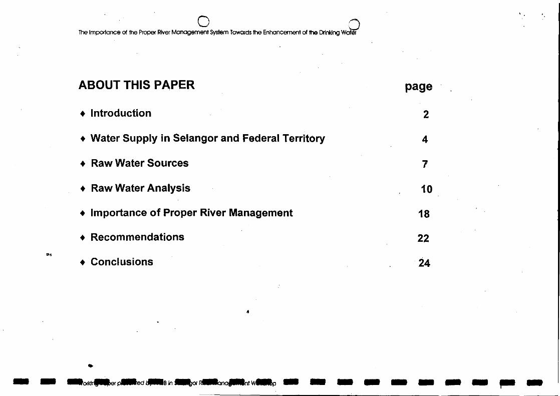
ABOUT THIS PAPER page
Introduction 2
Water Supply in Selangor and Federal Territory 4
Raw Water Sources 7
Raw Water Analysis 10
Importance of Proper River Management 18
Recommendations 22
Conclusions 24
•aodd nor palled al in intor acinaant vvelleEn a a a a a a 11111
SIM In Me a Inn Alle a a a a a Ma In 1111. a 1/111
N.)The Importance of the Proper River Management System Towards the Enhancement of the Drinking Water
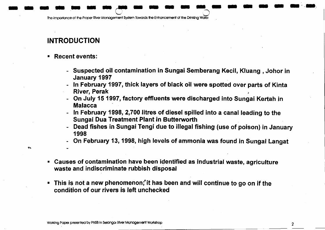
INTRODUCTION
Recent events:
Suspected oil contamination in Sungai Semberang Kecil, Kluang , Johor inJanuary 1997In February 1997, thick layers of black oil were spotted over parts of KintaRiver, PerakOn July 15 1997, factory effluents were discharged into Sungai Kertah inMalaccaIn February 1998, 2,700 litres of diesel spilled into a canal leading to theSungai Dua Treatment Plant in ButterworthDead fishes in Sungai Tengi due to illegal fishing (use of poison) in January1998On February 13, 1998, high levels of ammonia was found in Sungai Langat
Causes of contamination have been identified as industrial waste, agriculturewaste and indiscriminate rubbish disposal
This is not a new phenomenon; it has been and will continue to go on if thecondition of our rivers is left unchecked
Working Paper presented by PNSB In Selangor River Management Workshop
rThe Importance of the Proper River Management System Towards the Enhancement of the Drinking Water
Introduction... cont'd
n If that happens, the river will lose its value and turn into sewerage drain
THE RECENT CRISIS HAS BROUGHT TO THE FORE THE IMPORTANCE OFMAINTAINING AND PROTECTING THE RIVER, OUR MAIN RAW WATERSOURCE
n Therefore, a concerted effort is needed to combat river pollution; thus an effectiveriver management system is critical
ma Pt by Sreis Rivliegalle wog= MN MI 5 MI la • 5 MO 3 MI
In SW a a 1111.
The Importance of the Proper River Management System Towards the Enhancement of the Drinking Water
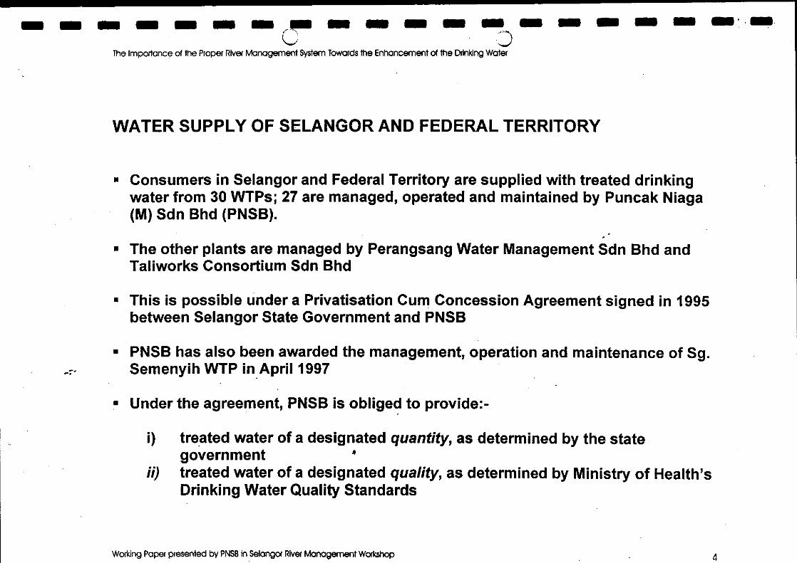
WATER SUPPLY OF SELANGOR AND FEDERAL TERRITORY
Consumers in Selangor and Federal Territory are supplied with treated drinkingwater from 30 WTPs; 27 are managed, operated and maintained by Puncak Niaga(M) Sdn Bhd (PNSB).
The other plants are managed by Perangsang Water Management Sdn Bhd andTaliworks Consortium Sdn Bhd
This is possible under a Privatisation Cum Concession Agreement signed in 1995between Selangor State Government and PNSB
PNSB has also been awarded the management, operation and maintenance of Sg.Semenyih WTP in April 1997
Under the agreement, PNSB is obliged to provide:-
treated water of a designated quantity, as determined by the stategovernmenttreated water of a designated quality, as determined by Ministry of Health'sDrinking Water Quality Standards
Working Paper presented by PNSB in Selangor River Management Workshop 4
WATER TREATMENTPLANT
Balancing Reservoir
3The Importance of the Proper River Management System Towards the Enhancement of the Drinking Water
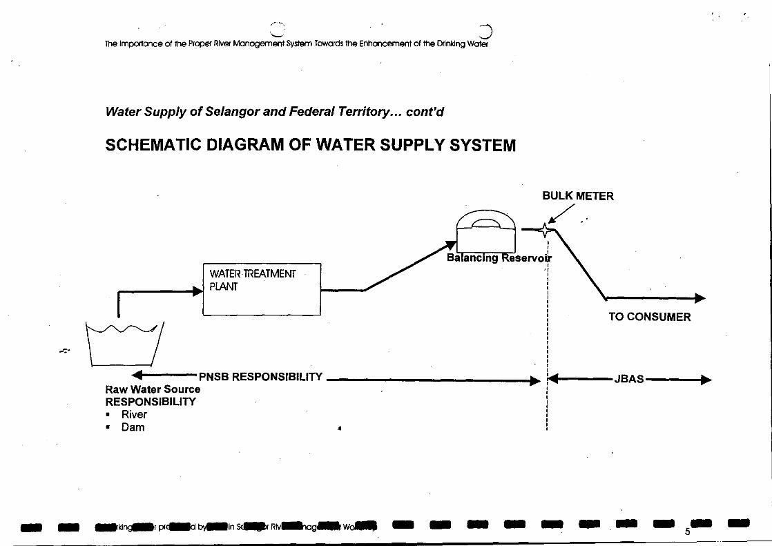
Water Supply of Selangor and Federal Territory... cont'd
SCHEMATIC DIAGRAM OF WATER SUPPLY SYSTEM
BULK METER
TO CONSUMER
11--JBAS --4PNSB RESPONSIBILITY Raw Water SourceRESPONSIBILITY
RiverDam 4
MN prellad bYMMIIn seller RivINSAIIMIt won". all 11111 1111111 111111 101111 I I I III 111111 111•11 51.•
• IS MSS Mil IS IS • OM 11111 MI MOM OM MI IIINC,1111111
The importance of the Proper River Management System Towards the Enhancement of the Drinking Water
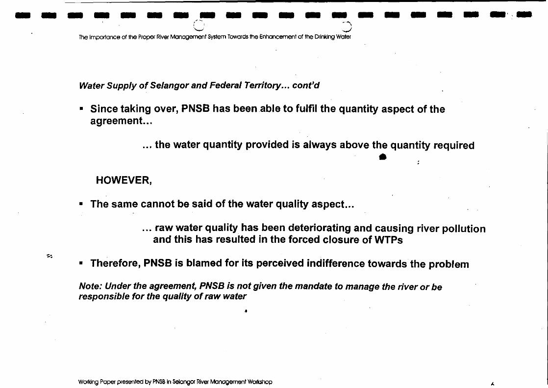
Water Supply of Selangor and Federal Territory... coned
Since taking over, PNSB has been able to fulfil the quantity aspect of theagreement...
... the water quantity provided is always above the quantity required
HOWEVER,
The same cannot be said of the water quality aspect...
... raw water quality has been deteriorating and causing river pollutionand this has resulted in the forced closure of WTPs
Therefore, PNSB is blamed for its perceived indifference towards the problem
Note: Under the agreement, PNSB is not given the mandate to manage the river or beresponsible for the quality of raw water
Working Paper presented by PNSB in Selangor River Management Workshop A
The Importance of the Proper River Management System Towards the Enhancement of the Drinking Water
Water Supply in Selangor and Federal Territory... cont'd
When the plant is temporarily closed down, consumers will be deprived ofwater supply and all the basic human activities come to a stop
The implications will also have far - reaching nationalistic repercussions
Businesses and investments from overseas will be critically affected; henceaffecting the nation's economic growth
DO WE WANT TO EXPERIENCE THIS SCENARIO?°M.
amkoridaser led giitB In isitor Ananarita m r
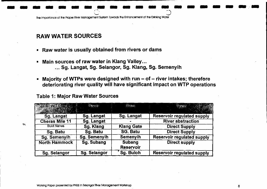
Sg. Langat Sg. Langat Sg. Langat Reservoir regulated supplyCheras Mile 11 Sg. Langat River abstraction
Bukit Nanas Sg. Kiang Kiang Gate Direct SupplySg. Batu Sg. Batu SG. Batu Direct Supply
Sg. Semenyih Sg. Semen ih Semenyih Reservoir regulated supplyNorth Hammock Sg. Subang Subang
ReservoirDirect supply
Sg. Selangor Sg. Selangor Sg. Buloh Reservoir regulated supply
fit-: toot
• OM MI WEI Mill — SIMI _11111111 MS • • • • • MO • • MO S SD
The Importance of the Proper River Management System Towards the Enhancement of the Drinking Water
RAW WATER SOURCES
Raw water is usually obtained from rivers or dams
Main sources of raw water in Kiang Valley...Sg. Langat, Sg. Selangor, Sg. Kiang, Sg. Semenyih
Majority of WTPs were designed with run — of — river intakes; thereforedeteriorating river quality will have significant impact on WTP operations
Table 1: Major Raw Water Sources
Working Paper presented by PNSB In Selangor River Management Workshop 8
0The Importance of the Proper River Management System Towards the Enhancement of the Drinking Water
Raw Water Sources... cont'd
Realising the importance of protecting our raw water source, PNSB, underIts own initiative, have set up an Environmental Unit
It is set up to undertake a comprehensive analysis of the raw water quality of allsix catchment areas that serve the WTPs
In addition to that, we can also identify the source(s) of contamination alongthe river banks; hence, we able to identify the on — going activities inthe catchment areas
Reports of the studies conducted have been submitted to the relevant Authorities,Along with recommendations to overcome the deteriorating raw water issue
II•1I 11111111kIngllar ballin Sena Rtvaltagall SIM 0 MO •II• • 9Ia •
MI MI IS a, 11111111 • IIIIIII MIN • OS'S=
The Importance of the Proper River Management System Towards the Enhancement of the Drinking Water
RAW WATER ANALYSIS
PNSB are obliged to provide water which meets the Ministry of Health'sDrinking Water Standards
Therefore, two(2) hourly analysis of basic pollutional parameters....•... during an alert, tests are carried out hourly... in case of a plant shutdown, tests are carried out every 30 minutes
Furthermore, weekly analysis of micro — biological parameters is also conducted
Employ independent certified laboratory to analyse the raw and treatedwater samples monthly
There are 54 water quality parameters to be analysed, each with its own testingschedule
Results of the monthly analysis are submitted to the Authorities for further action
Working Paper presented by PNSB in Selangor River Management Workshop 10
The Importance of the Proper River Management System Towards the Enhancement of the Drinking Water
Raw Water Analysis... cont'd
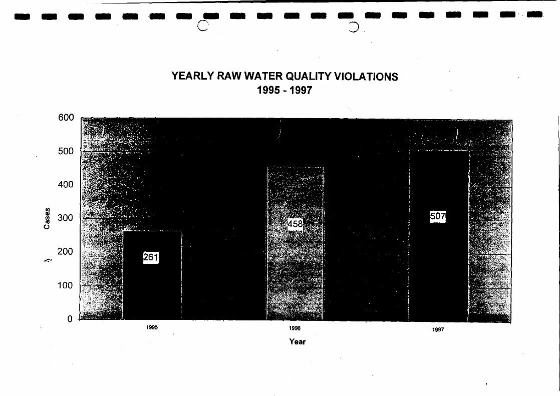
Results:
Results of the monthly raw water analysis clearly indicates that raw waterviolations are on the upswing
IN 1997, THERE HAVE BEEN A 90% INCREASE OF RAW WATER QUALITYVIOLATIONS AS COMPARED TO THE WHOLE OF 1995
(chart 1)
This is an alarming development and causing grave concern to relevant parties
The situation has the potential to deteriorate further if no action is taken...
... more rivers will be beyond conventional treatment... rivers will lose their basic function as a source of drinking water... consumers will lose their basic rights for life sustainability... marine life will be deprived in their natural habitat
am gm elLglift prat by In see lama Wo en an' an mil' 1 Ian
a a IS UM SS OM a OM M OM a a a a a a a IS MI IS3
YEARLY RAW WATER QUALITY VIOLATIONS1995 - 1997
600
500
400
91 300
200
100
1995
1996
1997
Year
The Importance of the Proper River Management System Towards The Enhancement of the Drinking Water
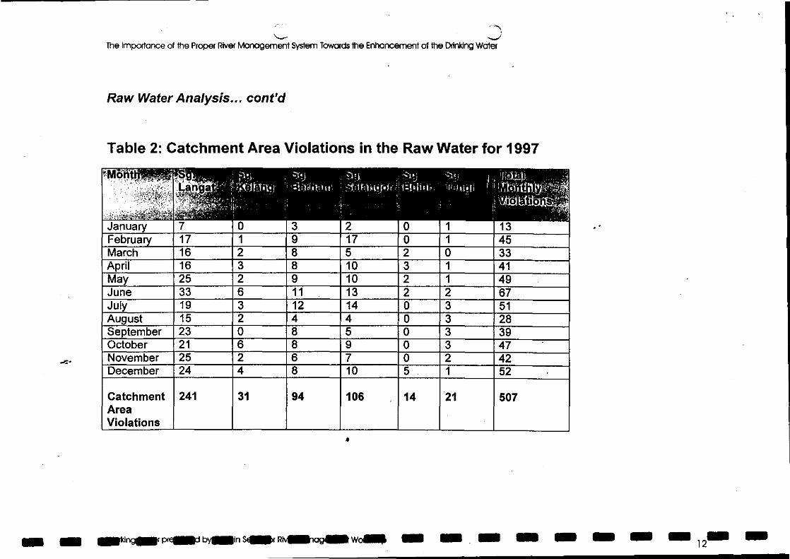
Raw Water Analysis... cont'd
Table 2: Catchment Area Violations in the Raw Water for 1997-.
January
-
7
t )fr k irt it. i
0
..:t 1 1
3
-:41. 1 i q. For
2
' : 1°I ioir i
0
4
' 1 041 ' ;IitgilitthltMEW.
1 13February 17 1 9 17 0 1 45March 16 2 8 5 2 0 33April 16 3 8 10 3 1 41May 25 2 9 10 2 1 49June 33 6 11 13 2 2 67July 19 3 12 14 0 3 51August 15 2 4 4 0 3 28September 23 0 8 5 0 3 39October 21 6 8 9 0 3 47November 25 2 6 7 0 2 42December 24 4 8 10 5 1 52
CatchmentAreaViolations
241 31 94 106 14 21 507
er nger pry byswin siler sea was ow se • um a 12".
On 111111 a a a an a a a a a 11.111(.111M.
DThe Importance of the Proper River Management System Towards the Enhancement of the Drinking Water
Raw Water Analysis... cont'd
From the table, it can be seen that:
Sg. Langat Catchment Area has the highest incidence of raw water violations with47.5% in 1997
It is followed by Sg. Selangor with 20.9% and Sg. Bernam with 18.5%, of total rawwater violations
Working Paper presented by PNSB In Selangor River Management Workshop 13
The Importance of the Proper River Management System Towards the Enhancement of the Drinking Water
Raw Water Analysis... cont'd
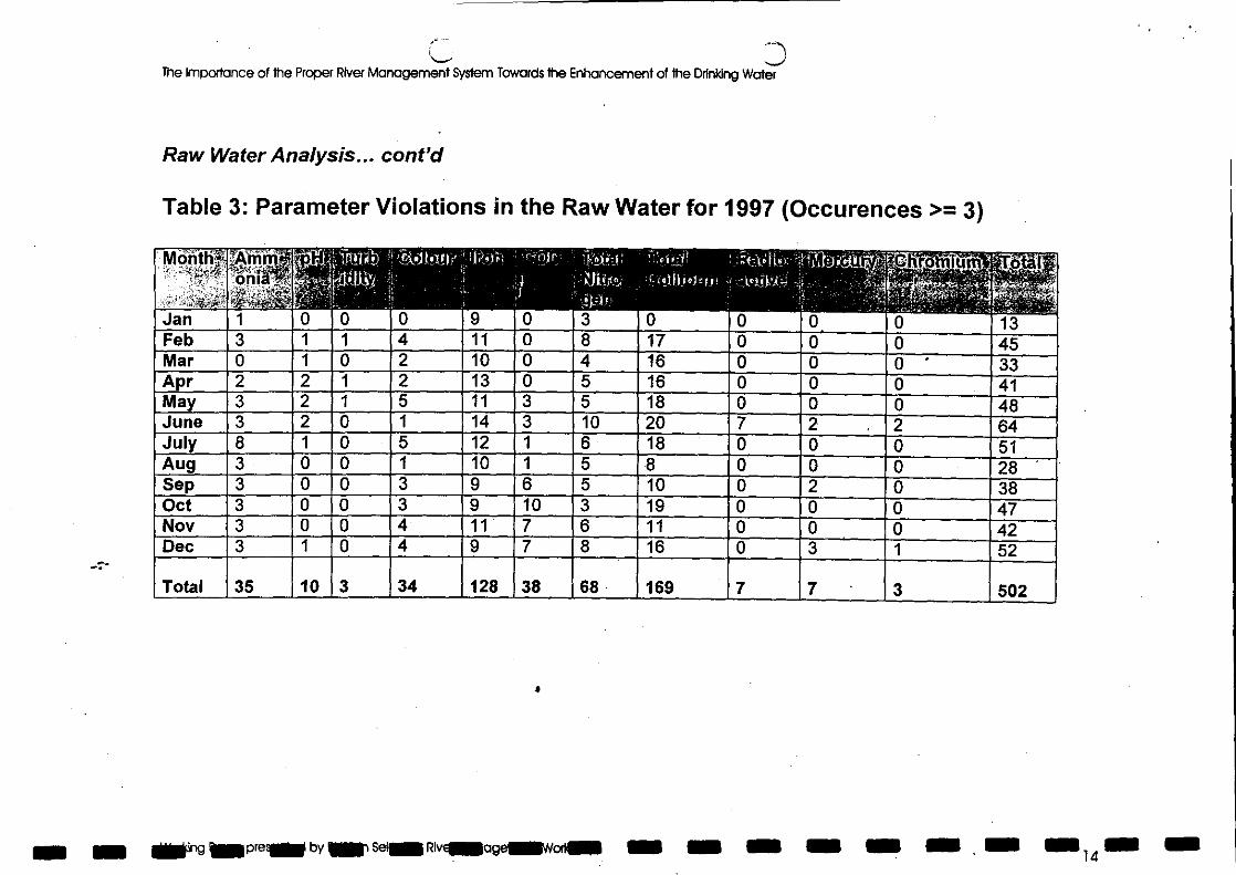
Table 3: Parameter Violations in the Raw Water for 1997 (Occurences >= 3)
le/lbehir
Jan 1 0 0 0 9 0 3 0 0 0Feb 3 1 1 4 11 0 8 17 0 0Mar 0 1 0 2 10 0 4 16 0 0Apr 2 2 1 2 13 0 5 16 0 0May 3 2 1 5 11 3 5 18 0 0June 3 2 0 1 14 3 1 0 20 7 2
8 1 0 5 12 1 6 18 0 0AugSep
3 0 0 1 10 1 5 8 0 03 0 0 3 9 6 5 10 0 2
Oct 3 0 0 3 9 10 3 19 0 0Nov 3 0 0 4 11 7 6 11 0 0Dec 3 1 0 4 9 7 8 16 0 3
Total 35 1 0 3 34 128 38 68 169 7 7
a
111111bretall by 1111. Sean Ply€111.09einWoriali On a la
0 130 450 330 410 482 640 510 280 380 470 421 52
3 502
S MEM a 14
IMO I= MO MN rEINIMINMINIM101•1=INOMMNIIM
The Importance of The Proper River Management System Towards the Enhancement of the Drinking Water
Raw Water Analysis... cont'd
Table 3 has shown that:
Total Coliform parameter occurred most frequently with 33.7% in 1997
This is followed by Iron with 25.5% and Total Nitrogen with 13.5% of totalparameter violations in raw water
The data shows that most of the raw water sources for Selangor and FederalTerritory consist of organic matters
Total Coliform Count estimated the number of bacteria of the "Coliaerogenes"group, of both faecal and non — faecal origin...
... hence Total Coliform Count denotes the likelihood of sewagepollution
a
Working Paper presented by PNSB In Selangor River Management Workshop 15
The Importance of the Proper River Management System Towards the Enhancement of the Drinking Water
Raw Water Analysis... cont'd
PNSB Environmental Unit's studies have identified the following activities conductedwithin the catchment areas that contribute towards raw water pollution:
Effluents from factories and farmsLand clearing and forest clearing activitesMining activitiesDisposal of garbageWaste water discharges
These activities have resulted in the deteriorating river condition which has forcedthe temporary closure or unscheduled shutdown of the water treatment plants
a
11= wing pre.. by NW seal Rtvd11111116galliwoin. • IS IS MN IS • IS IS16
a MN OS In a a, a NM SI M UM MSa a s a OM a,
The Importance of the Proper River Management System Towards the Enhancement of the Drinking Wafer
Raw Water Analysis... cont'd
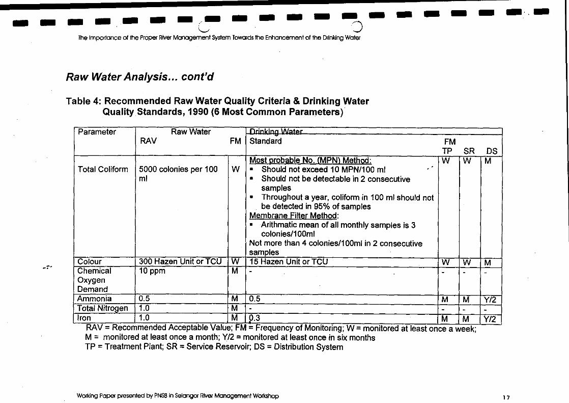
Table 4: Recommended Raw Water Quality Criteria & Drinking WaterQuality . Standards, 1990 (6 Most Common Parameters)
Parameter Raw WaterRAV FM
_Drinking WaterStandard FM
TP SR DS
Total Coliform 5000 colonies per 100ml
WMost probable No. (MPN) Method: W W Mn Should not exceed 10 MPN/100 mln Should not be detectable in 2 consecutive
samplesn Throughout a year, coliform in 100 ml should not
be detected in 95% of samplesMembrane Filter Method:n Arithmatic mean of all monthly samples is 3
colonies/100m1Not more than 4 colonies/100m1 in 2 consecutivesamples
Colour 300 Hazen Unit or TCU W 15 Hazen Unit or TCU W W MChemicalOxygenDemand
10 ppm M - - - -
Ammonia 0.5 M 0.5 M M Y/2Total Nitrogen 1.0 M - - - -Iron 1.0 M 0.3 M M Y/2
= Recommended Acceptable Value; FM = Frequency of Monitoring; W = monitored at least once a week;M = monitored at least once a month; Y/2 = monitored at least once in six monthsTP = Treatment Plant; SR = Service Reservoir; DS = Distribution System
Working Paper presented by PNSB In Selangor River Management Workshop 1 7
The Importance of the Proper River Management System Towards the Enhancement of the Drinking Water
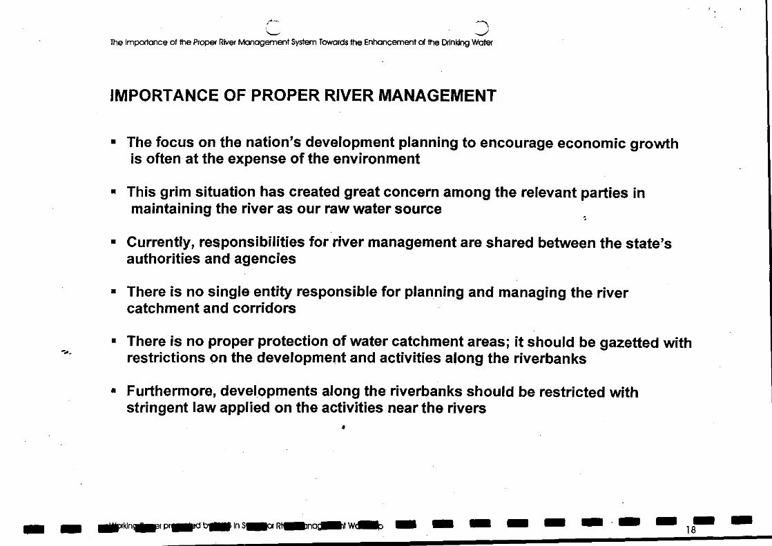
IMPORTANCE OF PROPER RIVER MANAGEMENT
The focus on the nation's development planning to encourage economic growthis often at the expense of the environment
This grim situation has created great concern among the relevant parties inmaintaining the river as our raw water source
Currently, responsibilities for river management are shared between the state'sauthorities and agencies
There is no single entity responsible for planning and managing the rivercatchment and corridors
There is no proper protection of water catchment areas; it should be gazetted withrestrictions on the development and activities along the riverbanks
Furthermore, developments along the riverbanks should be restricted withstringent law applied on the activities near the rivers
• • MP"INF ball Sailor RencliMt Wca MI NM MIN MI AM18
.C.
as a a st senal I= au sm..=
The Importance of the Proper River Management System Towards the Enhancement of the Drinking Water
Importance of Proper River Management.. cont'd
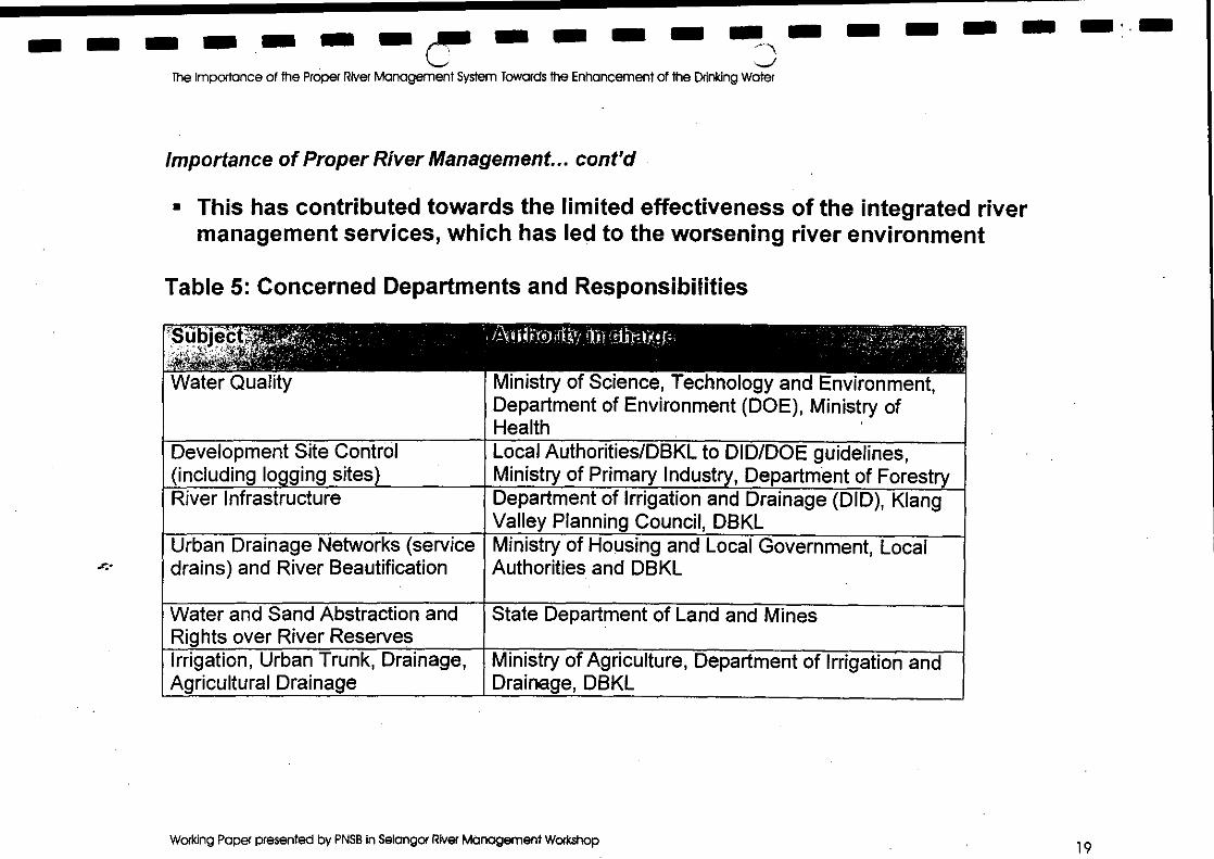
n This has contributed towards the limited effectiveness of the integrated rivermanagement services, which has led to the worsening river environment
Table 5: Concerned Departments and Responsibilities
'' d jec '
Water Quality
/Au i/ k-roffili lit letit:EMP
Ministry of Science, Technology and Environment,Department of Environment (DOE), Ministry ofHealth
Development Site Control(including lo•ging sites)
Local Authorities/DBKL to DID/DOE guidelines,Ministry of Primary Industry, Department of Forest
River Infrastructure Department of Irrigation and Drainage (DID), KiangValley Planning Council, DBKL
Urban Drainage Networks (servicedrains) and River Beautification
Ministry of Housing and Local Government, LocalAuthorities and DBKL
Water and Sand Abstraction andRights over River Reserves
State Department of Land and Mines
Irrigation, Urban Trunk, Drainage,Agricultural Drainage
Ministry of Agriculture, Department of Irrigation andDrainage, DBKL
Working Paper presented by PNSB in Selangor River Management Workshop 19
The Importance of the Proper River Managemen
•
t ystt, r Towards the Enhancement of the Drinking Water
Importance of Proper River Management.. cont'd
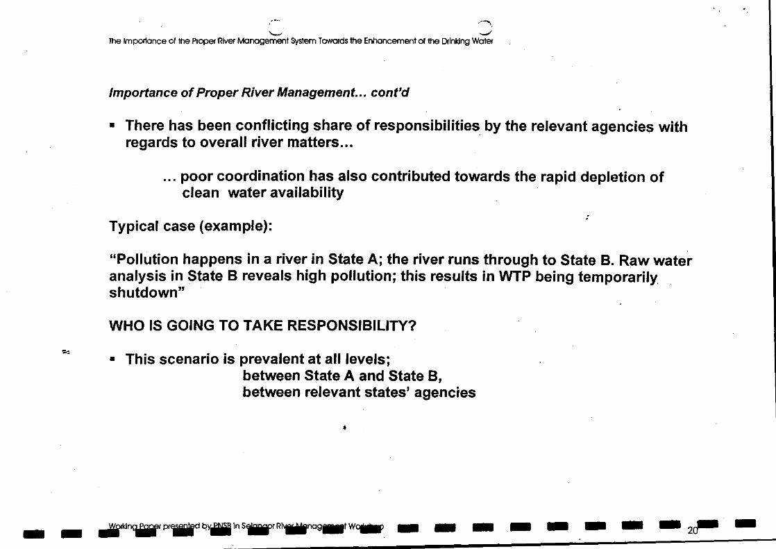
There has been conflicting share of responsibilities by the relevant agencies withregards to overall river matters...
... poor coordination has also contributed towards the rapid depletion ofclean water availability
Typical case (example):
"Pollution happens in a river in State A; the river runs through to State B. Raw wateranalysis in State B reveals high pollution; this results in WTP being temporarily,shutdown"
WHO IS GOING TO TAKE RESPONSIBILITY?t-,
n This scenario is prevalent at all levels;between State A and State B,between relevant states' agencies
_ _ jddn pr by j insilirillinager *inns am a s ass tie
IS IS S S NM )111 • SS • 0 IS a MI MI a.
The Importance of the Proper River Management System Towards the Enhancement of the Drinking Water
Importance of Proper River Management... cont'd
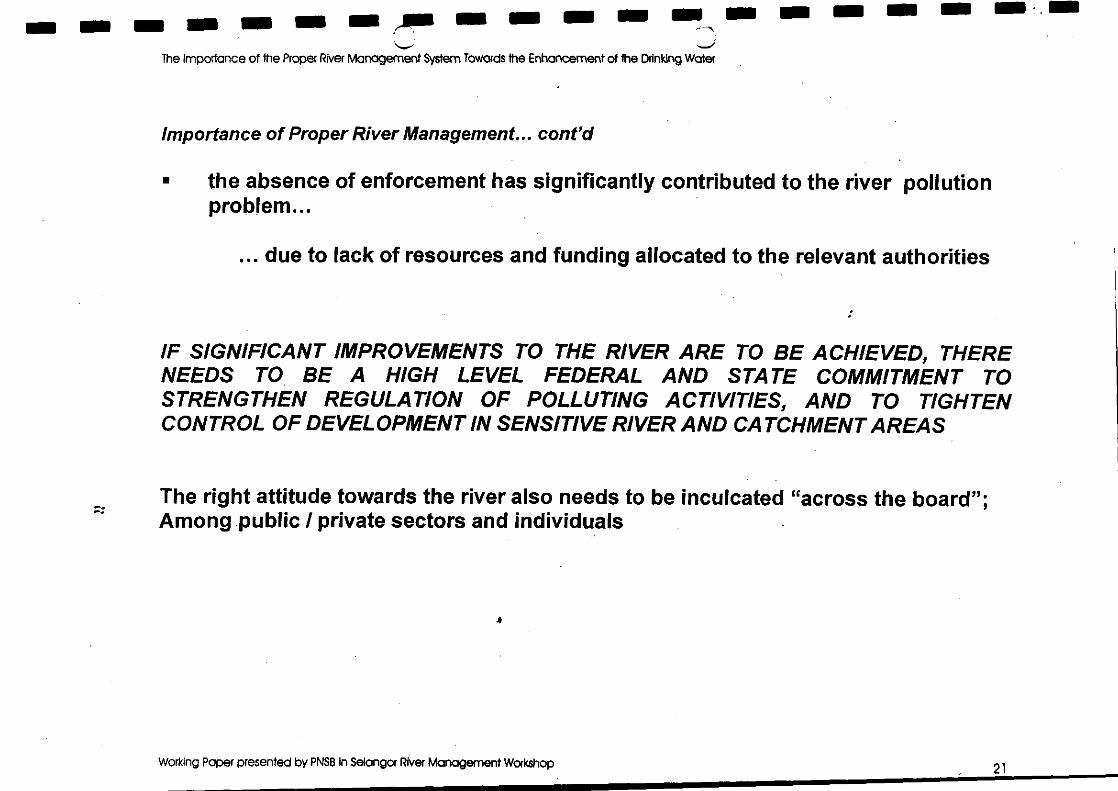
n the absence of enforcement has significantly contributed to the river pollutionproblem...
... due to lack of resources and funding allocated to the relevant authorities
IF SIGNIFICANT IMPROVEMENTS TO THE RIVER ARE TO BE ACHIEVED, THERENEEDS TO BE A HIGH LEVEL FEDERAL AND STATE COMMITMENT TOSTRENGTHEN REGULATION OF POLLUTING ACTIVITIES, AND TO TIGHTENCONTROL OF DEVELOPMENT IN SENSITIVE RIVER AND CATCHMENT AREAS
The right attitude towards the river also needs to be inculcated "across the board";Among public / private sectors and individuals
Working Paper presented by PNSB in Selangor River Management Workshop 21
.01•••
The Importance of the Proper River Management System Towards the Enhancement of the Drinking Water
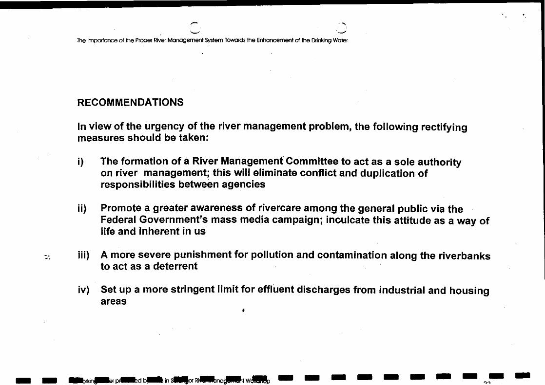
RECOMMENDATIONS
In view of the urgency of the river management problem, the following rectifyingmeasures should be taken:
The formation of a River Management Committee to act as a sole authorityon river management; this will eliminate conflict and duplication ofresponsibilities between agencies
Promote a greater awareness of rivercare among the general public via theFederal Government's mass media campaign; inculcate this attitude as a way oflife and inherent in us
A more severe punishment for pollution and contamination along the riverbanksto act as a deterrent
Set up a more stringent limit for effluent discharges from industrial and housingareas
11/1 alarkinSer prIlMd billa in Mk RINIandjilikt Wp 1.1. Mil MI
11110 1.1111 INIME.Pli MI In 1111.1 Me MVO.
The Importance of the Proper River Management System Towards the Enhancement of the Drinking Water
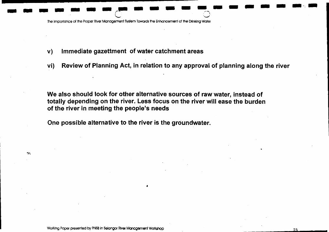
Immediate gazettment of water catchment areas
Review of Planning Act, in relation to any approval of planning along the river
We also should look for other alternative sources of raw water, instead oftotally depending on the river. Less focus on the river will ease the burdenof the river in meeting the people's needs
One possible alternative to the river is the groundwater.
Working Paper presented by PNSB In Selangor River Management Workshop
The Importance of the Proper Wei Management System Towards the Enhancement of the Drinking Water
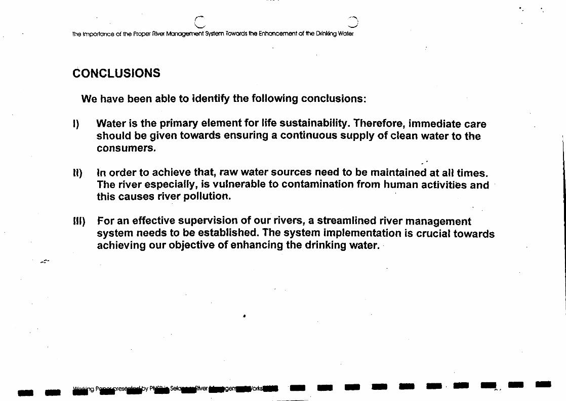
CONCLUSIONS
We have been able to identify the following conclusions:
Water is the primary element for life sustainability. Therefore, immediate careshould be given towards ensuring a continuous supply of clean water to theconsumers.
In order to achieve that, raw water sources need to be maintained at all times.The river especially, is vulnerable to contamination from human activities andthis causes river pollution.
III) For an effective supervision of our rivers, a streamlined river managementsystem needs to be established. The system implementation is crucial towardsachieving our objective of enhancing the drinking water.
-r-
Ns PSI waiver Segentakodn EnS 5 11. NO
BENGKEL PENGURUSAN SUNGAI NEGERI SELANGOR
29-31 Mac 1998De Palma Inn Kuala Selangor
RIVERFRONT DEVELOPMENT- A GUIDELINE FOR SUSTAINABLE DEVELOPMENT
byDr. Halimaton Saadiah bte. Hashim
Pengarah Perancangan Bandar dan Desa Negeri Selangor.
1.0 INTRODUCTION
Mention the phrase 'riverfront development', and one immediately conjures the image of
the 'romantic Seine' in Paris, the 'dancing Blue Danube' in Vienna, the 'rich commercial
fronts' of the Thames in London or the scenic banks of Swan River in Perth. The waters
of these rivers are clean and clear that it is not surprising that many look towards these
places for examples of riverfront development. In Selangor, there are exciting proposals
for the 'Malaysian Blue Danube along Sungai Langat-Sungai Semenyih, the Water City'
of Batang Berjuntai and the Riverine Development Proposal along Sungai Selangor.
Pertinent questions are seldom asked, such as 'can the above landscapes alone
produce clear blue waters? What are the mechanisms that go beyond the riverfront
developments? Can the same mechanisms be applied here in Selangor and for
Selangor rivers?' One seldom asks 'what are the appropriate developments for the
banks of our rivers here in Malaysia? This is a pertinent question as we have different
climates, different ecosystems, different ecology, different hydrology and the like. As
such can we have the same type of developments alongside our rivers as for those
exotic places?
The Selangor Town and Country Planning Department has not yet prepared a set of
comprehensive guidelines for riverfront development. The preparation of this set of
guidelines is beyond the work of this department alone, for what land uses lie beyond
the river banks, i.e. in the river catchment area determine, in one way or the other, the
form of riverfront development that can be proposed along both banks of the rivers.
Addressing the complexity of the river system and its environs needs concerted efforts of
many parties, from tehcnical experts, administrators, and policy as well as decision
makers.
Following the above, it follows therefore that first and foremost, there is a need to
determine the land uses within a river catchment area. Ideally the determination of
theses land uses will be determined by a set of guidelines which conform, directly and
indirectly to the principles and concept of sustainable development. Nevertheless, in
view of many uncertainties, adopting the 'precautionary approach' to sustainable
development, the department has imposed a 'blanket' set of guidelines for planners and
developers, including mainly:
Imposition of a buffer stretch of between 66 feet to 132 feet alongside rivers;
No development is to 'back' the rivers; and
3. No new industrial land is to be by the river banks, except for some special
industries whose operations depend on the rivers.
The appropriate task to do is to prepare a set of planning guidelines which are based on
principles and concepts of sustainable development These planning guidelines will then
be modified to suit different habitats and ecosystem. The function of the rivers
concerned too has a bearing on the types of development that can be allowed along its
banks.
Following the above arguments, this paper first discusses the concept and principles of
sustainable development and its operational perspectives. Then it discusses a general
guideline for sustainable development which will form the framework for the formulation
of planning standards or indicators for riverfront development.
2.0 THE CONCEPT OF SUSTAINABLE DEVELOPMENT
There are currently over a hundred definitions of sustainable development. However for
the purpose of this paper, only one definition is referred to, i.e. the definition by the
World Commission on Environment and Development (WCED) in 'Our Common Future'
(1987) which has been generally accepted and adopted world-wide. The definition is as
follows:
2
°Sustainable development is development that meets the needs of the presentwithout compromising the ability of future generations to meet their own needs. Itcontains within it two key concepts:
The concept of 'needs' in particular the essential needs of the wold's poor, towhich overriding priority should be given; andThe idea of 'limitations' imposed by the state of technology and socialorganization on the environment's ability to meet present and future needs.
...In essence, sustainable development is a process of change in which theexploitation of resources, the direction of investment, the orientation of technologicaldevelopment, and institutional change are all in harmony and enhance both currentand future potential to meet human need and aspirations."(WCED, 1987. Pp. 43-44).
The above definition does not explain how sustainable development is to be achieved
and this has resulted in many discussions as to its interpretation. This is probably one of
the reasons for the slowness in taking actions towards realizing sustainable
development. Therefore a country or a planning or development authority has to adopt
an operational perspective so as to guide its actions towards a common path.
Functional perspective of sustainable development
There are several functional perspectives to sustainable development. However only two
are noted here, due to the relative clarity of these perspectives. English Nature (1992)
has identified sustainable development into two versions:
'Trade-off version which requires that environmental considerations aretaken into account in policy formulation, but allowing such considerations tobe traded off against other goods to generate the socially optimal or desirable
results. This is synonymous with the 'weak sustainability' terminology; and
`Sustainability limits' version where environmental conditions act asconstraints or limits on the achievement of other socio-economic goals, which
is synonymous with 'strong sustainability'.
The 'trade-off' version requires evaluation of environmental costs and benefits and their
incorporation into cost-benefit analysis, which is within the reign of environmental
economics. This is particularly significant when there is a need to reconcile between
3
competing economic, social and environmental requirement, such as in decision-making
by the government. The critical issue in this version is how to assign true costs and
benefits to natural environmental resources which am dependent on value judgements
as to their worth, and what aspect of the environment am tradeable. This involves a
balanced accommodation of values and interests in the context within which it is
undertaken, including meeting all goals at some minimum thresholds, while ensuring that
no goal should be consistently promoted or discounted at the expense of the others.
The 'sustainability limits' version requires that, irrespective of any development, respect
Q must be given to the tanying capacity' of the environment. This is regarded as the
maximum impact that the earth or any ecosystem can sustain (IUCN, UNEP, WWF
1992). It implies the existence of limits to development and economic activity. Planning
and development within the limits of carrying capacity means that humankind is
dependent on the productive capacity of ecosystems, and that some minimal level of
ecosystem integrity is essential to human survival.
For most animal species, carrying capacity is defined as the maximum population that
can be supported indefinitely in a given habitat without permanently impairing the
productivity of the ecosystem(s) upon which it is dependent.
For humankind, carrying capacity can be defined as the maximum rate of resource
consumption and waste discharge that can be sustained indefinitely in a defined impact
region without progressively impairing bioproductivity and ecological integrity. A crucial
element of carrying capacity is that it is ultimately determined by the single vital resource
or function in least supply (Rees 1998).
Carrying capacity is a function of many variables including:
the region in question, e.g. a watershed, the world
the type of resource in question, eg. Water, energy, whatever resource would
limit the growth of the human population
what is being 'carried' e.g. human population, noxious gas emissions
whether the resource is assumed to be constant or is changing over time, and
whether it is renewable or not
whether what is being 'carried' is assumed to be constant or not
4
• value judgements, e.g. ideal/optimum capacity versus maximum/minimum
capacity
...in order to ensure sustainability, carrying capacities should not be exceeded.
(Therivel eta!. 1992. Pp.124-125).
To ensure that canying capacity is not exceeded, the current state of the resource and
its uses must be monitored; predictions must be made concening the future state of the
resource and its uses and the possible use of alternatives; and mitigation measures
must be made available to be implemented if the uses exceed, or threaten to exceed,
the carrying capacity. These are problematic because it requires an understanding of
how much of the resource is available, information which is difficult if not impossible to
derive. In addition it is a dynamic situation, where technological innovations may affect
carrying capacity.
Determining the land uses and development which are within carrying capacities is
difficult because the mechanisms of natural capital is still largely unknown, and scientific
discoveries and technological advances are relatively slower than the need for
development. Therefore where lack of information is a critical deterrent to making
decisions on the basis of evidence i.e. when potential damage to the environment is both
uncertain and significant, it is necessary to act on the basis of the 'precautionary
principM'. This principle is consistent with Principle 15 of the Rio Declaration on
Environment and Development (UNCED 1992): "Where there are threats of serious or
irreversible damage, lack of full scientific certainty shall not be used as a reason for
postponing cost-effective measures to prevent environmental degradations.
Accommodating the principle that 'prevention is better than cure', conserving natural
capital is especially important to sustainable development.
Another problem is that the types and uses of various resources are not known.
Technological innovations can have major impacts (both positive and negative) on
carrying capacity which in turn relies on inherent value judgements and the use of
biological standards against which the severity of an impact can be measured. The
greatest uncertainty is the level of pressure that natural resources can withstand before
they collapse (Therivel et. al. 1992).
5
3.0 THE ROLE OF LAND USE PLANNING IN SUSTAINABLE DEVELOPMENT
Until the last ten years or so, there has been little recognition of the positive role thatland use planning can play in securing and facilitating a good environment in Malaysia.
This is in contrast from foreign countries such as England and the Netherlands, whereland use planning plays the pivotal role in determining developments.
The Rio Earth Summit proclaims twenty-seven principles which would facilitate thetransition to sustainability, and Agenda 21 proposes a broad-based programme of actioncovering developmental and environmental issues in an integrated approach. Table 1shows some of the strong 'messages from Rio'. In summary, the messages say that land
use planning must be 'environment-led' and include environmental resourcemanagement. There must be integration of environment and development in decision-
making, and there must be sustainable human settlements planning which integratecitizen-participation in its planning and decision-making process, backed by strong,comprehensive planning laws which reflect modem understandings of natural resources
Making choices on the use of resources involves a well-informed decision-makingprocess. It needs a 'policing' mechanism to assess whether or not policies, plans andprogrammes could be termed as contributing towards sustainable development or'unsustainable development' instead. In addition, it requires monitoring of sustainabilityby evaluating impacts of development on natural resources, particularly on the carrying
0 capacity of the ecosystem. The integration of impact assessment in land use planning isa proactive approach in which the requirement for sustainability is the drivingconsideration and the permissible level of economic activity is the dependent variable.
6
111
11
1
1111
1
1
1
1
11
Environmental issues are best handled with theparticipation of all concerned citizens at therelevant level (Principle 10)
States shall enact effective environmentallegislation (Principle 11)
The precautionary approach shall be widelyapplied by States (Principle 15) andenvironmental impact assessment shall beundertaken for appropriate developments(Principle 17)
CHAPTERS FROM AGENDA 21Need to change patterns of consumption,review the purchasing policies of agencies anddepartments, and sustainable use of renewableresources (Chapter 4)
Need to adopt innovative planning strategies,and guide cities along sustainable paths,involving citizen participation, resourceinventories and evergy and transport systems(Chapter 7)
There is a need for environmental auditing,environmental assessment at all level,integrated data management and sustainableurban and rural spatial (Chapters 8 & 9)
By 1996, most local authorities should haveaccomplished, on a collaborative basis, a localAgenda 21" for the community (Chapters 27-31)
There should be higher status for citizengroups, of which women forms a big group, inenvironmental decision-making (Chapter 24 &36) Developed after Selman 1993.
Major implications for public participation,information provision, communityempowerment and subsidiarity in planning.
Need for strong, comprehensive planning lawswhich, as part of a wider body of environmentallaw, reflect modern understandings of naturalprocesses.
Environmental statements should be used as aprincipal means of minimising damage anduncertainty.
Land use planning should includeenvironmental resource management.
There should be sustainable humansettlements planning which integrate citizenparticipation in its planning and decision-making process.
There should be integration of environment anddevelopment in decision-making and integratedplanning and management of resources.
Institutions, particularly local authorities, andnon-governmental organisations must playeffective and efficient roles in environmentalplanning.
Education, increased public awareness andtraining in citizen participation in environmentalplanning must be enforced effectively.
Table 1: WORLD'S RESOLUTION ON LAND USE PLANNING — MESSAGES FROMTHE RIO WORLD EARTH SUMMIT 1992
PRINCIPLES MESSAGES PRINCIPLES FROM RIO DECLARATIONDevelopment and environmental needs of Planning must address the meaning andpresent and future generations need to be met practical consequences of 'sustainableequitably (Principle 3) development'.
Environmental protection shall constitute an Development plans should be 'environment-integral part of the development process and led'cannot be considered in isolation from it(Principle 4)
7
4.0 DETERMINING LAND USES WITHIN THE SUSTAINABLE DEVELOPMENTCONCEPT
Determining land uses which comply with the sustainable development approach is
complex because it involves the balancing of resources until the right equilibrium is
achieved. The loss of the natural capital (resources) must be balanced with the gain in
the man-made capital (resources). .One is always faced with the decision of choosing
between economic development and environmental protection. However this should not
be an issue because the concept of secologinomics' which is the combination of
ecological and economic analysis (Carpenter and Dixon 1985) will improve the quality of
advice to policy and decision makers.
Four crucial factors assist in determining land uses which contribute towards sustainable
development:
The concept of catchment area or ecosystem i.e. a balance of man-made and
natural resources;
The need for integrated planning and management of resources;
The need for efficient planning of the major landuses of agriculture and forestry;
and
The planning and management of critical resources such as water and minerals,
as well as the planning and management of recreational areas and localities of
scientific, scenic and historic interest.
The four factors are briefly explained below:
Planning within ecosystemsEcosystems cover the interaction between people and other forms of life and the
environment in which they live. The concern is for the integration of activities and land
use, as well as the conservation of biological diversity. The two major stances are:
Nature of the natural processes of the physical world, including people, must be
kept in balance or human activities will end up destroying the biosphere in which
we live; and
8
Biotechnology will enable us to survive even though the balance is greatly altered
to meet new demands, depending on what new developments emerge in our
efforts to provide a sustainable development.
In relation to river management, the planning area and planning decisions must be within
the context of the river catchment area.
The integrated planning and management of natural resources
The objective of environmental management is to maintain the environment's carrying
capacity on behalf of sustainable development. There is a need to resolve conflicts
between environmental aims and other policy objectives. One approach is towards a
systematic thinking to our environment: by considering man-made and natural systems
as one interacting ecosystem i.e. requires managing and planning in ways which
integrate the natural environment and man-made environment.
The efficient planning of agricultural and forestry land resource
Left to a free market, agricultural land is already going to other uses. Therefore there is a
Gear requirement to look very hard at the method for assessing land use in the fight of
future needs. Obviously the best soils should be conserved but there should be a harder
look at practices that use an excess of fertilizers and pesticides. Some basic
recommendations include:
Agricultural land of high productivity should continue to be protected through the
application of codes of good practice and with more attention to minimise the use
of fertilizers and pesticides;
Less valuable land should be assessed for its most beneficial use, leading to
guidelines for woodland and wildlife reserves, as well as for housing and
economic development;
Proposals for future use should be included in strategic plans together with their
justification; and
Forestry is an attractive investment for the future and therefore forest plantations
should be encouraged.
I 9
Other crucial natural resources
Water being a very crucial resource, there is a need for more attention to be paid towater supply and sewage disposal in an integrated approach within strategic plans forregions (catchment areas) as a determining factor in planning. Water must be
considered as a resource to be managed in association with all development. Plansshould be more positive about the consequences on the demand for water of the futureland use. As for special areas such as those with scientific interests, and withsignificance in wildlife, historic and scenic importance require integrated planning and arecognition of the dynamics of change. Integrated land use and design strategies should
be a key part of our system of environmental planning. One should be more careful of
0 recreational activities, because this activity often exploits natural heritage and oftenspoils what it values the most Therefore analyses of the potential of various resourcesfor growth should be made.
The important question that needs answering is 'what kind of ecosystem should beformed to meet the needs of sustainable development?'. A good general guide is:
The realization that land is a major resource which can be used economically,socially and environmentally for the fullest needs of the population; and
The need to plan and greatly raise the quality of design for the environment if we
are to survive i.e. design of sustainable ecosystems.
But how do we achieve the above? Below are some general planning guidelines which
0 have taken into consideration the concept and principles of sustainable development
and integrated them into land use planning principles.
5.0 LAND USE PLANNING CRITERIA FOR SUSTAINABLE DEVELOPMENT
Broad planning guidelines for sustainable development are proposed in the form of 125
land use planning criteria which are to guide planners, developers and decision-makersin both and short term planning and management.
It is noted that these criteria have not been tested scientifically. The land use planningcriteria for sustainable development have been identified form the analyses of planninglegislation, manuals, guidelines and other literature on developments in land use
to
planning for sustainable development, and environmental consideration and appraisal of
development plans. From Malaysia, particular reference is made to Act 172, The Town
and Country Planning Act 1976, Development Plans (Structure Plan and Local Plan)
Rules 1985, and a paper by TCPD (1987) titled Data Collection for Structure Plans:
Problems and Recommendations. Many land use planning documents have been
analysed. Of particular importance are Policy Appraisal and the Environment (Doe.UK
1991), PPG 12 (Doe.UK 1992) and Development Plans: A Good Planning Guide
(Doe.UK. 1992).
The aim and goals of sustainable development are listed in Table 2, the principles of
sustainable society are in Table 3, the strategic imperatives of sustainable development
are in Table 4, and the land use planning criteria for sustainable development are in
Table 5.
II
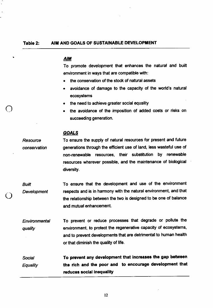
Table 2: AIM AND GOALS OF SUSTAINABLE DEVELOPMENT
• AIM
To promote development that enhances the natural and builtenvironment in ways that are compatible with:
the conservation of the stock of natural assetsavoidance of damage to the capacity of the world's naturalecosystemsthe need to achieve greater social equalitythe avoidance of the imposition of added costs or risks onsucceeding generation.
GOALSResource To ensure the supply of natural resources for present and future
conservation generations through the efficient use of land, less wasteful use ofnon-renewable resources, their substitution by renewableresources wherever possible, and the maintenance of biologicaldiversity.
Built To ensure that the development and use of the environment
Development respects and is in harmony with the natural environment, and that0 the relationship between the two is designed to be one of balance
and mutual enhancement.
Environmental To prevent or reduce processes that degrade or pollute the
quality environment, to protect the regenerative capacity of ecosystems,and to prevent developments that are detrimental to human healthor that diminish the quality of life.
Social To prevent any development that increases the gap between
Equality the rich and the poor and to encourage development that
reduces social inequality
12
Table 2: ...Continuation.
Political To change values, attitudes and behaviour by encouraging
Participation increased participation in political decision making and in initiating
environmental improvements at all levels from the local
community upwards.
Summarised from Blowers 1993, pp.6-8.
13
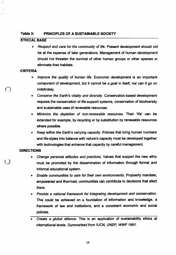
Table 3: PRINCIPLES OF A SUSTAINABLE SOCIETY
ETHICAL BASE
Respect and cam for the community of life Present development should not
be at the expense of later generations. Management of human development
should not threaten the survival of other human groups or other species or
eliminate their habitats.
CRITERIA
Improve the quality of human life. Economic development is an important
component of development, but it cannot be a goal in itself, nor can it go on
indefinitely.
Conserve the Earth's vitality and diversity. Conservation-based development
requires the conservation of life-support systems, conservation of biodiversity
and sustainable uses of renewable resources.
Minimize the depletion of non-renewable resources. Their 'life' can be
extended for example, by recycling or by substitution by renewable resources
where possible.
Keep within the Earth's carrying capacity. Policies that bring human numbers
and life-styles into balance with nature's capacity must be developed together
with technologies that enhance that capacity by careful management.
DIRECTIONS
Change personal attitudes and practices. Values that support the new ethic
must be promoted by the dissemination of information through formal and
informal educational system.
Enable communities to care for their own environments. Propoerly mandate,
empowered and ifnormed, communities can contribute to decisions that afect
them.
Provide a national framework for integrating development and conservation.
This could be achieved on a foundation of information and knowledge, a
framework of law and institutions, and a consistent economic and social
policies.
Create a global alliance. This is an application of sustainability ethics at
international levels. Summarised from IUCN, UNEP, WWF 1991.
14
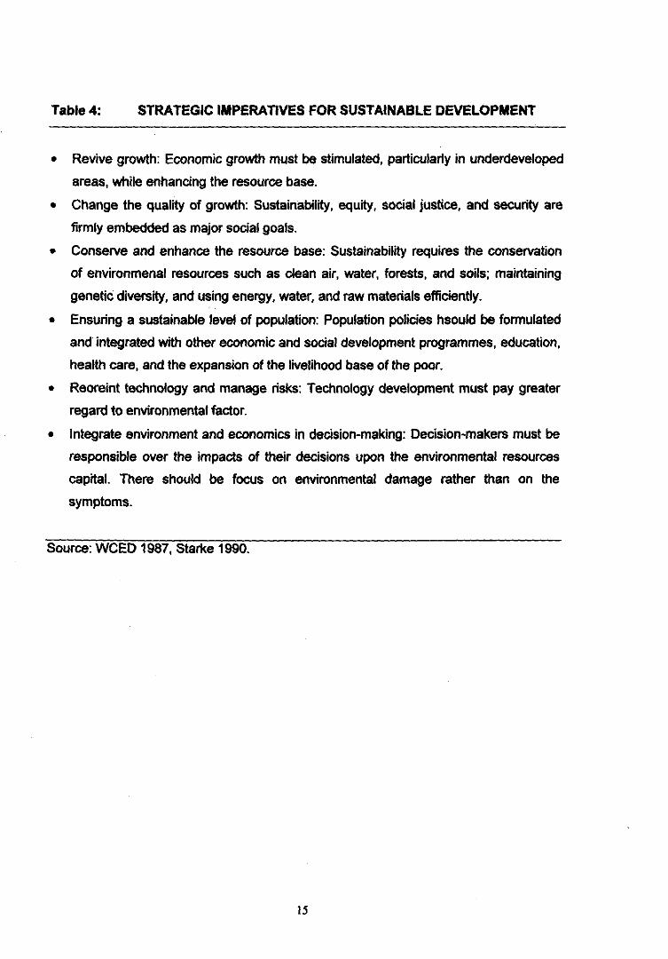
Table 4: STRATEGIC IMPERATIVES FOR SUSTAINABLE DEVELOPMENT
Revive growth: Economic growth must be stimulated, particularly in underdeveloped
areas, while enhancing the resource base.
Change the quality of growth: Sustainability, equity, social justice, and security are
firmly embedded as major social goals.
Conserve and enhance the resource base: Sustainability requires the conservation
of environmenal resources such as dean air, water, forests, and soils; maintaining
genetic diversity, and using energy, water, and raw materials efficiently.
Ensuring a sustainable level of population: Population policies hsould be formulated
and integrated with other economic and social development programmes, education,
health care, and the expansion of the livelihood base of the poor.
Reoreint technology and manage risks: Technology development must pay greater
regard to environmental factor.
Integrate environment and economics in decision-making: Decision-makers must be
responsible over the impacts of their decisions upon the environmental resources
capital. There should be focus on environmental damage rather than on the
symptoms.
Source: WCED 1987, Starke 1990.
15
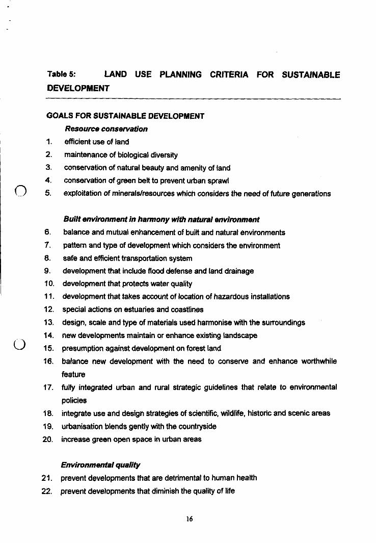
Table 5: LAND USE PLANNING CRITERIA FOR SUSTAINABLEDEVELOPMENT
GOALS FOR SUSTAINABLE DEVELOPMENTResource conservationefficient use of land
maintenance of biological diversity
conservation of natural beauty and amenity of land
conservation of green belt to prevent urban sprawl0 5. exploitation of minerals/resources which considers the need of future generations
Built environment in harmony with natural environmentbalance and mutual enhancement of built and natural environments
pattern and type of development which considers the environment
safe and efficient transportation system
development that include flood defense and land drainage
development that protects water quality
development that takes account of location of hazardous installations
special actions on estuaries and coastlines
design, scale and type of materials used harmonise with the surroundings
new developments maintain or enhance existing landscape
presumption against development on forest land
balance new development with the need to conserve and enhance worthwhile
feature
fully integrated urban and rural strategic guidelines that relate to environmental
policies
integrate use and design strategies of scientific, wildlife, historic and scenic areas
urbanisation blends gently with the countryside
increase green open space in urban areas
Environmental quality
prevent developments that are detrimental to human health
22. prevent developments that diminish the quality of life
16
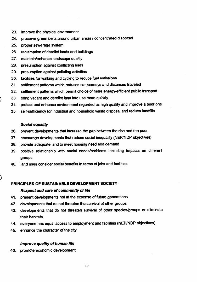
11
11110
improve the physical environment
preserve green belts around urban areas / concentrated dispersal
proper sewerage system
reclamation of derelict lands and buildings
maintain/enhance landscape quality
presumption against conflicting uses
presumption against polluting.activities
facilities for walking and cycling to reduce fuel emissions
settlement patterns which reduces car journeys and distances traveled
settlement patterns which permit choice of more energy-efficient public transport
bring vacant and derelict land into use more quickly
protect and enhance environment regarded as high quality and improve a poor one
self-sufficiency for industrial and household waste disposal and reduce landfills
Social equality
prevent developments that increase the gap between the rich and the poor
encourage developments that reduce social inequality (NEP/NDP objectives)
provide adequate land to meet housing need and demand
positive relationship with social needs/problems including impacts on different
groups
land uses consider social benefits in terms of jobs and facilities
PRINCIPLES OF SUSTAINABLE DEVELOPMENT SOCIETY
Respect and care of community of life
present developments not at the expense of future generations
developments that do not threaten the survival of other groups
developments that do not threaten survival of other species/groups or eliminate
their habitats
everyone has equal access to employment and facilities (NEP/NDP objectives)
enhance the character of the city
Improve quality of human life
promote economic development
17
I
1
I
I
provision of tourism, leisure and recreation facilities
provision of infrastructure e.g. education, health care, roads, sewers
transportation system which reduces pollution and provide safety and convenience
safeguard and improve the amenity of residential districts
control pollution, limit and refuse nuisances such as noise, smells and dust
bring together land use and transportation policies
provide open space in congested urban areas
pedestrian-vehicle separation
cycle-priority routes
provide choices of houses, jobs, shops services and other facilities, without
requiring a significant increase in the distances traveled
avoid developments which provide risks of life and health
improvement of rural housing
consideration for special needs — elderly, disabled, homeless, economically
deprived
Conserve earth's vitality and diversity
encourage conservation-based development
conserve biodiversity by conservation of natural habitats
sustainable uses of renewable resources
presumption against developments which would result in ecological losses
developments are made with special consideration to noise
developments are made with special consideration to air and atmosphere
developments are made with special consideration to water resources
developments are made with special consideration to water bodies
developments are made with special consideration to soil
developments are made with special consideration to geology
developments are made with special consideration to climate
developments are made with special consideration to energy
developments are made with special consideration to human beings
developments are made with special consideration to cultural heritage
developments are made with special consideration to other living organisms
18
Minimise depletion of non-renewable resources
recycling or by substitution of renewable resources where possible
long-term programme for minerals exploitation
preservation of special upland areas as nature reserve or for recreation
Keep development within Earth's canying capacitypopulation level that balance with nature's capacity
79. utilise most versatile agricultural land for food production
Change personal attitudes and practices
0 80. promote local pride by conserving and enhancing natural and built heritage
designation of Areas of Special Value
protection of historic buildings
protection of natural features
protection of features of ecological and archaeological importance
enhance the fabric and appearance of the environment
Provide framework for integrating development and environmentthrough foundation of information and knowledge
through law and institution
through consistent economic and social policies
89. strategic transport and highway facilities
11_.)90. interpret national/regional development policies/objectives for the local strategy
interpret national/regional environmental policies/objectives for local development
references to strategies, policies or proposals of other agencies/authorities which
are related to the environment
clear reference and consideration of strategies and actions of neighbouring
authorities and agencies
clear relations with other types of plans
95. planning the Sustainable City Region in which consideration for resources,
densities and urban forms are made for the region instead of just for one
settlement or city/town
19
STRATEGIC IMPERATIVES FOR SUSTAINABLE DEVELOPMENTRevive growth
stimulate and revitalise urban economic growth and employment opportunities
stimulate the rural economy
new industries, business, retail and other employment-generating and wealth
creating developments
strategic transportation network which considers economy and environment
urban regeneration
indication of priorities for types of economic development
102. maintain character and vitality of town centres and older urban areas
0 103. comprehensive rural development strategy which complements urban development
Change the quality of growth
sustainability, equity, social justice, and security as part of major social goals
traffic calming through traffic management
land use-transportation integrated planning which benefits residents and business
growth that is related to public transport networks
location of new developments that attract trips at points which are capable of acting
as nodes for public transport networks
limitations in town centre car parking
appropriate interchange opportunities between major public transport networks
maintain and enhance open space
balance between the provision of new improved highways, use of traffic
arrangement techniques, provision of transport services
Conserve and enhance the resource base
conserve environmental resources such as clean air, water, forest, soils
114. maintain genetic diversity
115, use energy, water and raw materials efficiently
agricultural land of high productivity are protected
less valuable land are assessed for more beneficial use
planning guidelines for hill lands and forest lands on the urban fringe
more positive about the consequences on the demand for water of future land uses
20
II
I
I
I
I
1
10
Ensuring a sustainable level of population
population policies integrated with economic and social development programmes
such as education, health care
expand the livelihood of the poor with more employment opportunities
Integrate environment and economics in decision-making
plan that is realistic with resources
focus on environmental damage rather than on the symptoms
plan is within resource context, development and market conditions
a realistic plan in resource context and financial abilities of implementing agencies
Source: Dr.Halimaton Saadiah bte. Hashim.
21
6.0 CONCLUSIONS
Guidelines for riverfront development which have been integrated into them the
elements for sustainable development are best prepared in the context of the exact
environment in which the developments are to take place. Consideration for the
functions of the river, socio-economic objectives of the local population, the aspiration of
planners and decisions-makers, and most of all the intrinsic values of the environment
must form the underlying principle for the formulation of these guidelines. What is crucial
is a decision-making process which operates in an integrated resource planning and
management system. The physical development form should conform to the outcome of
analyses which point directions towards a balanced ecosystem for the new environment
to be created. The goal of conserving the present environment as a legacy for future
generations must be the ultimate goal of development.
REFERENCES
Blowers, Andrew (ed.) (1993) Planning For a Sustainable Environment. A Report
By the Town And Country Planning Association. Earthscan Publications Ltd.
London.
Carpenter, Richard A. and Dixon, John A. (1985) Ecology Meets Economics: A
Guide to Sustainable Development. Environment, vol. 27, no. 5, June 1985.
Department of Environment U.K. (1991) Policy Appraisal an The Environment.
HMSA, London.
Department of Environment UK. (1992) Development Plans: A Good Practice
Guide. HMSO London.
Department of Environment UK. (1992) PPG 12. Planning Policy Guidance:
Development Plans and Regional Planning Guidance. United Kingdom.
English Nature (1992) Strategic Planning and Sustainable Development: An
Informal Consultation Paper. Peterborough, English Nature.
7. Halimaton Saadiah Hashim. Phd. Thesis `Integrating Strategic Environmental
Assessment into Malaysian Land Use Planning". University of Newcastle Upon
Tyne, United Kingdom.
22
1
11
in
11
111
1
Holliday, John, (1993) Ecosystems and Natural Resources In Blowers, Andrew
(ed.) (1993) Planning For a Sustainable Environment. A Report By the Town And
Country Planning Association. Earthscan Publications Ltd. London.
International Union for Conservation of Nature and Natural Resources (IUCN),
United Nations Environment Programme (UNEP) and the World Wide Fud for
Nature (WWF) (1991) Caring For the World. A strategy for Sustainable Living.
Gland, Sitzerland.
Rees, Williams E. (1991) "Economics, Ecology and The Role of Environmental
Assessment in Achieving Sustainable Development' s. In Jacobs, Peter and Sadler,
Barry (eds.) Sustainable Development and Environmental Assessment:
Perspetives on Planning For A Common Future. Canadian Environmentati
Assesment Reserarch (CEARC) Ottawa.
The National Conference on UNCED (1992) Summary Recommendations.
National Seminar on The United Nations Conference on Environment and
Development (UNCED). Kuala Lumpur, Malaysia.
Therivel, R.Wilson, Thompson, S,. Heaney, D., and Pritchard, D. (1992) Strategic
Environmental Assessment). Earthscan Publications, London.
Town and Country Planning Act 1976, Act 172.
Town and Country Planning Department, Semenanjung Malaysia
World Commission on Environment and Development (WCED) (1987) Our
Common Future. Oxford University Press, Oxford.
RiverFronDevt-GuideSustDevt
HSH30031998
23
RIVER CLASSIFICATION SYSTEM FOR'RIVER WATER QUALITY MANAGEMENT'
S.L. TongAlam Sekitar Malaysia Sdn Bhd
Suite 13.04/05, Wisma Cyclecarri50350 Kuala Lumpur
ABSTRACT
Water pollution control, or water quality management in a more general sense,which has been based on solely the application of effluent discharge standardsis no longer adequate in face of the rapid pace of socio-economic
111)
development. This paper presents an efficient approach to the river basinwater quality management which involves a river classification system wherethe existing or intended beneficial uses of the river will determine the level ofpollution control or water quality management requirements to be imposed ondevelopment activities. The classification system, which has been developedduring the last decade by DOE and its consultants, is built upon the waterquality criteria and water quality standards formulated for the protection of thevarious beneficial uses of the rivers. Six classes of water quality standardsdefining river water from the highest to the lowest quality have beenestablished, and in each of these classes the capability to support the differentbeneficial uses is also reflected.
The management or control of pollution for rivers or river segments followingthe appropriate water quality and use classification is proposed to be built onwater quality-based or technology-based effluent discharge limits (EDL),depending on the level of control required. Technology-based EDL which isgenerally less demanding in its development, implementation and enforcementis normally adequate for the management of river with minimal pollutionthreats. The water quality-based EDL approach is designed to provide a meansfor the incorporation of more effective protection measures to rivers which arefacing high risks of degradation. Principles for deriving river segments-specific water quality-based discharge limits, approach to the calculation oftotal daily maximum loads and the structure of a permit system will beoutlined.
In the final part of the paper, a stepwise mechanism in implementing the waterquality and beneficial use river classification system will be discussed. Theprincipal steps are: set the targets on priority problems; involve the relevantauthorities, enforcement agencies and the public; establish the integratedsolutions; and choose specific indicators for measuring success.
I Presented at "Bengkel Pengurusan Sungai Negeri Selangor", Kuala Selangor. 29-31 March 1998.
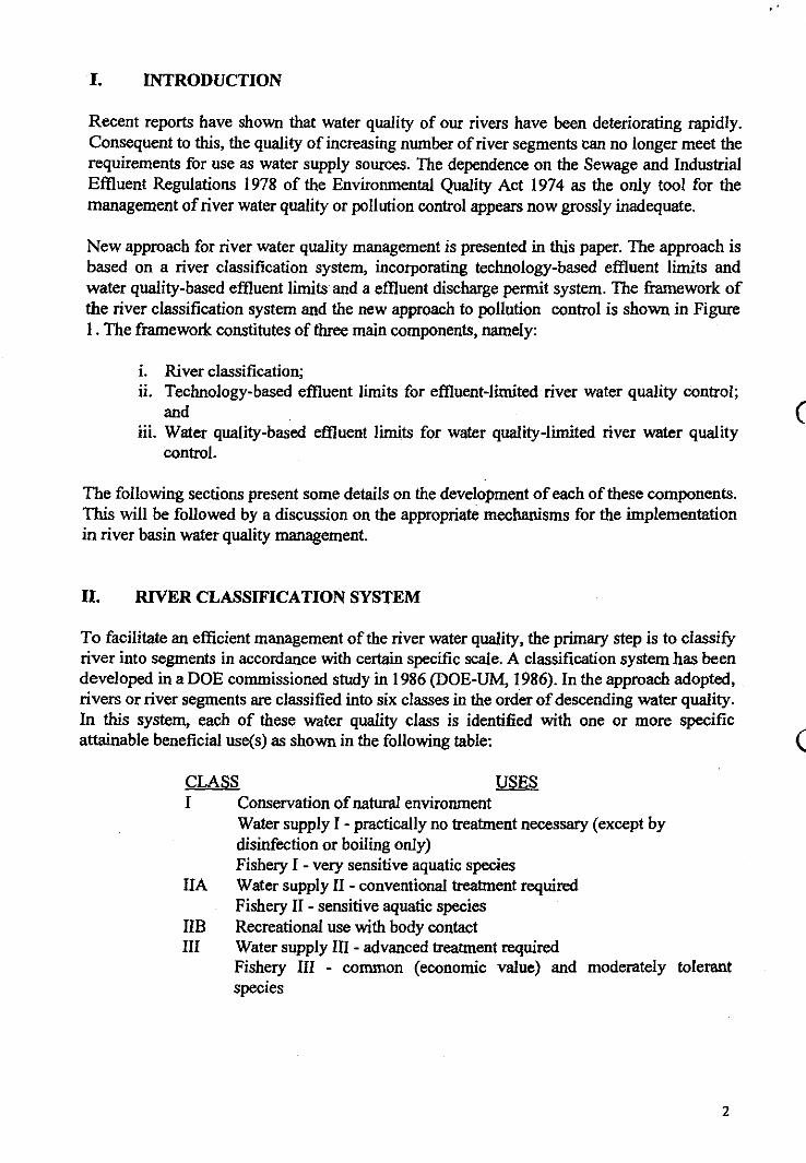
I. INTRODUCTION
Recent reports have shown that water quality of our rivers have been deteriorating rapidly.Consequent to this, the quality of increasing number of river segments can no longer meet therequirements for use as water supply sources. The dependence on the Sewage and IndustrialEffluent Regulations 1978 of the Environmental Quality Act 1974 as the only tool for themanagement of river water quality or pollution control appears now grossly inadequate.
New approach for river water quality management is presented in this paper. The approach isbased on a river classification system, incorporating technology-based effluent limits andwater quality-based effluent limits and a effluent discharge permit system. The framework ofthe river classification system and the new approach to pollution control is shown in Figure1. The framework constitutes of three main components, namely:
River classification;Technology-based effluent limits for effluent-limited river water quality control;and
iii. Water quality-based effluent limits for water quality-limited river water qualitycontrol.
The following sections present some details on the development of each of these components.This will be followed by a discussion on the appropriate mechanisms for the implementationin river basin water quality management.
IL RIVER CLASSIFICATION SYSTEM
To facilitate an efficient management of the river water quality, the primary step is to classifyriver into segments in accordance with certain specific scale. A classification system has beendeveloped in a DOE commissioned study in 1986 (DOE-UM, 1986). In the approach adopted,rivers or river segments are classified into six classes in the order of descending water quality.In this system, each of these water quality class is identified with one or more specificattainable beneficial use(s) as shown in the following table:
CLASS USESI Conservation of natural environment
Water supply I - practically no treatment necessary (except bydisinfection or boiling only)Fishery I - very sensitive aquatic species
HA Water supply II - conventional treatment requiredFishery II - sensitive aquatic species
IIB Recreational use with body contactIII Water supply III - advanced treatment required
Fishery III - common (economic value) and moderately tolerantspecies
1
01111
2
Livestock drinkingIV IrrigationV None of the above
A set of general Water Quality Standard (WQS) limits has been recommended for each of thewater quality classes based on the requirements for the protection of the beneficial use or usesidentified. These WQS are derived from the Water Quality Criteria (WQC) and these areconcentration limits of pollutants or contaminants which have been developed purely basedon scientific knowledge for the protection of specific beneficial uses of ambient water bodies.The general WQS may be modified by taking into consideration the practical and site specificfactors when this is to be adopted for a given river segment. The general WQS consists of 17common parameters and 55 other chemicals and radionuclides.
In the DOE commissioned in 1986, WQC have been developed for the following list ofbeneficial uses:
Domestic water supply;Fisheries and aquatic life propagation;Livestock drinking;Recreational use; andAgricultural use.
Over 120 physical, chemical and microbiological parameters have been studied andappropriate criteria derived for the protection of the above beneficial use (DOE-UM, 1986).
River Classification Procedure
The river classification system based on the six classes of WQS has been applied in a follow-up study for the classification of six rivers (DOE-SMHB, 1989). The six rivers are Sg. Muda,Sg. Perak, Sg. Kelang, Sg. Linggi, Sg. Muar and Sg. Pahang.
The primary steps in the classification procedure involve an evaluation of the existing waterquality with respect to those defined in the six classes in the WQS. The water qualityparameters were divided into three lists. List 1 are basic parameters including dissolvedoxygen (DO), biochemical oxygen demand (BOD), chemical oxygen demand (COD), pH,total suspended solids (TSS) and ammoniacal nitrogen (AN) for which regular monitoringdata were available for most of the rivers. For a given river segment, an overall water qualityindex is calculated based on these parameters to arrive at the appropriate WQS classdesignations.
List 2 includes a number of other important inorganic and organic chemicals andmicrobiological quality. List I classification may be adjusted on examining the status ofcompliacne of the list 2 parameters with the corresponding WQS limits. List 3 parameters(boron and chloride) will be considered if earlier steps indicate class designation below ClassIII in order to confirm if Class IV may be assigned.
The subsequent step to the water quality-based classification is then to assess the existingbeneficial uses and basin-wide pollution loading. A water quality classification value which is
3
lower (e.g. II) than the existing beneficial use(s) (e.g. III) indicates that the water quality isable to sustain higher uses although existing use was only Class III. The river segment shouldthen be classified and maintained as Class II. In the reverse case, a conflict in the waterquality and the beneficial use(s) exists which would call for actions to strengthen control onthe sources of pollution contributing to the poor water quality. The river segment is basicallyClass III and hence classified as such. However, there should be immediate plans to improveon the water quality to meet the requirements of the existing use(s) and eventually upgrade itto Class II.
The first version of the classification procedure was further expanded in an extension of theRiver Classification Programme conducted by a five-university team (Joint Water QualityConsultancy Group) in 1992 involving the classification of a further ten river basins. The tenrivers consist of eight rivers from Peninsular Malaysia and one each from Sabah and Sarawakof East Malaysia: Sg. Selangor, Sg. Bemam, Sg. Kelantan, Sg. Sugut, Sg. Perlis, Sg.Juru/Perai, Sg. Terengganu, Sg. Sarawak, Sg. Melaka and Sg. Rompin (DOE-Joint WaterQuality Consultancy Group, 1994). The extended river classification procedure requires thesetting up and critical evaluation of three sets of river basin inventory which are listed as
follows in order to arrive at an aggregate class designation:
inventory of existing beneficial use, land use, hydrological conditions,population and socio-economic development;inventory of existing water quality and pollution sources and loads; WQIs of agroup of common parameters and those of individual parameters were used;
iii. inventory of the aquatic ecology; biological indices were estimated if datawere sufficient.
In addition to the specific procedure to the classification established previously based onexisting river water quality, other consideration has also been included. The overallprocedures are summarised as follows:
Rivers are divided into segments determined by the existing water qualitymonitoring stations of the National Water Quality Monitoring Programme ofDOE and additional stations recommended in the study;Each river segment is designated an appropriate class value according to theexisting beneficial use(s) and a geomorphic classification based on anintegration of Strahler stream order and type of landuse; if more than onebeneficial use exists, class value for the highest use is adopted;Designate an appropriate class value also to the given river segment based onthe present water quality of the monitoring station immediately down-streamof the segment;If the class designations of the above are in conflicts, the water quality shouldbe reexamined. If the WQS parameter limits exceeded are not important to thehighest present beneficial use, the beneficial-use class value will bemaintained, otherwise the class value determined by the water quality shouldbe adopted.
v.
The class designation obtained from the above is then compared with the classvalue derived from the aquatic ecological evaluation. Two types of biologicalclassifications have been employed depending on the availability of biological
0I
4
monitoring data The first type made use of field data on species diversityindex (H) for the plankton communities calculated using the formula ofShannon-Wiener (Shannon and Weaver, 1949; Wilhm, J.L., 1970). The secondtype is based on the index of Saprobic condition (Pantie and Buck, 1955),estimated from information on the number and kinds of indicator organismsfound in the water. If a conflict occurs, the beneficial use and water qualityinformation will be reexamined; if these are within narrow limits, then thehigher class from biological classification is used. In. such instances, thepotential pollutant loads will be reassessed to ascertain if the class designationcan be sustained. Class designation from Step iv. will be maintained if itindicates higher class than the ecological classification.
Following the class use designation, WQS are reviewed and modified wherever necessary andset for the specific river segments. The WQS established shall form the basis for prescribingeffluent discharge limits for point sources contributing to the river segments, and also informulating non-point source control strategies.
IIL DEVELOPMENT OF TECHNOLOGY-BASED AND WATER QUALITY-BASED EFFLUENT LIMITS
The outputs of the river classification are: (i) designation of rivers or river segments intospecific WQS classes; and (ii) information for decision making on the level of pollutioncontrol requirements. Two levels of pollution control are suggested depending on whether thewater quality of the river segment can readily meet the WQS limits, considering existing andpotential inputs from all point and non-point sources for a reasonable period projected (e.g. inthe order of 5 years). Rivers or river segments which are at risk of deterioration in the 5-yearperiod will be designated as water-quality limited, or otherwise as effluent-limited. Foreffluent-limited rivers or river segments, water quality control will be based on technology-based effluent discharge limits (TEDL). Whereas for water quality-limited rivers or riversegments, water quality-based effluent discharge limits (WQEDL) will need to be establishedand applied for the control of the water quality. The designation of a river or river segmenteither as effluent-limited or water quality-limited should be based on river monitoring andassessment findings. The development of TEDL and WQEDL proposed is based on similarapproach adopted by the US EPA for its NPDES (National Pollutant Discharge EliminationSystem) Permit System (US EPA, 1996).
Establishing Technology-Based Effluent Discharge Limits
The technology-based effluent discharge limits should consider the technology available forthe treatment of sewage and industrial discharges. The TEDL sets a minimum level oftreatment for industrial and sewage point sources based on currently available treatmenttechnologies while allowing the discharger to use any available control technique to meet thelimitations.
For industrial sources, effluent limitations guidelines should be developed by the FederalDOE based on the demonstrated performance of a reasonable level of treatment that is withinthe economic means of specific categories of industrial facilities. If this is not available, the
5
individual river basin management authority would have to use the same performance-basedapproach and best professional judgement to set the relevant TEDL.
The conventional or existing effluent discharge standards, such as Standard A and Standard Bunder the Sewage and Industrial Effluent Regulations 1979, can be used as a starting pointwhile establishing TEDL for specific sewage treatment or industrial plants.
Toxic pollutants which are not in the Standard A and Standard B list should be set based onthe water quality-based effluent discharge limits requirements.
Establishing Water Ouality-Based Effluent Discharge Limits
The WQS classification established for a river or river segment represents the minimumrequirement of water quality protection for the river or river segment. Stringent waterpollution control is necessary for some rivers due to the inability of the existing water qualityto support the designated or anticipated beneficial uses of the rivers. In establishing waterquality-based effluent discharge limits (WQEDL), the impact of every proposed and existingsurface water discharge on the quality of the receiving water must be considered. The rivermanagement authority will need to develop specific methods for predicting water qualityimpacts from discharges and procedures for setting the WQEDL for this purpose.
The following is a summary of the procedures proposed for setting the site specific WQEDL:
Survey and evaluate the pollution sources (include both point sources and non-pointsources) and existing water quality of the receiving waters; select pollutants forlimitations;
Based on the existing water and trends, classify the water sources in accordance with thebeneficial uses attainable;
Adopt appropriate set of water quality standards for the protection of the identified uses;
Determine the relationship between the waste loads, from both point sources and non-point sources, and the water quality; based on the designed low flow, estimate thepermissible waste loads for each constituents;
Establish a control plan for the discharges from non-point sources;
Based on the permissible pollutant loads and the actual discharge, calculate the totalpermissible loading;
Perform analysis based on best technical or economical approach, work out the waste loaddistribution plan;
Issue licence to discharge where effluent parameter limits are specified;
Establish enforcement monitoring requirements.
In the estimation of the waste load allocations, the predication should be based on the natureof the pollutants as follows:
for biodegradable organic matters, the assimilative capacity of the receiving water will beconsidered;
for non-biodegradable organic matter, dissolved inorganic salts and suspended materials,the main consideration is on the dilution effect;
for heated water discharge, the heat dissipation and heat balance of the water bodies willbe considered.
Total Maximum Daily Loading and Waste Load Allocation
An important step in setting the WQEDL is the determination of the total maximum dailyloading (TMDL) and waste load allocation (WLA). An approach similar to that adopted bythe US EPA for its NPDES Permit System (US EPA, 1991) is presented. In the US EPAguidelines for the TMDL process, the total loading capacity (LC) or total maximum dailyload (TMDL) is defined as the greatest amount of pollutant loading that a waterbody canreceive without violating water quality standards. A load allocation (LA) is the portion of theTMDL that is allocated to one of its existing or future nonpoint sources of pollution andnatural background. The sum of the individual WLAs for point sources and LAs for nonpointsources (including natural background sources and tributaries) plus the margin of safety(MOS) is equivalent to the TMDL (i.e. TMDL = LC = WLA + LA +MOS).
The guidelines of US EPA (1991) further elaborate that TMDL studies utilising fieldmonitoring data and predictive models provide quantitative information to assist managers inmaking effective decisions to protect water quality. Models and water quality equations areused to establish cause-and-effect relationships correlating incremental changes in streamwater quality to changes in pollutant loading. From this correlation, optimum and desirable,but not required cost-effective treatment levels can be specified to achieve water qualitystandards and criteria. The MOS can be included implicitly in the TMDL model calculationsto account for the uncertainty about the relationship between the allocated waste loads andloads and the predicted quality of the receiving water body. A reserve capacity for futuredevelopment can be included in the TMDL at this stage. Wastewater treatment pant designerscan then evaluate various combinations of alternative unit processes to select an optimumtreatment scheme to meet the requirements of the WLA. Likewise, land use planners andengineers may need to analyse various management scenarios to meet the requirements of thenonpoint source LA. This analysis may include an evaluation of the cost-effectiveness ofdifferent combinations of management practices (BMPs)
Developing and Issuing an Effluent Discharge Permit
Figure 2 shows an example of the steps involved in developing and issuing an effluentdischarge permit under the NPDES Permits System of US EPA (US EPA, 1996). Theprincipal steps are: develop technology-based effluent limits; develop water quality-basedeffluent limits; develop monitoring requirements for each pollutant; develop special andstandard conditions for the permit; etc.
7
II
IV. MODE OF IMPLEMENTATION
The implementation of the water quality and beneficial use river classification system on ariver basin-wide basis should include the following steps:
Set Target on Priority Problems
All significant problems in watershed should be identified and addressed, not just theproblems that are familiar or easily solved. Monitoring provides critical data for this effort.The priority problems those which may pose health or ecological risks in a river basin suchas:
Industrial wastewater discharges; sewage wastewater; stormwater; nonpoint sourcerunoff or seepage; atmospheric deposition; habitat alteration; wetlands loss;hydrologic modification etc.
Involve Relevant Parties
The relevant parties may include: State environmental, public health, agricultural, andresource agencies; local authorities; Federal agencies; public representatives; wildlife andconservation organization; industry sector representatives; water supplies; academiccommunity. Working as a task force, the relevant parties may reach agreement on goals andapproaches for addressing a river basin's problems, the specific actions to be taken, and howthey will be coordinated and evaluated.
0
Establish Integrated Solutions
Selected tools are to be applied to solving the river basin's problems, according to the plansand roles established through relevant participating parties agreement. Coordinated actionmay be taken in such area as:
Voluntary source reduction (e.g., waste minimization, BMPs); permit issuance andenforcement; standard setting; direct financing and incentives; education and technicalassistance; critical area protection; ecological restoration; remediation ofcontaminated soil; emergency responses to leaks or spills; effectiveness monitoring.
Choose Indicator to Measure Success
The relevant parties should agree early in the project on ecological and administrativeindicators that will demonstrate progress. These measures are tracked throughout the projectby water quality monitoring and other types of data gathering.
8
I.
References
DOE-UM, 1986. Water Quality Criteria and Standards for Malaysia, Vol. 1 - 12.Department of Environment of Malaysia, Kuala Lumpur, Malaysia.
I DOE-SMHB, 1989. Development of Criteria and Standards for water Quality (Phse II), FinalReport. Department of Environment of Malaysia, Kuala Lumpur, Malaysia.
I DOE-SMHB, 1993. Development of Criteria and Standards for water Quality (Phse III),Final Report. Department of Environment of Malaysia, Kuala Lumpur, Malaysia.
DOE-Joint Water Quality Consultancy Group, 1994. Classification of Malaysian Rivers, Vol.- 12. Department of Environment of Malaysia, Kuala Lumpur.
Pantle, R. and Buck, H. 1955. Die Biologische Uberwachung der Gewasser and dieDartellung der Ergebnisse. Gas and Wasserfach 26, 604.
Shannon, C.E. and Weaver, W. 1949. The Mathetical Theory of Communication. TheUniversity of Illinois, Urbana, Illinois. 117 pp.
US EPA, 1980 Water quality criteria documents; availability. Federal Register, 45:79318-79379, November 28, 1980.
US EPA, 1991. Guidance for Water Quality-Based Decisions: The TMDL Process.Washington, DC, USA.
US EPA, 1996. U.S. EPA NPDES Permit Writers' Manual. Washington, DC, USA.
J.L., 1970. Range of diversity index in benthic macro-invertebrate population. J.Water Pollution Control Federation, 42, R221-R224.
9
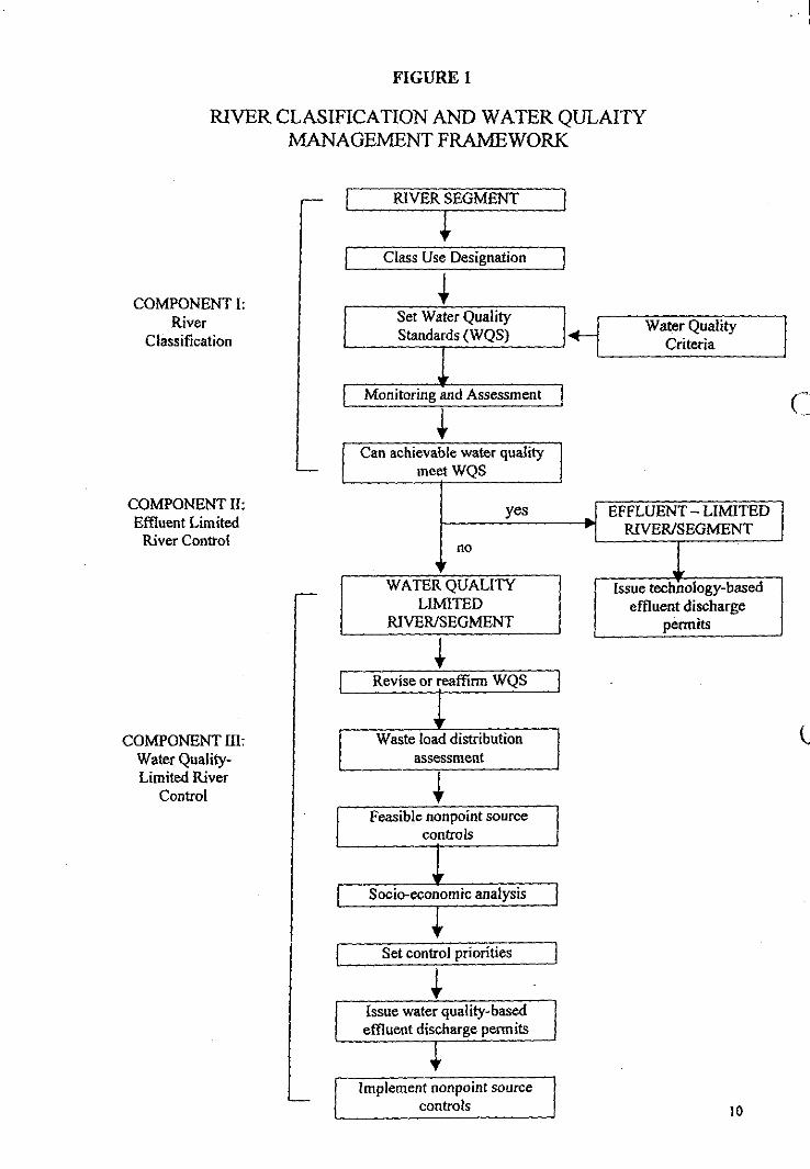
FIGURE 1
RIVER CLASIFICATION AND WATER QULAITYMANAGEMENT FRAMEWORK
IRIVER SEGMENT
Class Use Designation
COMPONENT I:Set Wa er QualityRiver Water Quality
Classification Standards (WQS) Criteria
IMonitoring and Assessment
Can achievable water qualitymeet WQS
COMPONENT H: yes EFFLUENT — LIMITEDEffluent Limited
River ControlRIVER/SEGMENT
no'V
WATER QUALITY Issue technology-basedLIMITED effluent discharge
RIVER/SEGMENT permits
Revise or rea km WQS
COMPONENT Waste load distributionWater Quality- assessmentLimited River
ControlFeasible nonpoint source
controls
V Socio-economic analysis
Set control priorities
JIssue water quality-basedeffluent discharge permits
Implement nonpoint sourcecontrols 10
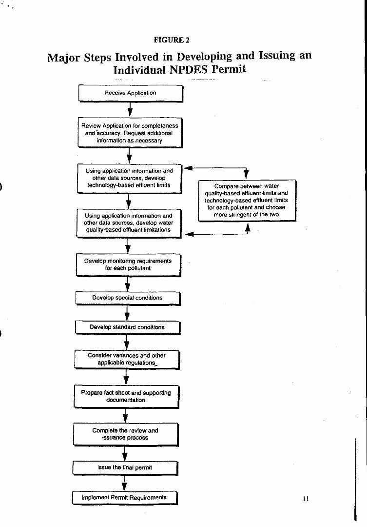
I
Compare between waterquality-based effluent limits andtechnology-based effluent limitsfor each pollutant and choose
more stringent of the two
Review Application for completenessand accuracy. Request additional
information as necessary
Develop standard conditions
Receive Application
Using application information andother data sources, develop
technology-based effluent limits
Using application information andother data sources, develop waterquality-based effluent limitations
Develop monitoring requirementsfor each pollutant
Develop special conditions
Complete the review andissuance process
Consider variances and otherapplicable regulations
Prepare tact sheet and supportingdocumentation
FIGURE 2
Major Steps Involved in Developing and Issuing anIndividual NPDES Permit
Issue the final permit
Implement Permit Requirements I I
"MONITORING PROGRAM-ESSENTIAL PREREQUISITE FOREFFECTIVE OVERALL RIVER MANAGEMENT"
By: Prof. Ir. Dr. Abdul Aziz IbrahimDirector General,National Hydraulic Research Institute, Malaysia (NAHRIM)Jalan Ampang, Kuala Lumpur
1.0 SYNOPSIS
This paper presents the major elements of the synthesis of the working plan of pilotEnvironmental Monitoring Programs (EMP) initiated at several sites in thecountry. It begins by identifying the major components and drivers ofdevelopments within the river or drainage basin. It then outlines the importantimplications of these developments on natural resources (i.e water) in terms ofimpacts in three key areas: water quality, physical deterioration, and sustainabilityof the hydrological and ecological ecosystems. The monitoring program isdiscussed in details covering goals, scopes, organisation, legislations andguidelines, issues, and implementation methodologies and technologies.Generally, the paper discusses EMP in the context of subject matters covering thedisciplines of hydrology, sedimentology, geomorphology, ecology, terrestrial andaquatic ecosystem modelling and GIS at local and regional perspectives.
2.0 INTRODUCTION
Water is a key element of nature and life and river and stream are the natural watercourses. Mankind could not exist without water intakes, and all biological andindustrial processes depend on water. Water via rivers also sustain a multitude ofuses for mankind conveniences: flood conveyance, navigation and transport,pollution dispersion and recreation. Water also possess a natural power that shapesour planet by influencing the hydrologicle cycle and the associated physio-geomorphology processes, with large regional and seasonal diversity and withfloods and draughts, causing frequent natural disasters worldwide.
Malaysia's population growth and distribution show marked tendency towardsnucleaus concentration in urban areas and as a result the need for water grows morethan proportionally. With the predictions that more towns and cities are increasingin extent and size more complex urban water needs are foreseen with consequentialbreaching of the limits of water availability. In year 2000, the demand for waterwill reach 15 billions cubic metre (Ref: 2).
Worksyop Pengurusan Sungai Negeri Selangor, 29 - 31 Mac. 98
In the effort to meet the increasing demands for water, the government hasimplemented several water schemes and gradually these schemes graduated fromlocal to regional scale as the need arises for transferring water resource from water-rich states to water-starve states. This result in cases where separation of watersupply and water use take place in two different regions and even states (e.g.Penang and Kedah) with consequential provision of long distance and costlyconveyance scheme. As a result, water resource (i.e. water) in Malaysia is nowtraded as a commodity. It is not surprising therefore that water privatisationprojects are on the increase in this country.
In order to operate a successful water supply business, the company need to "own"and manage the source - the rivers. The reality only dawn on the operator onlylately when attention was focused on the worse water crisis in Selangor mainly dueto bad condition of one of its major water supply arteries - Sg. Langat.Indescriminate polluting of the river (e.g. the discharge of domestic and untreatedsewage into the water course), lack of enforcement, the absence of concerted effortin R&D and monitoring program, and lack of vision on the part of parties entrustedto manage the resource are factors responsible for the incidence in addition toproblems generated by several riverine settlements, a host of factories, agriculturalprojects, construction sites, and animal farms located along the river. The pollutionlevel in this river was a major cause for concern as it is an important source ofwater supply for Kiang Valley.
All these factors can be lumped into or attributed to one category of organisationalfunction - management, to be more specific river/resource management.Environmental issues are closely linked to water supply development and the coreissue in river management. Ideally, the stretches along the river intended fordevelopment shall have management plans which define all developments andobjectives. The four main management plans that must be considered are:resources tagging, resources management and protection, types ofdevelopment/land use, research and monitoring, and administration ormanagement. Presently, the Environmental Impact Assessment (EIA) order is aholistic approach in identifying potential problems and their impacts and usedextensively to regulate development project and provide guidelines on control andabatement measures. Assessing EIAs on a project by project basis has been provennot providing a complete picture on which well informed decisions can be madeand in most cases lacking emphasis on long-term preventive measures such ascomprehensive basin or catchment management and environmental monitoring.These proactive measures which take a macro and long-term perspective ofdevelopment along the river are practically neglected and rarely appreciated.
Worksyop Pengurusan Sungai Negeri Selangor, 29 - 31 Mac, 98
Eventhough have been designed and proposed, working plans on intensive resourcemanagement and subsequential research and monitoring still remain in its initialstage of implementation. It is projected that with the combination of a propermanagement and monitoring plan and the strict enforcement of existing legislationsempowered to several agencies and local authorities, there shall be no reason whyour rivers and its catchment areas should remain polluted when we have so muchlegal authority to punish offenders and technical, manpower, and financial meansto implement various relevant plans.
On this score, this paper is written with the principal goal of providing advice onscientific and technical opportunities in the realm of river/drainage basinenvironmental monitoring program that could be pursued through an inter-agencies, across-state boundaries collaboration.
3.0 ENVIRONMENTAL MONITORING PROGRAM- OBJECTIVES AND SCOPES
The products of this program will yield many potential benefits, from the moreacademic (river sediment load, erosive potential, the role of river flow on floodingphenomena) to the applied (assessing broad-scale features of water pollution anddrinking water supplies; predicting associated changes in riverine fisheries,predicting changes in volumetric potential as a consequence of regional changedue to development along the river stretches). An enhanced R & D effort, databaseenrichment and monitoring capability are seen as crucial as rapid increases inhuman population, urbanisation, land cover change, and pollution loading withinthe river catchment and downstream areas, all represent real critical threats to thesustainability of the country freshwater as well as estuarine zone systems. Theseproblems and the intended program are likely to continue well into the nextmillenium.
Accepting this impending reality, the principal goal of the monitoring programshall realises several other supporting objectives, namely the identification of keyscientific issues and opportunities, the design of strategy for projecting futurebehaviour of the area (i.e. drainage basin),the setting up of database and archive,and the promotion of collaborative, integrated inter-agencies and inter-statesapproach of management of the drainage basin.
3.1 Objectives as Stipulated by Laws
The Environmental Quality Act requires that the triple goals of prevention,
Worksyop Pengurusan Sungai Negeri Selangor, 29 - 31 Mac, 98
abatement, and regulation of environmental impacts be achieved for alldevelopment projects within the river/drainage basin through periodic, systematic,documented, and objective evaluation. These need to be implemented via pre-project Environment Impact Assessment (EIA) monitoring. In this regard, the EIAis conceived as a planning tool for selecting project options, identifying appropriateabatement and mitigation measures, assessing residual impacts, and determiningenvironmental costs and benefits associated with the proposed development withinthe drainage basin. A comprehensive and coherent Environmental ManagementPlan (EMP) shall be used as a tool to ensure all pertinent issues and associatedenvironmental impacts are adequately addressed and monitored throughout thevarious phases of project or projects implementation (construction and post-construction operations) within the basin. Towards this end, various environmentalmonitoring programs are built in into the EMP, aimed at ascertaining theeffectiveness of the proposed mitigation measures and at monitoring the temporaland spatial changes in the physical, chemical, biological and social environments.
Realizing the fact that the environment (or ecosystem) of the drainage/river basinis highly dynamic, it is to be borne in mind that the proposed EMP will not be astatic one. The program will be designed to allow a great deal of flexibility foraccomodation of potential changes. It will gradually evolve through periodicreview and alteration to accomodate the changing demands of the environment asthe project/development cycle unfolds.
As outlined in several relevant guidelines (and legislations) published by theDepartment of Environment (DOE), the responsibilities and actions required of theproject proponent, his project manager or implementing body are:-
Allocating institutional/administrative responsibilities for planning andmanagement of environmental requirements. The results of the EIA are tobe applied to shape the project/development and influence theimplementation elements, stages and direction;
Allocating responsibility to execute mitigative action to the project managerand/or the contractor responsible for the development implementation;
c) Implementing planned program of monitoring to check the effectiveness ofvarious mitigating plans, and to modify or implement additionalplans/measures, to improve, correct or overcome the identified impact inquestion;
Worksyop Pengurusan Sungai Negeri Selangor, 29 - 31 Mac, 98
1
1
1
1
Appointing relevant research organisation, experts or consultants to assistthe project proponent if in-house capability is not available;
Ensuring that identified, recommended mitigation measures are incorporatedin the implementation plans (e.g design) and contract documents;
0 Allocating an adequate budget for the implementation of the EMP; and
j)
Actively promoting and practising habitat and species conservation.
Thus, the issue of water sustainability of the country hopelly can be addressedand pursued through an inter-program element collaboration as stipulated by EMP.A vested interest by water concession holder or State Government could berealized by articulating the connection between well-designed sediment survey, forexample, will help prevent the uselessness of a dam structure jeopardized by landdegradation in the upper catchments, and provide a catalyst for improving landmanagement practices in the surrounding areas of river/drainage basin.
3.2 Scopes of the Environmental Monitoring Program (EMP)
Developments within the river/drainage basin in this country have frequently ledto human disturbance of the water cycle which affecting both water flows and thetransport and evolution of sediments, carbon, and nutrients in aquatic ecosystems.This in turn has led to significant, unreversable physical changes to the riversystem itself and the transport of constituents from the upper reaches to theestuarine areas with poorly known impacts on regional bio-geochemistry. Despiteits enormous importance to human survival, the mechanism linking between theupper landmass, river systems, and the estuarine/coastal environment is lessunderstood. The specific manner in which human has modified these mechanismsrequires further study and shall be an important element of the EMP. The EMPshall address the full dimension of anthropogenic change relating to water onseveral aspects: potential physical interactions between flow-soil-structures,expanding management and conversion of landscapes, and an ubiquitous alterationof the hydrologic/water cycle for activities such as irrigation, flood control,hydroelectric power production, industrial withdrawal, and waste processing.
The issue of physical hydrologic and ecological ecosystems change (e.g sedimenttransport, water flow, etc) is therefore of direct relevance to the broader questionof contemporary regional change, with obvious policy implications.Anthropogenic effects such as impending climate change (e.g. due to El Nino
Worksyop Pengurusan .Sungal Negeri Selangor, 29 - 31 Mac, 98
effect resulting in prolonged dry spell), drainage regulation, degradation in waterquality and catchment area and increased land and river erosions will collectivelyinfluence the long-term functionality and sustainability of inland and estuarineecosystems to supply drinking water, support fisheries, regulate floods andtransport and process wastes. The reality that a large proportion of the country'spopulation resides within the river basins (e.g Kiang Valley, Kuantan, Alor Setar,Kuala Terengganu, Johor Bahru and others) makes the issue of land-river-estuarinezone linkages important and relevant to future well-being of the country. A welldesigned, well-executed, and well-managed EMP directed at predicting thedirection, magnitude and impact of human activities within the river/drainage basin(e.g in Selangor) could provide, in a long-term an important indicator or early-warning mechanism for an effective management of our rivers.
4.0 THE EMP FOR RIVER MONITORING
The EMP for river will span a science that is broad, interdisciplinary, andcomplex. Interconnections exist among the more traditional realms of terrestrialecosystem analysis, hydrology, climatology, geomorphology, land management,river hydraulics, and sedimentology. Additionally, due consideration must begiven to a wide spectrum of anthropogenic impacts including those associated withpoor land use planning and massive land cover change (already happening inmassive scale in the State of Selangor and Negeri Sembilan), and the still poorlyquantified effects due to poor management of natural resources within the riverbasin. These represent issues and the scope of the EMP pertinent to relevantactivities derived from these issues is given and illustrated in Figure 1.0.
Figure 1.0 which basically provides a conceptual framework for the preparation ordesign of an EMP identifies three environment elements (constituents, domain, andclassification scheme) and four primary elements of EMP (class of tools,objectives, specific tools,. and institutional issues).
This working plan framework is in line with the primary elements of the acceptableEMP (Reference 1), which are:-
an organisational setup tasked with clear responsibilities in ensuring that thepractices, procedures, processes and resources are either available or in-place to implement, maintain and sustain effectively the system of rigorousand systematic environmental management;
legislative provisions/administrative guidelines for compliance;
iii) environmental monitoring and measurement of selected representative
Worksyop Pengurusan Sungai Negeri Selangor, 29 - 31 Mac, 98
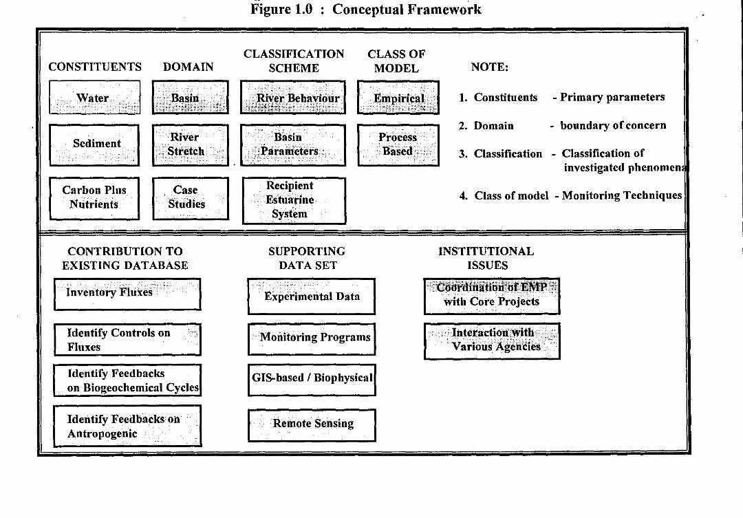
CONTRIBUTION TOEXISTING DATABASE
Identify Feedbacks onAntropogenic
Identify Feedbackson Biogeochemical Cycles
Inventory Fluxei
I
Identify Controls onFluxes
SUPPORTINGDATA SET
Experimental Data
IMonitoring Programs
IGIS-based / Biophysical
Remote Sensing
INSTITUTIONALISSUES
Coordination " EMPIwith Core Projects
Interaction withVarioUs Agendies
a SI =I MIN MS MO Ile IND fin Ma MI Mir I= INN OM Ma OM al asFigure 1.0 : Conceptual Framework
CONSTITUENTS DOMAINCLASSIFICATION
SCHEMECLASS OF
MODEL NOTE:
Water Basin River Behaviour Empirical Constituents - Primary parameters
Domain - boundary of concern
Sediment River Basin ProcessStretch Parameters Based Classification - Classification of
investigated phenomena
Carbon PlusNutrients
CaseStudies
RecipientEstuarine Class of model - Monitoring Techniques
System
II
11
I
parameters relevant to addressing, among others, water quality, rivermorphology, river hydraulics, anthropogenic issues and impacts, and
iv) reporting sequence and action plans in response to unexpected incidences ofabnormal behaviour/manifestation in the course of the project development.
Each of the above salient elements of the proposed EMP framework is discussedsequentially in the following sections.
4.1 Organisational Structure
While the Environmental Monitoring Program (EMP) is to be implemented by thesuccessful contractor of the development work in accordance with the provisionsof work in accordance with the provisions of ISO 14001 (1996): EnvironmentalManagement System, its planning and overall supervision is entrusted to theCorporate Environmental Management System (EMS) within the organisation ofthe Project Proponent. The interface between the implementing and oversightparties in the bipartite arrangement shall through the EMS representative, who isnormally the Project Director, and the Environmental Management Representative(EMR) in the employ of the contractor. A typical setup and interaction of such astructure is depicted clearly in Figure 2.0.
Apart from working full-time and having technical competence in environmentalscience with a minimum qualification at the diploma level, ideally the EMR shallbe vested with the following authorities or powers:-
liaising with the relevant government agencies and the EMS representativeon matters associated with the environment and implementation andperformance of the EMP, respectively.
planning and coordinating environmental training and awareness programsto all site staff to be conducted by an environmental scientist registered withthe Department of Environment (DOE), Malaysia;
identifying, recording, controlling, and initiating and verifyingimplementation of preventive/corrective actions to address incidences ofenvironmental problems and non-conformance of the EMP.
The EMP document must be submitted to the DOE within one (1) month and becertified within six (6) months from the date of award. In addition, the contractor
Worksvop Pengurusan Sungai Negeri Selangor, 29 - 31 Mac, 98
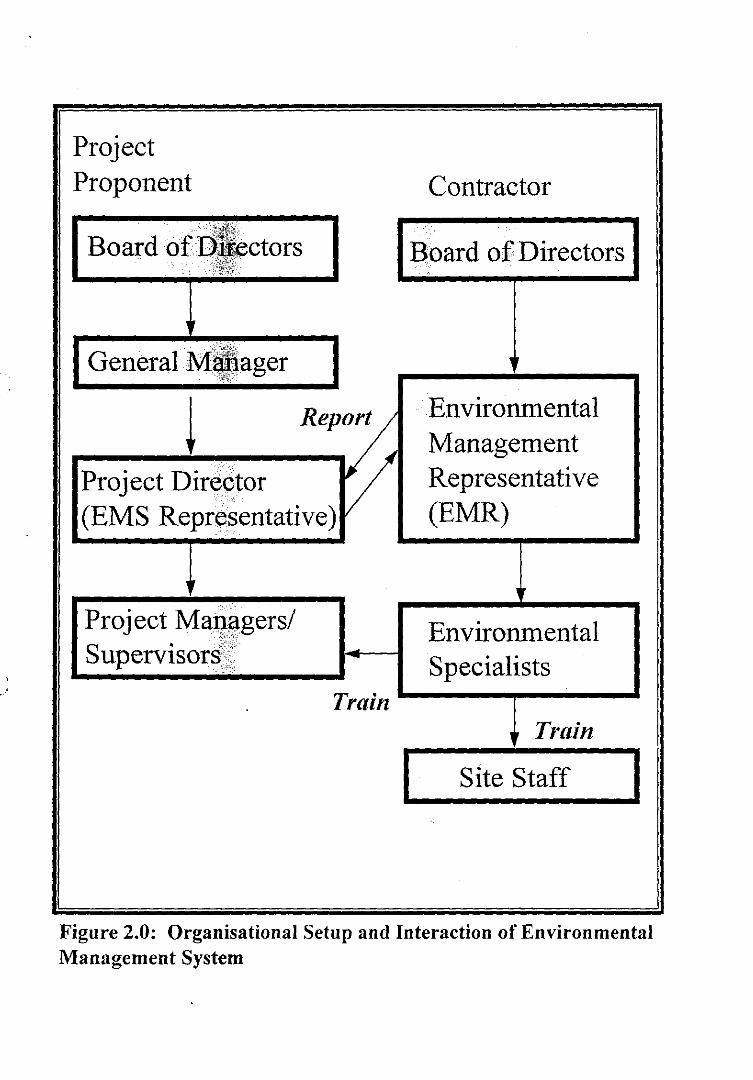
Figure 2.0: Organisational Setup and Interaction of EnvironmentalManagement System
ProjectProponent
Board of Directors
Contractor
IBoard of Directors
IIII
1
I
I
1
1
EnvironmentalManagementRepresentative(EMR)
EnvironmentalSpecialists
Project Managers/,Supervisors
Train
IGeneral M ager
Report
Project Director(EMS Representative)
Train
ISite Staff I
is required to provide the details of the procedure for Environmental Audit and toadhere to submission requirements.
4.2 Legislative Provisions/Administrative Guidelines (Reference 1)
In implementing the proposed EMP, the contractor shall comply with the relevantFederal and State Laws, Regulations and Guidelines (Table 1.0), environmentalregulations enacted pursuant to the Environmental Quality Act, 1974 and itsamendments (Table 2.0),and special considerations that constitute a set of bestmanagement practices pertinent to the type of development work undertaken. Inaddition, the contractor shall adhere to the Terms of Conditions of Approval issuedby DOE on the proposed development work or works. The entries in the abovetables are not meant to be exhaustive and the contractor shall be responsible forensuring that all applicable laws, regulations and guidelines are complied with.
4.3 Environmental Monitoring, Measurement and Reporting
The various environmental monitoring programs that are aimed at effectiveimplementation of the mitigation measures and timely management of crisesdepend on the potential issues/impacts arising from the proposed developmentwithin the drainage/river basin. Table 3.0 indicates potential impacts/issues thatmay arise and the spatial coverage of the monitoring effort and temporalrequirements for record and reporting purposes are also listed therein.
Table 3.0 shows that the programs require interdisciplinary framework for theconduct of environmental inventoring, measuring and reporting exercises. Theprograms require the identification and agreement on research priorities, thedevelopment of standardized research, inventory, measurement, and reportingmethodologies, the coordination of inter-groups/inter-agencies field campaigns andresearch efforts, and the exchange of data and results.
The requirements of the EMP for river basin can be generalised as follows:-
a) Establishment of key scientific issues and opportunities
our current understanding of the hydrological and ecological processes andchanges within the drainage/river basin due to human disturbances is derivedessentially from brief case studies on individual river systems. Inventories ofriverine ecosystems, if there is any, have been based on this information. Muchmore need to be done to develop techniques to extend our understanding to
Worksyop Pengurusan Sungai Negeri Selangor, 29 - 31 Mac, 98
estuarine, upper reaches, and catchment scales using state-of-the art tools formonitoring and modelling projected changes. The first step in this process is theidentification of a set of key, answerable scientific questions that can be addressedwith the EMP context and in a short-term (says 3 - 5 years) time frame Questionssuch as what are the physical, chemical, and biological controls (including naturaland anthropogenic), on the fluxes of water, sediment, etc in the basin cascade; whatare the feedbacks of changes in river basin on human society and onbiogeochemical cycles; what are the quantities of sediment of the riverborne fluxesas a result of physical changes due to development? are important.
Development of strategy for establishing drainage basin simulation
this stage will address or provide the organisational capability of predictingthe physical and biological scenarios within the basin in the with development andthe without-development conditions. At this stage, several numerical models shallbe identified capable of simulating drainage basin water dynamics in the contextof the sediment transport and processing of waterborne materials from thecatchment upper reaches to the estuarine area at localised and basin scales. Themodels shall be also able to simulate the various conditions within the basin atdifferent time frames (for e.g. in the next 5, 10, 30 or 50 years).
The use of numerical hydrologic and ecological models as a predictive tool inenvironmental monitoring and impact assessment is now favoured by theDepaitment of Environment (DOE) due to their predictive capability.
Establishment of the data requirements to support model calibration,testing, and validation
the types of ecological and hydrological characteristics which can mostlikely serve as reliable indicators of change will provide important benchmarks inour understanding of phenomena happening within the domain of the drainage orriver basin. The proposed models, which preferably shall embody spatial andtemporal variability, need data of a dynamic perspective (e.g water levels, andfluxes). It is then advocated a two-phased approach for developing comprehensivedatabase of fluxes over both space and time The first phase should be devoted todatabase development which will provide necessary inputs for creating a basicmodels. Assembling, assessing, and improving the existing data on variousparameters will contribute to a better quantification of various riverine phenomenafrom a purely empirical standpoint. The second stage should involve model setup,calibrating, and validating scaled models that can be applied with geometric or
Worksyop Pengurusan , Sungat Negeri Selangor, 29 - 31 Mac, 98
geographic-specificity and capable of simulating and predicting present and futurebehaviour of various flow phenomena within the drainage/basin area.
Model setup requires initial input of data on boundary conditions - the river/basinbottom bathymetry, river water levels and fluxes , at all the external and internalmodel boundaries as well as initial conditions at the beginning of model runs.Once the model setup is completed, the model performance needs to be validatedagainst measured field data (e g bottom roughness due to sediment size andvegetation type, and eddy viscosity which represents the extent of turbulenceexchange in the flow). The comparison is usually based on river/basin water levelfluctuation and current flow characteristics (speed and direction). Once thephenomena reproduction is adjudged to be reasonable, the model is next verifiedagainst another set of independent measured field data
d) Promotion of integrated localized to trans-boundary assessment
an eventual goal is to initiate an appropriate set of trans-boundary and largerscale assessments of the role of drainage and river basin in the context of a physicalchange due to development. The promotion of such studies will call for a rapportcoordination between agencies and states. Such activities will involve fieldexperiments, monitoring, and modelling crossing several states boundary.
5.0 RIVER/DRAINAGE BASIN EMP - THE CONSTRAINTSAND RECOMMENDATIONS FOR IMPROVEMENT
5.1 Issues and Constraints
Some general findings emerge from the initial initiatives on EMP ever conductedin the country. The first issue is on data status. In terms of the spatial coverage,frequency, and duration of monitoring, it is easily seen that data on hydrologicaland ecological attributes currently available in the country is patchy at best, andgenerally associated with the level of development taking place within theparticular drainage/river basin. The acceptable level of data sufficiency are thusavailable for highly-developed area e.g Klang Valley. Even then these areas showan intermediate level of data availability, while less-developed areas are mostpoorly monitored. Even in monitored areas, a coherent time series for certain typesof ecosystem attribute is available for only the last few years, constraining ourability to setup and run various comprehensive river models. Data quality is yetanother constraint limiting the usability of available water characteristics data.Standardized protocols, both in terms of sampling frequency, spatial distribution
Worksyop Pengurusan. Sungai Negeri Selangor, 29 - 31 Mac, 98
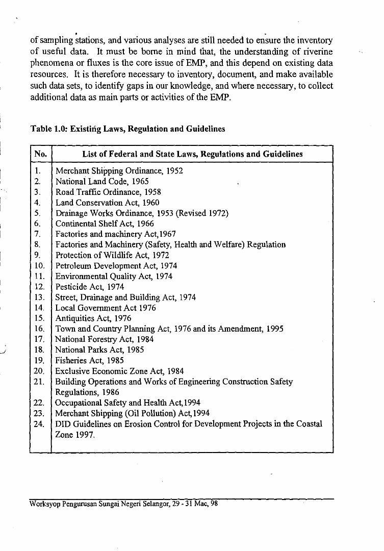
a• .
of sampling stations, and various analyses are still needed to ensure the inventoryof useful data. It must be borne in mind that, the understanding of riverinephenomena or fluxes is the core issue of EMP, and this depend on existing dataresources. It is therefore necessary to inventory, document, and make availablesuch data sets, to identify gaps in our knowledge, and where necessary, to collectadditional data as main parts or activities of the EMP.
Table 1.0: Existing Laws, Regulation and Guidelines
No. List of Federal and State Laws, Regulations and Guidelines
Merchant Shipping Ordinance, 1952National Land Code, 1965 .Road Traffic Ordinance, 1958Land Conservation Act, 1960Drainage Works Ordinance, 1953 (Revised 1972)Continental Shelf Act, 1966Factories and machinery Act,1967Factories and Machinery (Safety, Health and Welfare) RegulationProtection of Wildlife Act, 1972Petroleum Development Act, 1974Environmental Quality Act, 1974Pesticide Act, 1974Street, Drainage and Building Act, 1974Local Government Act 1976Antiquities Act, 1976Town and Country Planning Act, 1976 and its Amendment, 1995National Forestry Act, 1984National Parks Act, 1985Fisheries Act, 1985Exclusive Economic Zone Act, 1984Building Operations and Works of Engineering Construction SafetyRegulations, 1986Occupational Safety and Health Act,1994Merchant Shipping (Oil Pollution) Act,1994DID Guidelines on Erosion Control for Development Projects in the CoastalZone 1997.
Worksyop Pengurusan Sungai Negeri Selangor, 29 - 31 Mac, 98
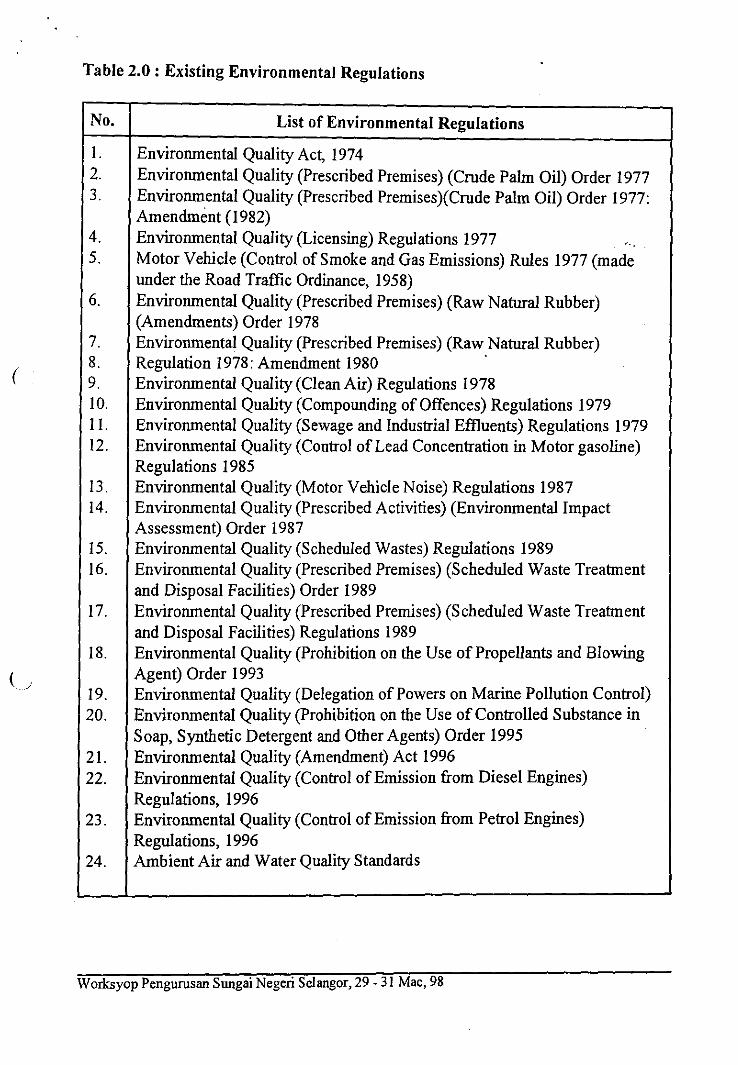
Table 2.0 : Existing Environmental Regulations
No. List of Environmental Regulations
I. Environmental Quality Act, 1974Environmental Quality (Prescribed Premises) (Crude Palm Oil) Order 1977Environmental Quality (Prescribed Premises)(Crude Palm Oil) Order 1977:Amendment (1982)Environmental Quality (Licensing) Regulations 1977 -..Motor Vehicle (Control of Smoke and Gas Emissions) Rules 1977 (madeunder the Road Traffic Ordinance, 1958)Environmental Quality (Prescribed Premises) (Raw Natural Rubber)(Amendments) Order 1978Environmental Quality (Prescribed Premises) (Raw Natural Rubber)Regulation 1978: Amendment 1980Environmental Quality (Clean Air) Regulations 1978Environmental Quality (Compounding of Offences) Regulations 1979Environmental Quality (Sewage and Industrial Effluents) Regulations 1979Environmental Quality (Control of Lead Concentration in Motor gasoline)Regulations 1985Environmental Quality (Motor Vehicle Noise) Regulations 1987Environmental Quality (Prescribed Activities) (Environmental ImpactAssessment) Order 1987Environmental Quality (Scheduled Wastes) Regulations 1989Environmental Quality (Prescribed Premises) (Scheduled Waste Treatmentand Disposal Facilities) Order 1989Environmental Quality (Prescribed Premises) (Scheduled Waste Treatmentand Disposal Facilities) Regulations 1989Environmental Quality (Prohibition on the Use of Propellants and BlowingAgent) Order 1993Environmental Quality (Delegation of Powers on Marine Pollution Control)Environmental Quality (Prohibition on the Use of Controlled Substance inSoap, Synthetic Detergent and Other Agents) Order 1995Environmental Quality (Amendment) Act 1996Environmental Quality (Control of Emission from Diesel Engines)Regulations, 1996Environmental Quality (Control of Emission from Petrol Engines)Regulations, 1996
24. Ambient Air and Water Quality Standards
Worksyop Pengurusan Sungai Negeri Selangor, 29 - 31 Mac, 98
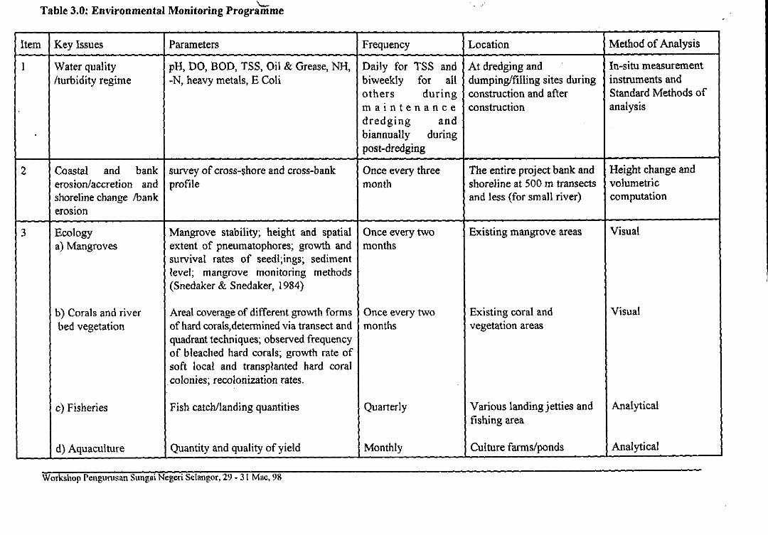
MN EMI • • • 1111113 IS MI INN SIM Mt\ MI We IMO • WO IS elTable 3.0: Environmental Monitoring Programme
Item Key Issues Parameters Frequency Location Method of Analysis
1 Water quality/turbidity regime
pH, DO, BOD, TSS, Oil & Grease, NH,-N, heavy metals, E Coli
Daily for TSS andbiweekly for allothers duringmaintenancedredging andbiannually duringpost-dredging
At dredging anddumping/filling sites duringconstruction and afterconstruction
In-situ measurementinstruments andStandard Methods ofanalysis
2 Coastal and bankerosion/accretion andshoreline change Thankerosion
survey of cross-shore and cross-bankprofile
Once every threemonth
The entire project bank andshoreline at 500 in transectsand less (for small river)
Height change andvolumetriccomputation
3 EcologyMangroves
Corals and riverbed vegetation
Fisheries
Aquaculture
Mangrove stability; height and spatialextent of pneumatophores; growth andsurvival rates of seedlings; sedimentlevel; mangrove monitoring methods(Snedaker & Snedaker, 1984)
Areal coverage of different growth formsof hard corals,determined via transect andquadrant techniques; observed frequencyof bleached hard corals; growth rate ofsoft local and transplanted hard coralcolonies; recolonization rates.
Fish catch/landing quantities
Quantity and quality of yield
Once every twomonths
Once every twomonths
Quarterly
Monthly
Existing mangrove areas
Existing coral andvegetation areas
Various landing jetties andfishing area
Culture farms/ponds
Visual
Visual
Analytical
Analytical
Workshop Pengunisan Sungai Negeri Selangor, 29 - 31 Mac, 98
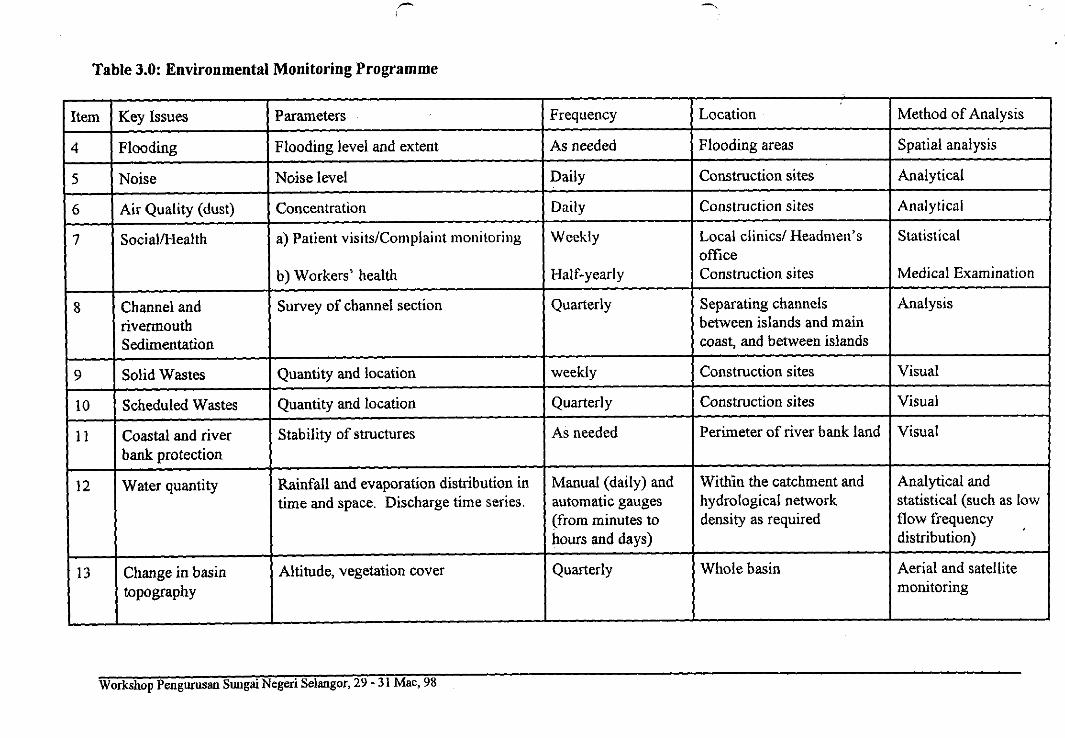
Table 3.0: Environmental Monitoring Programme
Item Key Issues Parameters Frequency Location Method of Analysis
4 Flooding Flooding level and extent As needed Flooding areas Spatial analysis
5 Noise Noise level Daily Construction sites Analytical
6 Air Quality (dust) Concentration Daily Construction sites Analytical
7 Social/Health Patient visits/Complaint monitoring
Workers' health
Weekly
Half-yearly
Local clinics/ Headmen'sofficeConstruction sites
Statistical
Medical Examination
8 Channel andrivermouthSedimentation
Survey of channel section Quarterly Separating channelsbetween islands and maincoast, and between islands
Analysis
9 Solid Wastes Quantity and location weekly Construction sites Visual
10 Scheduled Wastes Quantity and location Quarterly Construction sites Visual
11 Coastal and riverbank protection
Stability of structures As needed Perimeter of river bank land Visual
12 Water quantity Rainfall and evaporation distribution intime and space. Discharge time series.
Manual (daily) andautomatic gauges(from minutes tohours and days)
Within the catchment andhydrological networkdensity as required
Analytical andstatistical (such as lowflow frequencydistribution)
13 Change in basintopography
Altitude, vegetation cover Quarterly Whole basin Aerial and satellitemonitoring
Workshop Pengurusan Sungaz Negeri Selangor, 29 - 31 Mac, 98
MI MN 0 0 a 10I a a MS MEM MS SI a OS •
There are, then, several necessary upgrades required of the basic monitoringsystem and methodology for flow and river borne fluxes (sediments, pollutants,etc) at the river/drainage basin scale. In this context, it is proposed that a map ofexisting data sets, their associated river/drainage basin attributes, periods of record,rates of urbanisation and industrial growth shall first set up to provide valuablebaseline data upon which to establish informed proposals for the upgrading ofenvironmental monitoring networks.
The second issue is on modelling activities. The main goal of modelling exercisesis to achieve an optimum understanding of various physical flow phenomena in thecontext of the rates, timing, and controls on riverine transport of sediment, organicmatters and other particulates, flooding behaviour, flow reaction to domain change(e.g due to development) and water body eutrophication over space and timeThus, modelling capability is a prerequisite for EMP in order to enable assessingchanges in the dynamic properties of river systems in the context of localized andglobal change within the basin. Modelling exercises all seek to achieve aneventual integration of drainage catchment or basin models with coastalhydrodynamic models, hydrologic on-line predictive models and biological models.The capability in this context is currently limited and therefore the desired linkagesare not available yet. Currently, the existing model generally used to evaluate thepotential changes to the river hydrodynamic and sedimentary developments withinthe modelling domain (i.e basin). This stage normally involves the comparison ofwith and without-project scenarios based on the location and planform geometryof the river reaches and basin. The physical impacts predicted from the modellingworks are then interfaced with the socio-economic, fisheries, and ecologicalspecialists, among others in order to translate the physical impacts into biologicaland physiological impacts expected to be sustained by drainage/river basincommunity and ecosystems. Down the line of the assessment chain, empiricalrelationships and qualitative interpretations are still relied upon.
5.2 The Challenges and Recommendations
Natural processes and socio-economic responses within the drainage/river basinchange very rapidly in this country over short time frame. Within this region,ecosystems often show differential, highly non-linear responses to changes inenvironmental parameters Many ecological and hydrological studies within thebasin to date focused on single sites or single, small catchments, respectively.Hence, the extrapolation of information/data gathered from existing site-orientateddata gathering exercises often is not appropriate. Therefore, it is an urgent need tostudy and monitor hydrological and ecological processes and their interaction with
Worksyop Pengurusan.Sungai Negeri Selangor, 29 - 31 Mac, 98
I
I11
1
11111
* Organise follow-up meetings or workshops to better articulate theissue of feedbacks on human settlement brought about by changes inthe drainage/river hydrological and ecological systems.
e) Establish Supporting Grant for Drainage/River basin EMP
EMP could not be effectively implemented unless a sound scientificapproach is adopted with a multidisciplinary research and inter-agencyparticipation. This can only be achieved with the continuos financialsupport from the government (state and federal level), grant from researchcouncil (e.g IRPA under MOSTE), private water companies, andinternational research funding bodies like International HydrologicalProgram (IHP). The viability and sustainability of such EMP will heavilydependent on the implementing agency to avail funds and sponsors. In thiscontext, one-stop R&D agency such as NAHRIM, shall be trusted with aresponsibility to raise, manage and utilize such fund in a more transparentand legitimate manner since it is a government owned R&D institute.NAHRIM shall then will gradually build up its capacity (manpower,infrastructures) in order to convince prospective sponsors (private andgovernment) to pool their resources and have trust in NAHRIM to carry outR&D needs of the EMP as well as the real coordination of theimplementation of cooperative and collaborative activities of any EMP.
6.0 CONCLUSIONS
The previous Third, Fifth and Sixth Malaysia Plans (MP) have advocated the needto strike a balance between physical development and the protection of theenvironment. Under the 7MP the word "sustainable development" is mentionedeventhough it is not explicitly defined. Nonetheless, we know that it simply meansthe encouragement of developments but at the same time safeguarding the needsof our future generations for the existing unspoiled or at least safe, acceptableconditions of the environment of our for example, drainage/river basin and itsnatural resources (e.g drinking water). These development activities will definitelycatalyze the destruction of these resources, if left unchecked and unguided. Nodoubt, increasing case of multiple-use conflicts have surfaced with rapiddevelopments; industrial and commercial activities versus recreation and tourism;fisheries versus riverfront and nearshore developments, waste disposals andcatchment area development against water supply sufficiency and quality. Thismeans to imply that the past and current activities taking place within the riverbasin in the country are not always compatible. This is because the renewable river
Worksyop Pengurusan Sungai Negeri Selangor, 29 - 31 Mac, 98
not implementing EMP now may therefore not be felt tomorrow, but when theseconsequences do occur (e.g water shortages in Klang Valley) they could be seriousand very difficult and complex, costly to address.
Considering the recent developments on the country's state of natural resources(e.g water) and its implication on socio-economic systems especially in KlangValley, it can be concluded that the drainage/river basin hydrological andecological processes are at risk and need special attention, in particular our lowresponse capability to crisis. Intensified, collaborative and coordinated research,built-in to an EMP, is required, which can be fostered best through a state andnational level program The eventual goal is the EMP will produce a spatial andtemporal account of any development and its impacts within the drainage basindomain covering both research needs and policy-related issues which need to beconsolidated in line with the overall basin management objectives. The former ismore stressed so that more important baseline data can be gathered and databankcan be improved and enlarged. Besides providing information on criticalhydrological and ecological processes and its responses to human activities, suchdata are crucial for verification and improvement of many existing predictivemodels. With better predictive capability policies, laws, and guidelines can bebetter legislated to address critical issues such as the future capacity of the riverinesystem to provide sufficient, clean supply of water, habitat, food chains, publichealth, trans-boundary transportation, and protection of water. This poses dramaticnew challenges to hydraulic engineering and to Malaysia as a whole.
7.0 REFERENCES
NAHRIM et alia (1997) "Macro Environmental Impact Assessmentfor Kedah Coastal Reclamation - Final Report, October.
Ibrahim, A.A (1998) "Water Engineering in Beyond Year 2000Malaysia - Issues, Researches and Policy and TechnologicalDevelopment" Keynote Paper delivered at 10th Congress Asia pacificDivision - IAHR, August, Langkawi.
UNESCO (1997) "Local Scale Hydrological Processes in Islands,Highlands and Urban Areas in Malaysia - Needs for Future Direction"Workshop Report, November, Kuala Lumpur.
Ibrahim, A.A (1996)"Malaysia's Coastal Zone Development andRelated Issues" Cabinet Paper submitted to Hons. Minister, Ministryof Agriculture, Malaysia.
I tmonitarl 2398
Worksyop Pengurusan Sungai Negeri Selangor, 29 - 31 Mac, 98
resources (e.g water, fisheries, etc) are directly dependent on the maintenance ofthe pristine state of the existing surrounding environment. It is no doubt that wateris a key element of nature and life and the uses of river interfere directly with thenatural systems. Hydraulic structures and water supply schemes constructed in theeffort to protect human settlement and match the water needs of society with theavailability of water available in its natural form necessarily cause conflicts, andimply changes in space and time distribution and also in water quality.
Arising from the above concerns therefore, there is an urgent need to find formulafor sound management of the increasing riverfront/basin development projects andresources harvestings (for water supply for example). One such formula is theEnvironmental Monitoring Program (EMP), a truly multi sectoral programincorporating a non-policy matter inputs (analyses, modelling, data gathering,capacity building, and R&D efforts) from all relevant sectors. EMP can beconsidered as a follow-up or preventive action plan to ensure that the future secondgeneration policies and acts produce better results. As it name implies EMP is amonitoring program with increasing focus on R&D hi most EMP implementationframework R&D works becoming common and gradually form a powerful tool tosupport the work of various relevant agencies since many good ideas for solutioncan be obtained through committed R&D activities.
However, since R&D is relatively new in Malaysia and requires skillful, highlycompetence manpower, heavy equipments and capital investment, and conduciveenvironment, it is therefore wise at this stage of EMP implementation in thiscountry, to focus immediately on researches that are critical to planning andmanagement of water resources and understanding better the impacts of inducedchanges due to human activities within the river basin on hydrological andecological processes. Concentration of these efforts in a collective manner orwithin a dedicated organisation like NAHUM is strongly recommended.
Impacts could not be effectively assessed unless an integrated, continuous andsound scientific approach is adopted together with a multidisciplinary,collaborative research. This definitely will eventually prevent duplication of rolesand investment, and the available fund can hence be optimally utilised. And theimplementation of the EMP must be earnestly enforced now even with our currentshallow understanding in responding to potential changes in the basin ecosystems.The typical Malaysian way of "take action later" or "take action only when crisisoccur" when confronted with crisis shall not apply to water-related problem. Thisis because the natural processes involved in any water crisis have a lag times ofseveral years on even decades, e.g the El Nino phenomena. The consequences of
Worksyop Pengurusan Sungai Negeri Selangor, 29 - 31 Mac, 98
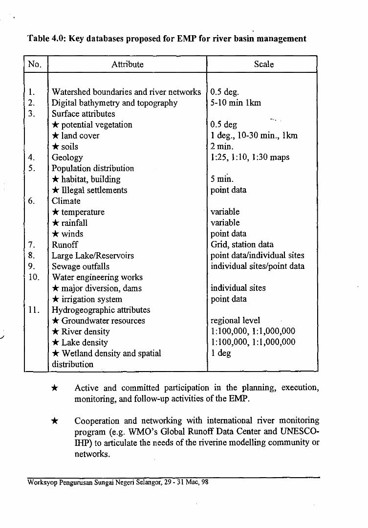
Table 4.0: Key databases proposed for EMP for river basin management
No. Attribute Scale
Watershed boundaries and river networks 0.5 deg.Digital bathymetry and topography 5-10 min llcm
3. Surface attributes* potential vegetation 0.5 deg* land cover 1 deg., 10-30 min., llun* soils 2 min.
4. Geology 1:25, 1:10, 1:30 mapsPopulation distribution* habitat, building
.-5 min.
* Illegal settlements point dataClimate* temperature variable* rainfall variable* winds point dataRunoff Grid, station dataLarge Lake/Reservoirs point data/individual sitesSewage outfalls individual sites/point dataWater engineering works* major diversion, dams individual sites* irrigation system point data
11. Hydrogeographic attributes* Groundwater resources regional level* River density 1:100,000, 1:1,000,000* Lake density 1:100,000, 1:1,000,000* Wetland density and spatialdistribution
1 deg
* Active and committed participation in the planning, execution,monitoring, and follow-up activities of the EMP.
* Cooperation and networking with international river monitoringprogram (e g. WMO's Global Runoff Data Center and UNESCO-IHP) to articulate the needs of the riverine modelling community ornetworks.
Worksyop Pengurusan Sungai Negeri Selangor, 29 - 31 Mac, 98
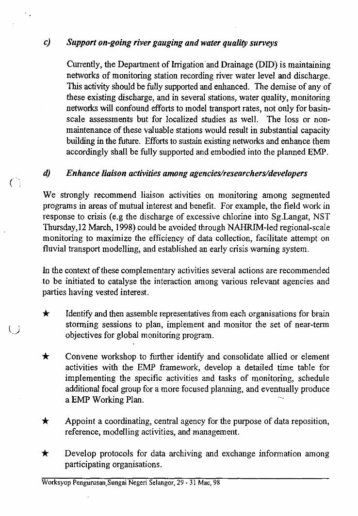
c) Support on-going river gauging and water quality surveys
Currently, the Department of Irrigation and Drainage (DID) is maintainingnetworks of monitoring station recording river water level and dischargeThis activity should be fully supported and enhanced. The demise of any ofthese existing discharge, and in several stations, water quality, monitoringnetworks will confound efforts to model transport rates, not only for basin-scale assessments but for localized studies as well. The loss or non-maintenance of these valuable stations would result in substantial capacitybuilding in the future Efforts to sustain existing networks and enhance themaccordingly shall be fully supported and embodied into the planned EMP.
d) Enhance liaison activities among agencies/researchers/developers
We strongly recommend liaison activities on monitoring among segmentedprograms in areas of mutual interest and benefit. For example, the field work inresponse to crisis (e.g the discharge of excessive chlorine into Sg.Langat, NSTThursday,12 March, 1998) could be avoided through NAHRIM-led regional-scalemonitoring to maximize the efficiency of data collection, facilitate attempt onfluvial transport modelling, and established an early crisis warning system.
In the context of these complementary activities several actions are recommendedto be initiated to catalyse the interaction among various relevant agencies andparties having vested interest.
Identify and then assemble representatives from each organisations for brainstorming sessions to plan, implement and monitor the set of near-termobjectives for global monitoring program.
Convene workshop to further identify and consolidate allied or elementactivities with the EMP framework, develop a detailed time table forimplementing the specific activities and tasks of monitoring, scheduleadditional focal group for a more focused planning, and eventually producea EMP Working Plan.
Appoint a coordinating, central agency for the purpose of data reposition,reference, modelling activities, and management.
Develop protocols for data archiving and exchange information amongparticipating organisations.
Worksyop Pengurusan Sungai Negeri Selangor, 29 - 31 Mac, 98
models to describe and test hypotheses about the above processes strictlyunder Malaysian climates and boundary conditions.
The above three challenges have been identified and considered prerequisites forsetting up a comprehensive environmental monitoring program for river within theframework of this activity aimed at detecting the hydrological and ecologicalimpacts on water resources within a particular drainage/river basin. It is nowrecommended that the following specific activities to be carried out, built-in intothe EMP framework, to help achieve/overcome those challenges.
Develop or upgrade an integrated hydrological and ecological database
A standardized, geographically-referenced database on hydrological andecological aspects and its supporting software tools should be developed (orthe existing one improved and upgraded) and made easily retrievable andavailable to the research and interested parties. An archiving of suchcomputerized database of information derived from several sources, shouldbe maintained at a central repository such as NAHRIM. The database shallmaintain a regional coverage but holding more highly resolved sectoral andcase study data sets. The database ideally should contain data sets listed inTable 4.0 below. A GIS system of data inventoring permitting easy onlineacquisition and manipulation of data sets should be developed and used.Once this data system is available,more efforts should be channelled towardsthe checking of existing data for formatting consistency and accuracy.Addition of new data sets would be a natural outgrowth of the EMP activity.
Promote aggressive EMP initiative
Since relatively few coherent data sets are available for meaningfulassessment of several water-related issues/phenomena, it is stronglyrecommended that EMP to be implemented for all development projectswithin drainage/river basin with emphasis on enhancement to databasegathering and built-up efforts. Monitoring of areas within the basin whichundergo rapid development will be particularly important in Malaysia overthe coming years. Close collaboration between all agencies and partiesinvolve in the development should be made mandatory to ensure that theemerging data set (as a result of the implementation of EMP) are ofrelevance to monitoring agency and policy maker. Extension of the EMPto major upstream tributaries will ensure additional inventories of data setswhich will be very handy in extensive basin model development.
Worksyop Pengurusan Sungai Negeri Selangor, 29 - 31 Mac, 98
various development attributes along the drainage/river courses, with a particularemphasis on the influence of change in land surface characteristics. In particular,the foregoing discussion amply demonstrates the need, in this context, for asystematic collection and interpretation of data sets relevant to quantifying waterand material flux from the basin's drainage systems, built-in into the EMP.Specifically in this context, we are facing a three-fold challenges:-
the conduct of monitoring and limited field experiments to study in-situ thevarious ecological and hydrological phenomena taking place within the EMPdomain/boundary. This exercise will provide answers to questions such as:how does ecosystems change with development; does the ecosystemsattributes (e.g water quality) decrease as development increases? How doesthis affect its function as a source of drinking water? What is the effect ofadding or removing certain functional vegetation on erodibility of the riverbank? This experiment ( and it can be in real form of development activitiese.g river training and impoundment work) on ecological and hydrologicalmanipulations need to be followed up by an extensive monitoring programof the affected hydrological parameters and variables to understand theinteractions and facilitate the extrapolation of the results.
Linking the gained knowledges from activity 1, towards a more integratedimpact assessment to larger spatial scales, specifically basin or catchmentscale. Traditionally, bio-scientists tend to focus on site-specific studiesneglecting any spatial aspects, e.g lateral fluxes of water and sediments.Similarly, engineers tend to neglect vegetative cover diversity in theirhydrological studies - vegetation properties are often assumed uniform andstatic when differentiated across the basin area. Hence, to achieve athorough understanding the impacts of ecosystem and land use changes onhydrological (i.e water resources) and ecological processes within the basinarea, the knowledge from both disciplines must be coupled, e.g., throughmodelling. This crucial understanding will go a long way towardsanswering pertinent questions like: how change in environmentalcharacteristics and land use (due to development) along the river reaches, inheadwater catchments and at the basin scale affect and/or controlhydrological processes (e.g. evapotranspiration, infiltration and runoff, andeventually the supply of water), vegetative structure and other characteristicssuch as river bank erosion and slope stability.
3) The understanding of relevant mathematical models (existing) and thecultivation of indigenous technological capability in developing in-house
Worksyop Pengurusan Sungai Negeri Selangor, 29 - 31 Mac, 98
The Development of Sabah Water Resources Enactment
Ir. Mg Chee Hing, *BE(NSW).MIEM,PEag,MIE(Aust),CPEng,MCIWENI,MICE,CEng.
ABSTRACT
The development of a Sabah Water Resources Enactment (SWRE) is proposed in theSabah Water Resources Master Plan 1994 which is a strategic study of therequirements for the sustainable development and management of water resources inSabah. This legislation will introduce powers to investigate, determine, monitor and topolice activities which have not )een covered under existing legislation such as TheSabah Land Ordinance (Cap.68) and The Sabah Forest Enactment (1968) which arenot explicitly suitable for protection of the State water resources.
1. INTRODUCTION
1.1. In 1982, the Govern;nent of Malaysia engaged Japan InternationalCooperation Agency (JCA) to carry out 'THE NATIONAL WATERRESOURCES STUDY,, MALAYSIA' which covered the whole nationincluding the State of Sabah. In 1992, the State Government of Sabah uponthe advise of the Depirtment of Irrigation and Drainage (DID) Sabah,recognized the need to follow up with the JICA study (1982) to specificallydeal with the sustainable development and management of the State waterresources. The Sabah Water Resources Master Plan study was initiated in1992 and was completed in 1994, whereby various strategies to achieve theobjectives of sustainable development and management of the State waterresources had been proposed. The Master Plan was accepted by the StateGovernment in 1995 and DID Sabah was entrusted with the responsibility ofimplementing the plan. To provide the legal basis for managing the Statewater resources, the follpwing recommendations as contained in the MasterPlan have to be implemented :
Establishment of a Water Resources Manager.
Development of a Water Resources Enactment
iii) Development of Catchment Management Plans.
1.2. This paper will present and discuss the process and the purpose of thedevelopment of the Sabah Water Resources Enactment as well as someprincipal aspects of the ptoposed bill.
* Chief Engineer, Drainage & Irrigation Section, Department of Irrigation & Drainage., Sabah
.7.
2. DEVELOPMENT APPROACH
2.1. The Sabah Water Resources Enactment (SWRE) aims to provide a new legalinstrument to the State; of Sabah to enable it to protect its water resourcesbased on the objectives ptrd recommendations identified in the Master Plan.Two other major natural resources of the State namely the Land and Forestare legislated and regulated under The Sabah Land Ordinance (Cap.68) andThe Sabah Forest Enacrent (1968) respectively. The approach to developthe SWRE has to 'provide flexibility and adequate coordination of activitieswithin Sabah such as and use, timber logging, and protection of bio-diversity which have significant bearings on the water resources in the State.
2.2. The development of the SWRE involves the followings:
The Initial Consultation.
Sixteen (16) State and Federal agencies were initially consulted to obtaintheir views relating to constraints and issues relevant to water resourcesmanagement in Sabahf
Project Steering Committeer
A Steering Committee chaired by the State Attorney-General andconsisting of 17 heads of department/agencies having a stake in waterresources was set uj, E, to provide strategic direction and guidance to theConsultant as to Cite appropriate powers and mechanisms for theEnactment and also tb ensure that the Enactment will be in consonancewith other legislation.'
Workshop
A 2-day workshop Was held to deliberate in depth the issues identifiedduring the initial consultation. This workshop was attended by topofficials from the releivant state and federal departments/agencies. A totalof 59 participants attended the workshop in which 17 issues werediscussed
Project Working Group
Two Senior Legal Officers from the State Attorney-General's Chamberand a few senior offic rtrs from the relevant departments and the Consultantteam form a working group to embark on the preliminary drafting of theEnactment. Views and requirements of other departments/agenciesobtained during the consultation and through the workshop are carefullyaddressed.
n
2
• • •
-3-
Final Consultation
A final visit was made to all relevant departments/agencies to consult anddiscuss the draft Enactment to gain agreement of all parties related towater resources management.
Review of Draft Bill
The completed draft Bill was to be reviewed by the State Attorney'sChamber and translated into Bahasa Malaysia.
The Enactment
The State Legislature will enact the law in due course.
3. OBJECTIVES OF THE ENACTMENT
3.1. The purpose of theWater Resources Enactment is to provide for thecontinuing sustainability f water resources and the optimization of beneficialuses of water and water 'resources values to the community and the State ofSabah. The legislation would provide for the following objectives:
To enable the State Govemment of Sabah to manage the State waterresources in a sustainable manner.
To define the water resources of Sabah and confirm the StateGovernment's control and ownership of these (including wetlands andgroundwater)
To establish a Director of Water Resources with responsibility formanaging water resources in harmony with the land use and forest.
To introduce a licensing system for all water activities in water bodies.
To establish a State Water Resources Council to advise the StateGovernment on wader resources management and to form IntegratedCatchment Committed at the District level for the same purpose.
To require the State Government to prepare Catchment Management Plansfor rivers in the State..
3
-4-
4. PRINCIPAL ASPECTS OF THE PROPOSED BILL
4.1. Director of Water Resources
One major provision of the Enactment is the establishment of a Director ofWater Resources in the State. The functions of the Director shall be to:-
Manage the State's miter resources
Take action to protect the quantity and quality of water resources and theaquatic environment
Develop, implement and monitor catchment management plans includingfloodplain management plans, surface water management plans, andgroundwater manageritent plans.
Plan for the orderly ;development and use of water resources and takemeasures to resolve conflict between water uses.
It is expected that the Department of Irrigation and Drainage (DID), Sabah,which has been entrusted with the task of implementing the Water ResourcesMaster Plan will continue; to assume the roles of the Water Resources Managerafter the law is enacted. •A. Water Resources Management Unit (WRMU) hasbeen established within DID and this will form the basis for the administrativework for the Director of Water Resources. A full fledge Department of WaterResources would be formed when the capacity building for the requiredexpertise is achieved to assume fully the functions of a Water ResourceManager, ideally to be placed under the same administrative control of theLand and Forest resources.
4.2. The State Water Resources Council
The Enactment stipulates :the formation of a State Water Resources Councilwith the following functions:
Advise the Minister responsible for water resources on the managementand use of water resources;
Report to the Minister on the conditions of water resources;
Make recommendations on the improvement of quantity and quality ofwater for benefits of . human use, the flora and fauna and the aquaticenvironment such as wetlands and floodplains;
Determine those water activity license applications which have State orregional significance of are of particular significance in a local area;
4
- 5 -
Adopt and review plans for the orderly and effective development of waterresources;
Set priorities for, ensure the development of, recommend for approval andreview catchment management plant and other plans for the improvementof the management of water resources;
Develop and issue, with the approval of the Minister, State policies andguidelines for the management and protection of water resources;
Require public authorities to:
to take action to , implement the recommendations of an approvedcatchment management plan including taking enforcement action whererevelant and
act to minimize or prevent harm to water resources.
4.3. Catchment Planning and Protection
4.3.1. Another important provision of the Enactment is the formulation andgazetting of Integrated Catchment Management Plans for intendedriver catchments.
4.3.2. The concept of Integrated Catchment Management (ICM) is introducedin the Sabah Water Resources Master Plan as the key to implement theMaster Plan on the ground. ICM is to provide a system of controls toprotect the quality and quantity of water resources from various humanactivities which pollute or degrade these resources. Under the proposedlegislation, the Water Resources Council may establish a CatchmentManagement Committee (an ICM Committee) comprising ofrepresentatives of the various interests in the catchment and this willprovide input on identifying relevant issues, and on devising andimplementing of management options in preparation of ICM plans.
4.3.3. Each ICM plan with recommendations on controls and managementactions would be endorsed by the Water Resources Council before it issubmitted to the Head of State for approval. Once approved andgazetted, any recommended control or action in the Plan wouldbecome binding on all relevant administrative agencies.
4.3.4. The Water Resources Council would monitor progress of Planimplementation and could require any agency to provide feedback onsteps or actions taken to accomplish the objectives of the Plan.
5
-6-
4.4. Licensing System
4.4.1. The proposed bill also provides for a licensing system for variouswater activities. The following four main categories of activity willrequire a license :
The use of water and the construction and use of works for thatpurpose. The works would include dams, diversion works, pumps,canals, and also include wells and bores for ground water use.
Artificial or constructed works which cause water to return to awater body, such as drains and canals.
Those works which impede or affect the flow of flood waters.
Activities which alter the bed, banks or foreshore of a water body(mainly rivers) such as excavations, but including the depositing ofmaterials also.
4.4.2. It will become an offence to undertake any of these activities withouta license.
4.4.3. Minor water users for domestic purpose such as gravity feed watersupply system and small scale agriculture would be exempted from theneed to be licensed. However, the Director could require such uses tobe registered (i.e. obtain information about where they are situated andthe scale of use) if he is satisfied that there are likely impacts on thewater resources.
4.4.4. Public authorities can be exempted from the requirement of a licenseby the Minister responsible for the water resources. However, thewater activities must be specified in the Gazette.
4.4.5. Pre-existing water use works would be recognized by issue of alicense. However conditions may be imposed on these licenses whichrequire the license holder to recognize the rights of others and theeffect of water use on water resources.
4.5. Riverine Reserve
4.5.1. One other aspect covered by the proposed bill is the provision ofriverine reserve, which has been recognized as important for waterquality protection.
6
111
11
1
1
1
17-UJ-1,70 rrturi rrCUVI Jrt bH13HH MHLHT1H
- 7 -
4.5.2. The proposed bill specifies a minimum of 20 metre wide riverinereserve on each bank of a waterway of 3 metre width or more. TheDirector of Water Resources is enpowered to control activities withinthis reserve which cause pollution or degradation of water. Provisionto increase or decrease river reserves in other deserving situations isalso available.
ENACTMENT OF THEBILL
Over a 2 year period, the drafting of the Sabah Water Resources bill has finallybeen completed and is expected to be enacted in 1998.
CONCLUSION
6.1. After the tragic occurrence of "Greg" in December 1996 which caused heavycasualties with the loss of hundreds of human lives and immense damages toproperties, the current 'El Nino' and the impending 'La Nina' effects, the needto better manage water resources and river basins has gained the recognitionthat it rightfully deserves, from the authorities concerned.
6.2. The Sabah Water Resources Enactment will provide the State Government aneffective means of controlling, maintaining and developing the State waterresources in a sustainable manner. The State will thus be able to betterprepare itself to face future challenges of increasing pressure on its waterresources posed by rapid population growth, urbanization, industrial andagricultural development, and land use changes which are affecting waterquantity and quality, as well as extreme weather cycles which all have to face.
6.3. It is hoped that initiatives taken by the State of Sabah along this directioncould stimulate useful inspiration for our sister States in this county to workout plans and strategies in handling similar, if not more complex waterresources issues.
REFERENCES
"Water Resources Master Plan — Negeri Sabah 1994" Volume 1 & 2
"A Strategic Approach to The Management of Water Resources With ReferenceTo The State of Sabah, Malaysia." (Dugald Black & Paul Taylor, Department of Land andWater Conservation, New South Wales, Australia).
3. Sabah Water Resources Enactment (Draft)
7
•
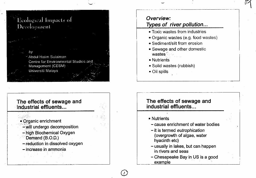
Ecolo-1^1; 11 In hais of
De celwititetil
by
- Abdul Halm SuiaimanCentre for Environmental Studies andManagement (CESM)Universiti Malaya
The effects of sewage andindustrial effluents...
n Organic enrichmentwill undergo decomposition
. .- high Biochemical Oxygen
Dernand (B.O.D.)- reduction in dissolved oxygen- increase in ammonia
OM I= MN IrkNM UM !WM a — — — - IMIN
Overview:Types of river pollution...
Toxic wastes from industriesOrganic wastes (e.g. food wastes)Sediment/silt from erosionSewage and other domesticwastes'NutrientsSolid wastes (rubbish)Oil spills
The effects of sewage andindustrial effluents...
•
Nutrients- cause enrichment of water bodies
it is termed eutrophication(overgrowth of algae, waterhyacinth etc)usually in lakes, but can happenin rivers and seasChesapeake Bay in US is a goodexam le
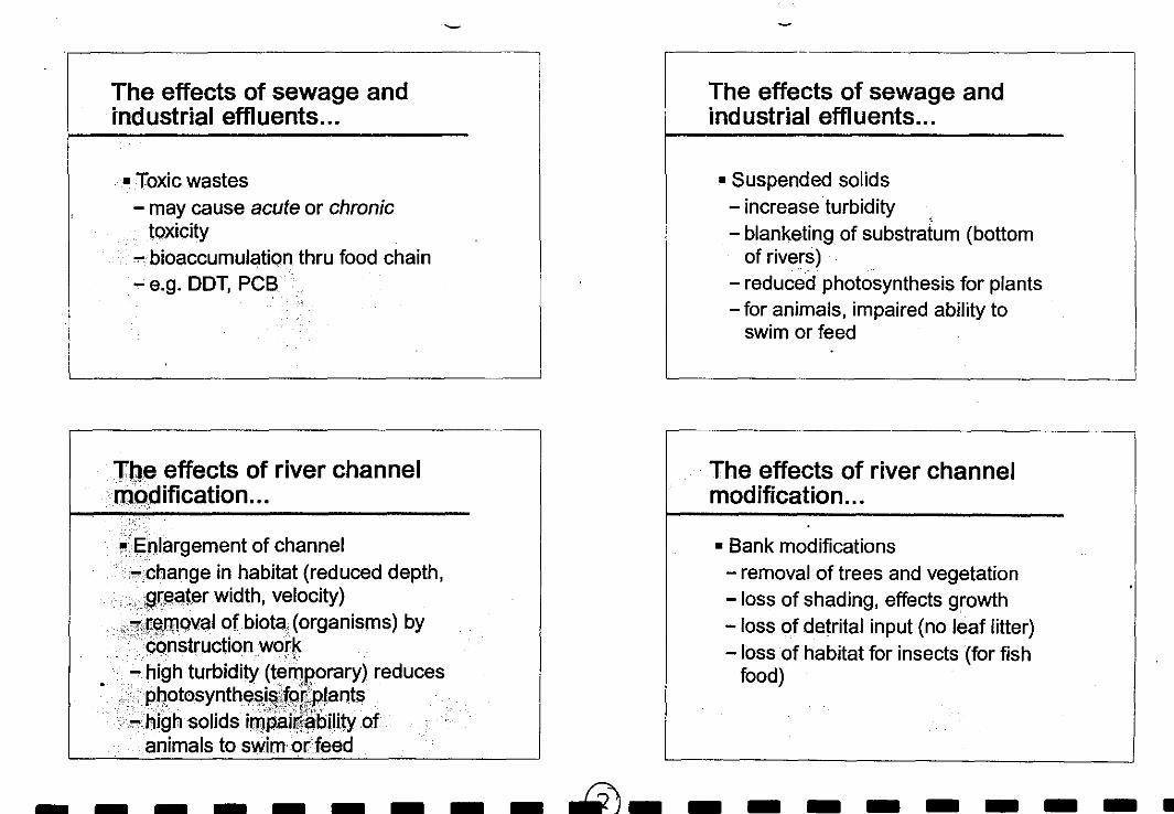
The effects of river channelmodification...
Enlargement of channel- change in habitat (reduced depth,
greater width, velocity)- removal of biota (organisms) by
construction work- high turbidity (temporary) reduces
photosynthesis,lorplantshigh solids irupair&bility ofanimals to swim or feed
The effects of sewage andindustrial effluents...
n Toxic wastes- may cause acute or chronic
toxicitybioaccumulation thru food chain
- e.g. DDT, PCB
The effects of sewage andindustrial effluents...
n Suspended solids- increase turbidity- blanketing of substratum (bottom
of rivers)reduced photosynthesis for plantsfor animals, impaired ability toswim or feed
The effects of river channelmodification...
•
n Bank modifications- removal of trees and vegetation- loss of shading, effects growth- loss of detrital input (no leaf litter)- loss of habitat for insects (for fish
food)
MIN MN Ern a • NM IM NMI s a NM 0 me
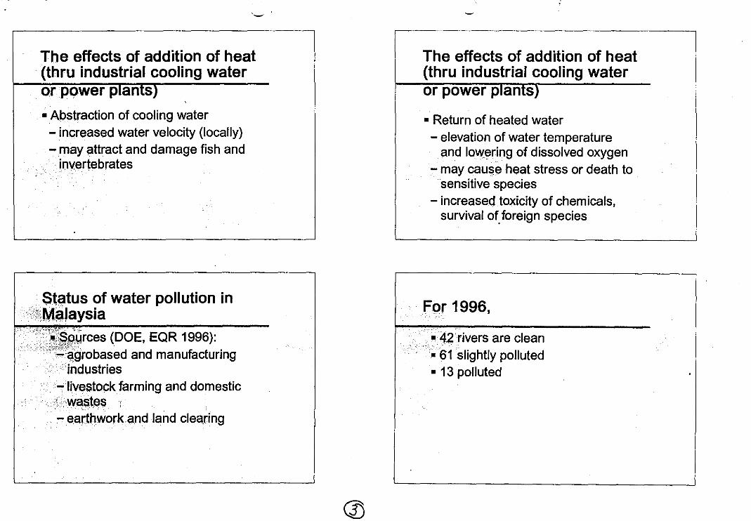
Status of water pollution inMalaysia
urces (DOE, EQR 1996):agrobased and manufacturingindustrieslivestock farming and domesticwastes
- earthwork and land clearing
mommunionms
The effects of addition of heat(thru industrial cooling wateror power plants)
n Abstraction of cooling water- increased water velocity (locally)- may attract and damage fish and
invertebrates
The effects of addition of heat(thru industrial cooling wateror power plants)
n Return of heated water- elevation of water temperature
and lowering of dissolved oxygen- may cause heat stress or death to
sensitive species- increased toxicity of chemicals,
survival of foreign species
For 1996,
n 42 rivers are clean61 slightly polluted13 polluted
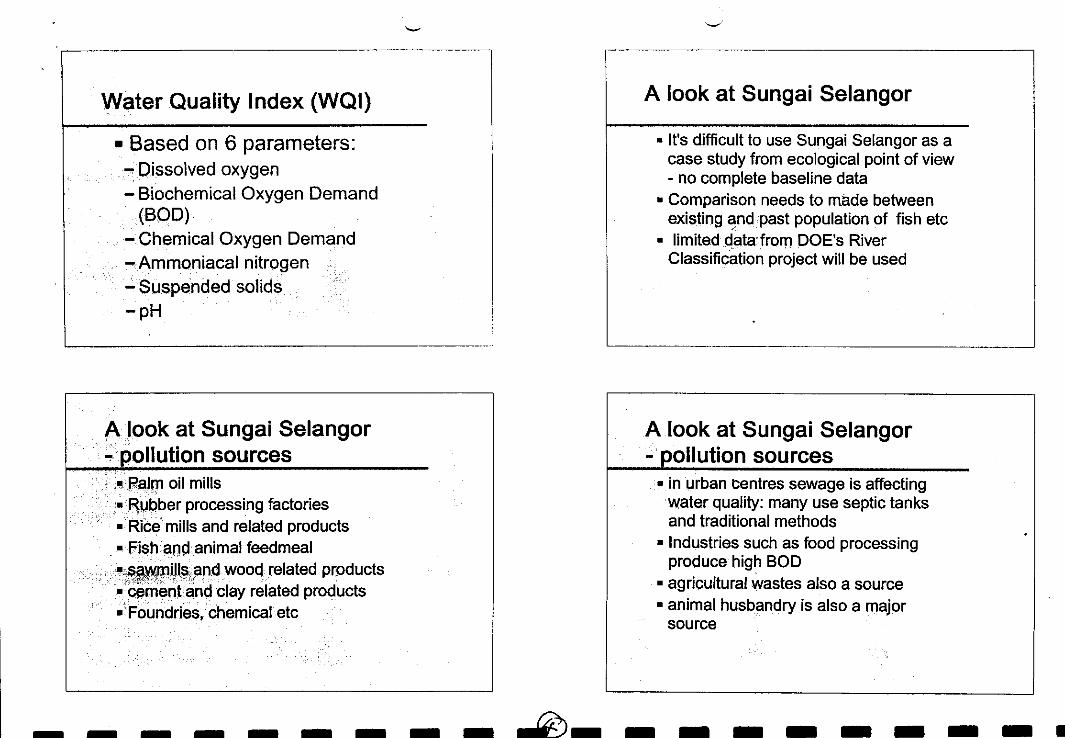
Water Quality Index (WQI)
Based on 6 parameters:Dissolved oxygenBiochemical Oxygen Demand(BOD)Chemical Oxygen DemandAnnmoniacal nitrogenSuspended solids
— pH
A look at Sungai Selangor
It's difficult to use Sungai Selangor as acase study from ecological point of view- no complete baseline dataComparison needs to made betweenexisting and past population of fish etclimited data from DOE's River
Classification project will be used
A look at Sungai Selangorpollution sources
Pekin oil millsRubber processing factoriesRice mills and related productsFish and animal feedmeal
Milts and wood related productscement and clay related productsFoundries, chemical etc
A look at Sungai Selangor- pollution sources
in urban centres sewage is affectingwater quality: many use septic tanksand traditional methodsIndustries such as food processingproduce high BODagricultural wastes also a sourceanimal husbandry is also a majorsource
a a a a a a a • MIN MN • MI MTh
A look at Sungai Selangor- water • ualit
major part (B. Berjuntai upstream) is ofClass IIIonly two segments are Class II andClass I
A look at Sungai Selangorquatic-ecology
the DOE River Classification alsoattempted to classify based on aquaticecologyDiversity Index of phytoplankton wasusedthere are similarities compared toclassification based on WQI, wheremost portion under Class Ill
•
MI MN IM MB 10 a a =WI IS MIN a III
Management of rivers/waterrocourcoc
important to have a proper andintegrated management of ourriverswe should integrate physical andchemical approach with that ofecologicalengineers, geologists, hydrologists,limnologists should work together
Management of rivers/waterresources
river is just like any other ecosystemcomplex but always in balanceif one component is disturbed, thewhole river ecosystem is affectedengineering vs ecological approach
That's all...
Terima kasih
Management of rivers/waterresources
we should consider havingsomething like National RiversAuthority (NRA) in the UK wherepeople from varied backgroundscontributein US there is the USGS, whichhas National WQ AssessmentProgram (integrated andmulti-displinary)
oil MI MI MI MS OM IS 0 MO NM In IS MO ON NM
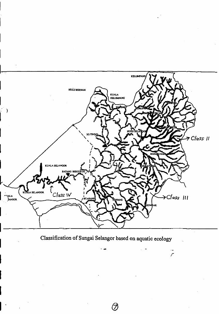
Classification of Sungai Selangor based on aquatic ecology
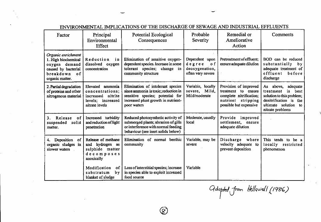
ENVIRONMENTAL IMPLICATIONS OF THE DISCHARGE OF SEWAGE AND INDUSTRIAL EFFLUENTS
Factor PrincipalEnvironmental
Effect
Potential EcologicalConsequences
ProbableSeverity
Remedial orAmeliorative
Action
Comments
Organic enrichmentHigh biochemical Reduction i n Elimination of sensitive oxygen- Dependent upon Pretreatment of effluent; BOD can be reduced
oxygen demand dissolved oxygen dependent species. Increase in some degree o f ensure adequate dilution substantially bycaused by bacterialbreakdown oforganic matter.
concentration tolerant species; change incommunity structure
deoxygenation,often very severe
adequate treatment ofeffluent beforedischarge
Partial degradation Elevated ammonia Elimination of intolerant species Variable, locally Provision of improved As above, adequateof proteins and other concentrations; since anunonia is toxic; reduction in severe, Mild, treatment to ensure treatment is bestnitrogenous material increased nitrite sensitive species; potential for Mild/moderate complete nitrification; solution to this problem;
levels; increased increased plant growth in nutrient- nutrient stripping denitrification is thenitrate levels poor waters possible but expensive ultimate solution to
nitrate problems
Release of Increased turbidity Reduced photosynthetic activity of Moderate, usually Provide improvedsuspended solid and reduction of light submerged plants; abrasion of gills local settlement, ensurematter. penetration or interference with normal feeding
behaviour (see inert solids below)adequate dilution
Deposition of Release of methane Elimination of normal benthic Variable, may be Discharge where This tends to be aorganic sludges in and hydrogen as community severe velocity adequate to locally restrictedslower waters sulphide matter
decomposesanoxically
prevent deposition phenomenon
Modification ofsubstratum byblanket of sludge
Loss of interstitial species; increasein species able to exploit increasedfood source
Variable
atecyrum &Jell )
• OM • a a M I IS SI MI • a M I MB IS OM a IIMII
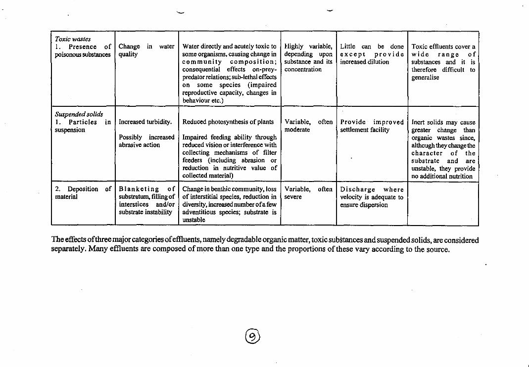
• NM • IS a MOM MN 11110 • I M O SI • a a
Toxic wastesI. Presence ofpoisonous substances
Change in waterquality
Water directly and acutely toxic tosome organisms, causing change in
Highly variable,depending upon
Little can be doneexcept provide
Toxic effluents cover awide range o f
community composition;consequential effects on-prey-predator relations; sub-lethal effectson some species (impairedreproductive capacity, changes inbehaviour etc.)
substance and itsconcentration
increased dilution substances and it istherefore difficult togeneralise
Suspended solidsParticles in Increased turbidity. Reduced photosynthesis of plants Variable, often Provide im proved Inert solids may cause
suspensionPossibly increasedabrasive action
Impaired feeding ability throughreduced vision or interference withcollecting mechanisms of filterfeeders (including abrasion orreduction in nutritive value ofcollected material)
moderate settlement facility greater change thanorganic wastes since,although they change thecharacter of thesubstrate and areunstable, they provideno additional nutrition
Deposition of Blanketing of Change in benthic community, loss Variable, often Discharge wherematerial substratum, filling of
interstices and/orsubstrate instability
of interstitial species, reduction indiversity, increased number of a fewadventitious species; substrate isunstable
severe velocity is adequate toensure dispersion
The effects ofthree major categories of effluents, namely degradable organic matter, toxic subttances and suspended solids, are consideredseparately. Many effluents are composed of more than one type and the proportions of these vary according to the source.
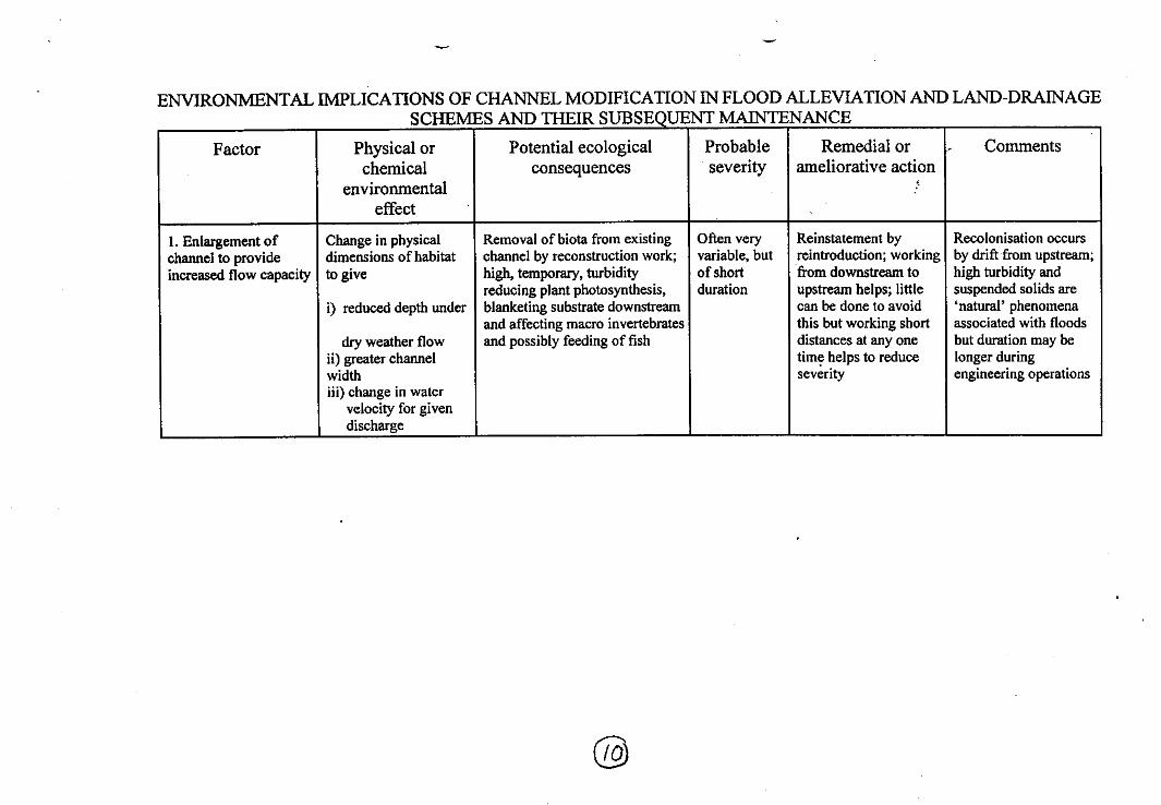
ENVIRONMENTAL IMPLICATIONS OF CHANNEL MODIFICATION IN FLOOD ALLEVIATION AND LAND-DRAINAGESCHEMES AND THEIR SUBSEQUENT MAINTENANCE
Factor Physical orchemical
environmentaleffect
Potential ecologicalconsequences
Probableseverity
Remedial orameliorative action
•,
Comments
1. Enlargement of Change in physical Removal of biota from existing Often very Reinstatement by Recolonisation occurschannel to provide dimensions of habitat channel by reconstruction work; variable, but reintroduction; working by drift from upstream;increased flow capacity to give high, temporary, turbidity of short from downstream to high turbidity and
i) reduced depth underreducing plant photosynthesis,blanketing substrate downstreamand affecting macro invertebrates
duration upstream helps; littlecan be done to avoidthis but working short
suspended solids are'natural' phenomenaassociated with floods
dry weather flowgreater channel
widthchange in watervelocity for givendischarge
and possibly feeding of fish distances at any onetime helps to reduceseverity
but duration may belonger duringengineering operations
00
a a a a • OIWI a a a a MO WM OM MI OM IS a •
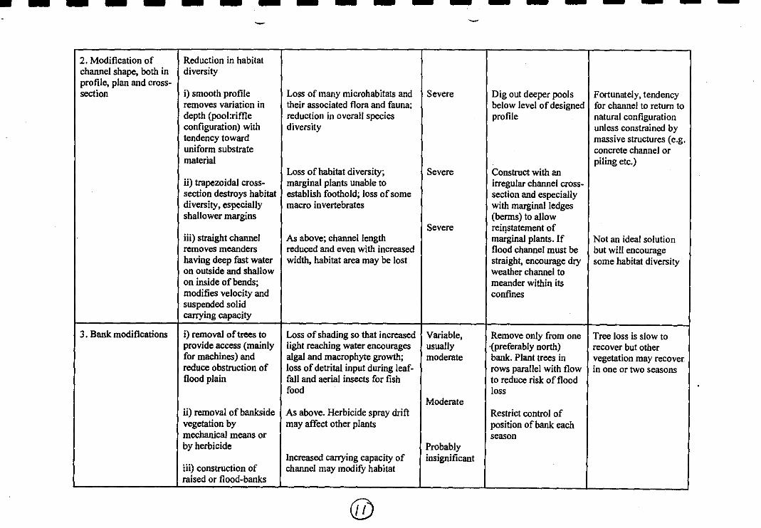
IS • a a a MI MI • MI 0 OP • IS • • el• •
2. Modification ofchannel shape, both inprofile, plan and cross-
Reduction in habitatdiversity
section smooth profile Loss of many microhabitats and Severe Dig out deeper pools Fortunately, tendencyremoves variation in their associated flora and fauna; below level of designed for channel to return todepth (pool:riffleconfiguration) withtendency towarduniform substratematerial
reduction in overall speciesdiversity
profile natural configurationunless constrained bymassive structures (e.g.concrete channel orpiling etc.)
trapezoidal cross-section destroys habitatdiversity, especiallyshallower margins
Loss of habitat diversity;marginal plants unable toestablish foothold; loss of somemacro invertebrates
Severe
Severe
Construct with anirregular channel cross-section and especiallywith marginal ledges(berms) to allowreinstatement of
iii) straight channel As above; channel length marginal plants. If Not an ideal solutionremoves meanders reduced and even with increased flood channel must be but will encouragehaving deep fast wateron outside and shallowon inside of bends;modifies velocity andsuspended solidcarrying capacity
width, habitat area may be lost straight, encourage dryweather channel tomeander within itsconfines
some habitat diversity
3. Bank modifications i) removal of trees toprovide access (mainly
Loss of shading so that increasedlight reaching water encourages
Variable,usually
Remove only from one•(preferably north)
Tree loss is slow torecover but other
for machines) and algal and macrophyte growth; moderate bank. Plant trees in vegetation may recoverreduce obstruction offlood plain
loss of detrital input during leaf-fall and aerial insects for fishfood
rows parallel with flowto reduce risk of floodloss
in one or two seasons
removal of banksidevegetation bymechanical means orby herbicide
construction ofraised or flood-banks
As above. Herbicide spray driftmay affect other plants
Increased carrying capacity ofchannel may modify habitat
Moderate
Probablyinsignificant
Restrict control ofposition of bank eachseason
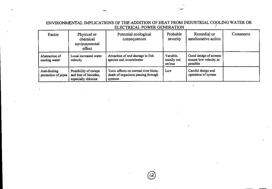
ENVIRONMENTAL IMPLICATIONS OF THE ADDITION OF HEAT FROM INDUSTRIAL COOLING WATER ORELECTRICAL POWER GENERATION
Factor Physical orchemical
environmentaleffect
Potential ecologicalconsequences
Probableseverity
Remedial orameliorative action
Comments
Abstraction ofcooling water
Local increased watervelocity
Attraction of and damage to fishspecies and invertebrates
Variable,usually notserious
Good design of screensensure low velocity aspossible
Anti-foulingprotection of pipes
Possibility of escapeand loss of biocides,especially chlorine
Toxic effects on normal river biota;death of organisms passing throughsystems
Low Careful design andoperation of system
MI NM a 11101 M. MO NM IMO OM NM 1 MI •IIII I=
• a la IS • • MOM MI • IIMI • I= a
Return of heatedwater
Elevation of watertemperature
Heat stress or death of sensitivespecies; acceleration of growth, shiftsin timing of life cycles, increased ratesof feeding of fish, invertebrates, etc.
Low Minimise temperaturedifferences
Heat stress mayrender some speciesmore prone todisease
Enhanced microorganism respiration,especially in organically enrichedwaters, reducing dissolved oxygenlevels
Increased toxicity of many poisons
Moderate
Variable
Variable
Cooling towersoften provide netbenefit throughaeration oforganicallyenriched water
Attraction of mobile species (esp.fish) to thermal plume, repulsion of
Critical temperaturefor repulsion of
others
Survival of exotic species,accidentally or deliberatelyintroduced, to compete with
Usually notserious
Complete removalrarely possible
many species is30°CPopulations mayadapt to lower
Lowering of indigenous species temperatures bydissolved gas solubility
Oxygen Moderate Minimise temperatureselection and
Effects on sensitive biota, especially
differences; provideaeration or mixingfacilities
spread further
Nitrogen important when biochemical oxygendemand is elevated
low
`Gas bubble disease' in fish andinvertebrates

WWF MALAYSIARESOURCE LIBRARY
1
I