#12: groundwater (hydrogeology) -...
TRANSCRIPT
dwzwy-geologi-2010
#12: Groundwater
(Hydrogeology)
Assoc. Prof. Dr. Wan Zuhairi Yaacob
Program Geologi
UKM
110/20/2010
dwzwy-geologi-2010
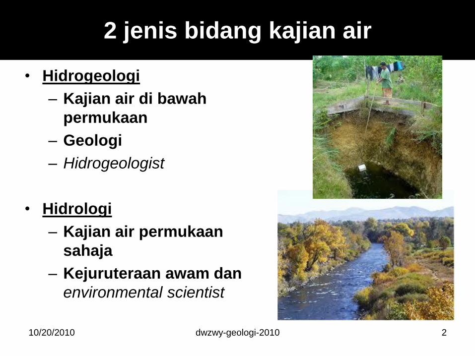
• Hidrogeologi
– Kajian air di bawah
permukaan
– Geologi
– Hidrogeologist
• Hidrologi
– Kajian air permukaan
sahaja
– Kejuruteraan awam dan
environmental scientist
2
2 jenis bidang kajian air
10/20/2010
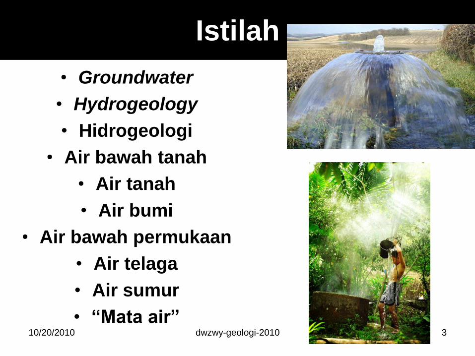
Istilah
• Groundwater
• Hydrogeology
• Hidrogeologi
• Air bawah tanah
• Air tanah
• Air bumi
• Air bawah permukaan
• Air telaga
• Air sumur
• ―Mata air‖ 10/20/2010 dwzwy-geologi-2010 3
Air adalah pelarut istimewa kerana:
– Molekul air tertarik antara satu
sama lain secara ikatan hidrogen
– Air adalah dwi-polar (iaitu
mempunyai dua cas)
– Molekul air tertarik pada
permukaan pepejal yang bercas
positif dan negatif
– Air adalah bahan pepejal yang
lebih ringan daripada bahan
cecair
10/20/2010 dwzwy-geologi-2010 4
Water as a Unique Liquid
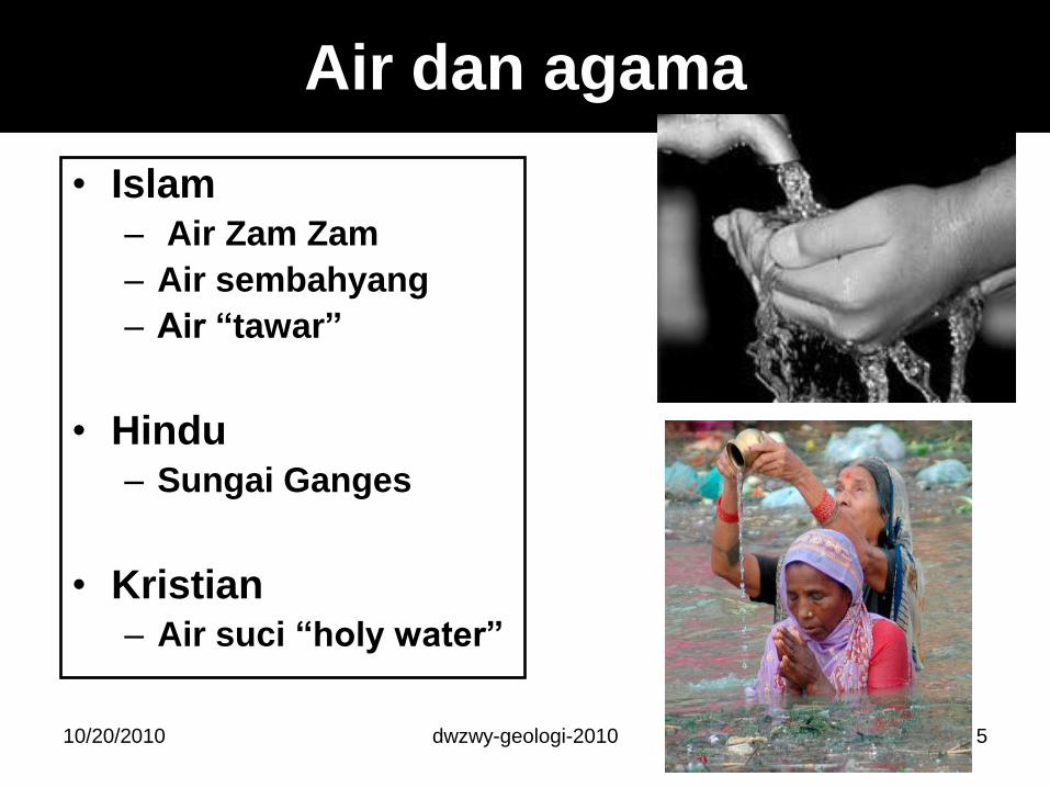
Air dan agama
• Islam– Air Zam Zam
– Air sembahyang
– Air ―tawar‖
• Hindu– Sungai Ganges
• Kristian– Air suci ―holy water‖
10/20/2010 5dwzwy-geologi-2010
dwzwy-geologi-2010
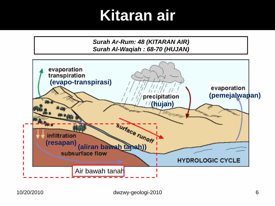
Kitaran air
6
Surah Ar-Rum: 48 (KITARAN AIR)
Surah Al-Waqiah : 68-70 (HUJAN)
Air bawah tanah
(hujan)
(pemejalwapan)
(evapo-transpirasi)
(resapan)(aliran bawah tanah))
10/20/2010
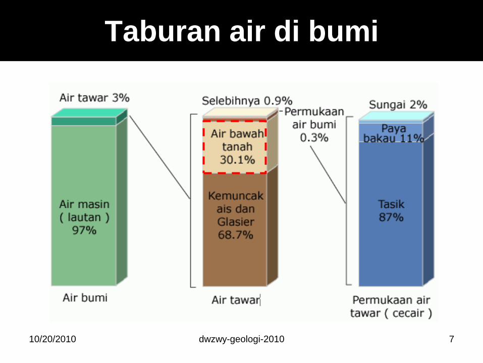
Taburan air di bumi
10/20/2010 7dwzwy-geologi-2010
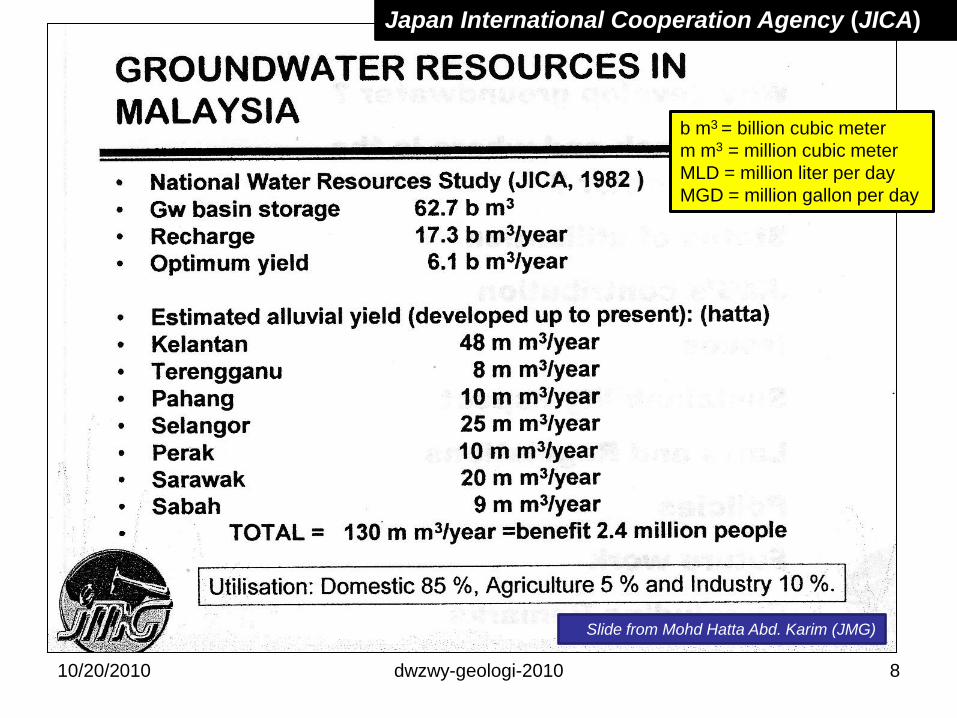
Slide from Mohd Hatta Abd. Karim (JMG)
b m3 = billion cubic meter
m m3 = million cubic meter
MLD = million liter per day
MGD = million gallon per day
Japan International Cooperation Agency (JICA)
10/20/2010 8dwzwy-geologi-2010
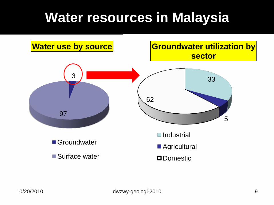
Water resources in Malaysia
33
5
62
Groundwater utilization by sector
Industrial
Agricultural
Domestic
3
97
Water use by source
Groundwater
Surface water
10/20/2010 9dwzwy-geologi-2010
dwzwy-geologi-2010
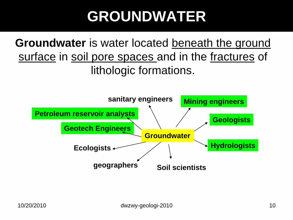
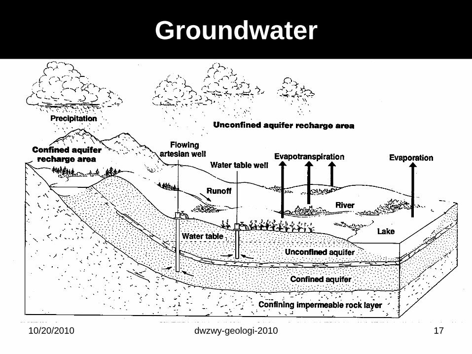
GROUNDWATER
Groundwater is water located beneath the ground
surface in soil pore spaces and in the fractures of
lithologic formations.
Geologists
Hydrologists
Soil scientistsgeographers
Ecologists
Geotech Engineers
Mining engineerssanitary engineers
Petroleum reservoir analysts
Groundwater
1010/20/2010
dwzwy-geologi-2010 1110/20/2010
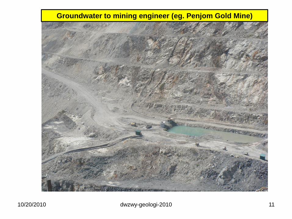
Groundwater to mining engineer (eg. Penjom Gold Mine)
drwzwy::2010_2011
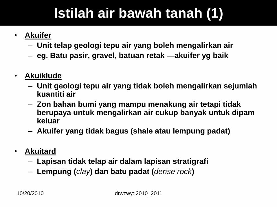
Istilah air bawah tanah (1)
• Akuifer
– Unit telap geologi tepu air yang boleh mengalirkan air
– eg. Batu pasir, gravel, batuan retak —akuifer yg baik
• Akuiklude
– Unit geologi tepu air yang tidak boleh mengalirkan sejumlahkuantiti air
– Zon bahan bumi yang mampu menakung air tetapi tidakberupaya untuk mengalirkan air cukup banyak untuk dipamkeluar
– Akuifer yang tidak bagus (shale atau lempung padat)
• Akuitard
– Lapisan tidak telap air dalam lapisan stratigrafi
– Lempung (clay) dan batu padat (dense rock)
10/20/2010
drwzwy::2010_2011
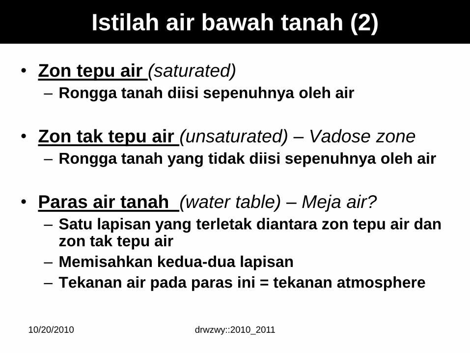
Istilah air bawah tanah (2)
• Zon tepu air (saturated)– Rongga tanah diisi sepenuhnya oleh air
• Zon tak tepu air (unsaturated) – Vadose zone– Rongga tanah yang tidak diisi sepenuhnya oleh air
• Paras air tanah (water table) – Meja air?– Satu lapisan yang terletak diantara zon tepu air dan
zon tak tepu air
– Memisahkan kedua-dua lapisan
– Tekanan air pada paras ini = tekanan atmosphere
10/20/2010
drwzwy::2010_2011
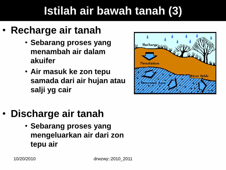
• Recharge air tanah• Sebarang proses yang
menambah air dalam
akuifer
• Air masuk ke zon tepu
samada dari air hujan atau
salji yg cair
• Discharge air tanah• Sebarang proses yang
mengeluarkan air dari zon
tepu air
Istilah air bawah tanah (3)
10/20/2010
drwzwy::2010_2011
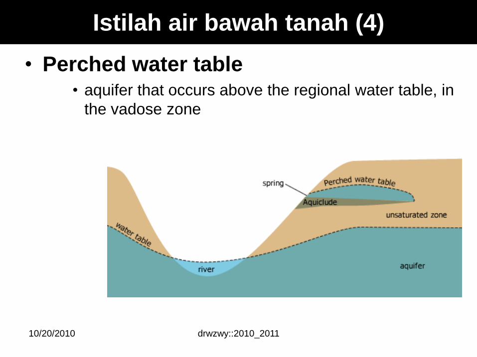
• Perched water table • aquifer that occurs above the regional water table, in
the vadose zone
Istilah air bawah tanah (4)
10/20/2010
drwzwy::2010_2011
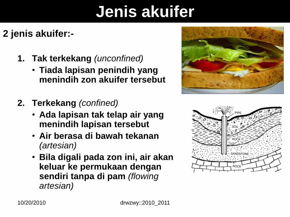
2 jenis akuifer:-
1. Tak terkekang (unconfined)
• Tiada lapisan penindih yang menindih zon akuifer tersebut
2. Terkekang (confined)
• Ada lapisan tak telap air yang menindih lapisan tersebut
• Air berasa di bawah tekanan(artesian)
• Bila digali pada zon ini, air akankeluar ke permukaan dengansendiri tanpa di pam (flowing artesian)
Jenis akuifer
10/20/2010
dwzwy-geologi-2010
Groundwater
1710/20/2010
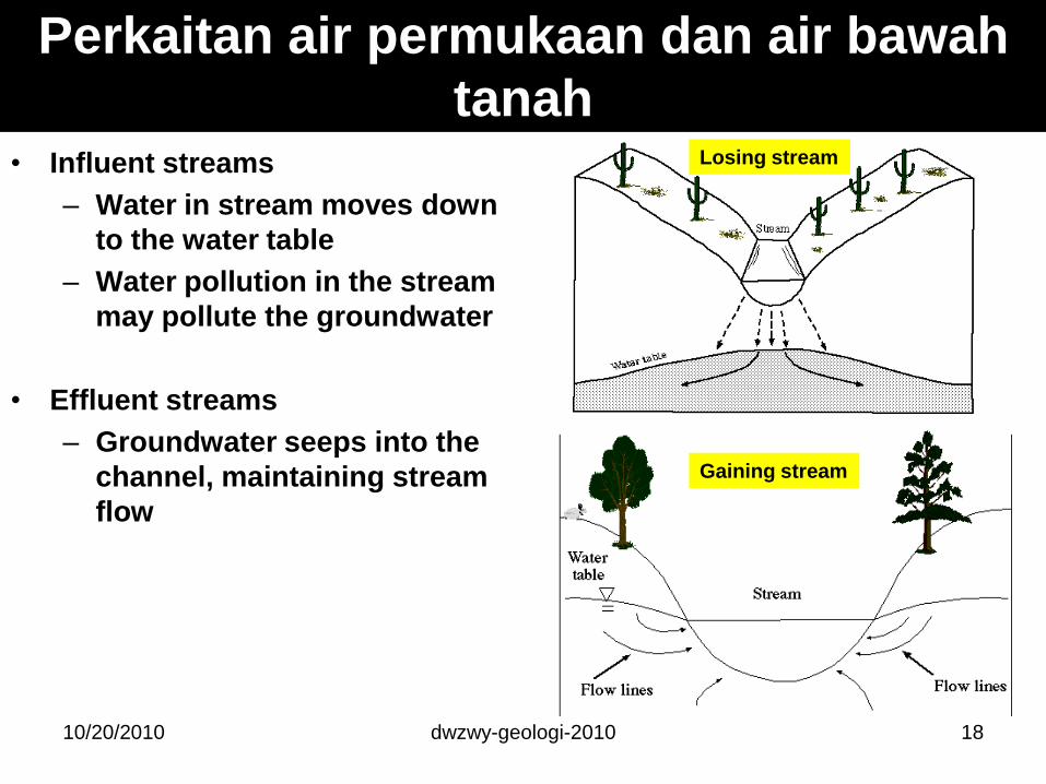
Perkaitan air permukaan dan air bawah
tanah• Influent streams
– Water in stream moves down
to the water table
– Water pollution in the stream
may pollute the groundwater
• Effluent streams
– Groundwater seeps into the
channel, maintaining stream
flow
10/20/2010 dwzwy-geologi-2010 18
Gaining stream
Losing stream

10/20/2010 dwzwy-geologi-2010 19
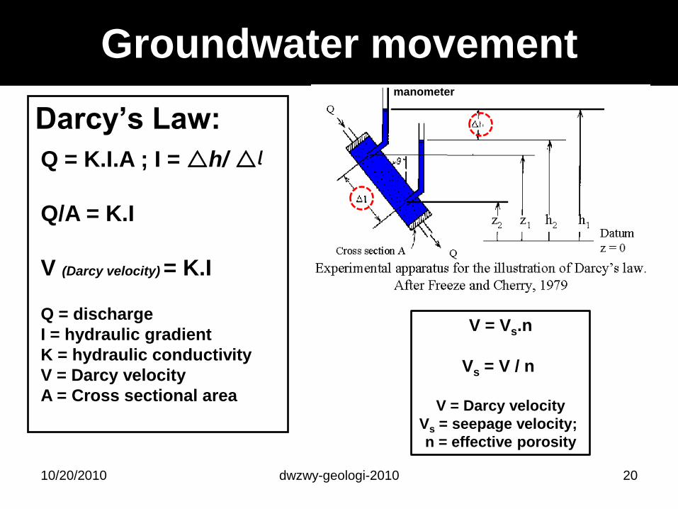
Groundwater movement
Darcy’s Law:
10/20/2010 dwzwy-geologi-2010 20
Q = K.I.A ; I = h/ᶩ
Q/A = K.I
V (Darcy velocity) = K.I
Q = discharge
I = hydraulic gradient
K = hydraulic conductivity
V = Darcy velocity
A = Cross sectional area
V = Vs.n
Vs = V / n
V = Darcy velocity
Vs = seepage velocity;
n = effective porosity
manometer
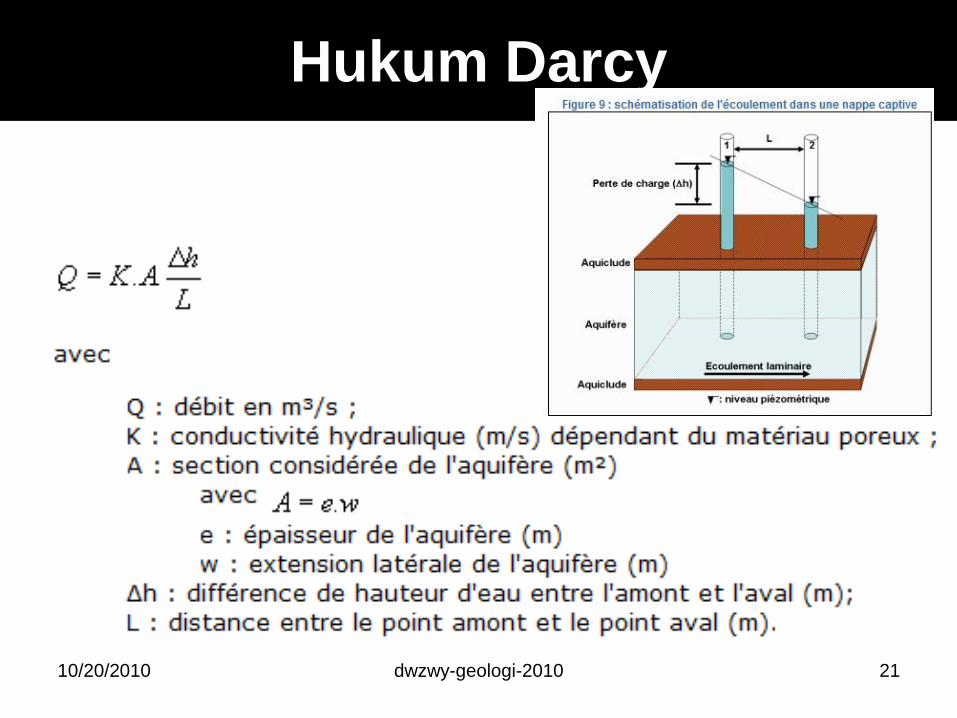
Hukum Darcy
10/20/2010 dwzwy-geologi-2010 21
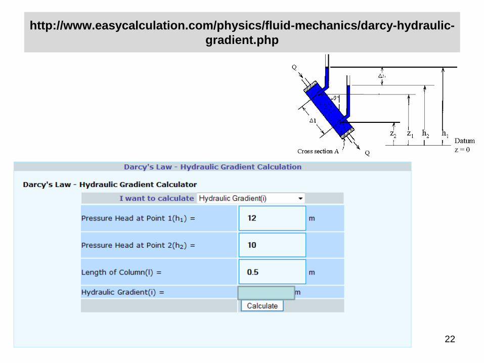
http://www.easycalculation.com/physics/fluid-mechanics/darcy-hydraulic-
gradient.php
10/20/2010 dwzwy-geologi-2010 22
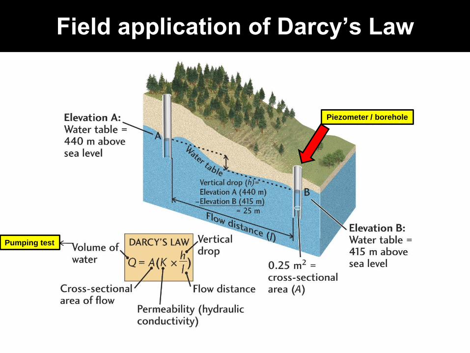
Field application of Darcy’s Law
Pumping test
Piezometer / borehole
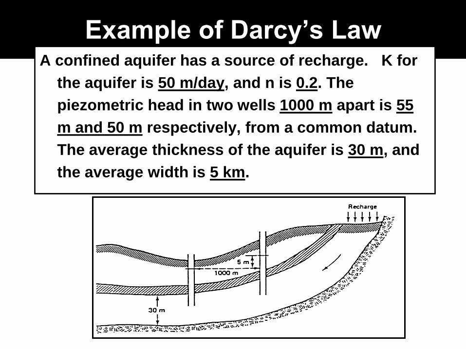
Example of Darcy’s LawA confined aquifer has a source of recharge. K for
the aquifer is 50 m/day, and n is 0.2. The
piezometric head in two wells 1000 m apart is 55
m and 50 m respectively, from a common datum.
The average thickness of the aquifer is 30 m, and
the average width is 5 km.
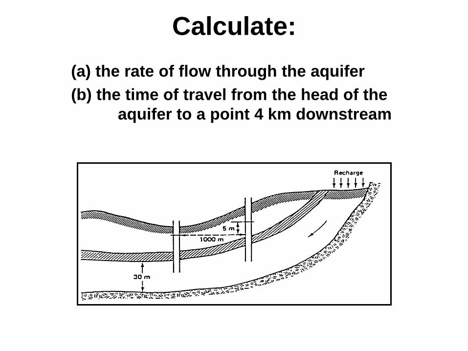
Calculate:
(a) the rate of flow through the aquifer
(b) the time of travel from the head of the
aquifer to a point 4 km downstream
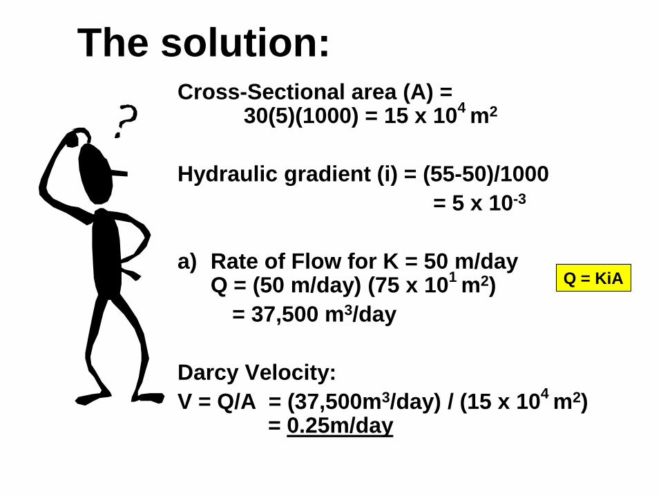
The solution:Cross-Sectional area (A) =
30(5)(1000) = 15 x 104
m2
Hydraulic gradient (i) = (55-50)/1000
= 5 x 10⁻³
a) Rate of Flow for K = 50 m/dayQ = (50 m/day) (75 x 10
1 m2)
= 37,500 m3/day
Darcy Velocity:
V = Q/A = (37,500m3/day) / (15 x 104
m2) = 0.25m/day
Q = KiA
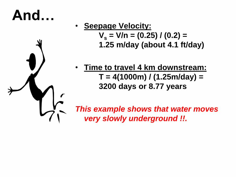
And…• Seepage Velocity:
Vs = V/n = (0.25) / (0.2) =
1.25 m/day (about 4.1 ft/day)
• Time to travel 4 km downstream:
T = 4(1000m) / (1.25m/day) =
3200 days or 8.77 years
This example shows that water moves
very slowly underground !!.
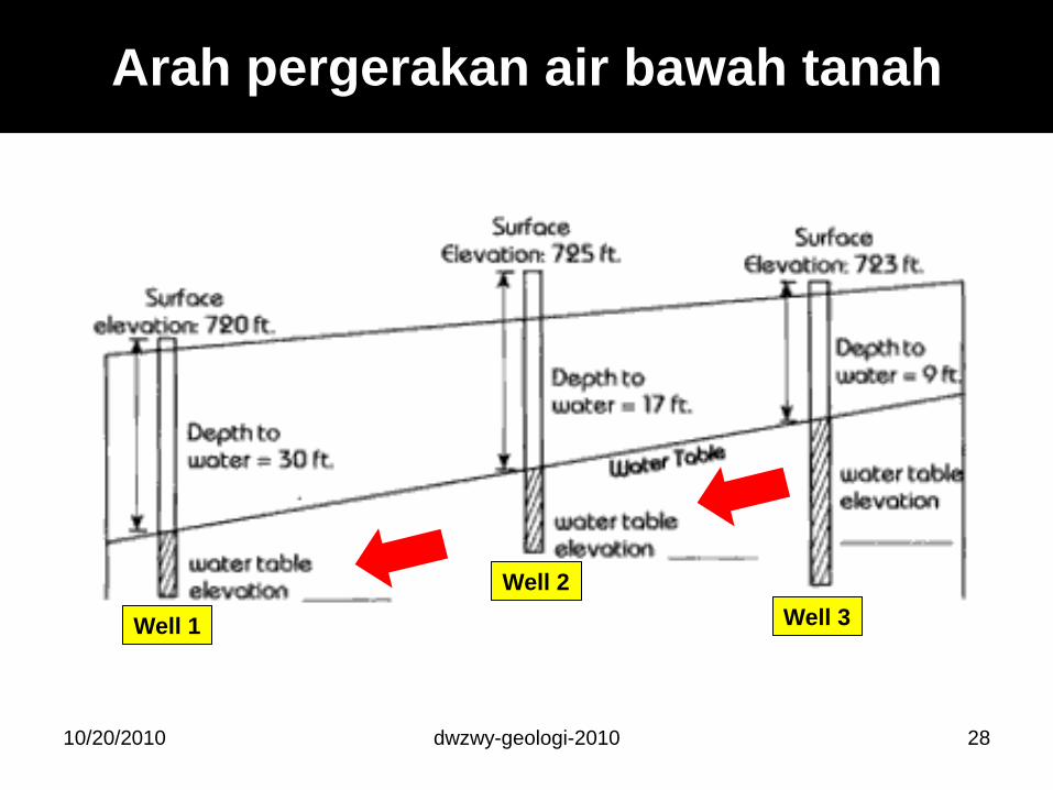
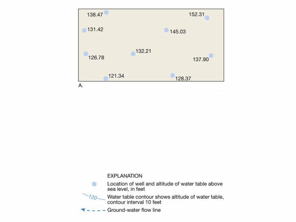
Arah pergerakan air bawah tanah
10/20/2010 dwzwy-geologi-2010 28
Well 1
Well 2
Well 3
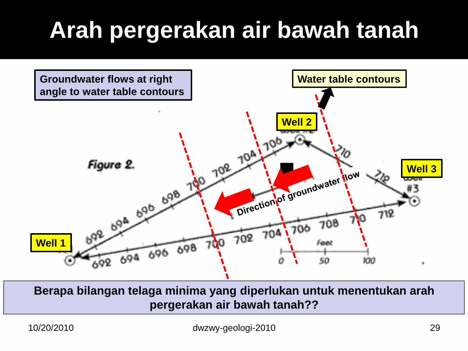
10/20/2010 dwzwy-geologi-2010 29
Well 1
Well 2
Well 3
Arah pergerakan air bawah tanah
Groundwater flows at right
angle to water table contours
Water table contours
Berapa bilangan telaga minima yang diperlukan untuk menentukan arah
pergerakan air bawah tanah??
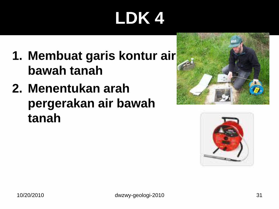
LDK 4
1. Membuat garis kontur air
bawah tanah
2. Menentukan arah
pergerakan air bawah
tanah
10/20/2010 dwzwy-geologi-2010 31
dwzwy-geologi-2010
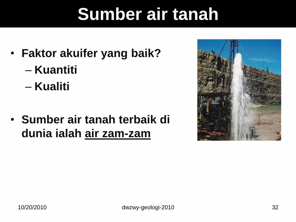
Sumber air tanah
• Faktor akuifer yang baik?
– Kuantiti
– Kualiti
• Sumber air tanah terbaik di
dunia ialah air zam-zam
3210/20/2010
Apa yang mengawal kuantiti?
1. Porositi (rongga)• menentukan jumlah air yang boleh disimpan
2. Saiz akuifer• ketebalan dan keluasan
3. Ketertelapan (permeability @ hydraulic conductivity)
• Keupayaan sesuatu medium tanah untuk mengalirkanair melaluinya
• mempengaruhi kadar recharge dan keupayaan untukdipam.
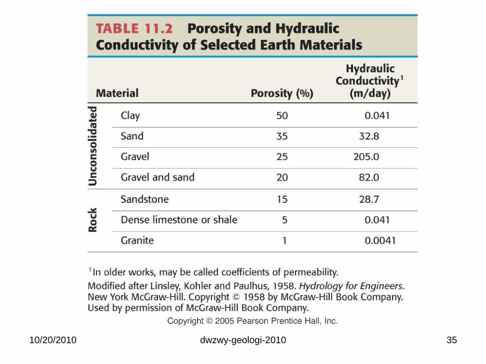
• Contoh: – Pasir – ketertelapan tinggi (2 x 10⁻² m/sec)
– Lempung/lodak – ketertelapan rendah (1 x 10⁻⁹ m/sec)
10/20/2010 33dwzwy-geologi-2010
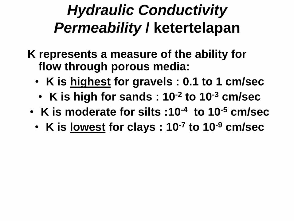
Hydraulic Conductivity
Permeability / ketertelapan
K represents a measure of the ability for flow through porous media:
• K is highest for gravels : 0.1 to 1 cm/sec
• K is high for sands : 10-2 to 10-3 cm/sec
• K is moderate for silts :10-4 to 10-5 cm/sec
• K is lowest for clays : 10-7 to 10-9 cm/sec
10/20/2010 dwzwy-geologi-2010 35
dwzwy-geologi-2010
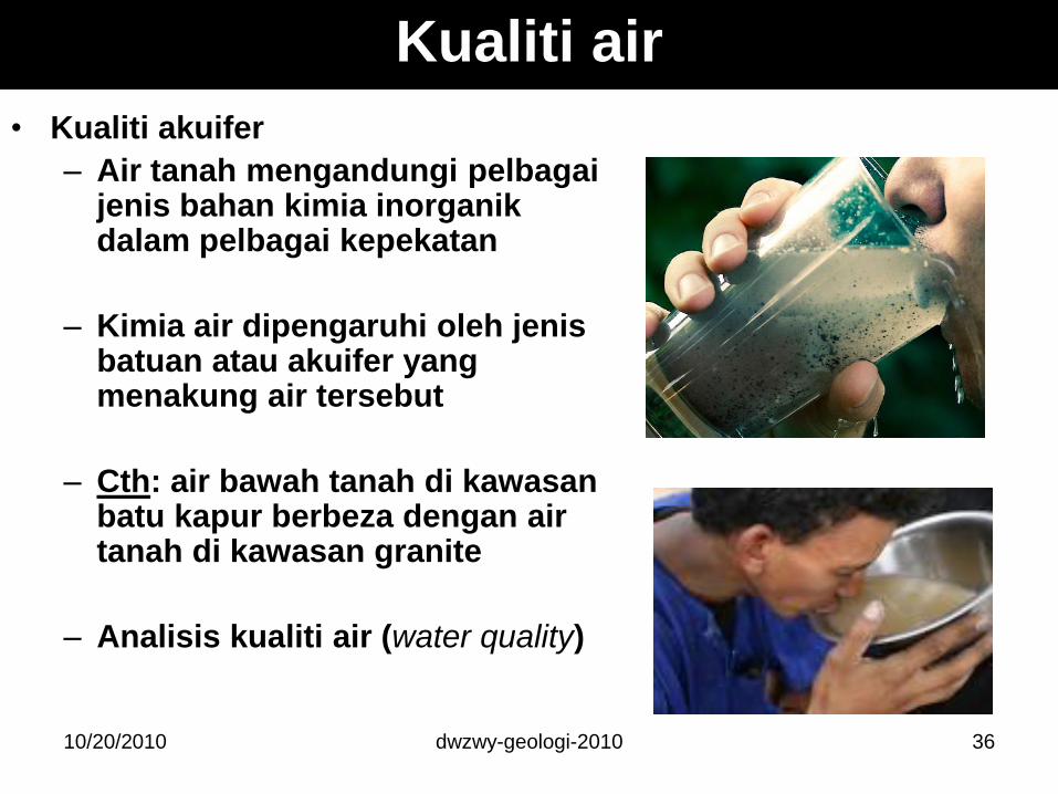
Kualiti air
• Kualiti akuifer
– Air tanah mengandungi pelbagaijenis bahan kimia inorganikdalam pelbagai kepekatan
– Kimia air dipengaruhi oleh jenisbatuan atau akuifer yang menakung air tersebut
– Cth: air bawah tanah di kawasanbatu kapur berbeza dengan air tanah di kawasan granite
– Analisis kualiti air (water quality)
3610/20/2010
dwzwy-geologi-2010
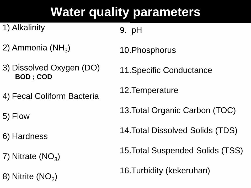
Water quality parameters
3710/20/2010
1) Alkalinity
2) Ammonia (NH3)
3) Dissolved Oxygen (DO) BOD ; COD
4) Fecal Coliform Bacteria
5) Flow
6) Hardness
7) Nitrate (NO3)
8) Nitrite (NO2)
9. pH
10.Phosphorus
11.Specific Conductance
12.Temperature
13.Total Organic Carbon (TOC)
14.Total Dissolved Solids (TDS)
15.Total Suspended Solids (TSS)
16.Turbidity (kekeruhan)
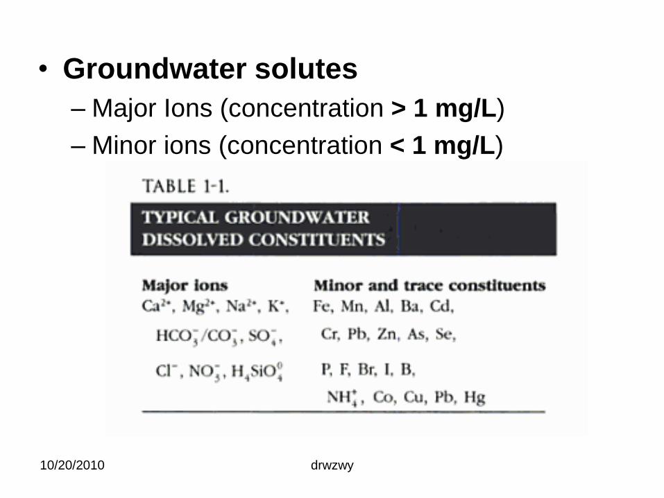
• Groundwater solutes
– Major Ions (concentration > 1 mg/L)
– Minor ions (concentration < 1 mg/L)
10/20/2010 drwzwy
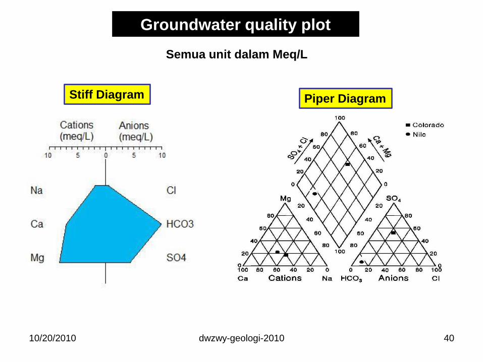
Groundwater quality plot
dwzwy-geologi-2010 40
Stiff Diagram Piper Diagram
10/20/2010
Semua unit dalam Meq/L
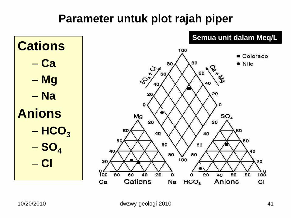
Parameter untuk plot rajah piper
Cations
– Ca
– Mg
– Na
Anions
– HCO3
– SO4
– Cl
10/20/2010 dwzwy-geologi-2010 41
Semua unit dalam Meq/L
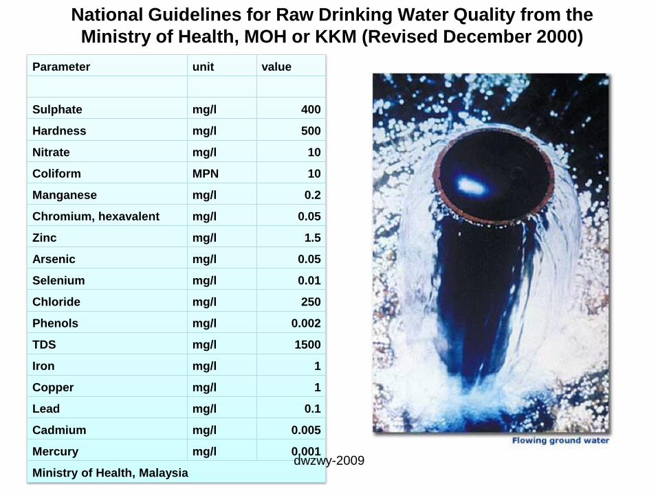
National Guidelines for Raw Drinking Water Quality from the
Ministry of Health, MOH or KKM (Revised December 2000)
Parameter unit value
Sulphate mg/l 400
Hardness mg/l 500
Nitrate mg/l 10
Coliform MPN 10
Manganese mg/l 0.2
Chromium, hexavalent mg/l 0.05
Zinc mg/l 1.5
Arsenic mg/l 0.05
Selenium mg/l 0.01
Chloride mg/l 250
Phenols mg/l 0.002
TDS mg/l 1500
Iron mg/l 1
Copper mg/l 1
Lead mg/l 0.1
Cadmium mg/l 0.005
Mercury mg/l 0.001
Ministry of Health, Malaysiadwzwy-2009
dwzwy-geologi-2010
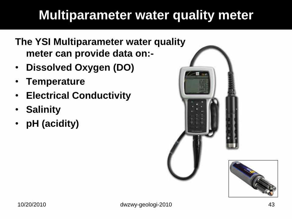
Multiparameter water quality meter
4310/20/2010
The YSI Multiparameter water quality
meter can provide data on:-
• Dissolved Oxygen (DO)
• Temperature
• Electrical Conductivity
• Salinity
• pH (acidity)
dwzwy-geologi-2010
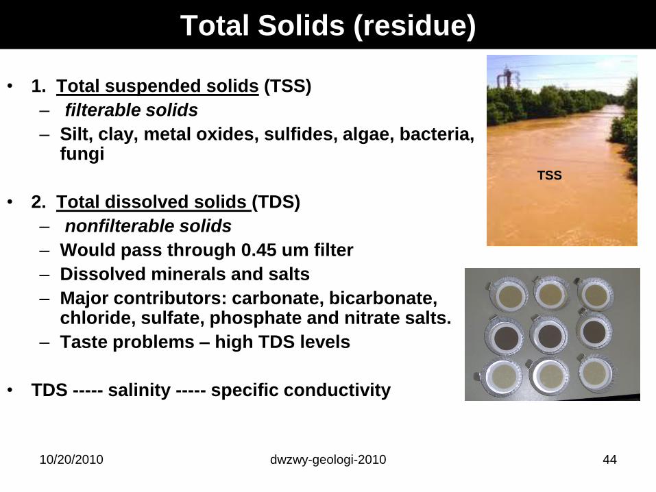
Total Solids (residue)
• 1. Total suspended solids (TSS)
– filterable solids
– Silt, clay, metal oxides, sulfides, algae, bacteria, fungi
• 2. Total dissolved solids (TDS)
– nonfilterable solids
– Would pass through 0.45 um filter
– Dissolved minerals and salts
– Major contributors: carbonate, bicarbonate, chloride, sulfate, phosphate and nitrate salts.
– Taste problems – high TDS levels
• TDS ----- salinity ----- specific conductivity
4410/20/2010
TSS
dwzwy-geologi-2010
Jumlah Pepejal Terlarut
Total Dissolved Solids (TDS)
Simple groundwater classification based on TDS:
Category TDS (mg/l)
Fresh water 0-1000
Brackish water 1000-10,000
Saline water 10,000-100,000
Brine water >100,000
Note: water with 2000-3000 mg/l TDS – too salty to drink
4510/20/2010
dwzwy-geologi-2010
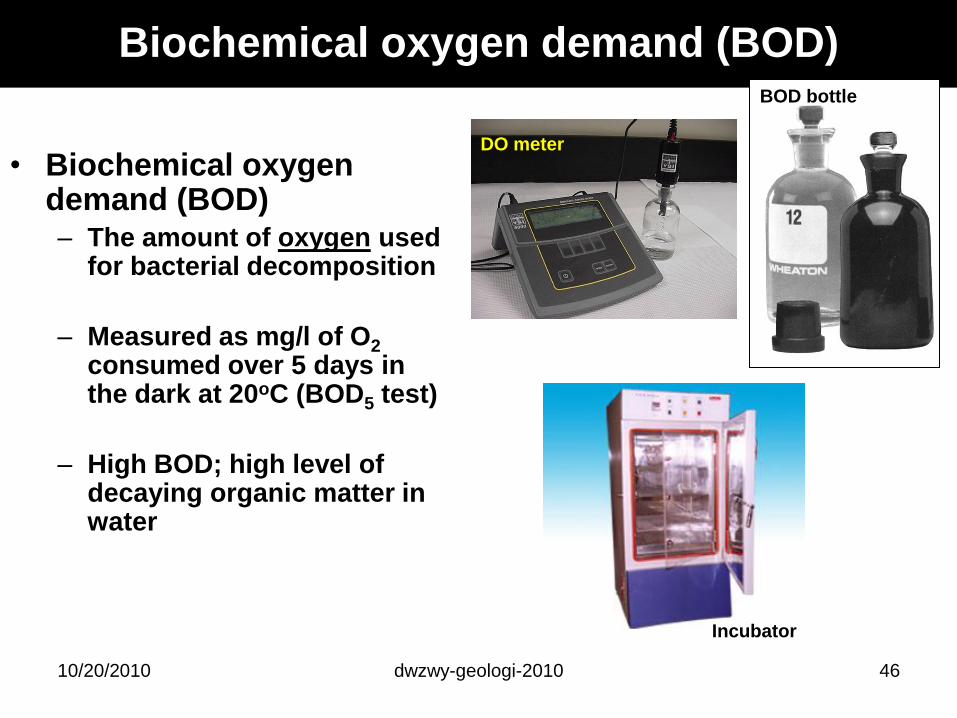
Biochemical oxygen demand (BOD)
• Biochemical oxygen demand (BOD)– The amount of oxygen used
for bacterial decomposition
– Measured as mg/l of O2
consumed over 5 days in the dark at 20oC (BOD5 test)
– High BOD; high level of decaying organic matter in water
4610/20/2010
Incubator
DO meter
BOD bottle
dwzwy-geologi-2010
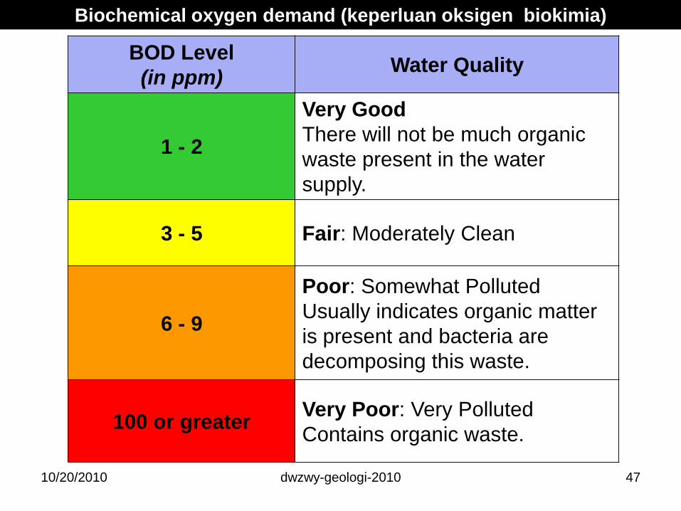
BOD Level
(in ppm)Water Quality
1 - 2
Very Good
There will not be much organic
waste present in the water
supply.
3 - 5 Fair: Moderately Clean
6 - 9
Poor: Somewhat Polluted
Usually indicates organic matter
is present and bacteria are
decomposing this waste.
100 or greaterVery Poor: Very Polluted
Contains organic waste.
Biochemical oxygen demand (keperluan oksigen biokimia)
4710/20/2010
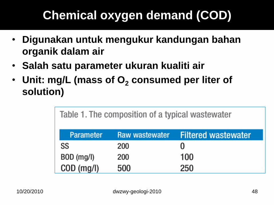
Chemical oxygen demand (COD)
• Digunakan untuk mengukur kandungan bahan
organik dalam air
• Salah satu parameter ukuran kualiti air
• Unit: mg/L (mass of O2 consumed per liter of
solution)
10/20/2010 dwzwy-geologi-2010 48
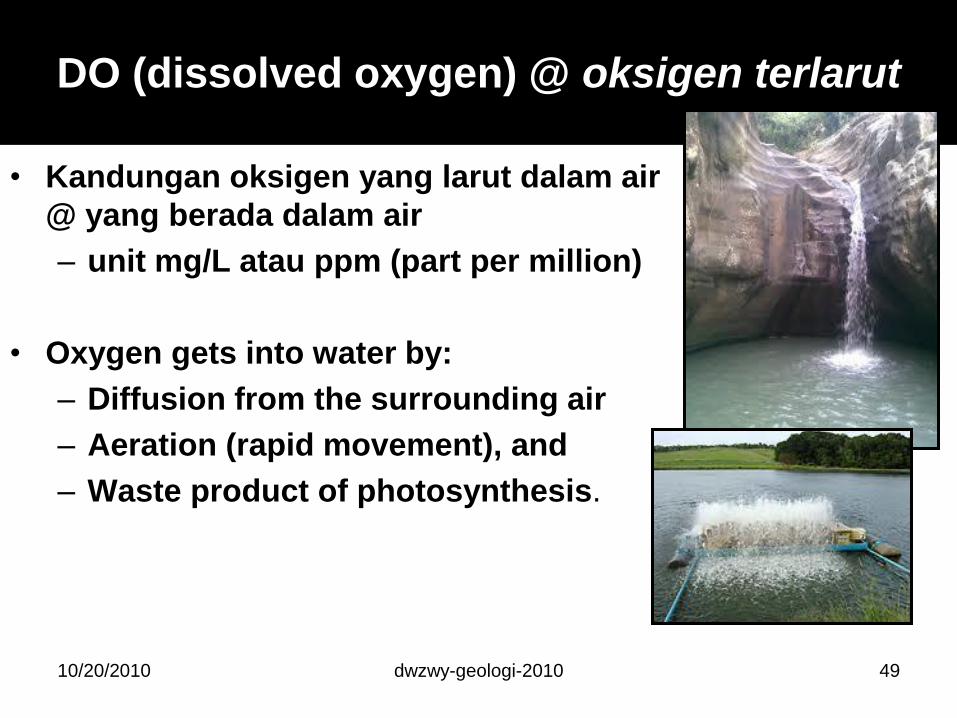
DO (dissolved oxygen) @ oksigen terlarut
• Kandungan oksigen yang larut dalam air
@ yang berada dalam air
– unit mg/L atau ppm (part per million)
• Oxygen gets into water by:
– Diffusion from the surrounding air
– Aeration (rapid movement), and
– Waste product of photosynthesis.
dwzwy-geologi-2010 4910/20/2010
dwzwy-geologi-2010
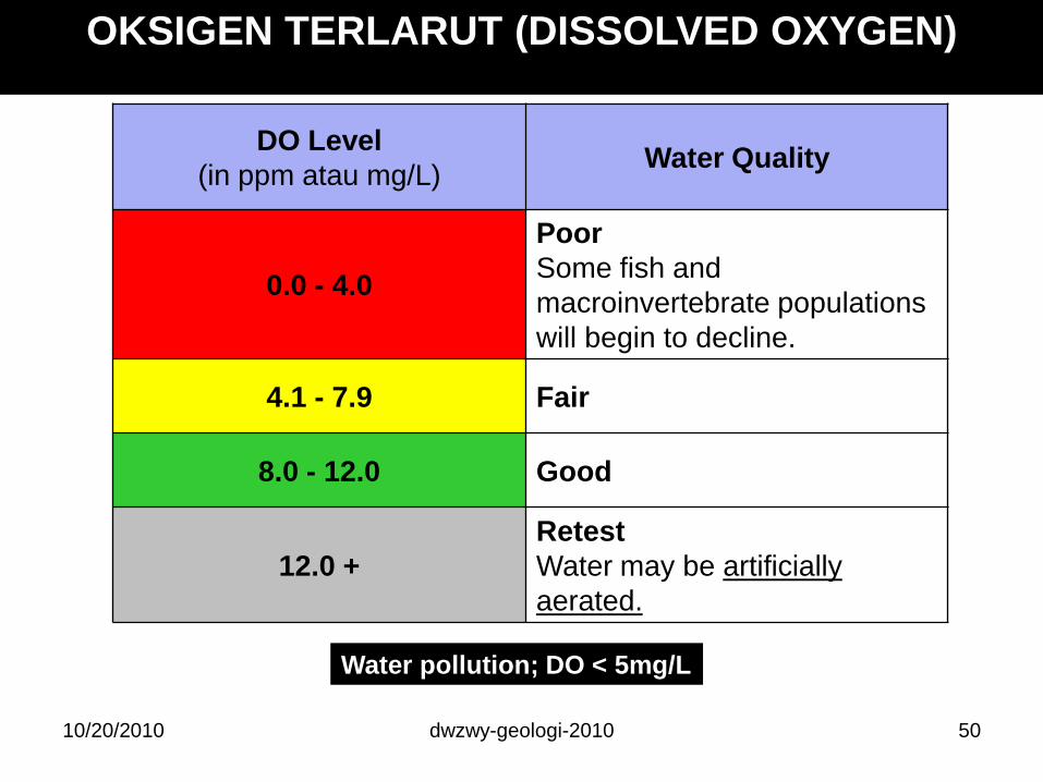
DO Level
(in ppm atau mg/L)Water Quality
0.0 - 4.0
Poor
Some fish and
macroinvertebrate populations
will begin to decline.
4.1 - 7.9 Fair
8.0 - 12.0 Good
12.0 +
Retest
Water may be artificially
aerated.
Water pollution; DO < 5mg/L
OKSIGEN TERLARUT (DISSOLVED OXYGEN)
5010/20/2010
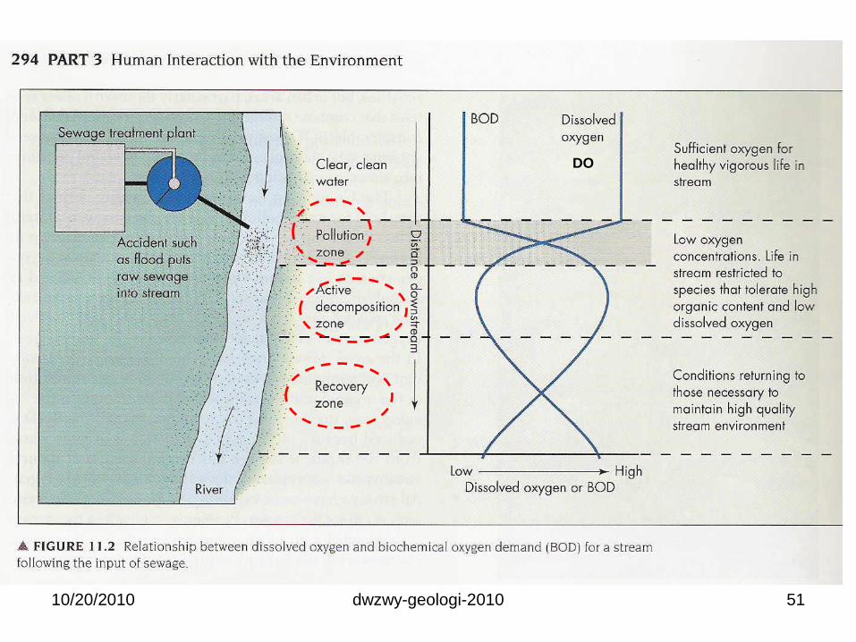
dwzwy-geologi-2010 5110/20/2010
DO

Air Permukaan (surface water)
dwzwy-geologi-2010 5210/20/2010
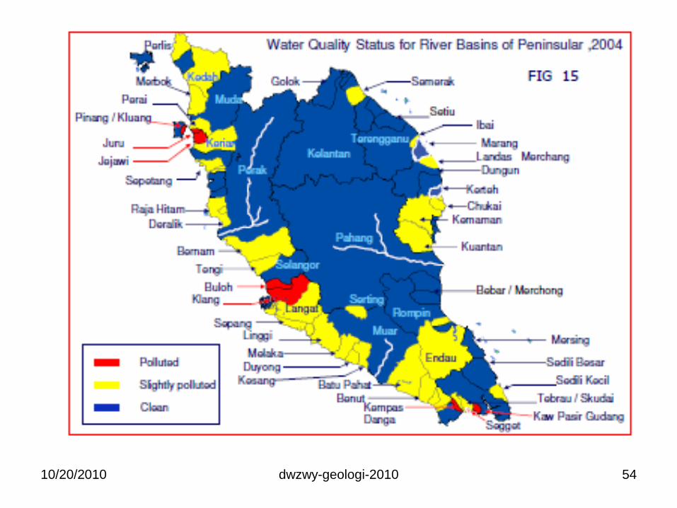
Not so bad ??
dwzwy-geologi-2010 5410/20/2010
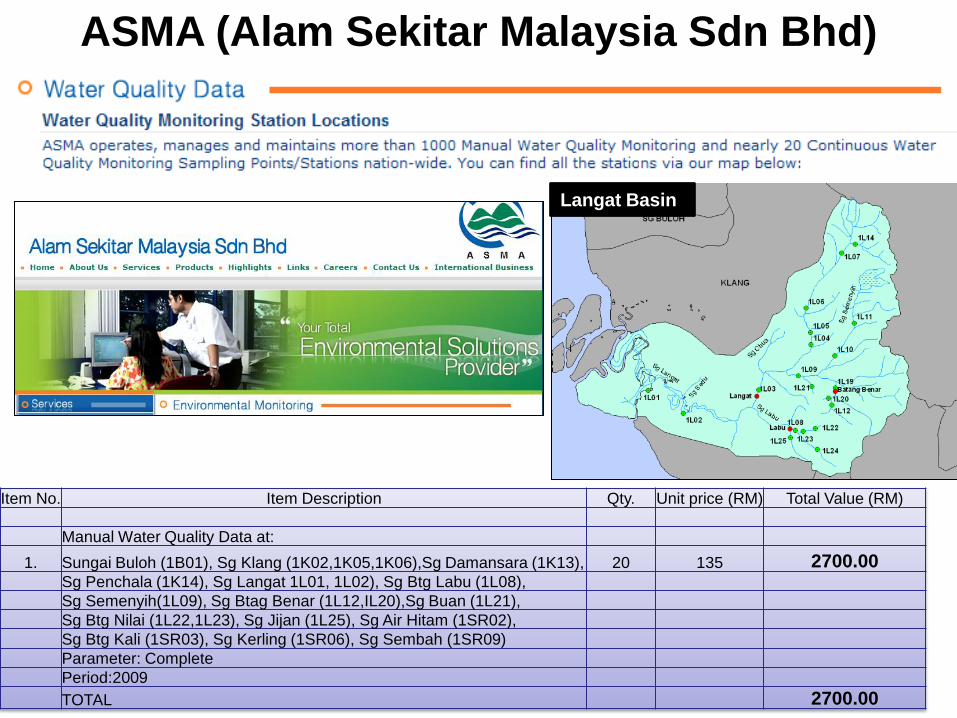
ASMA (Alam Sekitar Malaysia Sdn Bhd)
Langat Basin
dwzwy-geologi-201010/20/2010 55
Item No. Item Description Qty. Unit price (RM) Total Value (RM)
Manual Water Quality Data at:
1. Sungai Buloh (1B01), Sg Klang (1K02,1K05,1K06),Sg Damansara (1K13), 20 135 2700.00Sg Penchala (1K14), Sg Langat 1L01, 1L02), Sg Btg Labu (1L08),
Sg Semenyih(1L09), Sg Btag Benar (1L12,IL20),Sg Buan (1L21),
Sg Btg Nilai (1L22,1L23), Sg Jijan (1L25), Sg Air Hitam (1SR02),
Sg Btg Kali (1SR03), Sg Kerling (1SR06), Sg Sembah (1SR09)
Parameter: Complete
Period:2009
TOTAL 2700.00
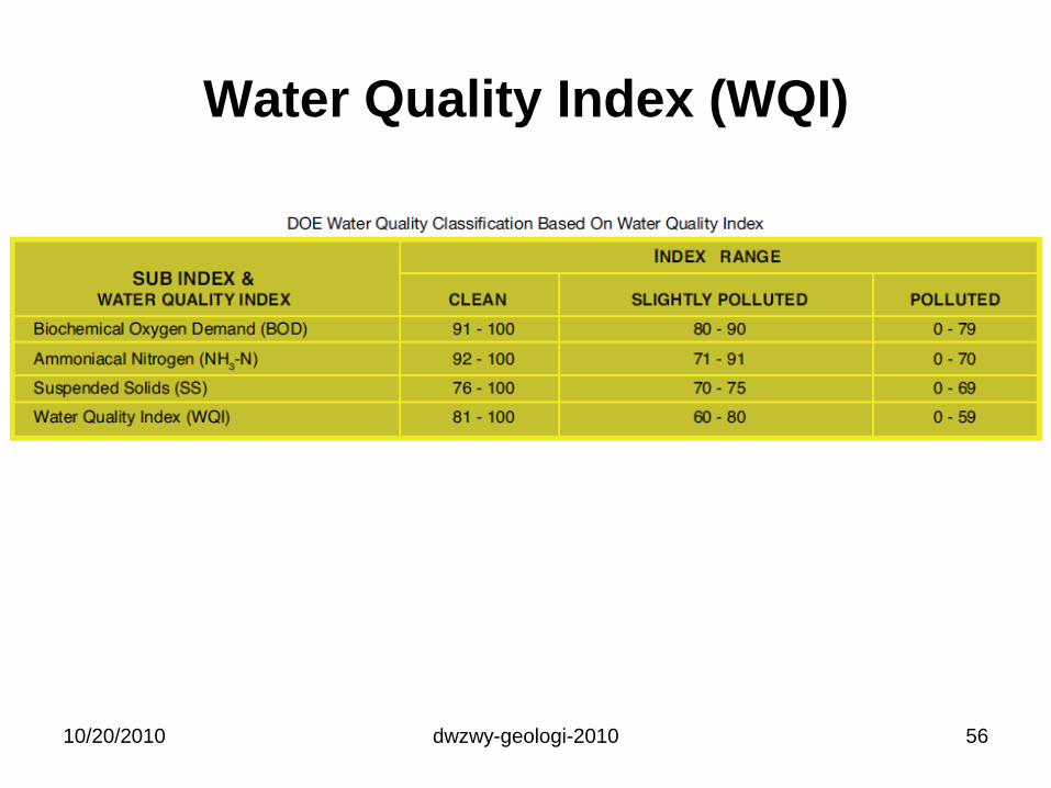
Water Quality Index (WQI)
10/20/2010 dwzwy-geologi-2010 56
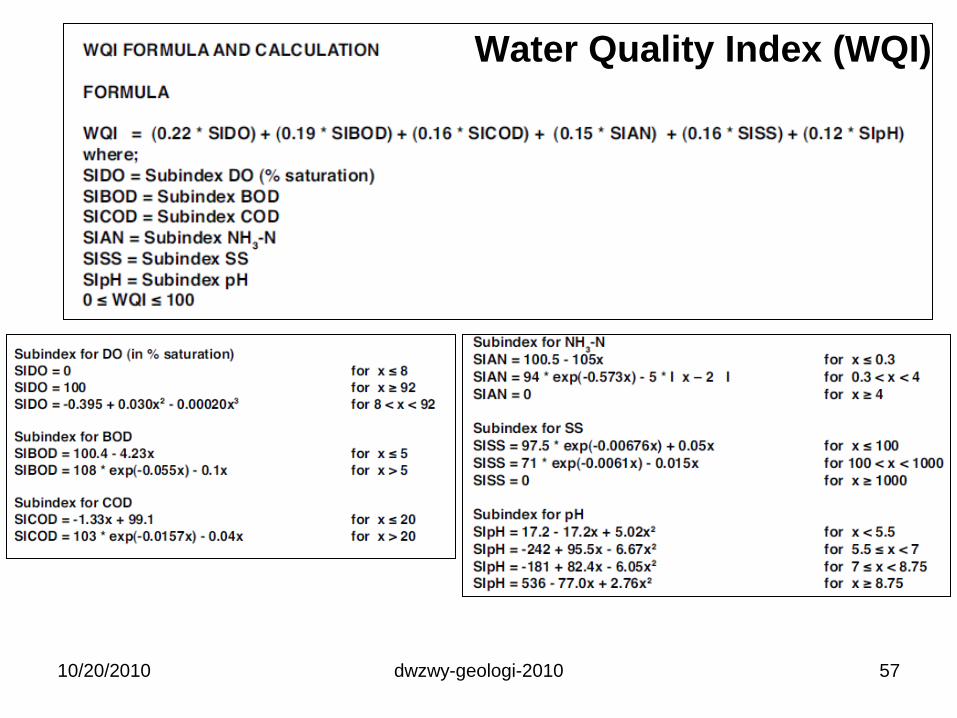
10/20/2010 dwzwy-geologi-2010 57
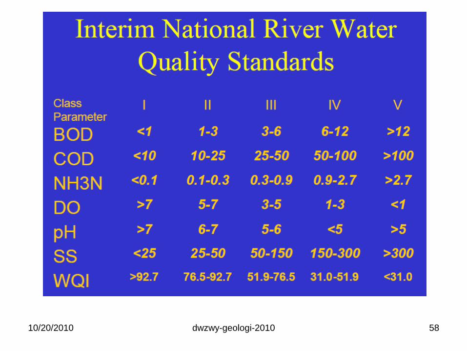
Water Quality Index (WQI)
10/20/2010 dwzwy-geologi-2010 58
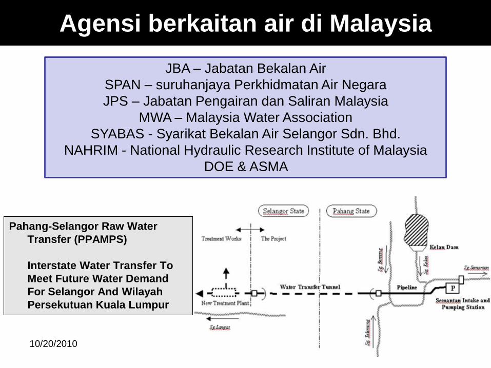
Agensi berkaitan air di Malaysia
Pahang-Selangor Raw Water
Transfer (PPAMPS)
Interstate Water Transfer To
Meet Future Water Demand
For Selangor And Wilayah
Persekutuan Kuala Lumpur
10/20/2010 dwzwy-geologi-2010 59
JBA – Jabatan Bekalan Air
SPAN – suruhanjaya Perkhidmatan Air Negara
JPS – Jabatan Pengairan dan Saliran Malaysia
MWA – Malaysia Water Association
SYABAS - Syarikat Bekalan Air Selangor Sdn. Bhd.
NAHRIM - National Hydraulic Research Institute of Malaysia
DOE & ASMA
TAMAT
dwzwy-geologi-2010 6010/20/2010